NOLF CHOCTAW JLUS - Santa Rosa County, Florida, Economic ...
NOLF CHOCTAW JLUS - Santa Rosa County, Florida, Economic ...
NOLF CHOCTAW JLUS - Santa Rosa County, Florida, Economic ...

Create successful ePaper yourself
Turn your PDF publications into a flip-book with our unique Google optimized e-Paper software.
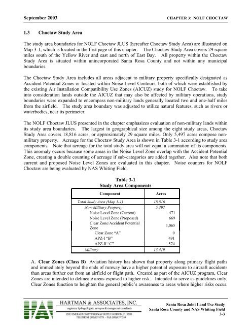
September 2003CHAPTER 3: <strong>NOLF</strong> <strong>CHOCTAW</strong>1.3 Choctaw Study AreaThe study area boundaries for <strong>NOLF</strong> Choctaw <strong>JLUS</strong> (hereafter Choctaw Study Area) are illustrated onMap 3-1, which is located in the first page of this chapter. The Choctaw Study Area covers 29 squaremiles south of the Yellow River and east and north of East Bay. All property within the ChoctawStudy Area is situated within unincorporated <strong>Santa</strong> <strong>Rosa</strong> <strong>County</strong> and not within any municipalboundaries.The Choctaw Study Area includes all areas adjacent to military property specifically designated asAccident Potential Zones or located within Noise Level Contours, both of which were established bythe existing Air Installation Compatibility Use Zones (AICUZ) study for <strong>NOLF</strong> Choctaw. To takeinto consideration lands outside the AICUZ that may also be affected by military operations, studyboundaries were expanded to encompass non-military lands generally located two and one-half milesfrom the airfield. The study area boundary was adjusted to utilize natural features, such as rivers orwaterbodies, near its perimeter.The <strong>NOLF</strong> Choctaw <strong>JLUS</strong> presented in the chapter emphasizes evaluation of non-military lands withinits study area boundaries. The largest in geographical size among the eight study areas, ChoctawStudy Area covers 18,816 acres, or approximately 29 square miles. Only 5,497 acres compose nonmilitaryproperty. Acreage for the Choctaw Study Area is shown in Table 3-1 according to study areacomponents. Note that acreage for the total study area will not equal a summation of its components.This anomaly occurs because some areas in the Noise Level Zone overlap with the Accident PotentialZone, creating a double counting of acreage if sub-categories are added together. Also note that bothcurrent and proposed Noise Level Zones are evaluated in this chapter. Noise counters for <strong>NOLF</strong>Choctaw are being evaluated by NAS Whiting Field.Table 3-1Study Area ComponentsComponentAcresTotal Study Area (Map 3-1) 18,816Non-Military Property 5,397Noise Level Zone (Current) 471Noise Level Zone (Proposed) 669Clear Zone/Accident PotentialZone1,065Clear Zone “A” 0APZ-I “B” 491APZ-II “C” 574Military 13,419A. Clear Zones (Class B) Aviation history has shown that property along primary flight pathsand immediately beyond the ends of runway have a higher potential exposure to aircraft accidentsthan areas further out from an airfield or flight path. Created as part of the AICUZ program, ClearZones are intended to delineate areas exposed to higher risk. Intended to serve as guidelines only,Clear Zones function to heighten the general public’s awareness to areas where higher risks occur.<strong>Santa</strong> <strong>Rosa</strong> Joint Land Use Study<strong>Santa</strong> <strong>Rosa</strong> <strong>County</strong> and NAS Whiting Field3-3