

approach paper on ground water quality issues in islands
approach paper on ground water quality issues in islands
approach paper on ground water quality issues in islands

You also want an ePaper? Increase the reach of your titles
YUMPU automatically turns print PDFs into web optimized ePapers that Google loves.
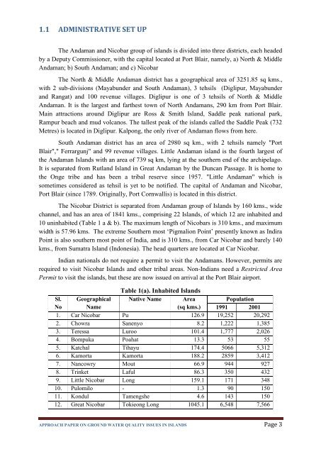
1.1 ADMINISTRATIVE SET UPThe Andaman and Nicobar group of <strong>islands</strong> is divided <strong>in</strong>to three districts, each headedby a Deputy Commissi<strong>on</strong>er, with the capital located at Port Blair, namely, a) North & MiddleAndaman; b) South Andaman; and c) NicobarThe North & Middle Andaman district has a geographical area of 3251.85 sq kms.,with 2 sub-divisi<strong>on</strong>s (Mayabunder and South Andaman), 3 tehsils (Diglipur, Mayabunderand Rangat) and 100 revenue villages. Diglipur is <strong>on</strong>e of 3 tehsils of North & MiddleAndaman. It is the largest and farthest town of North Andamans, 290 km from Port Blair.Ma<strong>in</strong> attracti<strong>on</strong>s around Diglipur are Ross & Smith Island, Saddle peak nati<strong>on</strong>al park,Rampur beach and mud volcanos. The tallest peak of the <strong>islands</strong> called the Saddle Peak (732Metres) is located <strong>in</strong> Diglipur. Kalp<strong>on</strong>g, the <strong>on</strong>ly river of Andaman flows from here.South Andaman district has an area of 2980 sq km., with 2 tehsils namely "PortBlair"," Ferrargunj" and 99 revenue villages. Little Andaman island is the fourth largest ofthe Andaman Islands with an area of 739 sq km, ly<strong>in</strong>g at the southern end of the archipelago.It is separated from Rutland Island <strong>in</strong> Great Andaman by the Duncan Passage. It is home tothe Onge tribe and has been a tribal reserve s<strong>in</strong>ce 1957. "Little Andaman" which issometimes c<strong>on</strong>sidered as tehsil is yet to be notified. The capital of Andaman and Nicobar,Port Blair (s<strong>in</strong>ce 1789. Orig<strong>in</strong>ally, Port Cornwallis) is located <strong>in</strong> this district.The Nicobar District is separated from Andaman group of Islands by 160 kms., widechannel, and has an area of 1841 kms., compris<strong>in</strong>g 22 Islands, of which 12 are <strong>in</strong>habited and10 un<strong>in</strong>habited (Table 1 a & b). The maximum length of Nicobars is 310 kms., and maximumwidth is 57.96 kms. The extreme Southern most „Pigmali<strong>on</strong> Po<strong>in</strong>t‟ presently known as IndiraPo<strong>in</strong>t is also southern most po<strong>in</strong>t of India, and is 310 kms., from Car Nicobar and barely 140kms., from Sumatra Island (Ind<strong>on</strong>esia). The head quarters are located at Car Nicobar.Indian nati<strong>on</strong>als do not require a permit to visit the Andamans. However, permits arerequired to visit Nicobar Islands and other tribal areas. N<strong>on</strong>-Indians need a Restricted AreaPermit to visit the <strong>islands</strong>, but these are now issued <strong>on</strong> arrival at the Port Blair airport.Table 1(a). Inhabited IslandsSl. Geographical Native Name AreaPopulati<strong>on</strong>No Name(sq kms.) 1991 20011. Car Nicobar Pu 126.9 19,252 20,2922. Chowra Sanenyo 8.2 1,222 1,3853. Teressa Luroo 101.4 1,777 2,0264. Bompuka Poahat 13.3 53 555. Katchal Tihayu 174.4 5066 5,3126. Kamorta Kamorta 188.2 2859 3,4127. Nancowry Mout 66.9 944 9278. Tr<strong>in</strong>ket Laful 86.3 350 4329. Little Nicobar L<strong>on</strong>g 159.1 171 34810. Pulomilo - 1.3 90 15011. K<strong>on</strong>dul Tamengshe 4.6 143 15012. Great Nicobar Tokie<strong>on</strong>g L<strong>on</strong>g 1045.1 6,548 7,566APPROACH PAPER ON GROUND WATER QUALITY ISSUES IN ISLANDS Page 3