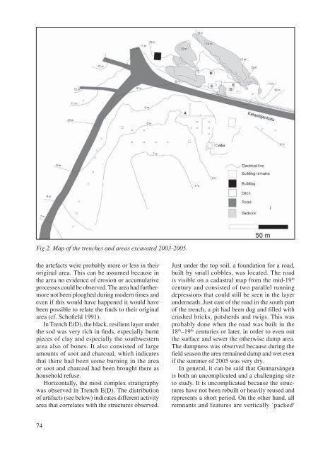
Fig 2. Map of the trenches and areas excavated 2003-2005.the artefacts were probably more or less in theiroriginal area. This can be assumed because inthe area no evidence of erosion or accumulativeprocesses could be observed. The area had furthermorenot been ploughed during modern times andeven if this would have happened it would havebeen possible to relate the finds to their originalarea (cf. Schofield 1991).In Trench E(D), the black, resilient layer underthe sod was very rich in finds, especially burntpieces of clay and especially the southwesternarea also of bones. It also consisted of largeamounts of soot and charcoal, which indicatesthat there had been some burning in the areaor soot and charcoal had been brought there ashousehold refuse.Horizontally, the most complex stratigraphywas observed in Trench E(D). The distributionof artifacts (see below) indicates different activityarea that correlates with the structures observed.Just under the top soil, a foundation for a road,built by small cobbles, was located. The roadis visible on a cadastral map from the mid-19 thcentury and consisted of two parallel runningdepressions that could still be seen in the layerunderneath. Just east of the road in the south partof the trench, a pit had been dug and filled withcrushed bricks, potsherds and twigs. This wasprobably done when the road was built in the18 th –19 th centuries or later, in order to even outthe surface and sewer the otherwise damp area.The dampness was observed because during thefield season the area remained damp and wet evenif the summer of 2005 was very dry.In general, it can be said that Gunnarsängenis both an uncomplicated and a challenging siteto study. It is uncomplicated because the structureshave not been rebuilt or heavily reused andrepresents a short period. On the other hand, allremnants and features are vertically ‘packed’74
close together and often partly mixed because ofthe very thin vertical stratigraphy. Very carefulexcavation techniques are needed to study thesetypes of sites. This might be possible in a researchproject but not necessarily in, for instance, a rescueexcavation with a strict schedule.Structures and featuresIn Trench A, no visible structures could be founddue to the mixing of the sediments. The onlydistinguishable feature was the remnants of alayer of charcoal that was located between theploughed layer and sterile bottom sand. It couldbe originally from the initial burning and clearingphase of a field in the area.A structure was located in Trench C whichconsisted of a rectangular area where fist-sizedand smaller stones had been packed into a singlelayer with an even surface which was preservedin an area of 3.50 x 2.10 m (E–W x N–S). Theeastern edge was laid against the bedrock elevation.In the northeastern corner, also against thebedrock elevation, there was a simple fireplacedug into the sand (diameter 1.20 m, depth 0.50m) with a few heavily burnt cobbles against thebedrock. In the depth of about 0.30 m, the layerinside the fireplace turned completely into charcoaland some large parts of charred tree werecollected for analysis.In the southern part of Trench C, there wasa pit formation dug into the bottom sand. Somestoneware was collected in the bottom layers ofthis pit, but the dating of this structure is unclearbecause the entire filling layer was mixed.In Trench E(D), the structures and featureswere possible to locate only after removing mostof the black, resilient and hard layer, which isdated to the Middle Ages. Underneath it, in thenorthern part of the trench, crossing streaks inthe mineral sand were located and interpreted asremains of ploughing. The crossing pattern indicatesthat the tilling of the soil was done with aplough (Myrdal 1985: 95–6; Gren 1997; Orrman2003: 46). This is indicated also by the fact thatin the northern corner of the field most of theplough marks make nearly 180º turns almost onthe spot, which would not been possible with aplough. The best preserved area is the northernpart of the field. There the marks are between 5–10cm wide and they penetrate the mineral sand to adepth of 5–10 cm. The southern part of the fieldis in its western part disturbed by contemporaryor later medieval activity and in the eastern partby the modern activity described above.The area with the plough marks was borderedin its north and west part by a ditch (about 0.40–0.50 m wide and 0.40–0.50 m in depth) that had atsome stage been filled with a stony layer of sooty,black soil. In the northeastern part, the ploughmarks were not that clear but from the extent ofthe ditch it is clear that the field has continued towardssouth and east of the trench. In 2006, whenthe area towards south was excavated, a bedrockelevation was found. This has been a natural borderof the field. Eastwards of the elevation therewas a ditch running from the ditches borderingthe field. The area of the ancient field has beenonly about 7 x 15 m or about 100 m 2 .The most complicated and versatile area wasthe southwestern and western part of Trench E(D).Based on stratigraphic observations, it has beeninterpreted that the field originally also reachedto this area. The ditch around the field ended inthe bedrock elevation and some remnants of ardmarks were observed under the cultural layers inthe southwestern corner. At some stage the ditchwas directed in a new direction in its western part.It was curved inwards and at the end of the newditch a posthole was located. Two 0.20 cm wide,shallow furrows continued from the posthole, oneto the east and the other to south in 90º relationto each other. Two more postholes were locatedin the eastern part, in north–south direction fromeach other. In a hollow in the bedrock elevation,forming the western border of the area, a hearth orthe base of an open rock stove was located.The ‘packing’ effect described above makesinterpretations of the southwestern part of TrenchE(D) challenging. The layers on top of it wereconsiderably harder and resilient than in other partof the trench, which made it harder to excavate.Typical for this area was also a clear concentrationof burnt clay and bones all packed into thesame resilient layer. Negative marks of branchesand also straws can be observed as also negativesof seeds in many of the pieces of burnt clay. Aninteresting feature was that pieces of wood werefound and excavated in the area. Part of these wasfragments of boards, some about 0.25 m widewith the surface preserved while the rest of thewood hade decayed. The rest were remnants ofround laths, about 0.05–0.10 m in diameter. Allthe wood was at least partly burnt. Also chunks75