

Botany and Wetlands Study Report - McMillen, LLC
Botany and Wetlands Study Report - McMillen, LLC
Botany and Wetlands Study Report - McMillen, LLC

Create successful ePaper yourself
Turn your PDF publications into a flip-book with our unique Google optimized e-Paper software.
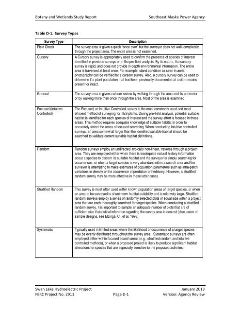
<strong>Botany</strong> <strong>and</strong> Wetl<strong>and</strong>s <strong>Study</strong> <strong>Report</strong>Southeast Alaska Power AgencyTable D‐1. Survey TypesSurvey TypeField CheckCursoryGeneralFocused (IntuitiveControlled)DescriptionThe survey area is given a quick “once over” but the surveyor does not walk completelythrough the project area. The entire area is not examined.A Cursory survey is appropriately used to confirm the presence of species of interestidentified in previous surveys or in the pre-field analysis. By its nature, the cursorysurvey is rapid, <strong>and</strong> does not provide in-depth environmental information. The entirearea is traversed at least once. For example, st<strong>and</strong> condition as seen in aerialphotography can be verified by a cursory survey. Also, a cursory survey can be used todetermine if a plant population that had been previously documented at a site remainspresent or intact.The survey area is given a closer review by walking through the area <strong>and</strong> its perimeteror by walking more than once through the area. Most of the area is examinedThe Focused, or Intuitive Controlled, survey is the most commonly used <strong>and</strong> mostefficient method of surveying for TES plants. During pre-field analysis, potential suitablehabitat is identified for each species of interest <strong>and</strong> the survey effort is focused in thoseareas. This method requires adequate knowledge of suitable habitat in order toaccurately select the areas of focused searching. When conducting intuitive controlledsurveys, an area somewhat larger than the identified suitable habitat should besearched to validate current suitable habitat definitions.R<strong>and</strong>omR<strong>and</strong>om surveys employ an undirected, typically non-linear, traverse through a projectarea. They are employed either when there is inadequate natural history informationabout a species to discern its suitable habitat <strong>and</strong> the surveyor is simply searching foroccurrences, or when a target species is very abundant within a search area <strong>and</strong> thesurveyor is attempting to make estimates of population parameters such as intra-patchvariations in density or the occurrence of predation or herbivory. However, a stratifiedr<strong>and</strong>om survey may be more effective in these latter cases.Stratified R<strong>and</strong>omThis survey is most often used within known population areas of target species, or whenan area to be surveyed is of unknown habitat suitability <strong>and</strong> is relatively large. Stratifiedr<strong>and</strong>om surveys employ a series of r<strong>and</strong>omly selected plots of equal size within a projectarea that are each thoroughly searched for target species. When conducting a stratifiedr<strong>and</strong>om survey, it is important to sample an adequate number of plots that are ofsufficient size if statistical inference regarding the survey area is desired (discussion ofsample designs, see Elzinga, C., et al. 1998).SystematicTypically used in limited areas where the likelihood of occurrence of a target speciesmay be evenly distributed throughout the survey area. Systematic surveys are oftenemployed either within focused search areas (e.g., stratified r<strong>and</strong>om <strong>and</strong> intuitivecontrolled methods), or when a proposed project is likely to produce significant habitatalterations for species that are especially sensitive to the proposed activities.Swan Lake Hydroelectric Project January 2013FERC Project No. 2911 Page D‐1 Version: Agency Review