- Page 2 and 3:
NATURAL DISASTER RESEARCH, PREDICTI
- Page 4 and 5:
NATURAL DISASTER RESEARCH, PREDICTI
- Page 6 and 7:
CONTENTSPrefaceChapter 1Chapter 2Ch
- Page 8 and 9:
PREFACEA landslide is a geological
- Page 10 and 11:
Prefaceix1000 m 3 , rarely 10,000 m
- Page 12 and 13:
Prefacexidemonstrates the principle
- Page 14 and 15:
In: Landslides: Causes, Types and E
- Page 16 and 17:
Mass Movements in Adriatic Central
- Page 18 and 19:
Mass Movements in Adriatic Central
- Page 20 and 21:
Mass Movements in Adriatic Central
- Page 22 and 23:
Mass Movements in Adriatic Central
- Page 24 and 25:
Mass Movements in Adriatic Central
- Page 26 and 27:
Mass Movements in Adriatic Central
- Page 28 and 29:
Mass Movements in Adriatic Central
- Page 30 and 31:
Mass Movements in Adriatic Central
- Page 32 and 33:
Mass Movements in Adriatic Central
- Page 34 and 35:
Mass Movements in Adriatic Central
- Page 36 and 37:
Mass Movements in Adriatic Central
- Page 38 and 39:
Mass Movements in Adriatic Central
- Page 40 and 41:
Mass Movements in Adriatic Central
- Page 42 and 43:
Mass Movements in Adriatic Central
- Page 44 and 45:
Mass Movements in Adriatic Central
- Page 46 and 47:
Mass Movements in Adriatic Central
- Page 48 and 49:
Mass Movements in Adriatic Central
- Page 50 and 51:
Mass Movements in Adriatic Central
- Page 52 and 53:
Mass Movements in Adriatic Central
- Page 54 and 55:
Mass Movements in Adriatic Central
- Page 56 and 57:
Mass Movements in Adriatic Central
- Page 58 and 59:
Mass Movements in Adriatic Central
- Page 60:
Mass Movements in Adriatic Central
- Page 63 and 64:
50Domenico Aringoli, Bernardino Gen
- Page 65 and 66:
52Domenico Aringoli, Bernardino Gen
- Page 67 and 68:
54Domenico Aringoli, Bernardino Gen
- Page 69 and 70:
56Domenico Aringoli, Bernardino Gen
- Page 71 and 72:
58Domenico Aringoli, Bernardino Gen
- Page 73 and 74:
60Domenico Aringoli, Bernardino Gen
- Page 75 and 76:
62Domenico Aringoli, Bernardino Gen
- Page 77 and 78:
64Domenico Aringoli, Bernardino Gen
- Page 79 and 80:
66Domenico Aringoli, Bernardino Gen
- Page 81 and 82:
68Domenico Aringoli, Bernardino Gen
- Page 83 and 84:
70Domenico Aringoli, Bernardino Gen
- Page 86 and 87:
In: Landslides: Causes, Types and E
- Page 88 and 89:
Causes and Effects of Landslides in
- Page 90 and 91:
Causes and Effects of Landslides in
- Page 92 and 93:
Causes and Effects of Landslides in
- Page 94 and 95:
Causes and Effects of Landslides in
- Page 96 and 97:
Causes and Effects of Landslides in
- Page 98 and 99:
Causes and Effects of Landslides in
- Page 100 and 101:
Causes and Effects of Landslides in
- Page 102 and 103:
Causes and Effects of Landslides in
- Page 104 and 105:
Causes and Effects of Landslides in
- Page 106 and 107:
Causes and Effects of Landslides in
- Page 108 and 109:
Causes and Effects of Landslides in
- Page 110 and 111:
Causes and Effects of Landslides in
- Page 112 and 113:
Causes and Effects of Landslides in
- Page 114 and 115:
Causes and Effects of Landslides in
- Page 116 and 117:
Causes and Effects of Landslides in
- Page 118 and 119: In: Landslides: Causes, Types and E
- Page 120 and 121: Mitigation of Large Landslides and
- Page 122 and 123: Mitigation of Large Landslides and
- Page 124 and 125: Mitigation of Large Landslides and
- Page 126 and 127: Mitigation of Large Landslides and
- Page 128 and 129: Mitigation of Large Landslides and
- Page 130 and 131: Mitigation of Large Landslides and
- Page 132 and 133: Mitigation of Large Landslides and
- Page 134 and 135: Mitigation of Large Landslides and
- Page 136 and 137: Mitigation of Large Landslides and
- Page 138 and 139: Mitigation of Large Landslides and
- Page 140 and 141: Mitigation of Large Landslides and
- Page 142 and 143: Mitigation of Large Landslides and
- Page 144: Mitigation of Large Landslides and
- Page 147 and 148: 134L. Borgatti, L. Vittuari and A.
- Page 149 and 150: 136L. Borgatti, L. Vittuari and A.
- Page 151 and 152: 138L. Borgatti, L. Vittuari and A.
- Page 153 and 154: 140L. Borgatti, L. Vittuari and A.
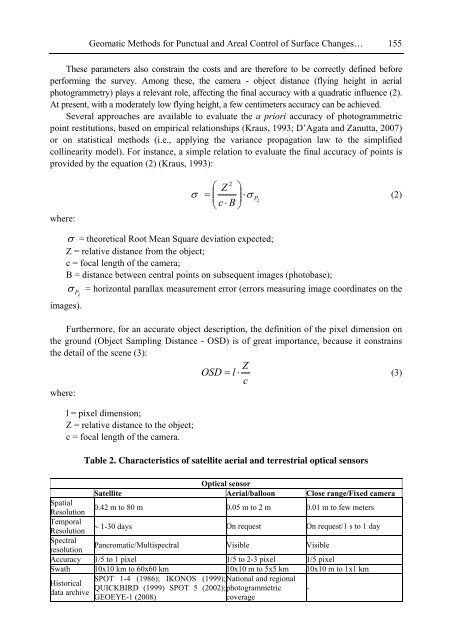
- Page 155 and 156: 142L. Borgatti, L. Vittuari and A.
- Page 157 and 158: 144L. Borgatti, L. Vittuari and A.
- Page 159 and 160: 146L. Borgatti, L. Vittuari and A.
- Page 161 and 162: 148L. Borgatti, L. Vittuari and A.
- Page 163 and 164: 150L. Borgatti, L. Vittuari and A.
- Page 165 and 166: 152L. Borgatti, L. Vittuari and A.
- Page 167: 154L. Borgatti, L. Vittuari and A.
- Page 171 and 172: 158L. Borgatti, L. Vittuari and A.
- Page 173 and 174: 160L. Borgatti, L. Vittuari and A.
- Page 175 and 176: 162L. Borgatti, L. Vittuari and A.
- Page 177 and 178: 164L. Borgatti, L. Vittuari and A.
- Page 179 and 180: 166L. Borgatti, L. Vittuari and A.
- Page 181 and 182: 168L. Borgatti, L. Vittuari and A.
- Page 183 and 184: 170L. Borgatti, L. Vittuari and A.
- Page 185 and 186: 172L. Borgatti, L. Vittuari and A.
- Page 187 and 188: 174L. Borgatti, L. Vittuari and A.
- Page 189 and 190: 176L. Borgatti, L. Vittuari and A.
- Page 191 and 192: 178A.R. Agatova and R.K. NepopIntro
- Page 193 and 194: 180A.R. Agatova and R.K. NepopThus
- Page 195 and 196: 182A.R. Agatova and R.K. Nepopknown
- Page 197 and 198: 184A.R. Agatova and R.K. NepopFigur
- Page 199 and 200: 186A.R. Agatova and R.K. Nepop4. Lo
- Page 201 and 202: 188A.R. Agatova and R.K. Nepopconto
- Page 203 and 204: 190A.R. Agatova and R.K. NepopEstim
- Page 205 and 206: 192A.R. Agatova and R.K. NepopChuya
- Page 207 and 208: 194A.R. Agatova and R.K. Nepopthe l
- Page 209 and 210: 196A.R. Agatova and R.K. NepopBulat
- Page 211 and 212: 198A.R. Agatova and R.K. NepopSklja
- Page 214 and 215: In: Landslides: Causes, Types and E
- Page 216 and 217: Recognition of Likely Large-Scale L
- Page 218 and 219:
Recognition of Likely Large-Scale L
- Page 220 and 221:
Recognition of Likely Large-Scale L
- Page 222:
Recognition of Likely Large-Scale L
- Page 225 and 226:
212 Tsuyoshi Ichimura and Muneo Hor
- Page 227 and 228:
214 Tsuyoshi Ichimura and Muneo Hor
- Page 229 and 230:
216 Tsuyoshi Ichimura and Muneo Hor
- Page 231 and 232:
218 Tsuyoshi Ichimura and Muneo Hor
- Page 233 and 234:
m)entpladism)entpladisbcedlmbcedlms
- Page 235 and 236:
222 Tsuyoshi Ichimura and Muneo Hor
- Page 238 and 239:
In: Landslides: Causes, Types and E
- Page 240 and 241:
Prediction of the Seismic Displacem
- Page 242 and 243:
Prediction of the Seismic Displacem
- Page 244 and 245:
Prediction of the Seismic Displacem
- Page 246 and 247:
Prediction of the Seismic Displacem
- Page 248 and 249:
Prediction of the Seismic Displacem
- Page 250 and 251:
Prediction of the Seismic Displacem
- Page 252 and 253:
Prediction of the Seismic Displacem
- Page 254 and 255:
Prediction of the Seismic Displacem
- Page 256 and 257:
Prediction of the Seismic Displacem
- Page 258 and 259:
Prediction of the Seismic Displacem
- Page 260 and 261:
Prediction of the Seismic Displacem
- Page 262 and 263:
Prediction of the Seismic Displacem
- Page 264 and 265:
In: Landslides: Causes, Types and E
- Page 266 and 267:
Faults Activity, Landslides and Flu
- Page 268 and 269:
Faults Activity, Landslides and Flu
- Page 270 and 271:
Faults Activity, Landslides and Flu
- Page 272 and 273:
Faults Activity, Landslides and Flu
- Page 274:
Faults Activity, Landslides and Flu
- Page 277 and 278:
264 Jiří Nedomaods for numerical
- Page 279 and 280:
266 Jiří NedomaFigure 5. Combinat
- Page 281 and 282:
268 Jiří Nedomaquakes or shocks a
- Page 283 and 284:
270 Jiří Nedomaan important role
- Page 285 and 286:
272 Jiří NedomaFrom the momentum
- Page 287 and 288:
274 Jiří Nedomain velocities. The
- Page 289 and 290:
276 Jiří Nedoma(A) Multibody cont
- Page 291 and 292:
278 Jiří NedomaFigure 8. Coeffici
- Page 293 and 294:
280 Jiří NedomaHence and from (34
- Page 295 and 296:
282 Jiří Nedomawhere F klc is a c
- Page 297 and 298:
284 Jiří Nedomamethods and algori
- Page 299 and 300:
286 Jiří Nedoma2.2.2. Variational
- Page 301 and 302:
288 Jiří Nedomaunique solution an
- Page 303 and 304:
290 Jiří NedomaLet 1 V h and V h
- Page 305 and 306:
292 Jiří NedomaChoose λ 0 h ∈
- Page 307 and 308:
294 Jiří Nedomaor not)α k+1 =
- Page 309 and 310:
296 Jiří Nedomatervals. The coeff
- Page 311 and 312:
298 Jiří NedomaIf one of the coll
- Page 313 and 314:
300 Jiří Nedomaelastic problem (s
- Page 315 and 316:
302 Jiří Nedomawith approximate i
- Page 317 and 318:
304 Jiří NedomaFrom the estimates
- Page 319 and 320:
306 Jiří Nedomaevolution. In the
- Page 321 and 322:
308 Jiří Nedomaτ ij n j = P i ,i
- Page 323 and 324:
310 Jiří Nedomatime element. In t
- Page 325 and 326:
312 Jiří Nedomaholds, where(u ′
- Page 327 and 328:
314 Jiří Nedomaconst. > 0, |a (n)
- Page 329 and 330:
316 Jiří Nedomawhere C is the glo
- Page 331 and 332:
318 Jiří Nedomawhere[v · n] s =
- Page 333 and 334:
320 Jiří Nedomawhere‖v h ‖ 1
- Page 335 and 336:
322 Jiří Nedomafor the quasi-stat
- Page 337 and 338:
324 Jiří Nedomak, l ∈{N, M, S}.
- Page 339 and 340:
326 Jiří NedomaSTEP 3. Set A k+1
- Page 341 and 342:
328 Jiří NedomaThe discrete appro
- Page 343 and 344:
330 Jiří Nedomaelasticity, which
- Page 345 and 346:
332 Jiří Nedomar∑∫ ∫(F, v)
- Page 347 and 348:
334 Jiří Nedomau 2 (x,t) ∈ L 2
- Page 349 and 350:
336 Jiří Nedomawhich are well-def
- Page 351 and 352:
338 Jiří Nedoma|T ε (t)| 2 0 +2c
- Page 353 and 354:
340 Jiří NedomaA priori estimates
- Page 355 and 356:
342 Jiří Nedoma|b p (u ′′ε(t
- Page 357 and 358:
344 Jiří NedomaFrom (192), (193)
- Page 359 and 360:
346 Jiří Nedomaa(u(t), v)+∫ t0a
- Page 361 and 362:
348 Jiří Nedomaindependent. Then
- Page 363 and 364:
350 Jiří NedomaFor the proof see
- Page 365 and 366:
352 Jiří Nedomaand using the nota
- Page 367 and 368:
354 Jiří Nedoma(i) the geometry o
- Page 369 and 370:
356 Jiří NedomaThroughtout the pa
- Page 371 and 372:
358 Jiří NedomaSince the function
- Page 373 and 374:
360 Jiří Nedomawith (256), where
- Page 375 and 376:
362 Jiří Nedoma{m h |‖m h ‖
- Page 377 and 378:
364 Jiří Nedomain which the incom
- Page 379 and 380:
366 Jiří NedomaProblem (P mi ) hk
- Page 381 and 382:
368 Jiří Nedomawell as the bridge
- Page 383 and 384:
370 Jiří Nedomabridge pier is bad
- Page 385 and 386:
372 Jiří NedomaFigure 18. The def
- Page 387 and 388:
374 Jiří NedomaFigure 20. The mod
- Page 389 and 390:
376 Jiří NedomaFigure 23. The Ale
- Page 391 and 392:
378 Jiří NedomaFigure 26. The loa
- Page 393 and 394:
380 Jiří NedomaFigure 30. The loa
- Page 395 and 396:
382 Jiří NedomaFigure 34. The loa
- Page 397 and 398:
384 Jiří Nedoma• temperature an
- Page 399 and 400:
386 Jiří Nedoma[23] I. Hlaváček
- Page 401 and 402:
388 Jiří Nedoma[54] J. Nedoma, On
- Page 404 and 405:
INDEXAABC, 219Abundance, 204accessi
- Page 406 and 407:
Index 393convex, 17, 18, 20, 31, 58
- Page 408 and 409:
Index 395116, 117, 124, 125, 129, 1
- Page 410 and 411:
Index 397Kkinematics, 2, 3, 7, 18,
- Page 412 and 413:
Index 399optical, 151, 155, 156, 16
- Page 414 and 415:
Index 401sampling, 136, 162, 164, 1
- Page 416 and 417:
Index 403transformation, 15, 54, 55