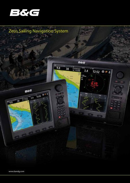
Zeus Sailing Navigation System
Zeus Sailing Navigation System - Europe, MIddle East & Africa - B&G
Zeus Sailing Navigation System - Europe, MIddle East & Africa - B&G
- No tags were found...

You also want an ePaper? Increase the reach of your titles
YUMPU automatically turns print PDFs into web optimized ePapers that Google loves.
<strong>Zeus</strong> <strong>Sailing</strong> <strong>Navigation</strong> <strong>System</strong><br />
www.bandg.com
B&G. Passionate about sailing<br />
Gypsy Moth<br />
Nautor’s Swan<br />
Volvo Ocean Race<br />
Rick Deppe – PUMA Ocean Racing-Volvo Ocean Race<br />
The choice of the performance sailor for over<br />
50 years, B&G leads the way in sailing electronics,<br />
delivering nothing but the highest standard of<br />
products and support.<br />
The best sailors in the world choose B&G because<br />
they value the performance, durability and outstanding<br />
support. B&G provides them with the tools to enable<br />
them to be the best in whatever they do.<br />
The constant challenge to develop new technological<br />
solutions has provided our people with a wealth of<br />
experience and knowledge, enabling B&G to harness<br />
technical developments and provide proven solutions<br />
for every sailor’s need.<br />
This technology has been made available and tailored<br />
to the needs of cruisers and club racers alike, in an easy<br />
to use and understandable format.<br />
When you speak to anyone in the B&G team you are<br />
speaking to people who are passionate about sailing.<br />
Our sales, customer support and R&D teams are regularly<br />
on the water and understand the needs of the sailor, not<br />
only from professional racers but also from sailors who<br />
simply want to go sailing with the utmost confidence<br />
in their instrument, navigation and autopilot systems.<br />
“ We chose B&G because they have the<br />
right product and the best support.”<br />
Russell Coutts
Sailboat <strong>Navigation</strong><br />
Direct Access keys<br />
■ One-touch access to Chart, Radar<br />
and <strong>Navigation</strong> information<br />
■ Add custom pages to suit your<br />
navigation requirements<br />
■ First touch of each key recalls the<br />
last viewed page for quick, easy operation<br />
CHART<br />
INSTRUMENTS<br />
<strong>Zeus</strong> provides key sail navigation<br />
data overlaid onto premium<br />
embedded cartography<br />
■ Instant chart zoom with Rotary controller<br />
■ Incredibly clear chart display, easy to switch<br />
between boat and cursor position<br />
■ Easy navigation including goto cursor and<br />
goto waypoint along with straightforward<br />
route builder<br />
■ AIS and MARPA target overlay<br />
■ Radar overlay<br />
■ Dedicated Sail <strong>Navigation</strong> overlay<br />
■ Weather overlay<br />
■ Additional card slot for optional charts,<br />
including Navionics Platinum+ with<br />
3D Turboview and high-resolution<br />
aerial photography<br />
The <strong>Zeus</strong> navigator is able to assess the prevailing conditions<br />
and trends by full integration of the available instrument data.<br />
Direct integration with B&G H3000 instruments gives the most<br />
accurate data available to assess the conditions and enables<br />
configuration of instrument functions including Polar Tables*<br />
and True Wind Corrections<br />
<strong>Zeus</strong> supports B&G H-Link, NMEA0183 or NMEA2000<br />
compatible instruments<br />
■ TimePlot shows user selected data history over time,<br />
ideal for assessing barometric pressure, depth or wind speed trends<br />
■ WindPlot provides a True Wind Speed and Direction plot, allowing<br />
the sailor to make decisions on route choice – whether to tack,<br />
or stand on - for fast and safe passage making<br />
■ Instrument panels display your choice of navigation<br />
or instrument data in a selection of formats<br />
■ Polar tables entered for your design of boat to enable<br />
you to sail to the boats optimum performance.
Rotary controller:<br />
■ Straightforward menu control,<br />
with push-to-enter function<br />
■ Intuitive use for zooming, radar gain and more<br />
Alphanumeric keypad<br />
■ Quick and accurate entry of position or name<br />
information for waypoints, routes and tracks<br />
USB<br />
■ Front USB port protected by IP67 cover<br />
■ File management via USB stick, allows quick update<br />
of GRIB weather forecasts and log file offload<br />
WEATHER<br />
SAIL NAVIGATION<br />
RADAR<br />
The ability to view up to date forecast<br />
data gives the <strong>Zeus</strong> user a clear<br />
advantage in understanding the<br />
likely conditions that they may face.<br />
■ Wind Speed and Direction<br />
■ Barometric pressure with pressure<br />
centre indicators<br />
■ Manual time step control –<br />
forward or back – to select any<br />
available forecast time<br />
■ Animation option shows how<br />
weather systems are likely to<br />
develop and allows the sailor to<br />
take appropriate steps to prepare,<br />
or route around<br />
■ Cursor Info feature allows quick<br />
assessment of the forecast at a<br />
particular location and time<br />
■ GRIB weather files can be easily<br />
uploaded via the USB port<br />
The most important sailing data is overlaid onto<br />
the <strong>Zeus</strong> chart screen, enabling an assessment<br />
of the realistic route to be sailed, rather than a<br />
simple straight-line waypoint to waypoint route<br />
which is rarely followed by sailors!<br />
■ Water and Ground vectors show the effect<br />
of tide and leeway on your course<br />
■ Mark and Boat Layline positions are displayed<br />
with the user’s choice of setting, ideal for<br />
assessing whether you are able to clear a<br />
headland or obstacle on your next tack.<br />
- Manual Wind Angle input<br />
- Actual True Wind Angle from instruments<br />
- Polar Target Wind angle from<br />
H3000 instruments*<br />
- Option to correct layline positions<br />
for measured tidal flow<br />
■ Historic min/max layline positions allow<br />
the navigator to make a safe decision to<br />
tack for a headland based on recent wind<br />
direction changes<br />
■ Time and Distance to layline information<br />
is provided for each tack, allowing easy<br />
preparation for manoeuvres<br />
<strong>Zeus</strong> delivers outstanding radar functionality<br />
■ Marpa targets acquired and displayed<br />
alongside AIS targets, giving awareness<br />
of all traffic in your area<br />
■ True Motion and trails ensure the<br />
user can easily determine whether the<br />
target is moving or stationary<br />
■ Range Markers, Bearing Lines and Guard<br />
Zones allow the user to track relative<br />
positions and ensure safe navigation<br />
■ Excellent target discrimination shows the<br />
difference between one large vessel or two<br />
smaller ones in close proximity<br />
■ Incredible close range performance allows<br />
you to pick out individual mooring buoys<br />
in the dark or in low visibility<br />
* Polar option requires Hercules Performance or Hercules Motion CPU software level.
Expanding your options<br />
Masthead<br />
Unit<br />
Broadband Radar<br />
Broadband Radar provides amazing target resolution.<br />
Docks, channel markers, moored vessels and other critical<br />
targets are displayed with clarity and separation, even<br />
at close quarters. Broadband Radar also eliminates the<br />
“main bang” of a pulse radar – the obscured “dead zone”<br />
immediately around the vessel – which interferes with<br />
close target detection.<br />
20/20HV<br />
Displays<br />
GFD Displays<br />
H3000<br />
CPU<br />
■<br />
■<br />
■<br />
■<br />
■<br />
Crystal clear image of your immediate surroundings<br />
Excellent target discrimination for high confidence<br />
in identification of targets<br />
Automatic tuning removes the requirement<br />
to be a radar expert to obtain great performance<br />
InstantOn allows the operator to be checking<br />
for dangers within seconds rather than minutes<br />
– no warm up time<br />
The lowest power consumption of any X-band marine<br />
radar, ideal for sailboats<br />
H3000<br />
GPD Display<br />
Pilot Processor<br />
<strong>Zeus</strong> is compatible with both Broadband Radar<br />
and a wider range of radar scanners from 2 kW HD<br />
radomes up to 25 kW open arrays.<br />
Speed & Depth<br />
Sensors<br />
Typical system, integrating <strong>Zeus</strong> navigation, Broadband Radar<br />
and B&G H3000 instrument system<br />
<strong>Zeus</strong> GPS Antenna<br />
Confidence in your position is one of the critical<br />
requirements of a sailing navigation system. The <strong>Zeus</strong><br />
ZG50 GPS Antenna provides high accuracy position,<br />
course and speed five times every second ensuring<br />
maximum confidence in the displayed position.<br />
Broadband Sounder and StructureScan<br />
<strong>Zeus</strong> is compatible with a range of echo sounders,<br />
including the ground-breaking StructureScan<br />
and Broadband Sounder technologies.<br />
The ZG50 is connected by SimNet to the <strong>Zeus</strong> displays,<br />
ensuring that all units use the same GPS position data<br />
no matter where they are located in the yacht.<br />
Compact design allows deck or pushpit mounting<br />
locations to be selected.<br />
StructureScan<br />
Broadband Sounder
<strong>Zeus</strong> Z12<br />
ZG50<br />
Broadband Radar<br />
GPS<br />
Ant<br />
7 way joiner<br />
Gimballed Rate<br />
Compass<br />
AIS<br />
NAIS-300<br />
VHF Antenna<br />
NMEA 2000<br />
Radio<br />
RI10<br />
AIS (Automatic Identification <strong>System</strong>)<br />
<strong>Zeus</strong> integrates with the NAIS-300<br />
Class B AIS transceiver. Class B AIS<br />
transceivers both receive other vessels<br />
positions and transmit your position<br />
– allowing you to see and be seen.<br />
The NAIS-300 connects directly to <strong>Zeus</strong><br />
via SimNet, providing the <strong>Zeus</strong> navigator<br />
with display of all AIS equipped vessels<br />
within VHF range. Vessel data such as<br />
MMSI Number, Vessel Name, Call Sign<br />
and Type is available, along with dynamic<br />
data including Position, Course, Distance<br />
and more. Either from ship-to-ship,<br />
or ship-to-shore traffic stations.<br />
Halcyon Gyro<br />
Stabilised Compass<br />
Rudder<br />
Sensor<br />
Hydraulic RAM<br />
StructureScan takes sonar imaging<br />
of the sea-bed to the next level. Using<br />
high-frequency DownScan Imaging<br />
along with SideScan. StructureScan<br />
provides the ability to see incredible<br />
detail of what is below the keel and<br />
around the yacht – invaluable when<br />
creeping into shallow coves or seeking<br />
ideal anchorages. Rocks, cables and<br />
lobster pots can often be picked out<br />
in areas which may otherwise seem<br />
like perfect anchorages.<br />
Entertainment<br />
<strong>Zeus</strong> integrates with SonicHub multimedia systems,<br />
providing multi-zone audio from sources including mp3 USB<br />
and iPod devices along with an integrated FM/AM tuner*<br />
SonicHub consolidates multiple input/output sources into<br />
one system, all controlled from any <strong>Zeus</strong> display on your boat.<br />
Multi-zone allows the navigator to listen to the weather forecast<br />
on the radio at the chart table, while guests relax on deck<br />
with music.<br />
<strong>Zeus</strong> is also compatible with the LWX-1 Sirius Satellite<br />
Radio/weather module (available in USA only).<br />
*FM/AM antenna required
Specifications<br />
Display Z8 Z12<br />
Display Resolution 800 x 600 (H x W) 1024 x 768 (H x W)<br />
Display Type 8 inch Colour TFT LCD 12.1 inch Colour TFT LCD<br />
Networking<br />
Interfaces SimNet, Ethernet, B&G H-Link SimNet, Ethernet, B&G H-Link<br />
NMEA 0183 Interface Input: GLL, GGA, RMC, RMB, GSA, GSV, APB, BWC, Input: GLL, GGA, RMC, RMB, GSA, GSV, APB, BWC,<br />
DBT, DPT, MTW, VLW, VHW, HDG<br />
DBT, DPT, MTW, VLW, VHW, HDG<br />
NMEA Output GGA, GLL, GSA, GSV, VTG, ZDA, AAM, APB, BOD, GGA, GLL, GSA, GSV, VTG, ZDA, AAM, APB, BOD,<br />
BWC, BWR, RMC, RMB, XTE, DBT, DPT, MTW, VLW,<br />
BWC, BWR, RMC, RMB, XTE, DBT, DPT, MTW, VLW,<br />
VHW, HDG, MWV, TLL, TTM<br />
VHW, HDG, MWV, TLL, TTM<br />
Technical<br />
Housing Die-cast Aluminum Rear housing & Front panel. Die-cast Aluminum Rear housing & Front panel.<br />
Plastic front bezel<br />
Plastic front bezel<br />
Waterproof Standard IPx7 IPx7<br />
Width 285 mm \ 11.2 in 356 mm \ 14 in<br />
Height 212 mm \ 8.3 in 273 mm \ 10.7 in<br />
Depth 122.7 mm \ 4.8 in 122.7 mm \ 4.8 in<br />
Power<br />
Power Supply 12.0 VDC-24.0 VDC (9.0 - 32.0 VDC Min-Max) 12.0 VDC-24.0 VDC (9.0 - 32.0 VDC Min-Max)<br />
Power Consumption 21.6 W or 1.8A @ 12.0 VDC or 21.6 W or 0.9A @ 24 VDC 33.6 W or 2.8A @ 12.0 VDC or 33.6 W or 1.4 A @ 24 VDC<br />
NMEA 2000® Load 1 network load (50mA) 1 network load (50mA)<br />
Equivalency Number<br />
Other<br />
Languages English (UK), English (US), German, French, Spanish, Italian, English (UK), English (US), German, French, Spanish, Italian,<br />
Portuguese, Croatian, Finnish, Icelandic, Dutch, Norwegian,<br />
Portuguese, Croatian, Finnish, Icelandic, Dutch, Norwegian,<br />
Polish, Swedish, Slovenian, Russian, Ukrainian, Bulgarian<br />
Polish, Swedish, Slovenian, Russian, Ukrainian, Bulgarian<br />
Operating Temperature -15 0 C to +55 0 C (+5 0 F to +131 0 F) -15 0 C to +55 0 C (+5 0 F to +131 0 F<br />
Radar<br />
BR24<br />
Antenna<br />
ZG50<br />
Antenna Beam Width 5.2°+/-10% (-3dB width) °<br />
Antenna Beam Width 30°+/-20% (-3dB width) °<br />
Antenna Rotation Speed 24 rpm +/- 10% RPMs<br />
Radar Noise<br />
6 dB<br />
Radar Warm Up Time 0 min<br />
Radar Wind Resistance 51 m/sec (Max: 100 Knots)<br />
Communications<br />
GPS Antenna Type<br />
GPS Receiver Channels<br />
GPS Position Accuracy<br />
GPS: Tracking Capability<br />
DGPS: Receiver Type<br />
DGPS: Start-Up Time<br />
DGPS: Frequency Range<br />
Networking<br />
SimNet NMEA2000<br />
16 channels<br />
3 m \ 10 ft<br />
12 Satellites tracking. Tracking velocity < 1000 knots<br />
SIRF III Chip<br />
Cold start