

Transportation
Illinois State Transportation Plan 2012 Book
Illinois State Transportation Plan 2012 Book
- No tags were found...

Create successful ePaper yourself
Turn your PDF publications into a flip-book with our unique Google optimized e-Paper software.
12 | Illinois State <strong>Transportation</strong> Plan 2012<br />
Aviation<br />
Illinois has a network of 110 public-use aviation landing facilities statewide ranging from<br />
O’Hare International Airport (the second busiest airport in the world) to the rural grass strip.<br />
Of the public-use airports, 81 are operated by public agencies and the rest are privately-owned<br />
airports open to the public. In total, there are over 750 aviation facilities (including heliports,<br />
balloon, glider and ultra-light landing facilities and grass landing strips) throughout the state.<br />
These facilities foster connections between communities large and small, provide landing<br />
space for medical transporters, and enhance aviation enthusiasts’ quality of life.<br />
Capital improvement funding for airports comes from several sources, with primary<br />
funding from the FAA’s Airport Improvement Program and the State of Illinois. Local dollars<br />
are generally used to meet the required matching funds for projects.<br />
O’Hare International Airport is ranked second in the nation in enplanements, and sixth in<br />
air cargo activity. To reduce weather-related delays and increase capacity, the City of Chicago<br />
initiated a major improvement program for O’Hare, known as the O’Hare Modernization<br />
Program (OMP). A new runway, an existing runway extension, and a new air traffic control<br />
tower were constructed in 2008. Other projects under development include three additional<br />
runways, an extension to an existing runway, a second new air traffic control tower, and<br />
new cargo warehousing.<br />
In 1998, a South Suburban Airport site was selected as a new third airport in the Chicago<br />
region near Peotone (approximately 40 miles south of Chicago) and environmental<br />
studies began. Taking a phased approach to airport development, the project studies are<br />
concentrated on a five-year inaugural airport program<br />
and an ultimate airport build-out. The inaugural airport<br />
program consists of a single runway, a passenger terminal<br />
with six to nine gates, and air cargo and general aviation<br />
facilities on approximately 5,000 acres.<br />
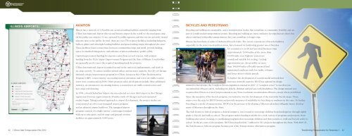
Bicycles and Pedestrians<br />
Bicycling and walking are sustainable, active transportation modes that contribute to community livability and are<br />
part of a multi-modal transportation system. Bicycling and walking are most conducive for trips that are short, but<br />
when combined with public transportation, they can contribute to longer trips.<br />
Illinois has hundreds of miles of dedicated bicycle trails. The recent expansions of bicycle facilities,<br />
especially in the state’s metropolitan areas, have focused on facilitating greater use of bicycles<br />
for commutes to work and personal business trips.<br />
Approximately 5,000 miles of the more than<br />
16,000-mile state highway system are<br />
considered suitable for cycling. Cycling<br />
opportunities are also possible on more<br />
than 100,000 miles of locally operated and<br />
maintained roadways with low traffic volumes<br />
and lower motor vehicle speeds.<br />
To further the development of a multi-modal network that<br />
increases network capacity, IDOT has updated its design<br />
manual to incorporate the Complete Streets legislation enacted in 2007. A “complete street” is one that can<br />
accommodate all users safely, including the elderly, children and persons with disabilities. The design manual now<br />
requires that if there is a need, improvements to any State road must accommodate all users, except where prohibited.<br />
Since the inception of the bicycle program, one initiative was the development of the statewide bicycle maps. These<br />
maps cover the state by IDOT District and provide measures of suitability for bicycling on roadways in the state. To further<br />
bicycling as a mode of transportation, IDOT is in the process of developing a bikeways plan that will guide future development<br />
of bikeways throughout the State.<br />
The Safe Routes to School program, a federal initiative, was created to encourage children from kindergarten through eighth<br />
grade to bicycle and walk to school. The program makes funding available for a wide variety of programs and projects, from<br />
building safer street crossings to establishing programs that encourage children and their parents to walk and bicycle safely to<br />
school. In the six years of the program, IDOT has awarded $43.7 million for 513 projects throughout the State. With MAP-21,<br />
the Safe Routes to Schools program became part of the <strong>Transportation</strong> Alternatives program.<br />
Transforming <strong>Transportation</strong> for Tomorrow |<br />
13