

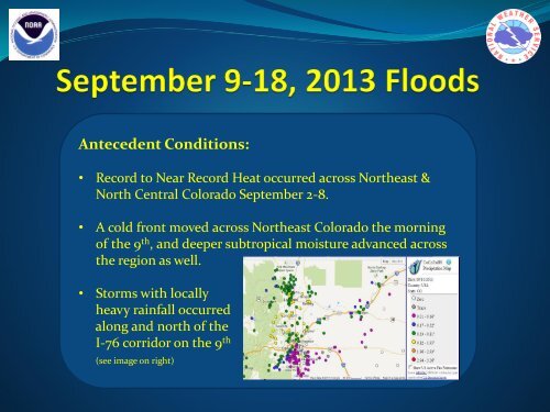
Antecedent Conditions
Sep2013Flood
Sep2013Flood
- No tags were found...

Create successful ePaper yourself
Turn your PDF publications into a flip-book with our unique Google optimized e-Paper software.
<strong>Antecedent</strong> <strong>Conditions</strong>:<br />
• Record to Near Record Heat occurred across Northeast &<br />
North Central Colorado September 2-8.<br />
• A cold front moved across Northeast Colorado the morning<br />
of the 9 th , and deeper subtropical moisture advanced across<br />
the region as well.<br />
• Storms with locally<br />
heavy rainfall occurred<br />
along and north of the<br />
I-76 corridor on the 9 th<br />
(see image on right)
Tuesday, September 10:<br />
• An upper level low remained over the desert southwest, while<br />
subtropical moisture moved<br />
north across Colorado.<br />
(water vapor imagery to right)<br />
• The atmosphere was abnormally<br />
wet, with precipitable water of<br />
36.5 mm (1.44 inches) on the<br />
6 PM, Sep 10 th Denver Sounding
Tuesday, September 10 (cont.):<br />
• While showers and a few storms developed in a very moist<br />
environment, generally moderate rainfall amounts occurred<br />
along the Front Range with 0.25” to 1.25” amounts common.<br />
Nearly 2” of rain fell with the strongest storms over the<br />
southeastern sections of Denver, as well as near Boulder.
Wednesday, September 11:<br />
• The upper level low in the desert southwest drifted slowly<br />
northward, with deeper subtropical<br />
moisture shifting north & east<br />
across eastern Colorado.<br />
(water vapor imagery to right)<br />
• The atmosphere remained quite<br />
moist, with the 6 AM and 6 PM<br />
Denver soundings indicating<br />
precipitable water<br />
values near 33 mm<br />
(1.30 inches).
Wednesday, September 11:<br />
• Initially, showers that developed in the afternoon were<br />
moving fast enough and were small enough to produce<br />
generally moderate rainfall amounts. (Front Range Radar imagery)<br />
1 PM<br />
Sept 11
Wednesday, September 11:<br />
3 PM<br />
Sept 11
Wednesday, September 11:<br />
• However, rain along the Front Range began to intensify and<br />
become more widespread in the evening. (Front Range Radar imagery)<br />
7 PM<br />
Sept 11
Wednesday, September 11:<br />
• A narrow band of very heavy rain began to organize just north<br />
of Denver and move westward toward the foothills.<br />
8 PM<br />
Sept 11
Wednesday, September 11:<br />
• By 9 PM, heavy rain was becoming more widespread, with<br />
rainfall rates near 2” per hour in the heaviest showers.<br />
9 PM<br />
Sept 11
Wednesday, September 11:<br />
• 10 PM - Midnight, very heavy rain locked itself in against the<br />
Front Range!<br />
10 PM<br />
Sept 11
Wednesday, September 11:<br />
• 10 PM - Midnight, flash flooding became more widespread,<br />
with several road closures from northwest Jefferson county<br />
northward through Boulder & Larimer counties.<br />
Midnight
Thursday, September 12 Early AM:<br />
• The heaviest rain in the foothills of Boulder & Larimer counties finally began to<br />
abate, but widespread flash flooding continued due to the extremely heavy<br />
rainfall during the evening and early morning hours. Meanwhile, torrential rain<br />
redeveloped in southwest Weld county by 2 AM.<br />
2 AM<br />
Sept 12
Thursday, September 12:<br />
• Atypical for Colorado, the extremely heavy rain continued into the<br />
morning hours on Thursday. Now, torrential rain and flash flooding<br />
was developing in Aurora and northeast Denver.<br />
6 AM<br />
Sept 12
Thursday, September 12:<br />
• 24 Hour Rain totals ending 7 AM, Thursday, September 12 th<br />
• 6.5 to 8.6” in Boulder<br />
• 3-6.5” Larimer/Boulder county foothills & northeastern Denver<br />
Metro area into southwest Weld county.<br />
7 AM<br />
Sept 12
Thursday, September 12: Boulder county
Thursday, September 12: Larimer county
Thursday, September 12:<br />
• Heavy Rain and considerable flash flooding continued through the<br />
morning in the Aurora area, with generally lighter rainfall elsewhere.<br />
Numerous streams remained at or above bankfull levels across<br />
Boulder, Larimer, and southwest Weld counties.<br />
9 AM<br />
Sept 12
Thursday, September 12:<br />
• While flooding continued in many areas, the severity of flooding would only<br />
increase on the evening of September 12 th . Heavy rain, while not as widespread<br />
as the previous day, had a greater impact on stream levels as streams were<br />
already elevated and the ground was completely saturated. Rainfall rates still<br />
approached 1.5” per hour in the heaviest cells.<br />
5 PM<br />
Sept 12
Thursday, September 12:<br />
• The image below shows the two peaks of flows on Boulder Creek near<br />
downtown. The peak flow on the evening of September 12 th surpassed<br />
the 1969 Boulder flood, but fell short of the 1938 and 1894 floods.<br />
Boulder<br />
Stream<br />
Gauge –<br />
peak flows<br />
occurred<br />
near 1 AM<br />
on Sep 12,<br />
and 9 PM<br />
Sep 12
Thursday, September 12:<br />
• Similar massive stream flows occurred on many other creeks<br />
and rivers up and down the Front Range, including;<br />
• Big Thompson River<br />
• Lefthand Creek<br />
• Little Thompson<br />
• Cache la Poudre<br />
• St Vrain Creek<br />
• Coal Creek<br />
• South Boulder Creek<br />
• Sand Creek<br />
Historic Flooding as<br />
observed by the river<br />
gauge at Kersey (just<br />
southeast of Greeley)
Friday, September 13:<br />
• Rain finally decreased during the early morning hours of Friday,<br />
September 13 th . But floodwaters were now rushing downstream from<br />
the foothills eastward onto the plains including Weld county.<br />
6 AM<br />
Sept 13
Friday, September 13:<br />
• 24 Hour Rain totals ending 7 AM, Friday, September 13 th<br />
• ~2-6” in/near foothills of Boulder/Larimer/Nrn Jefferson<br />
counties, & Aurora/eastern Denver area<br />
7 AM<br />
Sept 13
Friday, September 13:<br />
• 24 Hour Rain totals ending 7 AM, Friday, September 13 th<br />
• Boulder County<br />
7 AM<br />
Sept 13
Friday, September 13:<br />
• 24 Hour Rain totals ending 7 AM, Friday, September 13 th<br />
• Larimer County<br />
7 AM<br />
Sept 13
Friday, September 13:<br />
• 24 Hour Rain totals ending 7 AM, Friday, September 13 th<br />
• Denver Metro area<br />
7 AM<br />
Sept 13
Saturday, September 14:<br />
• After little rainfall on Friday, September 13 th , the flash flood threat returned for<br />
Saturday. This time, storms with heavy rainfall occurred in Douglas county, but<br />
also extended northeast into the Aurora area once again. Up to 3” of rain fell in 1<br />
hour. Plum Creek and other small creeks and streams flooded, along with<br />
significant street flooding.<br />
4 PM<br />
Sept 14
Sunday, September 15:<br />
• The last day of this prolonged period of very heavy rainfall was on Sunday,<br />
September 15 th . Another weak front had pushed through the area Saturday<br />
night, leaving the atmosphere unseasonably moist and unstable. Heavy rain<br />
developed by mid morning and then became more widespread and peaked in<br />
intensity by the noon hour. This time, flash flooding was most significant in<br />
the northern portions of the Denver metro area from Northglenn to around<br />
Broomfield. Rain finally tapered off during the late afternoon and evening.<br />
12 Noon<br />
Sept 15
Precipitation Records:<br />
• Boulder<br />
• Daily record (24 hr) of 9.08”, previous record was 4.80”<br />
set on July 31, 1919<br />
• Monthly record for September of 17.18”, previous record<br />
was 5.50” set on September 30, 1940<br />
• Monthly record for rainfall in any month of 17.18” so far<br />
in September 2013, previous record was 9.60” set in May<br />
1995<br />
• Annual record of 30.14” so far in 2013, previous record<br />
was 29.47” in 1995<br />
• DIA<br />
• 24 hr rainfall for September 14, 2013 of 2.01”, previous<br />
record was 1.48” set back on September 26, 2012
How Historic was the Rainfall?<br />
Annual Exceedence<br />
Probabilities for 24 Hour<br />
Rainfall Suggests this was a<br />
1 in 1000+ year event for<br />
some locales<br />
More information can be<br />
found at<br />
http://www.nws.noaa.gov/o<br />
h/hdsc/aep_storm_analysis/<br />
index.html
Impact Summary<br />
• Flood Area over 1918 square miles (18 Counties)<br />
• Damage Estimate: Near $4 Billion<br />
• FEMA Disaster Declarations – 15 Counties<br />
• 9 Fatalities<br />
• Over 19,000 persons evacuated<br />
• 2,006 Homes Destroyed…26,000 Damaged (Major &<br />
Minor)<br />
• 200 Business Destroyed…750 Damaged<br />
• 200 Miles of Road Damaged…50 Major bridges<br />
Damaged<br />
• 65 Flash Flood Warnings Issued for Event<br />
• 38 Flood Warning Products