Sand Times
September 2011 (PDF, 2.6MB) - Sustainable Stradbroke
September 2011 (PDF, 2.6MB) - Sustainable Stradbroke
- No tags were found...

Create successful ePaper yourself
Turn your PDF publications into a flip-book with our unique Google optimized e-Paper software.
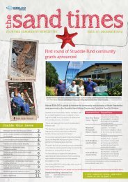
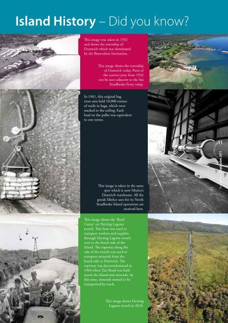
Island History – Did you know?<br />
This image was taken in 1932<br />
and shows the township of<br />
Dunwich which was dominated<br />
by the Benevolent Institution.<br />
This image shows the township<br />
of Dunwich today. Parts of<br />
the convict jetty from 1932<br />
can be seen adjacent to the Sea<br />
Stradbroke Ferry ramp.<br />
In 1961, this original bag<br />
store area held 10,000 tonnes<br />
of rutile in bags, which were<br />
stacked to the ceiling. Each<br />
load on the pallet was equivalent<br />
to one tonne.<br />
11<br />
This image is taken in the same<br />
spot which is now Sibelco’s<br />
Dunwich warehouse. All the<br />
goods Sibelco uses for its North<br />
Stradbroke Island operations are<br />
received here.<br />
The <strong>Sand</strong> <strong>Times</strong> September 2011<br />
This image shows the ‘Reed<br />
Cutter’ on Herring Lagoon<br />
trench. This boat was used to<br />
transport workers and supplies<br />
through Herring Lagoon trench<br />
over to the beach side of the<br />
Island. The ropeway along the<br />
side of the trench was used to<br />
transport minerals from the<br />
beach side to Dunwich. The<br />
ropeway was decommissioned in<br />
1964 when Tazi Road was built<br />
across the Island and minerals. At<br />
this time, minerals started to be<br />
transported by truck.<br />
This image shows Herring<br />
Lagoon trench in 2010.