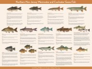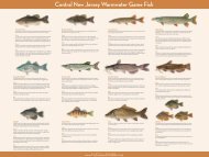
New Jersey
Deer Hunting Season - State of New Jersey
Deer Hunting Season - State of New Jersey

You also want an ePaper? Increase the reach of your titles
YUMPU automatically turns print PDFs into web optimized ePapers that Google loves.
Deer Management Zone<br />
Boundary Descriptions<br />
(continued from page 39)<br />
River to its intersection with the Garden State Parkway, the point of beginning.<br />
The Edwin B. Forsythe National Wildlife Refuge (Zones 56 and 57), the Atlantic<br />
County Park System (Zone 61) and the lands (excluding Laurel Memorial Park<br />
Cemetery), roads, right of ways and easements within the contiguous boundary<br />
of the Federal Aviation Administration William J. Hughes Technical Center<br />
(Zone 66) are excluded from Zone 42.<br />
Zone 43: That portion of Cumberland County lying within a continuous line<br />
beginning at the intersection of Buckshutem Rd. (County Rd. 670) and Cedarville<br />
Rd. (County Rd. 610); then southwest on Cedarville Rd. to its intersection with<br />
<strong>New</strong>port Centre Grove Rd. (County Rd. 629); then southwest on <strong>New</strong>port<br />
Centre Grove Rd. to its intersection with the Central Railroad of <strong>New</strong> <strong>Jersey</strong><br />
(C.R.R.N.J.); then east on the C.R.R.N.J. line to its intersection with Haleyville<br />
Rd. (County Rd. 676) at Mauricetown Station; then east on Haleyville Rd. to its<br />
intersection with the Maurice River at Mauricetown; then north along the west<br />
bank of the Maurice River to the north bank of Buckshutem Creek at Laurel<br />
Lake; then west along the north bank of Buckshutem Creek to Buckshutem<br />
Rd.; then northwest on Buckshutem Rd. to its intersection with Cedarville Rd.,<br />
the point of beginning.<br />
Zone 44: Not designated.<br />
Zone 45: That portion of Cumberland, Atlantic and Cape May counties<br />
lying within a continuous line beginning at the intersection of Broad St. (Rt.<br />
552 spur) and Delsea Drive (Rt. 47); then northeast along Rt. 552 spur to Rt. 552;<br />
then continuing northeast along Rt. 552 to its intersection with the Tuckahoe<br />
River at Milmay; then south along the west bank of the Tuckahoe River to<br />
its intersection with Rt. 49 at Hunter’s Mill; then southeast on Rt. 49 to its<br />
intersection with Rt. 548; then west on Rt. 548 to its intersection with Delsea<br />
Drive (Rt. 47) and the Manumuskin River in Port Elizabeth; then west along<br />
the south bank of Manumuskin River to its intersection with the Maurice<br />
River; then north along the east bank of the Maurice River to its intersection<br />
with Rt. 49 in Millville; then east on Rt. 49 to its intersection with Delsea Drive<br />
(Rt. 47); then north on Rt. 47 to its intersection with Broad St. (Rt. 552 spur),<br />
the point of beginning.<br />
Zone 46: That portion of Atlantic County lying within a continuous line<br />
beginning at the intersection of Rt. 49 and the Tuckahoe River at Hunter’s Mill;<br />
then southeast along Rt. 49 to its intersection with the Tuckahoe River and<br />
the Atlantic-Cape May County line at Head of River; then eastward along the<br />
north bank of the Tuckahoe River to Great Egg Harbor Bay and the Egg Harbor<br />
Township line on the Egg Harbor River; then northwest along the west bank<br />
of the Egg Harbor River to its intersection with Rt. 40 at Mays Landing; then<br />
west on Rt. 40 to its intersection with Estell Ave; then south on Estell Ave. to<br />
its intersection with Rt. 552 then southwest on Rt. 552 to its intersection with<br />
the Tuckahoe River at Milmay; then south along the east bank of the Tuckahoe<br />
River to its intersection with Rt. 49 at Hunter’s Mill the point of beginning. The<br />
Atlantic County Park System (Zone 61) is excluded from Zone 46.<br />
Zone 47: That portion of Gloucester, Atlantic and Cumberland counties<br />
lying within a continuous line beginning at the intersection of Rts. 47 and 40 at<br />
Malaga; then southeast on Rt. 40 to its intersection with Estell Ave.; then south<br />
on Estell Ave to its intersection with Rt. 552; then southwest on Rt. 552 to spur<br />
552; then west on spur 552 to its intersection with Rt. 47 at Millville; then north<br />
on Rt. 47 to Malaga, the point of beginning.<br />
Zone 48: That portion of Burlington County lying within a continuous<br />
line beginning at the intersection of the <strong>New</strong> <strong>Jersey</strong> Turnpike and Rt. 38 near<br />
Moorestown; then east along Rt. 38 to its intersection with Rt. 530; then east<br />
along Rt. 530 along the Pemberton by-pass to its intersection with the southern<br />
boundary of Fort Dix Military Reservation; then northward along the western<br />
Fort Dix boundary to its intersection with County Rd. 670; then east on County<br />
Rd. 670 to its intersection with Rt. 545 at Wrightstown; then northwest on Rt.<br />
545 which becomes Farnsworth Ave.; then continuing northwest on Farnsworth<br />
Ave. to its intersection with W. Burlington St.; then southwest on W. Burlington<br />
St. to its intersection with Interstate 295; then north on Interstate 295 to its<br />
intersection with Crosswicks Creek at Bordentown; then west along the<br />
south bank of Crosswicks Creek to its intersection with the Delaware River at<br />
Bordentown; then southwest along the east bank of the Delaware River to Rt.<br />
541 at the City of Burlington; then southeast along Rt. 541 to its intersection<br />
with Interstate 295; then southwest along Interstate 295 to its intersection<br />
with Rancocas Creek; then east along Rancocas Creek to its intersection with<br />
the <strong>New</strong> <strong>Jersey</strong> Turnpike; then southwest along the <strong>New</strong> <strong>Jersey</strong> Turnpike to<br />
its intersection with Rt. 38, the point of beginning. <strong>New</strong> Bold and Burlington<br />
Islands lying in the Delaware River are in this zone.<br />
Zone 49: That portion of Gloucester, Camden and Burlington counties<br />
lying within a continuous line beginning at the mouth of Mantua Creek on<br />
the Delaware River; then northeast along the east bank of the Delaware River<br />
to Rt. 541 at the City of Burlington; then southeast along Rt. 541 to its intersection<br />
with Interstate 295; then southwest along Interstate-295 to its intersection<br />
with Rancocas Creek; then east along the Rancocas Creek to its intersection<br />
with the <strong>New</strong> <strong>Jersey</strong> Turnpike; then southwest along the <strong>New</strong> <strong>Jersey</strong> Turnpike<br />
to its intersection with Rt. 73; then south along Rt. 73 to its intersection with<br />
County Rd. 689 (Cross Keys Rd.) at Berlin; then southwest along County Rd.<br />
689 to its intersection with County Rd. 688 Turnersville-Hickstown Rd.);<br />
then west along County Rd. 688 to its intersection with County Rd. 705; then<br />
northwest along County Rd. 705 (County House Rd.) to its intersection with<br />
County Rd. 635 (Grenlode-Hurfville Rd.); then southwest on County Rd. 635<br />
to its intersection with Mantua Creek; then northwest along Mantua Creek to<br />
its mouth at the Delaware River, the point of beginning. Petty Island lying in<br />
the Delaware River is in this zone.<br />
Zone 50: That portion of Monmouth and Middlesex counties lying within<br />
a continuous line beginning at the intersection of the <strong>New</strong> <strong>Jersey</strong> Turnpike and<br />
Rt. 522 near Jamesburg; then southeast on Rt. 522 to the intersection with Rt.<br />
537 at Freehold; then southwest on Rt. 537 to the intersection with business Rt.<br />
33; then east on Rt. 33 to the intersection with the western edge of the fenced<br />
boundary of the Earle Naval Weapons Depot; then north and east along the fenced<br />
boundary of the Earle Depot to the intersection of County Rt. 38 (Wayside Rd.)<br />
and Rt. 547 at the most eastern point of the fenced boundary of Naval Weapons<br />
Station-Earle; then northeast on Rt. 547 to the intersection with the Garden State<br />
Parkway; then north on the Garden State parkway to the intersection with Rt.<br />
36 near Eatontown; then east on Rt. 36 to the Atlantic Ocean; then north along<br />
the Atlantic coastline to the Raritan Bay; then south and west along the southern<br />
shore of Raritan Bay to the Raritan River; then continuing west along the south<br />
bank of the Raritan River to the intersection with the <strong>New</strong> <strong>Jersey</strong> Turnpike;<br />
then southwest along the <strong>New</strong> <strong>Jersey</strong> Turnpike to the intersection with Rt. 522,<br />
the point of beginning. Monmouth Battlefield State Park (Zone 64), and Naval<br />
Weapons Station Earle (Zones 39 and 40), are excluded from this zone.<br />
Zone 51: That portion of Monmouth and Ocean counties lying within<br />
a continuous line beginning at the intersection of Rt. 547 and Rt. 571 near<br />
Lakehurst; then southeast along Rt. 571 to the intersection with the Garden<br />
State Parkway; then south on the Garden State Parkway to its intersection with<br />
Rt. 72 near Manahawkin; then east along Rt. 72 to the Atlantic Ocean at Ship<br />
Bottom; then north along the Atlantic coastline to the intersection with Rt. 36<br />
in Long Branch; then west on Rt. 36 to the intersection with the Garden State<br />
Parkway near Eatontown; then south on the parkway to the intersection with<br />
547; then south on Rt. 547 to the intersection with county Rt. 38 (Wayside Rd.) at<br />
the eastern fenced boundary of Naval Weapons Station-Earle; then south along<br />
the eastern fenced boundary of Naval Weapons Station-Earle to the intersection<br />
with Rt. 34; then south on Rt. 34 to the intersection with Tinton Falls Rd. and<br />
Rt. 33; then south on Tinton Falls Rd. to the intersection with Rt. 547 (Asbury S<br />
40 | <strong>New</strong> <strong>Jersey</strong> Fish & Wildlife Digest Buy your license or permit online at August 2010<br />
2010 Hunting and Trapping Issue NJFishandWildlife.com