

CONSERVATION
ARC_7_1_Mexico_Issue_Complete_Issue
ARC_7_1_Mexico_Issue_Complete_Issue

Create successful ePaper yourself
Turn your PDF publications into a flip-book with our unique Google optimized e-Paper software.
Alvarado-Díaz et al.<br />
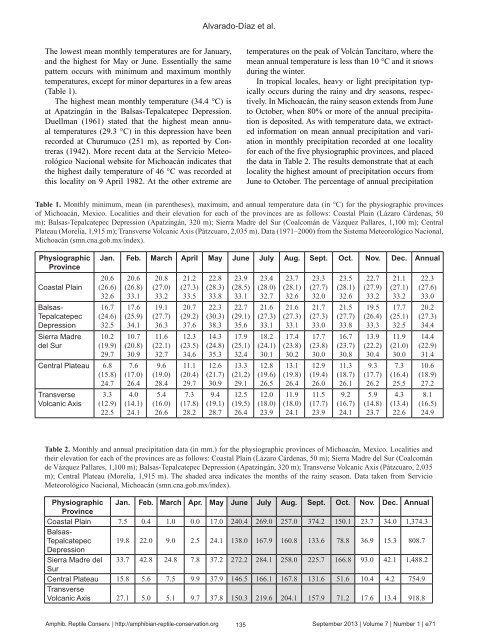
The lowest mean monthly temperatures are for January,<br />
and the highest for May or June. Essentially the same<br />
pattern occurs with minimum and maximum monthly<br />
temperatures, except for minor departures in a few areas<br />
(Table 1).<br />
The highest mean monthly temperature (34.4 °C) is<br />
at Apatzingán in the Balsas-Tepalcatepec Depression.<br />
Duellman (1961) stated that the highest mean annual<br />
temperatures (29.3 °C) in this depression have been<br />
recorded at Churumuco (251 m), as reported by Contreras<br />
(1942). More recent data at the Servicio Meteorológico<br />
Nacional website for Michoacán indicates that<br />
the highest daily temperature of 46 °C was recorded at<br />
this locality on 9 April 1982. At the other extreme are<br />
temperatures on the peak of Volcán Tancítaro, where the<br />
mean annual temperature is less than 10 °C and it snows<br />
during the winter.<br />
In tropical locales, heavy or light precipitation typically<br />
occurs during the rainy and dry seasons, respectively.<br />
In Michoacán, the rainy season extends from June<br />
to October, when 80% or more of the annual precipitation<br />
is deposited. As with temperature data, we extracted<br />
information on mean annual precipitation and variation<br />
in monthly precipitation recorded at one locality<br />
for each of the five physiographic provinces, and placed<br />
the data in Table 2. The results demonstrate that at each<br />
locality the highest amount of precipitation occurs from<br />
June to October. The percentage of annual precipitation<br />
Table 1. Monthly minimum, mean (in parentheses), maximum, and annual temperature data (in °C) for the physiographic provinces<br />
of Michoacán, Mexico. Localities and their elevation for each of the provinces are as follows: Coastal Plain (Lázaro Cárdenas, 50<br />
m); Balsas-Tepalcatepec Depression (Apatzingán, 320 m); Sierra Madre del Sur (Coalcomán de Vázquez Pallares, 1,100 m); Central<br />
Plateau (Morelia, 1,915 m); Transverse Volcanic Axis (Pátzcuaro, 2,035 m). Data (1971–2000) from the Sistema Meteorológico Nacional,<br />
Michoacán (smn.cna.gob.mx/index).<br />
Physiographic<br />
Province<br />
Coastal Plain<br />
Balsas-<br />
Tepalcatepec<br />
Depression<br />
Sierra Madre<br />
del Sur<br />
Jan. Feb. March April May June July Aug. Sept. Oct. Nov. Dec. Annual<br />
20.6<br />
(26.6)<br />
32.6<br />
16.7<br />
(24.6)<br />
32.5<br />
10.2<br />
(19.9)<br />
29.7<br />
Central Plateau 6.8<br />
(15.8)<br />
24.7<br />
Transverse<br />
Volcanic Axis<br />
3.3<br />
(12.9)<br />
22.5<br />
20.6<br />
(26.8)<br />
33.1<br />
17.6<br />
(25.9)<br />
34.1<br />
10.7<br />
(20.8)<br />
30.9<br />
7.6<br />
(17.0)<br />
26.4<br />
4.0<br />
(14.1)<br />
24.1<br />
20.8<br />
(27.0)<br />
33.2<br />
19.1<br />
(27.7)<br />
36.3<br />
11.6<br />
(22.1)<br />
32.7<br />
9.6<br />
(19.0)<br />
28.4<br />
5.4<br />
(16.0)<br />
26.6<br />
21.2<br />
(27.3)<br />
33.5<br />
20.7<br />
(29.2)<br />
37.6<br />
12.3<br />
(23.5)<br />
34.6<br />
11.1<br />
(20.4)<br />
29.7<br />
7.3<br />
(17.8)<br />
28.2<br />
22.8<br />
(28.3)<br />
33.8<br />
22.3<br />
(30.3)<br />
38.3<br />
14.3<br />
(24.8)<br />
35.3<br />
12.6<br />
(21.7)<br />
30.9<br />
9.4<br />
(19.1)<br />
28.7<br />
23.9<br />
(28.5)<br />
33.1<br />
22.7<br />
(29.1)<br />
35.6<br />
17.9<br />
(25.1)<br />
32.4<br />
13.3<br />
(21.2)<br />
29.1<br />
12.5<br />
(19.5)<br />
26.4<br />
23.4<br />
(28.0)<br />
32.7<br />
21.6<br />
(27.3)<br />
33.1<br />
18.2<br />
(24.1)<br />
30.1<br />
12.8<br />
(19.6)<br />
26.5<br />
12.0<br />
(18.0)<br />
23.9<br />
23.7<br />
(28.1)<br />
32.6<br />
21.6<br />
(27.3)<br />
33.1<br />
17.4<br />
(23.8)<br />
30.2<br />
13.1<br />
(19.8)<br />
26.4<br />
11.9<br />
(18.0)<br />
24.1<br />
23.3<br />
(27.7)<br />
32.0<br />
21.7<br />
(27.3)<br />
33.0<br />
17.7<br />
(23.8)<br />
30.0<br />
12.9<br />
(19.4)<br />
26.0<br />
11.5<br />
(17.7)<br />
23.9<br />
23.5<br />
(28.1)<br />
32.6<br />
21.5<br />
(27.7)<br />
33.8<br />
16.7<br />
(23.7)<br />
30.8<br />
11.3<br />
(18.7)<br />
26.1<br />
9.2<br />
(16.7)<br />
24.1<br />
22.7<br />
(27.9)<br />
33.2<br />
19.5<br />
(26.4)<br />
33.3<br />
13.9<br />
(22.2)<br />
30.4<br />
9.3<br />
(17.7)<br />
26.2<br />
5.9<br />
(14.8)<br />
23.7<br />
21.1<br />
(27.1)<br />
33.2<br />
17.7<br />
(25.1)<br />
32.5<br />
11.9<br />
(21.0)<br />
30.0<br />
7.3<br />
(16.4)<br />
25.5<br />
4.3<br />
(13.4)<br />
22.6<br />
22.3<br />
(27.6)<br />
33.0<br />
20.2<br />
(27.3)<br />
34.4<br />
14.4<br />
(22.9)<br />
31.4<br />
10.6<br />
(18.9)<br />
27.2<br />
8.1<br />
(16.5)<br />
24.9<br />
Table 2. Monthly and annual precipitation data (in mm.) for the physiographic provinces of Michoacán, Mexico. Localities and<br />
their elevation for each of the provinces are as follows: Coastal Plain (Lázaro Cárdenas, 50 m); Sierra Madre del Sur (Coalcomán<br />
de Vázquez Pallares, 1,100 m); Balsas-Tepalcatepec Depression (Apatzingán, 320 m); Transverse Volcanic Axis (Pátzcuaro, 2,035<br />
m); Central Plateau (Morelia, 1,915 m). The shaded area indicates the months of the rainy season. Data taken from Servicio<br />
Meteorológico Nacional, Michoacán (smn.cna.gob.mx/index).<br />
Physiographic Jan. Feb. March Apr. May June July Aug. Sept. Oct. Nov. Dec. Annual<br />
Province<br />
Coastal Plain 7.5 0.4 1.0 0.0 17.0 240.4 269.0 257.0 374.2 150.1 23.7 34.0 1,374.3<br />
Balsas-<br />
Tepalcatepec 19.8 22.0 9.0 2.5 24.1 138.0 167.9 160.8 133.6 78.8 36.9 15.3 808.7<br />
Depression<br />
Sierra Madre del 33.7 42.8 24.8 7.8 37.2 272.2 284.1 258.0 225.7 166.8 93.0 42.1 1,488.2<br />
Sur<br />
Central Plateau 15.8 5.6 7.5 9.9 37.9 146.5 166.1 167.8 131.6 51.6 10.4 4.2 754.9<br />
Transverse<br />
Volcanic Axis 27.1 5.0 5.1 9.7 37.8 150.3 219.6 204.1 157.9 71.2 17.6 13.4 918.8<br />
Amphib. Reptile Conserv. | http://amphibian-reptile-conservation.org<br />
135<br />
September 2013 | Volume 7 | Number 1 | e71