

for Dorset
Dorset_Book_Sept15-WEB Unlocked V1.2 X53 Correction
Dorset_Book_Sept15-WEB Unlocked V1.2 X53 Correction

You also want an ePaper? Increase the reach of your titles
YUMPU automatically turns print PDFs into web optimized ePapers that Google loves.
X51<br />
Mansell<br />
Square<br />
<strong>Dorset</strong><br />
County Hospital,<br />
Bridport Road<br />
Dorchester<br />
Top ‘o Town<br />
Museum<br />
X51 to Bridport,<br />
Lyme Regis<br />
and Axminster<br />
<strong>Dorset</strong><br />
County<br />
Hospital<br />
10.X51<br />
Trinity Street<br />
10<br />
X51<br />
X51<br />
Acland Road<br />
X53<br />
8<br />
X53<br />
Meadow<br />
Close<br />
X53 to Bridport,<br />
Lyme Regis<br />
and Exeter<br />
Knights in the Bottom<br />
Chickerell<br />
Turks Head<br />
Budmouth<br />
Technology<br />
College<br />
Chickerell<br />
Glennie Way<br />
8<br />
8.X53<br />
3<br />
Marquis<br />
of Granby<br />
6<br />
Here<strong>for</strong>d<br />
Road<br />
3<br />
Fiveways<br />
3<br />
Corporation<br />
Road<br />
Westham<br />
Admiral Hardy<br />
10<br />
Brewery<br />
Square<br />
Tesco<br />
Bottom of<br />
Ridgeway Hill<br />
Broadwey<br />
Wey Valley School<br />
X51<br />
Dorchester South<br />
Rail Station<br />
Littlemoor<br />
Shopping<br />
Centre<br />
Pye Hill<br />
2<br />
Cinder<br />
Path<br />
Littlemoor<br />
Louviers Road<br />
2<br />
2<br />
10<br />
Squires Knapp<br />
Seven Acres<br />
Chalbury<br />
Corner<br />
Weymouth<br />
Bay Haven<br />
Overcombe Corner<br />
Manor Roundabout<br />
Lodmoor Country Park<br />
Lodmoor Hill Shops<br />
Melcombe Avenue<br />
Weymouth College<br />
4.4A<br />
Dorchester Road1<br />
X53<br />
Abbotsbury 3.8<br />
Road<br />
X53<br />
3 .8<br />
Weymouth<br />
Rock<br />
X53<br />
Town Centre<br />
Hotel<br />
(see next page <strong>for</strong> details)<br />
ASDA<br />
6<br />
1<br />
4<br />
4A<br />
X53<br />
4.4A<br />
X53<br />
4<br />
Preston<br />
Spice Ship<br />
Seaview Haven<br />
Holiday Park<br />
4A<br />
Sutton<br />
Poyntz<br />
X53 to<br />
Wareham<br />
and Poole<br />
Lanehouse<br />
Rodwell Road/<br />
Rodwell Avenue<br />
6<br />
Buxton Road/<br />
Clearmount Road<br />
All Saints Church<br />
Buxton Road<br />
Wyke Regis<br />
Walker Crescent<br />
Wyke<br />
High Street<br />
Foords Corner<br />
1<br />
Wyke Regis Smugglers<br />
6<br />
Ferrybridge<br />
Victoria Square<br />
National Sailing Academy<br />
6<br />
1<br />
Fortuneswell<br />
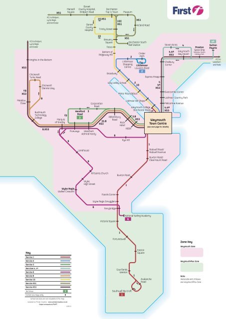
Zone Key<br />
Key<br />
Easton<br />
Square<br />
Weymouth Zone<br />
Service 1<br />
Service 2<br />
Service 3<br />
WeymouthPlus Zone<br />
Services 4, 4 A<br />
Service 6<br />
Service 8<br />
Service 10<br />
Service X51<br />
Service X53<br />
Terminus<br />
Certain journeys only<br />
3<br />
Courtlands<br />
Weston<br />
Southwell Rip Croft<br />
1<br />
1<br />
Avalanche<br />
Road<br />
Note:<br />
Waterside and Littlesea<br />
are WeymouthPlus Zone<br />
School services are not included on this map<br />
Updated by Pindar Creative www.pindarcreative.co.uk<br />
Original cartography by<br />
10.09.15