

GEOINT
1PP29u1
1PP29u1

Create successful ePaper yourself
Turn your PDF publications into a flip-book with our unique Google optimized e-Paper software.
» D.C. INNOVATION » FUTURE <strong>GEOINT</strong> LEADERS » INDOOR WAYFINDING<br />
2015 ISSUE 4<br />
THE OFFICIAL MAGAZINE<br />
OF THE UNITED STATES GEOSPATIAL INTELLIGENCE FOUNDATION<br />
THE<br />
<strong>GEOINT</strong><br />
REVOLUTION<br />
MULTIPLE<br />
TECHNOLOGIES<br />
ARE ADVANCING<br />
AND CONVERGING<br />
TO UNLEASH<br />
THE POWER OF<br />
GEOSPATIAL<br />
INTELLIGENCE
Manage your data.<br />
Discover answers.<br />
Make decisions.<br />
Analysts in today’s world are expected to have the right<br />
information at their fingertips to answer urgent questions at a<br />
moment’s notice. Jagwire ® allows analysts to spend less time<br />
searching for the right data and more time providing answers<br />
for time-critical operations. For more information visit<br />
exelisvis.com/Jagwire<br />
#IngenuitySquared<br />
harris.com<br />
©2015 Exelis Visual Information Solutions, Inc., a subsidiary of Harris Corporation.<br />
All rights reserved. All other marks are the property of their respective owners.<br />
Use of DoD imagery does not constitute or imply DoD endorsement.
CONTENTS 2015 ISSUE 4<br />
PHOTO COURTESY OF MAPBOX<br />
02 | VANTAGE POINT<br />
Steady growth for USGIF<br />
working groups and<br />
individual membership.<br />
04 | INTSIDER<br />
FAA grants UAV<br />
exemptions; international<br />
EO satellite launches;<br />
industry acquisitions.<br />
06 | IN MOTION<br />
NGA Xperience Directorate<br />
program updates;<br />
scholarship spotlight;<br />
lean innovation.<br />
10 | ELEVATE<br />
Northeastern University<br />
offers online geographic<br />
information technology<br />
program.<br />
PROFILES<br />
Learn more about<br />
the 2015 USGIF<br />
Scholarship Award<br />
winners.<br />
Features<br />
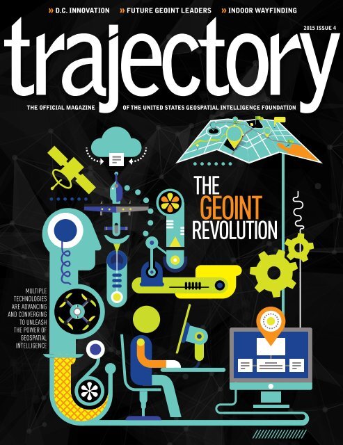
14 | THE <strong>GEOINT</strong> REVOLUTION<br />
Multiple technologies are advancing<br />
and converging to unleash the<br />
power of geospatial intelligence.<br />
By Keith J. Masback, CEO, USGIF<br />
20 | PROXIMATE PROSPERITY<br />
The D.C. area’s concentration of<br />
government, academia, and talent creates a<br />
unique advantage for startup innovators.<br />
By Melanie D.G. Kaplan<br />
26 | CARRYING ON THE TRADECRAFT<br />
Meet the 2015 USGIF Scholarship winners.<br />
TRAJECTORYMAGAZINE.com<br />
RESOURCES<br />
Charts, videos, and<br />
more on the <strong>GEOINT</strong><br />
Revolution.<br />
Mapbox team members<br />
gather for a meeting in<br />
the “garage.” Mapbox<br />
is one of the D.C. area’s<br />
fastest growing geospatial<br />
innovators.<br />
12 | COMMON GROUND<br />
New Geospatial and Remote<br />
Sensing Law Working<br />
Group fosters collaboration.<br />
30 | MEMBERSHIP PULSE<br />
Intergraph Government<br />
Solutions introduces new<br />
geospatial cloud products.<br />
32 | NEED TO KNOW<br />
Indoor wayfinding brings<br />
location awareness in from<br />
the elements.<br />
34 | HORIZONS<br />
Reading List; Peer Intel;<br />
USGIF Events Calendar.<br />
36 | APERTURE<br />
Revisiting New Orleans<br />
10 years after Hurricane<br />
Katrina.<br />
IMAGERY<br />
Hurricane<br />
Katrina and New<br />
Orleans: before,<br />
after, and today.<br />
TRJ-033
VANTAGE POINT<br />
A DYNAMIC DISCIPLINE<br />
The days after Labor Day in the D.C. area are always challenging as vacations end, college<br />
students return, and the local K-12 schools are back in session. It’s a traffic nightmare, and<br />
those of us who live and work in the region know getting from one place to another takes even<br />
longer than usual. So, it’s even more gratifying to see the daily flow in and out of the USGIF<br />
offices by our various working groups and committees, with dedicated volunteers making time<br />
in their schedules to contribute to the work of the Foundation and to the greater good of the<br />
<strong>GEOINT</strong> Community.<br />
Our working groups have steadily grown to be an important action arm of the Foundation.<br />
They are initiated and managed by member volunteers with the support of our full-time staff.<br />
This model flourished in the past 18 months thanks in<br />
part to Carrie Drake, who was the single point of entry<br />
for the working group chairs to access anything they<br />
needed from USGIF staff. Carrie developed a manual<br />
for the chairs, held plenary meetings to share best<br />
practices, and worked diligently to normalize the working<br />
group administration and structure. Carrie recently<br />
departed the Foundation after eight years to accept a<br />
position with a USGIF member company, and she will<br />
be missed. We will continue to build upon the legacy of Carrie’s hard work.<br />
Two great examples of relatively new working groups gaining considerable traction are the<br />
SmallSat Working Group and the Geospatial and Remote Sensing Law Working Group. Both<br />
have worked with USGIF staff to plan workshops for 2015 <strong>GEOINT</strong> Community Week in mid-<br />
November. These workshops follow in the tradition of superb events previously developed by the<br />
Commercial Synthetic Aperture Radar, Activity-Based<br />
Intelligence, Electro-Optical, and Africa working<br />
groups. Since the working groups are dynamic in<br />
nature, some will endure and some will inevitably<br />
become inactive, even as others are stood up.<br />
Speaking of dynamism, for the cover story in this<br />
issue of trajectory, I’ve attempted to capture the essence<br />
of a presentation I’ve given at conferences and on<br />
campuses throughout 2015 regarding the advent of the<br />
<strong>GEOINT</strong> Revolution. I intend for the article to serve as<br />
a starting point for discussion across our Community.<br />
We’re gratified by the tremendous<br />
support we’ve experienced for our<br />
new Individual Membership program,<br />
and we recognize the responsibility<br />
that accrues to the staff based on<br />
our membership growth.<br />
I hope you’ll find the article thought provoking because it’s incumbent upon us to get out ahead of<br />
this revolution, as opposed to being dragged behind it.<br />
Our second feature provides a glimpse into the DC-area startup scene, with some great exemplars<br />
from the <strong>GEOINT</strong> Community. Finally, we’ve included a snapshot of each of USGIF’s<br />
2015 scholarship awardees. An exciting milestone lies ahead next year when we will eclipse $1<br />
million in scholarships awarded by the Foundation in the last decade.<br />
I look forward to seeing you at one of our upcoming events, at the USGIF offices, and on our<br />
ever-growing membership list. We’re gratified by the tremendous support we’ve experienced for<br />
our new Individual Membership program, and we recognize the responsibility that accrues to the<br />
staff based on our membership growth. USGIF will remain an innovative, learning organization<br />
focused on providing significant value to our individual and organizational members, and to the<br />
ever-expanding <strong>GEOINT</strong> Community.<br />
USGIF CHAIRMAN OF THE BOARD<br />
The Honorable Jeffrey K. Harris<br />
USGIF CEO AND PUBLISHER<br />
Keith J. Masback<br />
EXECUTIVE EDITOR<br />
Jordan Fuhr<br />
jordan.fuhr@usgif.org<br />
MANAGING EDITOR<br />
Kristin Quinn<br />
kristin.quinn@usgif.org<br />
EDITOR<br />
Brad Causey<br />
bcausey@glcdelivers.com<br />
ART DIRECTOR<br />
Gretchen Kirchner Rund<br />
grund@glcdelivers.com<br />
ASSISTANT EDITOR<br />
Lindsay Tilton Mitchell<br />
lindsay.mitchell@usgif.org<br />
AD SALES<br />
Jeff Ley<br />
jeff.ley@usgif.org<br />
Trajectory is the official magazine<br />
of the United States Geospatial<br />
Intelligence Foundation (USGIF).<br />
HOW TO REACH US<br />
LETTERS AND COMMENTS<br />
For comments on trajectory, contact<br />
trajectory@usgif.org.<br />
SUBSCRIPTIONS<br />
For information on subscribing to<br />
trajectory, sign up for free at<br />
trajectorymagazine.com.<br />
USGIF MEMBERSHIP<br />
For more information on USGIF<br />
or becoming a USGIF member,<br />
contact 888-MY-USGIF<br />
(888-698-7443).<br />
TWITTER<br />
@trajectorymag<br />
PUBLICATION MANAGEMENT<br />
KEITH J. MASBACK | CEO, USGIF<br />
@geointer<br />
847-205-3000 | GLCDELIVERS.COM<br />
2 | TRAJECTORYMAGAZINE.COM ll 2015 ISSUE 4
As world-class experts in geospatial-<br />
intelligence, Ball Aerospace transforms<br />
data into dynamic, predictive, interactive<br />
intelligence across all <strong>GEOINT</strong> missions<br />
and communities. From persistent data<br />
collection hardware to advanced<br />
processing and exploitation capabilities,<br />
we provide innovative, integrated<br />
solutions for the nation and our world.<br />
www.ballaerospace.com
N E W S U P D A T E S A N D H I G H L I G H T S<br />
INDUSTRY ACQUISITIONS<br />
FAA GRANTS 1,000 UAV EXEMPTIONS<br />
In August, the Federal Aviation Administration<br />
(FAA) granted 1,000 Section 333 exemptions<br />
allowing commercial businesses to fly unmanned<br />
aerial vehicles (UAVs), bringing the total number<br />
of such exemptions to 1,008. Many of the grants<br />
allow aerial filming for uses such as motion<br />
picture production, precision agriculture, real<br />
estate photography, and inspecting infrastructure<br />
such as power distribution towers, railroads, and<br />
bridges. The move represents the FAA’s efforts<br />
to streamline the process for operators to access<br />
national airspace.<br />
In September, Apple acquired San-Francisco-based<br />
mapping analytics company Mapsense. Mapsense is<br />
equipped to analyze billions of digitally connected devices<br />
streaming location data. The MapSense team will join<br />
Apple’s headquarters in Cupertino, Calif.<br />
In July, Planet Labs entered into a definitive agreement<br />
to purchase Canada-based BlackBridge, including<br />
its RapidEye satellite constellation. This acquisition is a<br />
strategic move by Planet Labs to expand quickly into new<br />
segments and gain access to a robust imagery archive.<br />
With BlackBridge, Planet Labs has access to a network<br />
of more than 100 distribution channels and customers<br />
globally, as well as a six-year archive of global commercial<br />
imagery totaling six billion square kilometers at fivemeter<br />
resolution.<br />
In August, Nokia sold its digital mapping unit Here<br />
for approximately $3 billion to a trio of German automakers.<br />
The automakers, including Audi, BMW Group, and Daimler<br />
acquired Here to use for autonomous driving initiatives. The<br />
three automakers have taken equal share of the mapping<br />
unit and the transaction is expected to close by 2016.<br />
UrtheCast in July acquired earth observation business<br />
Deimos Imaging from Elecnor. This includes ownership<br />
and operation of the Deimos-1 and Deimos-2 satellites.<br />
The combination of UrtheCast and Deimos operations<br />
is expected to accelerate UrtheCast’s goals related to<br />
distribution, web platform development, and building out<br />
its constellation.<br />
Data analytics company Splunk procured security<br />
company Caspida for $190 million in July. Splunk will<br />
combine its machine data analysis to Caspida’s ability to<br />
detect malware inside corporate networks to create a better<br />
overall security product.<br />
In August, Accenture acquired D.C.-based cybersecurity<br />
company FusionX to further strengthen Accenture’s<br />
security practices and help clients assess their ability to<br />
protect against, detect, and respond to cyber attacks.<br />
CA Technologies signed a definitive agreement in<br />
August to procure Xceedium, an identity management<br />
solutions provider. The combination will reinforce CA’s<br />
leadership in identity management and offer customers<br />
a flexible approach to managing identity compliance<br />
and risk.<br />
More than<br />
680,000<br />
SOURCE:<br />
4 | TRAJECTORYMAGAZINE.COM ll 2015 ISSUE 4<br />
apps in the Apple App Store use location services<br />
as of 2014.<br />
APPLE WWDC 2014
PROCRASTINATION TOOLS<br />
IMAGE COURTESY OF SSEC<br />
HIMAWARI-8 DATA collected July 5–7, 2015, shows Typhoon Nangka as captured by all 16<br />
AHI channels.<br />
PERISCOPE<br />
Periscope allows smartphone users to explore the world<br />
in real time through someone else’s eyes. Use the live<br />
video streaming platform to record the places you go, view<br />
friends’ videos, and comment and ask questions.<br />
periscope.tv<br />
INTERNATIONAL EARTH OBSERVATION<br />
SATELLITE LAUNCHES<br />
A number of countries launched earth observation satellites during summer<br />
2015. The Sentinel-2A earth observation satellite, built by Airbus Defense<br />
and Space for the European Space Agency, was launched in June. The<br />
Sentinel 2 mission will contribute to<br />
the management of food security<br />
by providing information to the<br />
agricultural sector.<br />
Sentinel-2A model<br />
Five United Kingdom-built<br />
satellites were launched in July,<br />
making it the largest number of<br />
wholly British spacecraft to deploy<br />
in a single launch. Three of the<br />
satellites will be used to image the<br />
Earth and support disaster monitoring<br />
and relief, while the other two will test<br />
technologies for use on future spacecraft.<br />
The world’s first geostationary weather satellite capable of capturing<br />
images in full color began operation in July. Japan’s Himawari-8 can shoot 16<br />
different kinds of images every 10 minutes. During its first full day in operation,<br />
Himawari-8 captured imagery of Typhoons Chan-hom and Nangka spinning in<br />
the western Pacific Ocean.<br />
China plans to launch a commercial remote sensing satellite in October.<br />
Jilin-1 will provide photographs to commercial clients while helping with<br />
harvest assessment, geological disaster prevention, and resource surveys.<br />
IMAGE COURTESY OF RAMA/WIKIPEDIA<br />
MEERKAT<br />
Linked with Twitter, the<br />
Meerkat app allows iOS<br />
and Android users to share<br />
experiences by streaming live<br />
videos to their followers.<br />
meerkatapp.co<br />
MAPSTR<br />
Pinpoint all of your preferred<br />
restaurants and shops in one<br />
map with the smartphone app<br />
Mapstr. Type in the name of<br />
your favorite locations, add<br />
tags, and share with friends.<br />
mapstr.com<br />
97%<br />
7 billion mobile subscriptions, a penetration rate of , are projected by the end of 2015.<br />
SOURCE: INTERNATIONAL TELECOMMUNICATIONS UNION<br />
USGIF.ORG kk TRAJECTORY | 5
IN MOTION |<br />
WHAT WE DO<br />
USGIF SMALLSAT<br />
WORKING GROUP<br />
ATTENDS SMALL<br />
SATELLITE<br />
CONFERENCE<br />
USGIF’S DR. BABER SPEAKS AT<br />
NATIONAL GEOGRAPHY EDUCATION<br />
CONFERENCE<br />
USGIF Director of Academic Programs Dr. Maxwell Baber spoke on a panel at<br />
the 2015 National Council for Geographic Education Aug. 7. Baber discussed<br />
“<strong>GEOINT</strong> for the High School Classroom,” described classroom-ready exercises, and<br />
provided resources for the audience.<br />
USGIF FILE PHOTO<br />
In August, the USGIF<br />
SmallSat Working Group<br />
participated in a panel discussion<br />
during the Small Satellite<br />
Conference in Logan, Utah.<br />
Panelists included Rob Zitz, senior<br />
vice president and chief systems<br />
architect with Leidos; Dan Twomey,<br />
manager of engineering at NJVC; and<br />
Chris McCormick, chairman and CEO of PlanetiQ.<br />
The panel discussed the emerging and important role of<br />
SmallSats in the <strong>GEOINT</strong> Community. The working<br />
group is planning USGIF’s first SmallSat Workshop for<br />
Nov. 16-17 as part of 2015 <strong>GEOINT</strong> Community Week.<br />
SPOTLIGHT: USGIF SCHOLARSHIP RECIPIENT<br />
2014 USGIF SCHOLARSHIP recipient<br />
Megan Miller visited the National<br />
Oceanic and Atmospheric Administration<br />
building this summer while conducting<br />
research for her Ph.D. dissertation.<br />
2014 USGIF Scholarship recipient<br />
Megan Miller has always<br />
been interested in mathematics<br />
and analytics. After learning<br />
remote sensing and photogrammetry<br />
during her undergraduate<br />
studies and realizing its career<br />
opportunities, Miller knew it<br />
would be a good choice for her<br />
career path. Now, she is on her<br />
way toward achieving a Ph.D. in<br />
geomatics engineering at Purdue<br />
University.<br />
While earning her master’s<br />
degree in geomatics engineering<br />
at Purdue, Miller won a 2014<br />
USGIF Scholarship.<br />
“I learned about USGIF from<br />
my mentor Nathan Ovans,” she<br />
said. “He proposed the scholarship<br />
as a way to get involved and<br />
have exposure in the <strong>GEOINT</strong><br />
Community. The scholarship<br />
enabled me to attend the 2015<br />
American Society of Photogrammetry<br />
and Remote Conference,<br />
where I presented my research in one of the<br />
technical sessions.”<br />
Miller spent this summer interning at the<br />
National Geospatial-Intelligence Agency’s (NGA)<br />
Basic and Applied Research Office. She said<br />
her experience at NGA contributed to her Ph.D.<br />
research dissertation. Miller is studying algorithms<br />
and methodology that would enable digital<br />
surface model generation from low-altitude<br />
unmanned aerial vehicle imagery. The emphasis<br />
of her research is on maritime applications such<br />
as detection and safety of navigation.<br />
Miller also attended USGIF’s <strong>GEOINT</strong> 2015<br />
Symposium in June, which she said was a rewarding<br />
experience.<br />
“I benefited greatly from the keynote speakers<br />
on the direction and momentum of the <strong>GEOINT</strong><br />
Community,” Miller said. “The greatest benefit<br />
was from the interactions with peers and leaders<br />
who gave useful insight, and most importantly,<br />
vision for how to continue building an impactful<br />
skill set.”<br />
Miller is expecting to earn her Ph.D. in May<br />
2017. After graduating she hopes to become a<br />
full-time member of the intelligence and defense<br />
community.<br />
PHOTO COURTESY OF MEGAN MILLER<br />
6 | TRAJECTORYMAGAZINE.COM ll 2015 ISSUE 4
A CUSTOMER-CENTRIC NGA<br />
Justin Poole of NGA’s Xperience Directorate provides program updates<br />
WHAT WE DO | IN MOTION<br />
Justin Poole, director of the National Geospatial-Intelligence<br />
Agency’s (NGA) Xperience Directorate, discussed the agency’s<br />
new customer focus Sept. 8 at USGIF’s <strong>GEOINT</strong>eraction<br />
Tuesday networking event.<br />
Poole kicked off his speech by defining his emphasis on<br />
“customer centricity”—a philosophy by which the agency<br />
strives to provide not only what customers ask for, but what<br />
they need to accomplish their mission.<br />
“[NGA’s] Globe, Map of the World, IGAPP… those are just<br />
stuff,” Poole said. “It’s cool stuff and we’ve worked extremely<br />
hard on them, but at the end of the day we need to employ it<br />
in the manner that improves customer experience.”<br />
The Globe, NGA’s new unified web presence featuring<br />
geospatial content, tools, and services, provides context on<br />
global events and makes <strong>GEOINT</strong> more accessible for NGA<br />
customers, according to Poole. It features enterprise search,<br />
advanced storytelling via traditionally trained journalists, a<br />
map application program interface, an ecosystem navigation<br />
bar, and responsive mobile design.<br />
Poole went on to discuss NGA’s upcoming <strong>GEOINT</strong><br />
Services model. Set to launch in 2016, the <strong>GEOINT</strong> Services<br />
platform allows <strong>GEOINT</strong> producers and consumers<br />
to exchange geospatial content and services and provides<br />
on-demand access to geospatial, sensor,<br />
geo-referencing, enrichment, and<br />
processing services. Poole said GEO-<br />
INT Services would help bring more<br />
small businesses, niche companies,<br />
and academic partners into the NGA<br />
fold by starting the development<br />
process on the low side then moving<br />
capabilities to classified networks.<br />
Poole concluded with an update<br />
on NGA’s Innovative <strong>GEOINT</strong> Application<br />
Provider Program (IGAPP),<br />
which launched in May under a<br />
four-year contract with TASC. The<br />
program facilitates the delivery of applications to NGA’s GEO-<br />
INT App Store with TASC acting as an app broker, lowering<br />
the barrier to entry and significantly speeding up the process for<br />
delivering new apps to agency customers. Poole said NGA has<br />
already approved more than 200 vendors and encouraged the<br />
audience to submit app proposals and partner with NGA to help<br />
the agency more fully embrace “mobile first.”<br />
“[IGAPP] is an innovative, groundbreaking way to bring<br />
capability,” he said.<br />
JUSTIN POOLE,<br />
director of NGA’s<br />
Xperience Directorate,<br />
addressed the<br />
audience at USGIF’s<br />
<strong>GEOINT</strong>eraction<br />
Tuesday event in<br />
September.<br />
USGIF FILE PHOTO
IN MOTION |<br />
WHAT WE DO<br />
USGIF HOSTS NONPROFIT<br />
MANAGEMENT EXTERNS<br />
LEAN INNOVATION<br />
In August, USGIF hosted a nonprofit management externship for four<br />
Gettysburg College students. USGIF staff provided a day and a half of panel<br />
discussions and shadowing opportunities to help students learn about the roles<br />
of various departments within nonprofit organizations.<br />
USGIF FILE PHOTO<br />
PICTURED FROM LEFT TO RIGHT ARE: USGIF CEO Keith Masback, Gettysburg<br />
College students Margaret G. Czepiel and Lesley A. Rompalo, former USGIF Senior<br />
Manager for Volunteer Engagement Carrie Drake, and former USGIF Intern and<br />
Gettysburg College student Conor Barry.<br />
NGA-USGIF NEXTGEN<br />
TASKING INDUSTRY DAY<br />
Steve Blank, the father of Lean Startup, shared with<br />
industry and government how to innovate faster,<br />
cheaper, and better during a USGIF and OGSystems<br />
special presentation Aug. 14.<br />
Blank began his career in U.S. Air Force electronic<br />
warfare, then founded and sold eight tech companies,<br />
four of which went public. Now, as a retired serial<br />
entrepreneur-turned-educator, he is changing how<br />
startups are built and how entrepreneurship is taught.<br />
The National Science Foundation I-Corps adopted<br />
Blank’s Lean Launchpad<br />
methodology, and his work<br />
inspired the General Services<br />
Administration’s digital service<br />
agency 18F.<br />
According to Blank,<br />
innovation is not a noun or<br />
physical place—having an<br />
incubator, accelerator, or<br />
startup does not guarantee an<br />
organization is producing innovative thoughts and ideas.<br />
“I call this innovation theater,” Blank said. “It looks<br />
good. It’s great PR. But it doesn’t move the dial.”<br />
In outlining the Lean Startup methodology, which<br />
champions a more agile approach to innovation, Blank<br />
emphasized the importance of speed.<br />
“Our adversaries’ speed is a threat, but our speed<br />
potentially is mitigation,” he said.<br />
PHOTO COURTESY OF NGA<br />
USGIF FILE PHOTOS<br />
VISIT<br />
trajectorymagazine.<br />
com and search “Steve<br />
Blank” to watch a<br />
video of Blank’s full<br />
presentation.<br />
USGIF AND THE NATIONAL GEOSPATIAL-INTELLIGENCE AGENCY (NGA)<br />
co-hosted an NGA Operations Technology Solution Discovery Day at NGA Campus East<br />
Sept. 14. The unclassified event welcomed industry and academia to hear NGA leadership<br />
discuss the agency’s Next Generation Tasking Initiative and participate in Q&A discussions.<br />
In this photo, John Charles, NGA’s National <strong>GEOINT</strong> Officer for Commercial Imagery,<br />
addresses the audience. More than 300 people attended, and the event was broadcast live<br />
to NGA facilities around the country.<br />
8 | TRAJECTORYMAGAZINE.COM ll 2015 ISSUE 4
A new path to the future<br />
DELIVERING AWARENESS, INSIGHT<br />
AND UNDERSTANDING FROM A<br />
NEW PERSPECTIVE<br />
Leidos provides the next generation of Multi-Int, open<br />
source intelligence solutions preparing you for an<br />
increasingly complex and dynamic world.<br />
leidos.com/newpath<br />
©2015 Leidos. All Rights Reserved.
ELEVATE |<br />
ACADEMICS AND EDUCATION<br />
A NON-TRADITIONAL EDUCATION<br />
Northeastern University offers online geographic information technology program<br />
By Lindsay Tilton Mitchell<br />
PARTICIPANTS<br />
GATHER AROUND<br />
the computer of<br />
Sophia Liu, a research<br />
geographer with<br />
the U.S. Geological<br />
Survey, during a<br />
“Crisis Mapping<br />
for Humanitarian<br />
Action” education<br />
session hosted<br />
by Northeastern<br />
University at<br />
the <strong>GEOINT</strong> 2015<br />
Symposium.<br />
A<br />
PRIVATE RESEARCH<br />
INSTITUTION, Boston-based<br />
Northeastern University<br />
emphasizes experiential learning,<br />
or the integration of the<br />
classroom with the real world by engaging<br />
students in professional internships,<br />
research, and service projects around<br />
the world. Northeastern’s graduate<br />
geographic information technology<br />
(GIT) program within the university’s<br />
College of Professional Studies has<br />
thrived under such experiential learning<br />
initiatives.<br />
Since being awarded USGIF<br />
accreditation in September 2014 under<br />
the Foundation’s Collegiate Geospatial<br />
Intelligence Certificate Program, Dr.<br />
Cordula Robinson, associate teaching<br />
professor, said the GIT program has<br />
greatly benefited from the designation.<br />
“Northeastern has a robust, advanced<br />
online component,” Robinson said.<br />
“We’ve recently seen the field of<br />
<strong>GEOINT</strong> just explode and have seen a<br />
crowd drawn to our program.”<br />
One reason for the program’s<br />
popularity is the unique online element<br />
Robinson mentioned. Students have the<br />
option to either complete the program<br />
entirely online or partially online<br />
paired with brick-and-mortar classes<br />
at the Boston campus. The program<br />
is designed for working professionals<br />
seeking to expand their knowledge and<br />
advance their skills.<br />
From project management to<br />
database design, the program offers a<br />
range of courses for students to explore,<br />
as well as concentrations in geographic<br />
DR. CORDULA<br />
ROBINSON,<br />
associate teaching<br />
professor with<br />
Northeastern<br />
University’s<br />
geographic information<br />
technology program,<br />
presented a lightning<br />
talk focused on<br />
C4ISR during <strong>GEOINT</strong><br />
Foreword at <strong>GEOINT</strong><br />
2015.<br />
USGIF FILE PHOTOS<br />
10 | TRAJECTORYMAGAZINE.COM ll 2015 ISSUE 4
ACADEMICS AND EDUCATION | ELEVATE<br />
information systems and remote sensing.<br />
Approximately 350 students have<br />
graduated since the program launched<br />
in 2009—and are now employed across<br />
U.S. government, military and industry,<br />
in addition to a handful of graduates<br />
located internationally.<br />
“With the unleashed power of<br />
<strong>GEOINT</strong>, there’s a real need to make<br />
these skills more available so the workforce<br />
is prepared,” Robinson said.<br />
One Northeastern University student<br />
who enhanced his skills through the<br />
program is George “Stan” Bosarge, a<br />
senior research laboratory manager at<br />
the University of South Alabama’s Fisheries<br />
Ecology Lab. Bosarge completed<br />
the GIT program with a focus in remote<br />
sensing earlier this year, and was one<br />
of the first students to receive a USGIF<br />
<strong>GEOINT</strong> Certificate from Northeastern.<br />
Bosarge was also the recipient of the<br />
2015 USGIF Academic Research Award.<br />
“It was a very positive experience—<br />
the class participation in my mind was<br />
the best aspect because you’re engaged<br />
with the instructors and it’s more about<br />
application and discussion rather than<br />
learning the mechanics and assignments,”<br />
Bosarge said.<br />
U.S. Air Force Geospatial Intelligence<br />
Analyst Kevin Boyle was also one<br />
of the first students to achieve a USGIF<br />
<strong>GEOINT</strong> Certificate at Northeastern<br />
upon completion of the GIT program<br />
in June.<br />
“Having been in the military since 2008,<br />
the biggest advantage was seeing the other<br />
side of <strong>GEOINT</strong>, and being more exposed<br />
to commercial software,” Boyle said.<br />
“Bringing those skills and training back to<br />
the Air Force was a great bonus.”<br />
To showcase the GIT program,<br />
Northeastern had a strong presence at<br />
USGIF’s <strong>GEOINT</strong> 2015 Symposium in<br />
June. Not only did the university exhibit<br />
in the Symposium’s exhibit hall, but<br />
Northeastern faculty members also led<br />
training sessions on humanitarian crisis<br />
mapping and presented lightning talks<br />
“THE FACULTY LOVES<br />
SHARING THEIR<br />
EXPERTISE WITH<br />
STUDENTS AND—THIS<br />
YEAR, FOR THE FIRST<br />
TIME—<strong>GEOINT</strong> 2015<br />
ATTENDEES.”<br />
—Dr. Cordula Robinson, associate teaching<br />
professor, Northeastern University<br />
on both crisis mapping and C4ISR.<br />
“The faculty loves sharing their<br />
expertise with students and—this year,<br />
for the first time—<strong>GEOINT</strong> 2015<br />
attendees,” Robinson said. “It all ties<br />
back to Northeastern’s online experiential<br />
learning. We bring the best of what<br />
online education has to offer by fostering<br />
a powerful relationship between learning<br />
and working.”<br />
FIRST-OF-ITS-KIND<br />
Remote Sensing Textbook<br />
NOW AVAILABLE<br />
PHENOMENOLOGY • SENSORS • INTELLIGENCE APPLICATIONS<br />
“This book benchmarks the state of understanding so our next generation of engineers<br />
and scientists can innovate and advance intelligence tradecraft.”<br />
—Jeffrey K. Harris, Former Director of the National Reconnaissance Office<br />
“This text should be part of every <strong>GEOINT</strong> professional’s library and will readily serve<br />
as a superb basic or applied remote sensing reference.”<br />
—Keith J. Masback, CEO, United States Geospatial Intelligence Foundation<br />
“This book is an excellent reference for anyone working in the Intelligence Community.”<br />
—Hon. Jim Longley, Jr., Executive Director, Advanced Technical Intelligence Association<br />
ORDER HERE<br />
www.riversideresearch.org/textbook<br />
Scholarship Program<br />
Textbook proceeds will be donated to<br />
the Ken Miller Scholarship for Advanced<br />
Remote Sensing Applications.
COMMON GROUND |<br />
WORKING GROUPS & COMMITTEES<br />
KEEPING PACE WITH LAW AND POLICY<br />
USGIF’s new Geospatial and Remote Sensing Law Working Group aims to foster cross-education and<br />
collaboration among attorneys and policy-makers<br />
By Jim Hodges<br />
KEVIN POMFRET,<br />
executive director of<br />
The Centre for Spatial<br />
Law and Policy, and<br />
Cynthia Ryan, general<br />
counsel at the National<br />
Geospatial-Intelligence<br />
Agency, spoke about<br />
legal and policy<br />
trends in the <strong>GEOINT</strong><br />
Community on the<br />
Government Pavilion<br />
Stage at the <strong>GEOINT</strong><br />
2015 Symposium in<br />
June. Pomfret and Ryan<br />
co-chair USGIF’s new<br />
Geospatial and Remote<br />
Sensing Law Working<br />
Group.<br />
USGIF FILE PHOTO<br />
THE MOTTO in the office of<br />
National Geospatial-Intelligence<br />
Agency (NGA) General Counsel<br />
Cynthia Ryan is “Know the Law,<br />
Find a Way.” It’s a mantra easily<br />
transferable to USGIF’s Geospatial and<br />
Remote Sensing Law Working Group,<br />
which met for the first time July 12.<br />
Ryan co-chairs the group with Kevin<br />
Pomfret, founder and director of the<br />
Centre for Spatial Law and Policy.<br />
“We want to educate attorneys on legal<br />
issues, develop training on key legal issues<br />
on <strong>GEOINT</strong> for USGIF non-attorney<br />
members, and to develop a community<br />
of interest with lawyers to share information<br />
regarding geospatial law,” Ryan said,<br />
summarizing the objectives outlined in<br />
the working group’s charter.<br />
The group will initially include<br />
about 20 attorneys from across government<br />
and industry and at least one<br />
academic. This cross section of participants<br />
represents what Pomfret calls “the<br />
evolving geospatial ecosystem, where<br />
industry, government, and the crowd<br />
are both data providers and data users,<br />
almost simultaneously, and where the<br />
impact of regulation on one has a much<br />
broader impact on the entire ecosystem.”<br />
The working group is reaching out to<br />
members of USGIF’s Small Business and<br />
Small Satellite working groups to begin<br />
a dialogue and identify their concerns<br />
about geospatial law. It’s a way for the<br />
lawyers to hear from industry and communicate<br />
their understanding of ongoing<br />
regulation changes and court findings, as<br />
well as begin to interpret what they mean<br />
to the <strong>GEOINT</strong> Community.<br />
Driving the group is the understanding<br />
that technological development<br />
typically far outpaces the laws and policies<br />
that govern its use.<br />
“As we embark upon the <strong>GEOINT</strong><br />
revolution, the myriad technological<br />
advances related to location and remote<br />
sensing are significantly outpacing the<br />
development of associated policy and<br />
law,” said USGIF CEO Keith Masback.<br />
“Decisions are being made daily at all<br />
levels of government in the U.S. (and<br />
abroad), as courts set precedents gavel<br />
drop by gavel drop. As this group gets<br />
up and running, we think it will play a<br />
crucial role in organizing a more coherent<br />
way forward.”<br />
The group strives to ensure laws and<br />
policies are considered at the front end<br />
of innovation, however that goal isn’t<br />
always possible or practical.<br />
“The key for non-lawyers is to understand<br />
the legal issues that arise when<br />
you’re trying to conceptualize, develop,<br />
and deploy systems and data,” Ryan<br />
said. “There’s a whole host of issues<br />
12 | TRAJECTORYMAGAZINE.COM ll 2015 ISSUE 4
that industry needs to be aware of, legal<br />
issues that arise within government and<br />
companies in private industry as well.”<br />
Raising awareness becomes less of an<br />
issue as regulations and policies make<br />
their way through courts and legislatures.<br />
Reacting and conforming to new regulation<br />
is another matter.<br />
“We want to give enough knowledge<br />
about what the law is in particular areas<br />
so that if the geospatial professionals<br />
see something they have a concern<br />
about, they can spot it and also articulate<br />
it to their lawyer in a way that their<br />
lawyer can understand,” Pomfret said.<br />
“For the near-term, anyway, it’s going to<br />
be incumbent upon the professionals<br />
to identify some of these issues and<br />
explain their concerns to their lawyers<br />
so that they can both work through<br />
a solution.”<br />
In March, USGIF and Pomfret’s<br />
Centre for Spatial Law and Policy<br />
entered into a memorandum of agreement<br />
under which the Centre and<br />
“THERE’S A WHOLE HOST OF ISSUES THAT INDUSTRY<br />
NEEDS TO BE AWARE OF, LEGAL ISSUES THAT ARISE<br />
WITHIN GOVERNMENT AND COMPANIES IN PRIVATE<br />
INDUSTRY AS WELL.”<br />
—Cynthia Ryan, NGA General Counsel<br />
USGIF will educate the geospatial community<br />
on the unique legal and policy<br />
issues that impact the collection, use,<br />
storage, and distribution of geospatial<br />
information. USGIF and the Centre<br />
will, in addition to the creation of the<br />
Geospatial and Remote Sensing Law<br />
Working Group, develop training and<br />
education materials for <strong>GEOINT</strong> practitioners,<br />
host workshops, and further an<br />
understanding of geospatial and remote<br />
sensing law.<br />
The group’s work begins with an<br />
understanding that if the <strong>GEOINT</strong><br />
industry is going to continue advancing,<br />
the public perception of the technology<br />
must continue to evolve—with the help<br />
of lawyers.<br />
“We need to be involved with the<br />
agency or company at the time of<br />
conceptualization [of technology], or<br />
at least as early as possible, so that we<br />
can identify appropriate legal paths to<br />
accomplish the mission,” Ryan said.<br />
“Retrofitting to comply after the build<br />
[could cost] the organization financial<br />
and personnel resources or unacceptable<br />
risk of non-compliance.”<br />
BOSTON 978.526.4200 www.pbandw.com CHARLOTTE 704.358.8094
14 | TRAJECTORYMAGAZINE.COM ll 2015 ISSUE 4<br />
MULTIPLE<br />
TECHNOLOGIES<br />
ARE<br />
ADVANCING<br />
AND<br />
CONVERGING<br />
TO UNLEASH<br />
THE POWER OF<br />
GEOSPATIAL<br />
INTELLIGENCE.
the<br />
NAMEgeoiNt<br />
RATE LAM UT LIANDAN ISCIANTIOS EXPEDICI OMNIS<br />
EATESTE MODI DOLLORRO MAXIMAGNIMUS IL EATUR?<br />
BY<br />
BY KEITH J. MASBACK, CEO, USGIF<br />
Five years ago the United States Geospatial<br />
Intelligence Foundation (USGIF) and some of our<br />
members helped fund an innovative media project<br />
called “The Geospatial Revolution.” The video series,<br />
by Pennsylvania State University’s public broadcasting<br />
affiliate, chronicled how a number of elements were<br />
coinciding to create a revolution in geospatial technology<br />
and information.<br />
USGIF.ORG kk TRAJECTORY | 15
Today, we’re experiencing a similar<br />
convergence of technology swirling<br />
around this thing we call geospatial<br />
intelligence (<strong>GEOINT</strong>), a term coined<br />
by the U.S. government just 12 years<br />
ago. <strong>GEOINT</strong>—not to be confused<br />
with simply “geospatial”—is loosely<br />
defined as the derivation of information<br />
from imagery, geospatial data in all<br />
forms, and analytics. As the government<br />
defined and began shaping its<br />
approach to <strong>GEOINT</strong>, remote sensing<br />
and geospatial information were transforming<br />
in commercial areas even faster<br />
and with greater implications. Over the<br />
past 12 years, the concept of <strong>GEOINT</strong><br />
expanded beyond the national security<br />
sector to play a critical role in the arena<br />
of business intelligence. <strong>GEOINT</strong>-like<br />
capabilities enabled location-based<br />
services and have transformed myriad<br />
areas, including logistics, marketing,<br />
agriculture, and data analytics. GEO-<br />
INT is increasingly recognized as a key<br />
differentiator offering a competitive<br />
advantage in both the B2B and B2C<br />
worlds.<br />
Just as <strong>GEOINT</strong> has crossed into<br />
sectors beyond government and national<br />
security, it has also traversed international<br />
boundaries. The concept first<br />
took hold among the Commonwealth<br />
nations, but now <strong>GEOINT</strong> is a globally<br />
accepted phenomenon. Because of this<br />
rapid growth, <strong>GEOINT</strong> professionals<br />
are in high demand. Simply put, if you<br />
are analyzing imagery, drawing information<br />
from it, and applying geospatial<br />
context to solve a problem, you are<br />
a “<strong>GEOINT</strong>er.” Earlier this year, more<br />
than 21,000 people from 181 countries<br />
signed up for the first free massive open<br />
online course dedicated to <strong>GEOINT</strong><br />
led by Penn State—proof the power of<br />
<strong>GEOINT</strong> is spreading around the globe.<br />
The community is at an inflection<br />
point, embarked upon a <strong>GEOINT</strong><br />
Revolution. Revolutions happen when<br />
a number of things come together<br />
serendipitously to create something new.<br />
Merriam-Webster defines revolution as<br />
“a sudden, radical, or complete change,”<br />
such as “a fundamental change in the<br />
way of thinking about or visualizing<br />
something: a change of paradigm” or<br />
“a changeover in use or preference especially<br />
in technology.”<br />
While it is unclear where this<br />
revolution is headed, the <strong>GEOINT</strong><br />
Community must immediately work to<br />
discern the end state of this transition<br />
and prepare to operate in the new paradigm.<br />
The <strong>GEOINT</strong> Revolution will<br />
change the way humans interact with<br />
where we are, what we’re doing, and<br />
how we understand and characterize<br />
activity on Earth.<br />
Each of the following technological<br />
components are arguably undergoing<br />
smaller revolutions in their own right,<br />
and together they create the synergy that<br />
is the larger <strong>GEOINT</strong> Revolution.<br />
PRECISION LOCATION DATA<br />
Most of us carry advanced geolocation<br />
devices in our pockets. They are nearly<br />
ubiquitous and have changed the way<br />
we view and interact with location. No<br />
one walked into the Verizon or AT&T<br />
store and asked for a mobile phone with integral<br />
GPS capability. It’s there by law for enhanced<br />
911. By the close of 2015 there will be more<br />
than 7 billion mobile cellular subscriptions<br />
worldwide—up from 738 million subscriptions<br />
in 2000—amounting to a penetration rate of 97<br />
percent. Each one of those devices will have<br />
built-in geolocation capabilities. Precision location<br />
vastly expands and enriches the potential for<br />
applications to collect, aggregate, and make use<br />
of high-density information about a single locale<br />
and perform time-series analysis of data collected<br />
over time. The U.S. isn’t the sole provider<br />
of precision location data. The rest of the world,<br />
with access to GLONASS, GALILEO, GAGAN, and<br />
BeiDou, is making tremendous advancements<br />
and adding precise data points with various<br />
sensors and systems.<br />
Precision location data extends beyond our<br />
mobile devices. For instance, vehicles increasingly<br />
monitor their driver’s location, ATMs record<br />
transaction locations and history, Internet browsers<br />
and search engines build geo-located history<br />
of an individual’s online activities, etc.<br />
2<br />
REMOTELY SENSED INFORMATION<br />
The hyper-availability of remotely sensed information—<br />
whether from platforms on the ground, in the air, or in space<br />
including electro-optical, radar, thermal, or multi- or hyperspectral—was<br />
unimaginable just a handful of years ago. For<br />
instance, space-based, high-resolution imaging that was only available to<br />
select governments is now available to anyone with a checkbook. Commercial<br />
imagery provider DigitalGlobe can now sell images at 30-centimeter resolution<br />
and is moving toward 25 centimeters.<br />
Meanwhile, SmallSat start-ups are changing the game with regard to<br />
how we approach remote sensing from space. Though highresolution<br />
commercial satellites cost hundreds of millions of<br />
dollars to build, one of Planet Labs’ Dove satellites can be<br />
produced for $60,000. Launch for a large satellite aboard<br />
an Atlas V rocket costs $10,000 per pound, but a ride on a<br />
reusable launch vehicle costs as little as $10 per pound. The<br />
next few years will be exciting as the optimal mix of larger,<br />
more capable satellites and smaller, less expensive satellites<br />
emerges.<br />
Today, hobbyists, agriculturalists, disaster relief personnel,<br />
and many others are proliferating unmanned aerial vehicle (UAV)<br />
technology for imaging in their domains. In August, the Federal Aviation<br />
Administration made a significant step toward the commercialization of UAVs,<br />
approving more than 1,000 applications from companies seeking to operate<br />
the systems in U.S. national airspace. The agency predicts there will be more<br />
than 30,000 UAVs operating in national airspace by 2020. We are at the precipice<br />
of understanding how these vehicles will be deployed and employed.<br />
The <strong>GEOINT</strong> Revolution is fueled by this next generation of remote<br />
sensing, which has made it much more accessible to create robust new<br />
sensing networks.<br />
16 | TRAJECTORYMAGAZINE.COM ll 2015 ISSUE 4
SOFTWARE<br />
Incredibly capable geographic information<br />
systems and increasingly powerful<br />
software for imagery exploitation and<br />
data analytics continue to flourish. Without<br />
this elegant software, <strong>GEOINT</strong> data<br />
simply wouldn’t be as accessible, retrievable, and<br />
user-friendly. Large companies such as Esri and<br />
Hexagon have invested heavily—in close and continuous<br />
contact with their massive respective user<br />
bases—to create capable<br />
software that has unlocked<br />
much potential from geospatial<br />
information.<br />
Another aspect of the<br />
ongoing <strong>GEOINT</strong> Revolution is<br />
the growing adoption of opensource<br />
software. <strong>GEOINT</strong>ers<br />
of all stripes are increasingly familiar with and<br />
able to write or use scripts as part of their creative<br />
processes. A search of “geospatial” on GitHub turns<br />
up nearly 800 repositories and more than half a<br />
million code results. Traditional software engineer<br />
roles undoubtedly remain, but analysts whose<br />
second language is Python or another program to<br />
create “mashups” of information in a geospatial<br />
context now perform some of the work. The <strong>GEOINT</strong><br />
Revolution will continue to transform how we think<br />
about and approach software development, integration,<br />
and adaptation.<br />
6<br />
STORAGE<br />
Storage limitations<br />
have<br />
been greatly<br />
minimized by the vast adoption of online<br />
server networks. The emergence of the cloud as a distributed<br />
way to manage how data and information are<br />
stored, processed, and delivered presents a seemingly<br />
endless set of options to approach a task. Should you<br />
process in situ or in the cloud? How much of your data<br />
should you store in the cloud versus on your device?<br />
It took 26 years to develop a 1 GB hard drive but<br />
only four years—between 2007 and 2011—for hard<br />
drives to quadruple in storage from 1 to 4 TB. A 128<br />
GB flash drive can now be purchased for less than<br />
$30, and some predict 20 TB hard drives will be commonplace<br />
in the near future.<br />
The rise of the cloud can be largely attributed to<br />
the lowering cost of storage. As recently as 1990 it<br />
cost $10,000 to store 1 GB of data in the cloud. Today,<br />
anyone with an Internet connection has access to<br />
15 GB of free storage via Google Drive and the ability<br />
to store 1 TB of video on Dropbox for $100 a year.<br />
This increase in local and cloud storage provides<br />
infinite possibilities of combinations if you are a developer<br />
or analyst looking to solve a problem.<br />
4<br />
BROADBAND<br />
COMMUNICATIONS<br />
The spread of broadband<br />
communications infrastructure<br />
via fiber optics enables the<br />
rapid transfer of very large<br />
files, while the ordinariness<br />
of routers, switches, and<br />
increasing bandwidth in space<br />
allows broadband to be spread<br />
around the world in ways never<br />
anticipated. According to the<br />
United Nations Broadband<br />
Commission, more than 130<br />
countries now have national<br />
broadband or information<br />
communication plans. As<br />
of December 2014, mobile<br />
broadband penetration had<br />
reached more than 81 percent,<br />
and fixed-line broadband<br />
subscriptions tallied 358<br />
million according to the<br />
Organisation for Economic<br />
Co-operation and Development.<br />
PROCESSING<br />
POWER<br />
Processing power was<br />
once a primary limiting<br />
factor to combing through<br />
large imagery and geospatial files.<br />
According to The Economist, it may be<br />
only a decade before Moore’s Law—<br />
the concept of shrinking transistors<br />
to double the amount that can fit on<br />
a microchip approximately every two<br />
years—hits a plateau. In the meantime<br />
the smartphones in our pockets<br />
have the same processing power of<br />
the massive Cray-2 supercomputer<br />
built only 30 years ago,<br />
and we’re still moving<br />
forward. Decoding<br />
the human<br />
genome, which<br />
originally took 10<br />
years, can now<br />
be accomplished<br />
inside of a week.<br />
Imagine the potential<br />
over the next decade, especially with<br />
regard to <strong>GEOINT</strong>-related data and<br />
information, as high-power computing<br />
becomes more widely available.<br />
Human processing remains important<br />
as well. Large-scale crowdsourcing<br />
efforts, made possible by platforms<br />
such as Tomnod, leverage the power<br />
of volunteers to train an unprecedented<br />
number of human eyes on<br />
imagery. Crowdsourced crisis mapping<br />
continues to be instrumental to<br />
the success of humanitarian relief<br />
efforts such as stemming the Ebola<br />
outbreak in West Africa or responding<br />
to the earthquakes in Nepal.<br />
DATA ANALYTICS<br />
Big Data was initially viewed as a problem, a “data tsunami”<br />
that would overwhelm users. The <strong>GEOINT</strong> Community realized<br />
this onslaught of data could be incredibly useful if the proper tools<br />
were in place to derive information from it. The emergence of data<br />
analytics has made volume, even huge volume, an advantage and<br />
a differentiator. Ninety percent of the world’s data was created in the last<br />
two years alone. Half a million tweets full of open-source intelligence are<br />
generated each day. Dynamic data analytics is required to make use of this<br />
information. Data analytics, and now predictive analytics, are bringing about<br />
change in many fields, including health care, telecommunications, utilities,<br />
banking, and insurance. The <strong>GEOINT</strong> tradecraft both benefits from and contributes<br />
to the leapfrogging advances in data analytics.<br />
USGIF.ORG kk TRAJECTORY | 17
MOBILE<br />
The growing mobile device market, from smartphones to activity trackers and<br />
other wearables, is creating a rapidly proliferating sensor web. Nearly half a<br />
billion mobile devices and connections were added in 2014, when mobile data<br />
traffic equaled 30 times that of the entire Internet in the year 2000. By 2019,<br />
mobile data traffic is expected to increase tenfold.<br />
Video uploads from smartphones have added to the boom in open-source intelligence.<br />
One hundred hours of video is uploaded to YouTube each minute, and Facebook video<br />
views have increased fourfold in the last year to about 4 billion per day.<br />
Building on the ubiquity of mobile devices and precision geo-location<br />
information, imaginative ways to leverage location are among the<br />
hottest areas of mobile app development. Enabled by mobile devices,<br />
location-based intelligence and services are changing the game in<br />
terms of consumer marketing, business intelligence, and academic<br />
research. Nearly 75 percent of smartphone owners use location-based<br />
services. We use location-based apps daily to locate friends, find restaurants<br />
and entertainment venues, check public transportation schedules,<br />
request ride services, and even to find our way around a building and<br />
receive offers from retailers based on our location (see pg. 32). More<br />
than $10 billion was spent on U.S. mobile advertising in 2014, with $3.5 billion spent on<br />
location-based mobile advertising alone—a number representative of <strong>GEOINT</strong>’s permeation<br />
of business intelligence.<br />
9<br />
VIRTUAL & AUGMENTED<br />
REALITY<br />
Virtual and augmented reality are<br />
entering into everyday tasks in fields<br />
ranging from medicine to vehicle<br />
maintenance, urban planning, and<br />
more. <strong>GEOINT</strong> data is essential to<br />
accurately model real locations in<br />
gaming, virtual reality, and augmented<br />
reality environments.<br />
It is estimated that by 2018 the<br />
virtual reality market will grow<br />
more than 200 percent and acquire<br />
25 million users. Analysts predict<br />
the augmented reality market will<br />
grow to $5.2 billion in 2016, and<br />
that by 2017, more than 2.5 billion<br />
augmented reality apps will be downloaded<br />
to mobile devices.<br />
THE INTERNET OF THINGS<br />
Not only are humans becoming sensors via our<br />
smartphones and wearable devices, but so are our<br />
possessions. The Internet of Things will provide a<br />
tremendous live-streaming set of data about our<br />
environment. It will facilitate an unprecedented understanding of where we are, what we do, and how we engage with<br />
one another and the items that surround us. Imagine your phone telling your garage door, thermostat, and television you’ve arrived home.<br />
Without lifting a finger your garage door is open, the AC is on, and the 6 o’clock news is queued up. The number of devices connected to the<br />
Internet already far exceeds the number of people on Earth, and conservative estimates project there will be 50 billion connected devices<br />
globally by 2020. Some experts posit the number of connected devices could actually reach as high as 250 or 300 billion by that time.<br />
RESOURCES<br />
Charts, videos, and<br />
more on the <strong>GEOINT</strong><br />
Revolution are<br />
available at trajectory<br />
magazine.com.<br />
OPPORTUNITY AND<br />
RESPONSIBILITY<br />
Throw these 10 elements in a pot, stir<br />
gently, put it on simmer, and you have<br />
the recipe for the <strong>GEOINT</strong> Revolution.<br />
And it’s already happening.<br />
It’s imperative the <strong>GEOINT</strong> Community<br />
start thinking and talking about<br />
the <strong>GEOINT</strong> Revolution today, in the<br />
most expansive context possible, so we<br />
can shape its direction rather than be<br />
dragged along behind it. The revolution<br />
demands we explore challenges<br />
differently, such as thinking more broadly<br />
about <strong>GEOINT</strong> and remaining openminded<br />
regarding new business methods.<br />
The Intelligence Community created<br />
and nurtured the idea of <strong>GEOINT</strong> over<br />
the past decade or so, but as <strong>GEOINT</strong><br />
expands rapidly into almost every sector<br />
of the economy we will learn from others<br />
who are approaching the discipline with<br />
fresh sets of eyes, ideas, and motivations.<br />
We must not hold on stubbornly to the<br />
<strong>GEOINT</strong> that was, but rather embrace<br />
the <strong>GEOINT</strong> that is to be.<br />
There’s a tremendous opportunity<br />
at hand for the <strong>GEOINT</strong> Community,<br />
and along with that opportunity comes<br />
significant responsibility. It’s incumbent<br />
on all who identify as <strong>GEOINT</strong>ers to<br />
take some time to determine the role he<br />
or she will play in the <strong>GEOINT</strong> Revolution,<br />
and then to step up. Rapid change<br />
is underway, and although we don’t<br />
quite know yet what the outcome will<br />
be, USGIF will remain at the forefront<br />
of fostering discussions regarding the<br />
impact of each of the revolutionary elements<br />
described above.<br />
Indeed, the recognition of the<br />
capabilities inherent in these new<br />
technologies is very exciting, and<br />
new processes will be developed, but<br />
ultimately it’s people that must have<br />
the tools to take advantage of all that<br />
technology has to offer. It is our duty<br />
to educate, train, and professionally<br />
develop the workforce of today, and of<br />
the future, to harness the technologies<br />
integral to the <strong>GEOINT</strong> Revolution.<br />
The people who are driving the revolution<br />
are an entirely different generation<br />
than those who launched it.<br />
Consider the implications of the<br />
<strong>GEOINT</strong> Revolution, and appreciate<br />
that if we don’t enable professionals<br />
in all industries to understand how<br />
<strong>GEOINT</strong> affects their particular<br />
field, and if we don’t learn from them<br />
reciprocally, we won’t be prepared<br />
to operate effectively in a profoundly<br />
changed world.<br />
18 | TRAJECTORYMAGAZINE.COM ll 2015 ISSUE 4
The Power Behind Efficient<br />
Government Solutions<br />
With 30 years of experience in location and mobility data, HERE provides intelligence that<br />
helps power critical government programs. Today, HERE partners with federal, state and local<br />
agencies to deliver essential programs, services and resources to the public – from managing<br />
city traffic, to preparing for emergency evacuations to planning for future development.<br />
Our maps and traffic power key government entities such as the Department of Homeland<br />
Security, NGA, FHWA, USDOT and Health & Human Services.<br />
For more information about HERE products and solutions,<br />
visit www.company.here.com or email sales@here.com.<br />
©2015 HERE
PROXIMA<br />
PROSPER<br />
MAPBOX IS ONE OF<br />
Washington’s fastestgrowing<br />
geospatial companies. This summer, the<br />
company closed on $52 million of venture capital<br />
backing and now has more than 100 employees,<br />
30 of whom are based in D.C. But locating the<br />
Mapbox office isn’t easy. It sits in an alley north<br />
of Logan Circle on the backside of bustling 14th<br />
Street, where employees go for freshly brewed filterdrip<br />
coffees at Peregrine and local beer at Batch 13.<br />
20 | TRAJECTORYMAGAZINE.COM ll 2015 ISSUE 4
TE<br />
THE D.C. AREA’S CONCENTRATION OF<br />
GOVERNMENT, ACADEMIA, AND TALENT<br />
CREATES A UNIQUE ADVANTAGE FOR<br />
STARTUP INNOVATORS.<br />
ITY<br />
BY MELANIE D.G. KAPLAN<br />
PHOTO COURTESY OF MAPBOX<br />
The Mapbox “garage” in D.C. is<br />
located in a former auto shop.<br />
USGIF.ORG kk TRAJECTORY | 21
FIRST MILE GEO is<br />
located in the Chinatown<br />
neighborhood of<br />
Washington, D.C.<br />
Inside the former auto shop, dozens<br />
of bicycles compete for space on wall<br />
hooks, bare bulbs hang from the ceiling,<br />
and Herman Miller chairs roll around<br />
the concrete floor, catching occasionally<br />
on a manhole cover. The office is<br />
uncannily quiet as workers communicate<br />
through GitHub and Slack, standing<br />
or sitting at desks and tapping away on<br />
MacBook Pros.<br />
The five-year-old, open-source<br />
startup builds maps for developers,<br />
including Foursquare and Pinterest, and<br />
recently partnered with MapQuest in an<br />
effort to overhaul the navigation company’s<br />
branding and product. Although<br />
the commercial market primarily drives<br />
the company, the value of its proximity<br />
to the federal government is significant.<br />
“We’re working with federal agencies<br />
that are tackling some of the toughest<br />
and most complex geo problems in the<br />
world, like NGA mapping West Africa’s<br />
malaria epidemic in real time or the<br />
U.S. Geological Survey finding better<br />
ways to serve terabytes of open imagery<br />
data,” said Matt Irwin, Mapbox’s government<br />
and humanitarian lead. “It’s a ton<br />
of fun to have someone from the government<br />
approach you and say, ‘We’re<br />
trying to solve X.’ These are massively<br />
compelling problems.”<br />
Clusters of geo-focused organizations<br />
are popping up in cities across the country,<br />
including San Francisco, New York<br />
City, and Boulder, Colo. But perhaps<br />
PHOTO COURTESY OF FIRST MILE GEO<br />
nowhere is this happening with<br />
more energy and potential<br />
than in Washington, D.C. In<br />
profound and exciting ways,<br />
the government and private<br />
sector are overcoming cultural<br />
differences and testing the<br />
waters of collaboration.<br />
The days of government-designed<br />
and built<br />
capabilities such as GPS<br />
devices and unmanned aerial<br />
vehicles with virtually nonexistent<br />
civilian applications are<br />
long gone. Today, countless<br />
geospatially-enabled products<br />
are coming out of the commercial<br />
marketplace and being<br />
adopted not only by civilians<br />
but by the military. Earlier<br />
this year, the Department of<br />
Defense (DoD) gave a clear<br />
signal that it seeks private sector alliances<br />
with the opening of its first outpost in Silicon<br />
Valley, called the Defense Innovation<br />
Unit Experimental, or DIUX.<br />
Still, geospatial technology opportunities<br />
inside the Beltway abound. Among<br />
government, academia, nonprofits, and<br />
startups, Washington boasts a density of<br />
geospatial professionals and enthusiasts<br />
unmatched in other cities.<br />
Washington is an “amazing place to<br />
grow a business,”<br />
Irwin said. “There’s<br />
a ton of talent<br />
here.” As Mapbox<br />
continues to grow—<br />
clustering around D.C., which is home<br />
to agencies for which geospatial data is<br />
mission-critical—such as the National<br />
Geospatial-Intelligence Agency (NGA),<br />
U.S. Geological Survey, and U.S. Census<br />
Bureau.<br />
Furthermore, trends such as the<br />
proliferation of location sensors, the rate<br />
at which publically available geospatial<br />
data and open-source software are<br />
growing, and the adoption by industry<br />
and government of cloud computing<br />
software are driving the expansion,<br />
awareness of, and demand for geospatial<br />
technology.<br />
“The traditional ways of doing<br />
geospatial analysis simply cannot keep up<br />
with the volume and variety of data being<br />
generated in 2015,” Di Leonardo said.<br />
First Mile Geo, located in Washington’s<br />
Penn Quarter neighborhood,<br />
is a cloud-based business intelligence<br />
platform provider that simplifies data<br />
analysis by combining Big Data with<br />
geospatial analytics. Co-founder and<br />
CEO Matt McNabb previously worked<br />
in international security and development<br />
at strategy consulting firm Caerus<br />
Associates.<br />
“One of the problems I kept coming<br />
across was that the gap between what<br />
happens in the field and the conversations<br />
that take place in Washington<br />
“It’s a ton of fun to have someone<br />
from the government approach you<br />
seeking people who<br />
are great communicators,<br />
have These are massively compelling<br />
and say, ‘We’re trying to solve X.’<br />
empathy, and are<br />
fired up about<br />
problems.”<br />
Mapbox technology<br />
and culture,<br />
—Matt Irwin, government and humanitarian lead, Mapbox<br />
according to its website—being<br />
in a city<br />
full of highly educated workers is vital. was substantial,” McNabb said. “The<br />
process was fragmented and not geared<br />
THE WASHINGTON GEO-PLAYERS for non-technical people. So we did a lot<br />
Another D.C. area startup to watch is of work bending technology to be useful<br />
HumanGeo, based in Arlington, Va. for capturing insights and data and then<br />
The four-year-old company of 70 employees<br />
was acquired by Radiant Group the non-GIS person.”<br />
connecting it rapidly to visualizations for<br />
this summer and focuses on building With a little more than a year under<br />
custom solutions for data analytics. its belt, the company of five has worked<br />
President and CEO Al Di Leonardo said with the World Bank and U.S. Special<br />
it’s easy to see why <strong>GEOINT</strong> startups are Operations Command South, and is<br />
22 | TRAJECTORYMAGAZINE.COM ll 2015 ISSUE 4
PARTYING WITH GEO-HIPSTERS<br />
Once a month, at a Tex-Mex saloon on U Street in<br />
Washington, D.C., 100 entrepreneurs, students,<br />
investors, and federal workers can be found geeking<br />
out over maps and GIS. Stetson’s hosts the GeoDC<br />
Meetup group, which attracts a diverse gathering of<br />
D.C. geo-enthusiasts and aims to connect individuals<br />
for networking, learning, socializing, and, as the<br />
website concedes, “probably some drinking.”<br />
While Washingtonians tend to work long office<br />
hours, those in the city’s growing startup community<br />
understand how gathering in person with like-minded<br />
map-lovers can be just as valuable as online collaborations.<br />
Often, attendees make contacts for future<br />
work alliances, network for internships, or walk away<br />
with new ideas for a project. In and around D.C., one<br />
can find a growing number of opportunities to meet,<br />
greet, and learn.<br />
Typically, the GeoDC organizers announce a<br />
meetup topic in advance, folks show up and mingle,<br />
and then everyone introduces themselves by name,<br />
employer, and three words. For example, “My name’s<br />
Susan. I work for National Geographic. Maps tell<br />
stories.”<br />
Co-organizer Elizabeth Lyon (who also runs<br />
GeoNoVA, a similar but smaller scale meetup in<br />
Northern Virginia), said she’s seen GeoDC diversify<br />
since it began in 2014—more women, federal workers,<br />
teachers, and students.<br />
Another meetup group, DC Tech, attracts a<br />
broader, larger community of innovators to see<br />
demos, launch<br />
products, and<br />
meet fellow<br />
technology<br />
enthusiasts.<br />
The Data<br />
Science DC<br />
Meetup gathers<br />
to discuss<br />
predictive analytics,<br />
applied machine learning, statistical modeling,<br />
open data, and data visualization.<br />
For those looking to break into the government<br />
sector, D.C.-based incubator and seed fund 1776<br />
hosts events at its downtown and Crystal City campuses<br />
on topics such as “The State of Defense of<br />
Acquisition” and “Intro to the DC Startup Community.”<br />
Global startup community Startup Grind also hosts<br />
events in each of its participating cities featuring local<br />
founders, innovators, educators, and investors who<br />
share lessons learned.<br />
The General Services Administration’s 18F<br />
has hosted a couple demo days and hackathons<br />
in addition to the first White House Mapathon<br />
this spring.<br />
“If you know where to look and you’re open to it,<br />
there’s a really vibrant community in D.C. around<br />
mapping,” said Mikel Maron, a Presidential Innovation<br />
Fellow at 18F. “The approach is that we’re all trying to<br />
do this better together.”<br />
THE GeoDC<br />
MEETUP group<br />
hosts monthly<br />
gatherings for<br />
geo-enthusiasts.<br />
For more information,<br />
visit www.meetup.<br />
com/Geo-DC.<br />
PHOTO COURTESY OF GeoDC<br />
PHOTO COURTESY OF GSA/18F<br />
starting to move into basic machine<br />
learning to allow software to identify<br />
relationships between data sets and<br />
speed up the analytic process.<br />
On the federal side, the General<br />
Services Administration’s (GSA) 18F<br />
is an agency department with a startup<br />
vibe. The 100-person team of developers,<br />
designers, and product specialists is<br />
named for its downtown location at 18th<br />
and F streets. Under the 18F umbrella is<br />
the Presidential Innovation Fellowship<br />
(PIF), which attracts talented technologists<br />
to the civil service.<br />
WHILE<br />
18F may be<br />
full of digital<br />
innovators, its<br />
welcome board<br />
is decidedly<br />
analog with<br />
photos showing<br />
where its team<br />
members are<br />
dispatched.<br />
Mikel Maron—co-founder of the<br />
Humanitarian OpenStreetMap Team<br />
who helped set up Map Kibera, the<br />
first open-source map of the Nairobi<br />
slums—is a PIF posted to the U.S. State<br />
Department. He’s now working on a<br />
project called MapGive, which developed<br />
a tool aimed at making geospatial<br />
technology more accessible called<br />
Imagery to the Crowd (IttC). (Just prior<br />
to press time, Maron joined Mapbox.)<br />
IttC publishes high-resolution<br />
commercial satellite imagery for volunteers<br />
to convert into OpenStreetMap.<br />
Maron said IttC<br />
enables the State<br />
Department<br />
to work openly<br />
with the broader<br />
humanitarian<br />
community, which<br />
may be a model<br />
approach for the<br />
Intelligence<br />
Community.<br />
“It’s not just about open data,”<br />
Maron said. “It’s about unlocking the<br />
potential of those resources and understanding<br />
what kinds of relationships can<br />
be made. That’s the widest benefit.”<br />
The nonprofit mapping scene in<br />
Washington is equally vibrant. D.C.-<br />
based MapStory.org is a two-year-old<br />
crowdsourcing resource that allows<br />
non-technical people to contribute<br />
“map stories” on a local, regional, or<br />
global scale. Users include scholars,<br />
urban historians, journalists, educators,<br />
practitioners, and policymakers. Like<br />
Wikipedia, anyone can edit the narratives<br />
about how the world has changed<br />
spatially over time.<br />
“We’re trying to provide a place<br />
that’s a home for all that homeless<br />
spatial-temporal data,” said MapStory<br />
creator and USGIF board member<br />
Chris Tucker. “We all experience this<br />
Earth differently. We think the facts<br />
plus narratives will lead to a very<br />
rich journey.”<br />
USGIF.ORG kk TRAJECTORY | 23
“The traditional ways of doing geospatial analysis<br />
simply cannot keep up with the volume and variety<br />
of data being generated in 2015.”<br />
—Al Di Leonardo, president and CEO, HumanGeo<br />
more. It also serves as a portal to submit<br />
white papers and pitch concepts to the<br />
agency. In parallel, USGIF is developing<br />
an Industry Solutions Marketspace,<br />
a digital demonstration sandbox for<br />
industry to showcase the functionality<br />
Yet, there’s a growing appetite to<br />
bring more commercially minded companies<br />
into the government fold. Two<br />
DoD offices—largely unknown among<br />
startups—fund and scale innovative<br />
projects: The Rapid Reaction Technology<br />
Office and the Combating Terrorism<br />
THE OasisVR team<br />
GeoMakers, another nonprofit and interoperability of its solutions. ISM<br />
demonstrates the<br />
organization, joined the D.C. scene this will allow anyone from industry—with Technical Support Office.<br />
capabilities of virtual<br />
summer. The GeoMakers mission is to or without government contract experience—to<br />
demonstrate existing solutions Metzger launched Dcode42 to foster<br />
This spring, tech veteran Meagan<br />
reality to fellow Startup<br />
encourage a collaborative community<br />
Shell members.<br />
that dreams up, builds, and implements<br />
to real-world <strong>GEOINT</strong> problems, all innovation and help startups overcome<br />
open-source “makers” projects<br />
that involve mapping, remote sensing,<br />
and navigation. Based in Northern<br />
Virginia but still officeless and staffed<br />
by volunteers, GeoMakers capitalizes<br />
on the popularity of the DIY culture<br />
and provides a free educational platform<br />
where people can share ideas such as a<br />
“recipe” for a mapping project.<br />
“The great ideas aren’t going to come<br />
from us,” said GeoMakers volunteer<br />
Scott Clark. “It’s for anyone to use—<br />
from development to intelligence.”<br />
CULTURAL CHANGES<br />
The defense and intelligence communities<br />
have made significant strides in<br />
cracking open their traditionally closed<br />
culture. The startup community has<br />
been thrilled by NGA Director Robert<br />
Cardillo’s many speeches emphasizing<br />
transparency and collaboration.<br />
“NGA has done an amazing job<br />
of forging these commercial partnerships<br />
and embracing different ways of<br />
doing business, including open-source<br />
software development,” Irwin said. “The<br />
fact that an intelligence agency has a<br />
GitHub account, is sharing some of its<br />
code, and is inviting others to contribute<br />
is unprecedented.” He said NGA—a<br />
“poster child” for tech innovation in the<br />
Intelligence Community—will end up<br />
with better software as a result.<br />
Earlier this year, NGA launched<br />
its <strong>GEOINT</strong> Solutions Marketplace, a<br />
web-based platform that provides noncleared,<br />
nontraditional vendors from<br />
industry and academia access to NGA<br />
needs, design standards, toolkits, and<br />
while protecting intellectual property.<br />
Similarly, the Defense Intelligence<br />
Agency is opening the door to nontraditional<br />
solutions with NeedipeDIA,<br />
which allows the agency to communicate<br />
capability needs to a larger<br />
community of innovators, and Open<br />
Innovation Gateway, which provides a<br />
mechanism for industry and academia to<br />
showcase capabilities without requiring<br />
security clearances.<br />
Tucker said federal agencies should<br />
encourage their employees to “get out<br />
of the cage.” For too long, he said,<br />
fraternizing with those outside of federal<br />
agencies was frowned upon.<br />
“That’s the worst message to new folks<br />
coming into the workforce,” Tucker said.<br />
Rather, he continued, middle management<br />
should educate young workers about<br />
little-known government GIS forums and<br />
encourage them to go “party with geohipsters”<br />
(see sidebar) after work. “You can<br />
learn a lot so quickly that you simply can’t<br />
within the walls of government.”<br />
The most common refrain from the<br />
commercial sector is that the government<br />
moves as quickly as the Beltway<br />
during rush hour and therefore doing<br />
business with federal agencies is clunky<br />
and tedious.<br />
“D.C. is a bit of a difficult market<br />
because of the speed with which decision-makers<br />
make decisions,” McNabb<br />
said. “It’s incredibly slow in relation to<br />
the speed of innovation.” He added that<br />
he still sees government buyers inclined<br />
to put everything on their office servers<br />
instead of in the cloud, while federal<br />
technical standards tend to be out of date.<br />
the barriers of working with federal<br />
agencies. The selective, six-month<br />
program is designed to provide guidance<br />
through the federal maze, from bidding<br />
to networking with lobbyists.<br />
But for all the talk of complex<br />
government systems and help slogging<br />
through them, the startup contingent<br />
could meet the agencies halfway and<br />
work to better understand federal needs.<br />
“Many innovators in academia and<br />
industry don’t understand the mission<br />
objectives of the federal agencies<br />
and their unique requirements,” Di<br />
Leonardo wrote in an email, citing government’s<br />
strong requirements related to<br />
IT system authentication, access control,<br />
and identity management.<br />
Despite colliding cultures, the<br />
Washington geospatial scene continues to<br />
grow. At the University of Maryland’s<br />
student-run tech incubator and coworking<br />
space Startup Shell, Executive<br />
Director Chris Szeluga said he is actively<br />
looking to add companies working in<br />
geospatial and data analytics. He said for<br />
students, being in the Washington area<br />
is a huge asset because the proximity to<br />
the federal government and density of<br />
universities gives the region an advantage<br />
over other tech hubs like San Francisco.<br />
“In the next five or 10 years, the relationship<br />
between startups in the D.C.<br />
area and the universities will grow,” he<br />
said, adding that the government has a<br />
unique opportunity to tap into Washington’s<br />
future innovators. “Fostering that<br />
partnership between universities and the<br />
government is something they can’t do<br />
out West.”<br />
PHOTO COURTESY OF STARTUP SHELL
Robust geospatial solutions for<br />
defense, intelligence & civilian agencies<br />
At Intergraph Government Solutions (IGS), we provide powerful and<br />
flexible solutions to complex geospatial workflow challenges.<br />
What does that mean for your organization? Whether you are responsible<br />
for planning a military operation, rapid map production, evaluating the<br />
environmental impact of a disaster on federal forestlands, or standing up<br />
an online GIS portal, we provide the complete range of applications and<br />
professional consulting services to meet your needs.<br />
With over 40 years of <strong>GEOINT</strong> experience, we are your trusted advisor and<br />
provider for accurate and reliable cost-saving geospatial solutions.<br />
Learn more on our solutions for the U.S. Federal Government:<br />
www.intergraphgovsolutions.com<br />
Contact us:<br />
info@intergraphgovsolutions.com<br />
1.703.264.5600
CARRYING ON<br />
THE<br />
TRADECRAFT<br />
MEET THE 2015 USGIF SCHOLARSHIP WINNERS<br />
IN AUGUST, USGIF awarded a total of $99,000 in scholarship funds to<br />
24 students. The USGIF Scholarship Program advances the <strong>GEOINT</strong><br />
tradecraft by granting scholarships to promising students<br />
pursuing degrees in the geospatial sciences or a related field.<br />
In total, USGIF has awarded $891,000 in scholarship funds<br />
since the program began in 2004.<br />
This year, the Foundation granted scholarships to<br />
five Ph.D. candidates, six graduate students, six<br />
undergraduate students, and seven graduating<br />
high school seniors. Each undergraduate,<br />
graduate, and doctorate awardee received<br />
$5,000, while high school seniors received<br />
$2,000 toward their education.<br />
All scholarship recipients were<br />
selected by USGIF’s Scholarship<br />
Subcommittee, which evaluated<br />
applicants based on academic<br />
and professional excellence.<br />
Here are this year’s<br />
scholarship winners:
DOCTORATE<br />
GRADUATE<br />
CRYSTAL ENGLISH<br />
San Diego State University/University<br />
of California, Santa Barbara<br />
Geography & Geographic Information Science<br />
English is researching the development of<br />
multi-dimensional geospatial and temporal<br />
attribute data models to assess location<br />
vulnerability. She is a certified crime and<br />
intelligence analyst for the California<br />
Department of Justice and a veteran of the<br />
U.S. Army Signals Intelligence Service.<br />
MORTEZA KARIMZADEH<br />
Pennsylvania State University<br />
Geography<br />
Karimzadeh is a graduate research assistant at<br />
the GeoVISTA Center at Pennsylvania State<br />
University. His research interests include geographic<br />
information retrieval and geovisual<br />
analytics, as well as their Big Data applications.<br />
His work bridges cognitive aspects of<br />
place, its definition and ontology, and computational<br />
methods to detect, disambiguate, and<br />
geolocate places in unstructured text.<br />
RON MAHABIR<br />
George Mason University<br />
Earth Systems & Geoinformation Science<br />
Mahabir received a bachelor’s degree in<br />
computing and information systems from the<br />
University of London and a master’s degree<br />
in geoinformatics with distinction from the<br />
University of the West Indies. His research<br />
interest lies in the fusion of open sources of<br />
information for automated slum detection<br />
and mapping in less developed countries.<br />
MONICA MEDEL<br />
Texas State University<br />
Geographic Information Science<br />
After more than 10 years working as a<br />
foreign correspondent in Latin America<br />
covering drug smuggling and cartel<br />
violence, Medel became deeply interested<br />
in the diverging patterns of transnational<br />
crime. Her main focus is developing models<br />
to better understand spatiotemporal patterns<br />
of drug trafficking while introducing policy<br />
constraints into the analysis.<br />
TAYLOR OSHAN<br />
Arizona State University<br />
Geography<br />
Oshan is a research assistant at Arizona State<br />
University’s GeoDa Center for Geospatial<br />
Analysis and Computation. His research<br />
focus is on the specification and implementation<br />
of models for statistical analysis of big<br />
movement data and urban planning applications.<br />
Oshan previously studied geography,<br />
GIS, spatial data analysis, and computational<br />
modeling while completing his bachelor’s<br />
and master’s degrees.<br />
CHRISTOPHER S. BEDDOW<br />
University of Washington<br />
Geographic Information Systems<br />
Beddow is a 2011 distinguished military graduate of Santa Clara<br />
University. He earned a bachelor’s degree in political science and<br />
Arabic, Islamic, and Middle Eastern studies. In May 2011, he was<br />
commissioned as an infantry officer in the U.S. Army as a platoon<br />
leader, operations officer, and logistics officer. He was honorably<br />
discharged in August 2015 and is now pursuing a master’s degree<br />
in geographic information systems.<br />
SETH BISHOP<br />
University of Utah<br />
Geography<br />
Bishop’s master thesis examines spatial access and local demand<br />
for emergency medical services, and also evaluates these metrics<br />
alongside response times and patient survivability rates. This work<br />
was inspired by a previous stint in the Altiplano region of Bolivia,<br />
where he conducted research on emergency medical services in<br />
the city of Cochabamba.<br />
STEVEN GILBERT<br />
Pennsylvania State University<br />
Geographic Information Systems<br />
Gilbert has more than five years of experience conducting geospatial<br />
analysis in support of national security and international<br />
development, and specializes in using open-source information<br />
to understand human geography in remote and dangerous locations.<br />
While pursuing his master’s degree, Steven works as a GIS<br />
specialist with Chenega Applied Solutions and Engineering, supporting<br />
the U.S. Agency for International Development.<br />
BRIDGET KANE<br />
University of Pennsylvania School of Design<br />
Urban Spatial Analytics<br />
Kane’s research focuses on spatiotemporal data mining to address<br />
social network discovery. She received her bachelor’s degree from<br />
the University of Pittsburgh and previously interned with the National<br />
Geospatial-Intelligence Agency. Kane is interested in urban<br />
environments and predictive analytics, and hopes to use her<br />
background in support of the Intelligence Community mission.<br />
JOEL MAX<br />
Pennsylvania State University<br />
Geospatial Intelligence Applications<br />
Max graduated from Colorado State University with a bachelor’s degree<br />
in political science and international studies, focusing on North<br />
Africa and the Middle East with research interests in counterterrorism,<br />
nuclear deterrence, and Middle Eastern history. His current<br />
research interests revolve around GIS technologies as they relate to<br />
activity-based intelligence and natural language processing.<br />
AISHWARYA VENKAT<br />
Tufts University<br />
Environmental and Water Resources Engineering<br />
Venkat received her bachelor’s degree in biological systems engineering<br />
from Virginia Polytechnic Institute and State University.<br />
Her thesis leverages remote sensing tools to assess aquifer vulnerability<br />
to pesticides in Vellore, India. Her geospatial analysis will<br />
be translated into a decision support system to empower farmers<br />
to grow sustainably.<br />
USGIF.ORG kk TRAJECTORY | 27
UNDERGRADUATE<br />
SARAH CAMPBELL<br />
West Virginia University<br />
Geography/Geographic Information<br />
Systems & Spanish<br />
Campbell is an intern with the West<br />
Virginia GIS Technical Center and is<br />
interested in GIS, data analysis, statistics,<br />
computer science, and global affairs.<br />
She hopes to develop quick and effective<br />
decision-making methods combining a<br />
variety of data sets in a usable, sustainable,<br />
quantifiable, and visual format for<br />
the common user.<br />
CHARLOTTE ECTOR<br />
University of South Carolina<br />
Geography<br />
Ector is a GIS student interested in geospatial<br />
applications for researching and<br />
analyzing history, politics, and diplomacy.<br />
She is researching German and Austrian<br />
community awareness of concentration<br />
camps during World War II. Ector also<br />
studies German and Russian, and looks<br />
forward to combining GIS skills with<br />
an aptitude for foreign languages as a<br />
federal employee.<br />
JEFFREY SHERWOOD<br />
Washington College<br />
International Studies<br />
Sherwood developed an interest in<br />
geospatial studies through the Washington<br />
College GIS lab. He has applied his<br />
GIS interest and skills in two internships<br />
with the U.S. federal government. He<br />
plans to further his education in the field<br />
and build a GIS career in the national<br />
security sector.<br />
ELIJAH STAPLE<br />
University of Colorado, Boulder<br />
Computer Science<br />
After interning at two Silicon Valley companies,<br />
Staple gained a strong interest in<br />
the deep machine learning systems used<br />
for Big Data analysis and hidden pattern<br />
recognition. After college, he plans to<br />
employ these advanced computational<br />
techniques to the geospatial field to<br />
provide more detailed, relevant feedback<br />
from large data sets.<br />
JORY FLEMING<br />
University of South Carolina<br />
Geography & Marine Science<br />
Fleming’s core interests are Big Data<br />
analysis to solve the problems facing the<br />
world’s oceans and developing novel<br />
modeling methods to predict future intelligence<br />
scenarios. With anthropogenic<br />
impacts altering the ocean environment<br />
and increasing competition for marine<br />
resources and water, Fleming aims to<br />
become an expert in “blue” <strong>GEOINT</strong>.<br />
COURTNEY KOCH<br />
Harrisburg University<br />
Geospatial Technology<br />
Koch works at Harrisburg University’s<br />
Geospatial Lab where she scans, georeferences,<br />
and digitizes maps of anthracite<br />
coal mines for the Pennsylvania Department<br />
of Environmental Protection.<br />
Additionally, she worked with the<br />
Harrisburg Fire Department and<br />
Harrisburg Police Department to create<br />
a fire response analysis map and crime<br />
analysis map, respectively.<br />
28 | TRAJECTORYMAGAZINE.COM ll 2015 ISSUE 4
GRADUATING HIGH SCHOOL SENIORS<br />
ELIZABETH CADY VAN ASSENDELFT<br />
Robert E. Lee High School; Staunton, Va.<br />
Now attending Yale University<br />
Van Assendelft participated in a dual<br />
enrollment GIS course through the<br />
Shenandoah Valley Governor’s School<br />
and James Madison University (JMU).<br />
Her research project used mapping<br />
technology to track the territories of<br />
migratory red-eyed vireos. Her project<br />
received second place in JMU’s geospatial<br />
semester poster contest.<br />
KYLE BATHGATE<br />
Carbondale Community High School;<br />
Carbondale, Ill.<br />
Now attending the University of Illinois<br />
at Urbana-Champaign<br />
Since he was a child, Bathgate has been<br />
fascinated by maps, Google Earth, and<br />
the relationship between humans and<br />
the environment. He recently graduated<br />
with valedictorian honors and now studies<br />
civil engineering.<br />
CHRISTINA BOHNET<br />
South Lakes High School; Reston, Va.<br />
Now attending Calvin College<br />
Bohnet is a double major in Japanese<br />
and geography. She became interested<br />
in geospatial topics after taking a dual<br />
enrollment course in GIS through James<br />
Madison University. Over the summer,<br />
she worked as a student contractor at the<br />
U.S. Geological Survey. Her interests<br />
include analyses of Japan, geological<br />
GIS, and linguistic or dialectal GIS.<br />
EXTENDED PROFILES<br />
Learn more about the<br />
2015 USGIF Scholarship<br />
Award winners at<br />
trajectorymagazine.com.<br />
KELLY CARNEY<br />
South Lakes High School; Reston, Va.<br />
Now attending Virginia Polytechnic Institute<br />
and State University<br />
Carney’s interest in geospatial intelligence<br />
began when she took a geospatial analysis<br />
class her senior year of high school. There<br />
are a variety of areas she has an interest in<br />
pursuing including post-disaster relief, urban<br />
planning, national security, and human and<br />
physical geography.<br />
ANDY FLEMING<br />
Dominion High School; Sterling, Va.<br />
Now attending Texas A&M University,<br />
West Texas<br />
Fleming discovered GIS when his high school<br />
offered a dual enrollment course with James<br />
Madison University. After taking the class for<br />
one year he was hooked. He studies geographic<br />
information science and technology and hopes<br />
to transfer to Texas A&M, College Station, in<br />
fall 2016.<br />
COLIN FLYNN<br />
Heritage High School; Leesburg, Va.<br />
Now attending Northern Virginia<br />
Community College<br />
In a dual enrollment GIS class through James<br />
Madison University (JMU), Flynn learned the<br />
importance of GIS and its endless applications.<br />
For his final project, he created maps to<br />
visualize the quick spread of ISIS attacks and<br />
performed analysis to predict potential sites of<br />
future attacks. He hopes to transfer to JMU in<br />
2017 to pursue a bachelor’s degree in GIS.<br />
DANIEL GURLEY<br />
South Lakes High School; Reston, Va.<br />
Now attending James Madison University<br />
Gurley previously interned with GIS &<br />
Mapping Services within the Fairfax County<br />
Department of Information Technology,<br />
where he gained hands-on experience with<br />
digitizing features and completing fieldwork<br />
in local parks. He is pursuing a degree in<br />
geographic science with dual concentrations<br />
in applied geographic information science<br />
and environmental conservation, sustainability,<br />
and development.<br />
USGIF.ORG kk TRAJECTORY | 29
Membership Pulse<br />
WHO WE ARE<br />
MAKING BETTER DECISIONS<br />
INTERGRAPH GOVERNMENT SOLUTIONS INTRODUCES<br />
NEW GEOSPATIAL CLOUD PRODUCTS AT <strong>GEOINT</strong> 2015<br />
Intergraph Government Solutions (IGS) helps<br />
decision-makers in the United States federal<br />
government make rapid and intelligent decisions<br />
based on its geospatial solutions.<br />
In 2010, IGS was formally established as an<br />
independent company within Intergraph Corp., a<br />
Hexagon company, to create a business focused on<br />
providing geospatial and other advanced solutions<br />
to the U.S. federal government. Though IGS is<br />
only five years old, it is backed by Intergraph’s more<br />
than 45 years of support to the defense and intelligence<br />
communities. Additionally, IGS has access<br />
to industry-leading technology from Hexagon<br />
Geospatial and other Hexagon companies, such<br />
as Hexagon Geosystems, formerly known as Leica<br />
Geosystems. IGS has grown to about 450 employees<br />
with headquarters in Huntsville, Ala., an office<br />
in Reston, Va., and many personnel based at government<br />
agencies and military bases both within<br />
the U.S. and overseas.<br />
Rob Mott, IGS vice president for geospatial<br />
solutions, said the company’s objective is to bring<br />
a range of solutions and services to the U.S. federal<br />
government with a strong focus on geospatial.<br />
“IGS helps government customers transform<br />
their complex data from disparate sources into<br />
actionable intelligence. This enables those defense<br />
and intelligence agencies to carry out their missions<br />
IMAGE COURTESY OF LEICA GEOSYSTEMS<br />
30 | TRAJECTORYMAGAZINE.COM ll 2015 ISSUE 4
IGS PROVIDES a range of geospatial solutions that enable users to visualize complex,<br />
dynamic data in vivid and meaningful ways for more effective decision-making.<br />
more effectively by optimizing and<br />
streamlining their operational performance<br />
and protecting critical assets,”<br />
Mott said.<br />
IGS’s primary customers include the<br />
National Geospatial-Intelligence Agency<br />
(NGA) in support of its map production<br />
mission as well as the U.S. Army, Navy,<br />
Air Force, and Coast Guard. IGS also<br />
serves a range of civilian federal agencies,<br />
including the Department<br />
of Homeland Security, Department of<br />
the Interior, and Department<br />
of Agriculture.<br />
DRIVING IMAGE ANALYSIS<br />
IGS delivers Hexagon Geospatial’s<br />
ERDAS IMAGINE remote sensing and<br />
photogrammetry applications, which<br />
are used around the globe and include<br />
image processing, LiDAR, radar processing<br />
and analysis, and automated change<br />
detection features. Mott said ERDAS<br />
IMAGINE plays an essential role at<br />
organizations such as NGA by creating<br />
standard imagery and mapping output<br />
products from a broad range of imagery<br />
sources, as well as revealing environmental<br />
change detection through<br />
imagery analysis and many other<br />
critical functions.<br />
The defense and intelligence communities<br />
use ERDAS IMAGINE to<br />
detect changes in adversarial regions<br />
such as the construction of military<br />
facilities. The application is also used<br />
in commercial markets such as energy,<br />
utilities, communications, and safety<br />
and security.<br />
“The geospatial solutions division<br />
plays an important role at IGS because<br />
we provide continuous input back to<br />
Hexagon Geospatial, which builds those<br />
commercial off-the-shelf products,”<br />
Mott said. “We provide input regarding<br />
emerging requirements that enables<br />
future versions of those products to be<br />
more relevant and meaningful to our<br />
government customers.”<br />
IGS also offers Cartographic Web<br />
Services (CWS), which automates the<br />
map finishing process and dramatically<br />
reduces the time to send current, ondemand<br />
maps to the warfighter.<br />
A soldier approaching an unfamiliar<br />
and potentially dangerous area in the<br />
field, for example, can request information<br />
from CWS on his or her mobile<br />
IMAGE COURTESY OF INTERGRAPH GOVERNMENT SOLUTIONS<br />
device and receive an up-to-date map<br />
within minutes.<br />
MIGRATING TO THE CLOUD<br />
At USGIF’s <strong>GEOINT</strong> 2015 Symposium<br />
in June, IGS highlighted its move into<br />
cloud-based solutions for <strong>GEOINT</strong><br />
visualization, analysis, and processing.<br />
Mott said IGS’s cloud offerings support<br />
customers moving toward cloud-based<br />
geospatial computing and reflect the<br />
Intelligence Community’s priorities.<br />
“Moving into the cloud is a key<br />
strategy across the DoD and Intelligence<br />
Community—IC ITE [the Intelligence<br />
Community Information Technology<br />
Enterprise] being an example of that,”<br />
Mott said.<br />
At <strong>GEOINT</strong> 2015, the company<br />
introduced a trio of applications Mott<br />
described as capable of “heavy-lifting”<br />
in the cloud. Web GLT is a web-based<br />
electronic light table that provides imagery<br />
analysts a better way to assess large<br />
imagery and data sets.<br />
“It’s completely on the cloud now<br />
and that’s something we haven’t seen<br />
anyone else in the industry do yet,”<br />
Mott said.<br />
Another addition to IGS’s cloud<br />
product suite is Smart M.App. A play<br />
on the words “app” and “map,” Smart<br />
M.App is a mission-specific application<br />
that harnesses geospatial processes and<br />
business analytics.<br />
“Smart M.App delivers more than just<br />
a static map,” Mott said. “It’s a dynamic<br />
graphical experience that delivers valuable<br />
information in a more meaningful<br />
way than ever before for making critical<br />
decisions. The benefit to customers is<br />
an exciting new way to bring <strong>GEOINT</strong><br />
expertise to their constituents.”<br />
The app includes the Smart M.App<br />
Studio option, which allows organizations<br />
to build and customize their<br />
own Smart M.Apps. Operating on a<br />
user-friendly wizard interface, customers<br />
without any web programming experience<br />
can drag, drop, resize components,<br />
and build a fully-functioning application.<br />
The end product is an interactive<br />
geospatial experience in which customers<br />
can collaborate with their business<br />
data. Mott said Smart M.App could be<br />
applied under a large umbrella<br />
of purposes, from helicopter landing<br />
zones to tracking wildfire outbreaks to<br />
much more.<br />
“We’re hoping to lead the way, set<br />
some trends, and help organizations<br />
realize their missions by adopting our<br />
solutions,” Mott said. .BY LINDSAY<br />
TILTON MITCHELL<br />
THE CARTOGRAPHIC<br />
WEB SERVICES<br />
solution from IGS<br />
accelerates map<br />
production with automated<br />
map-finishing processes.<br />
USGIF.ORG kk TRAJECTORY | 31
NEED TO KNOW |<br />
<strong>GEOINT</strong> FUNDAMENTALS<br />
INSIDE GAME<br />
Indoor wayfinding brings location awareness in from the elements<br />
By Matt Alderton<br />
BYTELIGHT<br />
combines beacons<br />
with visible light<br />
communication<br />
inside LED lighting<br />
systems.<br />
<strong>GEOINT</strong> MAY SEEM UBIQUI-<br />
TOUS, but there’s at least one<br />
place its long arms have yet to<br />
fully reach: indoors.<br />
Whether you’re driving<br />
through the desert in an MRAP or<br />
across town in a Prius, you can use the<br />
GPS in your vehicle to access turn-byturn<br />
navigation. When you’re out and<br />
about, you can use your smartphone’s<br />
location-based apps and services to<br />
find the nearest gas station, grocery<br />
store, or coffee shop. You can even use<br />
location technology to find the nearest<br />
eligible single for a date. When you<br />
step indoors, however—inside a hotel,<br />
hospital, shopping mall, museum, or<br />
convention center, for example—your<br />
signal fades. Or sometimes disappears<br />
altogether.<br />
That’s because GPS is a line-of-sight<br />
technology. To work most effectively, it<br />
needs a clear path from your device on<br />
the ground to a satellite in the sky. Pesky<br />
things like walls, floors, and roofs make<br />
it a challenge to find an unobstructed<br />
patch of sky. And because humans spend<br />
approximately 89 percent of their time<br />
indoors, there’s a huge potential market<br />
for those seeking to solve this challenge.<br />
Indoor wayfinding technology<br />
eschews the skies for ground-based<br />
technology that delivers the same location<br />
awareness indoors as GPS delivers<br />
outdoors. So finding your way from one<br />
booth to another inside a convention<br />
center or navigating to a certain store<br />
within a large shopping mall is now as<br />
simple as getting driving directions to<br />
those buildings.<br />
FIRST TRY: WIRELESS<br />
Indoor wayfinding dates back more<br />
than a decade. Recognizing the indoor<br />
limitations of GPS, early<br />
Wi-Fi vendors hypothesized<br />
that wireless Internet could<br />
be leveraged for indoor<br />
positioning. When consumers<br />
connected their device<br />
to a wireless network, the<br />
thinking went, the network<br />
could use the strength of<br />
their wireless signal relative<br />
to various access points to<br />
determine the user’s location<br />
inside a building and<br />
report it back to them for<br />
indoor navigation.<br />
There was just one<br />
problem: Early adopters<br />
discovered Wi-Fi location<br />
technology is imprecise,<br />
slow, and unreliable. It can<br />
tell consumers roughly<br />
where they are, but not<br />
precisely, resulting in<br />
plenty of “way” but very<br />
little “finding.”<br />
Lacking a high-quality<br />
user experience, the muchhyped<br />
technology stalled.<br />
A ‘BEACON’ OF HOPE<br />
Indoor wayfinding reached an inflection<br />
point in 2013 when Apple introduced<br />
its iBeacon standard, begetting a new<br />
class of indoor location hardware called<br />
“beacons.” Made by companies such as<br />
Aruba Networks, among others, beacons<br />
determine location by leveraging the<br />
connection between consumers’ mobile<br />
devices and on-premises access points.<br />
Rather than Wi-Fi signals, however,<br />
battery-powered beacons emit Bluetooth<br />
Low Energy (BLE) signals—radio waves<br />
that require very little smartphone<br />
power—to transmit a location signal<br />
with sub-meter accuracy. When mobile<br />
apps and operating systems in the proximity<br />
receive a BLE signal, devices can<br />
register a location or trigger a locationbased<br />
activity, such as a social media<br />
check-in or push notification.<br />
IMAGE BY BYTELIGHT<br />
32 | TRAJECTORYMAGAZINE.COM ll 2015 ISSUE 4
As the number of beacons inside a<br />
facility increases, so does the accuracy<br />
and breadth of location services. Combining<br />
beacons with other technologies<br />
can therefore further enhance their<br />
performance. Boston-based ByteLight,<br />
for example, combines beacons with visible<br />
light communication (VLC) inside<br />
LED lighting systems. Coupled with<br />
Bluetooth signals, VLC emits a unique<br />
lighting pattern that can be registered<br />
through smartphone cameras. Using<br />
both signals in tandem, consumers’<br />
devices send their location and direction<br />
of movement to the ByteLight platform,<br />
and in turn receive location-based<br />
services through a mobile app.<br />
ROOM TO IMPROVE<br />
Beacons represent a huge improvement<br />
over Wi-Fi-enabled indoor wayfinding.<br />
They’re not perfect, however, leaving<br />
room for advances in accuracy and<br />
speed. Battery life is another concern,<br />
with many beacon batteries lasting<br />
less than a year. Finally, facilities must<br />
consider security—both the beacons<br />
themselves and the data they collect<br />
are vulnerable to theft—and cost: The<br />
time and money needed to configure,<br />
deploy, and maintain beacons can add<br />
up quickly.<br />
WAY MORE THAN WAYFINDING<br />
App developers such as Meridian are<br />
leveraging beacons to help department<br />
store customers find the women’s shoe<br />
department, stadium-goers find the<br />
bathroom, family members find their<br />
loved one’s hospital room, and air travelers<br />
find their gate. Indoor wayfinding’s<br />
“killer app,” however, will likely be far<br />
more evolved than indoor navigation<br />
alone. Already, for example, beacons<br />
are used by retailers to send coupons<br />
when customers pass or linger at a<br />
certain product, by hotels to automatically<br />
check in guests upon arrival, and<br />
at tourist attractions to send visitors on<br />
self-guided explorations.<br />
A Google project known as Project<br />
Tango, which endeavors to “give mobile<br />
devices a human-scale understanding of<br />
space and motion,” offers a glimpse of<br />
what’s next. By combining indoor wayfinding<br />
with augmented reality, motion<br />
tracking, and environmental sensors, the<br />
project aims to provide real-time, 3D<br />
contextual information—without GPS,<br />
Wi-Fi, or even beacons. One day, for<br />
instance, Tango-equipped smartphones<br />
may be able to help the visually impaired<br />
navigate by “seeing” obstacles in front of<br />
them. Homeowners could use the technology<br />
to instantly capture dimensions<br />
of a room before shopping for furniture<br />
as well as to model how the room would<br />
look with the furniture in it. Miniature<br />
unmanned aerial vehicles outfitted<br />
with Tango could even help emergency<br />
responders determine the layout and contents<br />
of a burning building, then locate<br />
and rescue occupants trapped inside.<br />
The possibilities have no boundaries—even<br />
though the buildings do.
HORIZONS |<br />
SITUATIONAL AWARENESS<br />
NOVEMBER<br />
READING LIST<br />
PRISONERS OF GEOGRAPHY: TEN MAPS THAT TELL YOU EVERYTHING YOU<br />
NEED TO KNOW ABOUT GLOBAL POLITICS<br />
By Tim Marshall<br />
Penned by a former foreign correspondent, this book uses maps, essays, and personal<br />
experience to offer insight on how geopolitics plays a role in the past, present, and future.<br />
THE SCIENCE OF AMERICAN GIRLS: A HISTORICAL PERSPECTIVE<br />
By Kim Tolley<br />
Educational historian Kim Tolley explores moments in history that altered societal gender<br />
norms, including how geography was the first scientific discipline to appear widely in<br />
textbooks for girls following the American Revolution.<br />
UNRULY PLACES: LOST SPACES, SECRET CITIES, AND OTHER INSCRUTABLE<br />
GEOGRAPHIES By Alastair Bonnett<br />
Take a tour of some of the world’s hidden geographies. From disappearing islands to<br />
forbidden deserts, Bonnett reveals some of the most extraordinary places hiding in<br />
plain sight.<br />
USGIF<br />
EVENTS<br />
CALENDAR<br />
16-20<br />
<strong>GEOINT</strong> Community<br />
Week<br />
Northern Virginia<br />
DECEMBER<br />
1-2<br />
<strong>GEOINT</strong> 101<br />
Herndon, Va.<br />
MAY<br />
15-18<br />
<strong>GEOINT</strong> 2016<br />
Symposium<br />
Orlando, Fla.<br />
PEER INTEL<br />
Carrie Drake in September joined OGSystems as its<br />
director of communications. Previously, Drake was<br />
USGIF’s senior manager of volunteer engagement.<br />
She had been with the Foundation since 2007 in<br />
positions including membership and exhibitor<br />
services, event operations, and community relations.<br />
Northrop Grumman’s aerospace systems<br />
portfolio underwent an organizational realignment.<br />
Chris Hernandez was appointed vice president<br />
of the newly formed research, technology, and<br />
advanced design organization; Mary Petryszyn was<br />
named vice president of the new global business<br />
development organization; and Tom Pieronek is<br />
now vice president of basic research. Additionally,<br />
Northrop Grumman appointed Bruce Walker vice<br />
president of homeland security, civil, regulatory, and<br />
international affairs.<br />
Raytheon named Wesley D. Kremer president<br />
of integrated defense systems. Kremer previously<br />
served as vice president of the air and missile<br />
defense systems product line of Raytheon<br />
Missile Systems.<br />
IN MEMORIAM<br />
Dino Brugioni, who helped found the National Photographic<br />
Interpretation Center and was a key imagery analyst in the<br />
Cuban Missile Crisis, passed away in September. Brugioni<br />
received a citation from President John F. Kennedy for his<br />
work during the Cuban Missile Crisis. He also received<br />
several CIA medals and recognitions, including being<br />
twice awarded the Sherman Kent Award, the agency’s<br />
top honor for outstanding contributions to intelligence<br />
literature. Brugioni published five books and more than 100<br />
articles, mostly on the application of overhead imagery to<br />
intelligence and related fields.<br />
Gina Lundy, vice president of government relations<br />
and corporate communications for PIXIA, passed away<br />
in June. Lundy, a lieutenant colonel in the U.S. Air Force,<br />
had a 20-year military career, which included serving as<br />
a special assistant for intelligence and space in the Office<br />
of the Secretary of Defense and as deputy director in the<br />
Office of Strategic Communications for Congressional and<br />
Public Affairs with the National Reconnaissance Office.<br />
Lundy was an active supporter of USGIF and one of the<br />
first co-chairs of the Foundation’s Small Business Advisory<br />
Working Group.<br />
34 | TRAJECTORYMAGAZINE.COM ll 2015 ISSUE 4
EXHIBIT SPACE & SPONSORSHIPS<br />
NOW AVAILABLE<br />
MAY 15-18<br />
Gaylord Palms<br />
ORLANDO<br />
exhibit dates May 16-18<br />
Showcase your products & services at the largest intelligence event in the U.S.<br />
Registration and housing opening in January.<br />
<strong>GEOINT</strong>2016.com
Aperture<br />
10 Years Later<br />
Aug. 29, 2015, marked 10 years since Hurricane Katrina devastated the U.S. Gulf Coast. The above<br />
DigitalGlobe images, from left to right, show New Orleans’ 17th Street levee (the dark strip running<br />
under the highway toward the top of each image) and were captured March 9, 2004; Sept. 3, 2005;<br />
and Dec. 10, 2014; respectively. These images from before the hurricane, immediately afterward, and<br />
present day illustrate how the city was forever altered when the Category 5 storm breached its shores.<br />
The natural disaster profoundly changed the <strong>GEOINT</strong> Community as well, as it was a turning point<br />
in public awareness about the civil utility of geospatial intelligence, particularly in times of crisis. The<br />
National Geospatial-Intelligence Agency played an important role in the Katrina response effort by<br />
visualizing the locations of key infrastructure, providing the first clear satellite image of downtown New<br />
Orleans, developing the first comprehensive overview of the damage, and more. In 2015, the community<br />
continued its legacy of contributing to disaster response<br />
.<br />
by providing essential imagery and data for relief<br />
efforts following the West Africa Ebola outbreak and the Nepal earthquakes.<br />
To view the above images in their entirety as well as others, visit trajectorymagazine.com.<br />
IMAGES COURTESY OF DIGITALGLOBE<br />
36 | TRAJECTORYMAGAZINE.COM ll 2015 ISSUE 4
MAKE 2016<br />
ADVERTISE<br />
WITH<br />
Print<br />
Online<br />
2016 Features Include:<br />
Integrating Defense & Intel IT<br />
SOF & <strong>GEOINT</strong><br />
<strong>GEOINT</strong> Analytics<br />
Geospatial Law & Policy<br />
and More!<br />
Q1 ad close: Dec. 18, 2015<br />
Enewsletter<br />
Download the 2016<br />
Media Kit<br />
trajectorymagazine.com
Analytics<br />
See relevant data from<br />
every angle. And extract<br />
the critical insights.<br />
Arm yourself with superior analytics and you’ll see better<br />
utilization of your scarce resources – along with better<br />
efficiencies, lower costs and reduced risk in transforming<br />
your data into decision making. From intelligence sharing<br />
to metadata management to geographic rendering, our<br />
defense and security software can help you visualize<br />
your big data on a single platform – better than you ever<br />
thought possible.<br />
Visit us<br />
sas.com/NationalSecurity<br />
SAS and all other SAS Institute Inc. product or service names are registered trademarks or trademarks of SAS Institute Inc. in the USA and other countries. ® indicates USA registration. Other brand and product names are trademarks of their respective companies. © 2015 SAS Institute Inc. All rights reserved. S136934US.0315