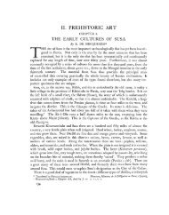
The Silk Road

Create successful ePaper yourself
Turn your PDF publications into a flip-book with our unique Google optimized e-Paper software.
proceed to northern Iran, across Central Asia<br />
(a region Iranian in speech and culture, and<br />
part of Khorasan, land of the sunrise), and<br />
eventually to China. <strong>The</strong> route was already<br />
ancient, antedating the coming of Islam by more<br />
than a millennium. <strong>The</strong> armies of Cyrus and<br />
Darius had marched that way, extending the<br />
rule of the Great King across Afghanistan as far<br />
as the Indus River. Alexander the Great followed<br />
in their footsteps. Goods from China had come<br />
by the Khorasan <strong>Road</strong> since the time of the Han,<br />
the Parthians and the Romans in the first<br />
centuries CE. So long as strong government was<br />
entrenched in Chang-an, and the rambunctious<br />
Turks were under control, the Khorasan <strong>Road</strong><br />
was the premier artery of long-distance trade<br />
and matches our common perception of the <strong>Silk</strong><br />
<strong>Road</strong>. And after the Arab conquest, pilgrims<br />
from the cities of Central Asia took the Khorasan<br />
<strong>Road</strong> on the annual Hajj to Mecca in Arabia.<br />
Going eastward, the Khorasan <strong>Road</strong> climbed<br />
onto the Iranian Plateau, crossing country<br />
inhabited chiefly by Kurds, and passed through<br />
cities that have endured triumph and disaster<br />
from antiquity to the present day. <strong>The</strong>n as now,<br />
Kermanshah was the chief city of Kurdistan,<br />
noted for its many trees, abundant fruit and<br />
the rock-cut alcoves of Tagh-e-Bostan with their<br />
spectacular Sasanian sculptures. Darius’<br />
triumphal inscription on the cliff of Bisitun was<br />
well known, though perhaps not fully<br />
understood: Ebn Hawkal read the panel<br />
depicting Darius with the tributary kings as the<br />
representation of a school-house, with the<br />
master and his boys. Hamadan, once capital of<br />
the Medes, was described as a fine and large<br />
city that had recovered from the destruction<br />
inflicted during the Arab conquest. <strong>The</strong> road<br />
then went by the important center of Rayy (see<br />
below), today a suburb of sprawling, smoggy<br />
Tehran. It then followed the southern foot of<br />
the Alborz Mountains to Nishapur, the chief city<br />
of Khorasan, described in detail by both Ebn<br />
Hawkal and Muqaddasi. Like other large towns<br />
of that time, Nishapur consisted of a fortress,<br />
the town proper and a suburb. All three were<br />
defended with walls, pierced by numerous gates<br />
that gave access to the extensive markets. No<br />
town in all of Khorasan was healthier or more<br />
populous than Nishapur, or more celebrated for<br />
its rich stores of merchandise and the wealth<br />
of its merchants.<br />
Continuing east, the road passed through Tus,<br />
a few miles north of today’s Mashad (which did<br />
not yet exist), an important regional center that<br />
was home to the poet Ferdowsi who flourished<br />
around 1000 CE. Here, on the fault-line between<br />
Iran and Turan, Ferdowsi composed the<br />
Shahname, Iran’s national epic. Nothing of Tus<br />
remains, except for the bleak ruins of its citadel.<br />
Turning northward, the Khorasan <strong>Road</strong> dropped<br />
down into the Kara Kum desert, making for the<br />
oasis city of Merv. Watered by an extensive<br />
network of canals, Merv is believed to have held<br />
a million inhabitants when the Mongols took it,<br />
and butchered every one. Of the splendors of<br />
Merv, only confused ruins and the mausoleum<br />
of a Seljuk sultan survive today. Beyond lay<br />
Bukhara, Samarkand and eventually, across the<br />
high Pamirs, half-legendary China.<br />
Well-traveled branches diverged from the<br />
Khorasan <strong>Road</strong> at many points, of which only<br />
the chief ones are shown on the map. From<br />
Hamadan one could journey southward onto the<br />
Mesopotamian plain, or southeast to the ancient<br />
city of Isfahan, several times the capital of Iran.<br />
One could also head north for Qazvin, there to<br />
pick up a western branch of the <strong>Silk</strong> <strong>Road</strong> for<br />
Tabriz, Dabil (not far from today’s Yerevan in<br />
Armenia) and eventually the port of Trebizond<br />
on the Black Sea. A further branch led northward<br />
to Ardebil, Tbilisi and the Caucasus. Nishapur<br />
was the point of departure for a track southward,<br />
between the parched basins shown on the map<br />
as the Great Salt Desert and the Great Sand<br />
Desert. And from Merv, routes led to Balkh,<br />
Herat, Kandahar and India.<br />
Little enough remains today of Rayy, the<br />
Greeks’ Rhages, which was a major hub of<br />
commerce and transport, and considered by<br />
some the finest city east of Baghdad. Rayy was<br />
the starting point for the major caravan route<br />
that skirted the western and southern side of<br />
the central deserts, on the way to the Persian<br />
Gulf or to India. Way stations still featured on<br />
maps include Qom, Kashan, Na’in, Yazd, Kerman<br />
and Bam, several of which we shall visit below.<br />
From this road, also, branches led forth. Several<br />
routes led to Isfahan and Shiraz; the latter<br />
began as an Arab foundation that grew into an<br />
important center, and today rules the South.<br />
Shiraz could also be reached from Baghdad, via<br />
Ahvaz. Several routes led northeast, across the<br />
central desert. Most important, here was the<br />
19