A SENSE OF PLACE Upper Primary 4..5

You also want an ePaper? Increase the reach of your titles
YUMPU automatically turns print PDFs into web optimized ePapers that Google loves.
2<br />
OUR ENVIRONMENT<br />
Map Literacy<br />
Map skills are a part of visual<br />
literacy — a set of skills to “read” and<br />
understand images. Can you read maps<br />
and use the information to solve a<br />
problem? I suspect the answer will be no<br />
or not confidently. In this chapter we<br />
explore the skills needed to read and<br />
interpret maps.<br />
Maps are resources that allow you to<br />
explore the immediate and distant<br />
environment. They have information that<br />
comes in the form of images and<br />
symbols. If you can interpret (decode) the<br />
images and understand them you can use<br />
them to make sense of your world. The<br />
secrets to understanding world time, the<br />
reasons for the seasons in different parts<br />
of the world and communicating the exact<br />
location of any place on earth are<br />
available when you are map literate.<br />
Additionally, we focus on your visual<br />
literacy and higher-order thinking skills —<br />
to take you into a deeper exploration of<br />
the planet you inhabit. How does this<br />
knowledge help you to read and<br />
understand the real world? Well, included<br />
are map conventions — the cardinal<br />
points, how to use a key, scale, map<br />
symbols, latitude and longitude and<br />
regions connected to seasons, and how<br />
to locate cities and countries. Where do<br />
you fit in? Let’s begin with the Cardinal<br />
Points.<br />
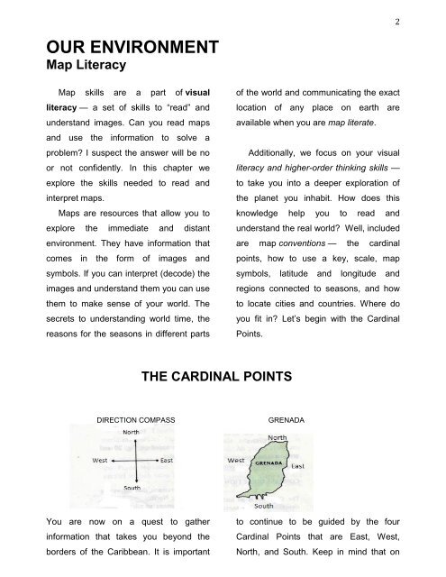
THE CARDINAL POINTS<br />
DIRECTION COMPASS<br />
GRENADA<br />
You are now on a quest to gather<br />
information that takes you beyond the<br />
borders of the Caribbean. It is important<br />
to continue to be guided by the four<br />
Cardinal Points that are East, West,<br />
North, and South. Keep in mind that on