lnm17402016
lnm17402016
lnm17402016
Create successful ePaper yourself
Turn your PDF publications into a flip-book with our unique Google optimized e-Paper software.
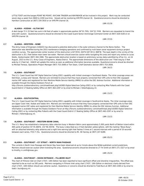
LITTLE TOOT and the barges POINT NO POINT, KVICHAK TRADER and WAYNEHOE will be involved in this project. Work may be conducted<br />
seven days a week from 0600 to 2200 local time. Vessels will be monitoring VHF/FM channel 16. Questions/concerns should be directed to<br />
Hamilton Construction at (907) 334-3910 or on VHF/FM channel 16.<br />
LNM: 01/16<br />
623<br />
637<br />
705<br />
ALASKA – KODIAK – ALITAK BAY<br />
A deck barge 72 X 25 feet has sunk in 84 feet of water in approximate position 56°53.79’N, 154°22.74’W. Mariners are requested to transit the<br />
area with caution. Questions/concerns should be directed to the Coast Guard Sector Anchorage Command Center at (907) 428-4100 or on<br />
VHF/FM channel 16.<br />
ALASKA – WESTERN – NOME<br />
The Army Corps of Engineers (USACE) has discovered a potential obstruction in the outer entrance channel to the Nome Harbor. The<br />
obstruction was identified during the 2015 maintenance dredging operations and confirmed by multi-beam sonar equipment during a project<br />
condition survey. The approximate center location of the obstruction is 64°29'41.344"N 165°26'11.968"W. The least depth in the vicinity of the<br />
obstruction is 20.1 feet below mean lower low water. Mariners should exercise caution while navigating this area and report any strikes to Lucas<br />
Stotts, Harbormaster (907) 304-1906. The approximate obstruction location is based on preliminary survey data submitted by eTrac Inc. on 24<br />
August, 2015 to the U.S. Army Corps of Engineers, Alaska District. The approximate dimensions of the obstruction are 7 feet long by 5 feet<br />
wide by 2.5 feet tall. USACE will update this notice as soon as additional information becomes available. Questions/concerns should be directed<br />
to Michael Teneza, Operations Project Manager (907) 753-2648 or Tom Sloan, Chief Geomatics Section (907) 753-2658.<br />
ALASKA – SOUTHEAST<br />
LNM: 37/15<br />
LNM: 34/15<br />
The U.S. Coast Guard has VHF Digital Selective Calling (DSC) capability with limited coverage in Southeast Alaska. The initial coverage areas are<br />
Ketchikan, Juneau and Yakutat. Mariners are reminded to ensure that they have properly connected their GPS units to their DSC equipped<br />
marine VHF radios and registered for their Maritime Mobile Service Identity (MMSI) to utilize the DSC distress function. Additional information is<br />
available through the Alaska Outdoors Forum at<br />
http://forums.outdoorsdirectory.com/showthread.php/142083-Digital-Selective-Calling-(DSC) or by contacting Mike Folkerts with the Coast<br />
Guard District 17 Boating Safety Office at (907) 463-2297 or by email to Michael.r.folkerts@uscg.mil.<br />
LNM: 15/15<br />
707<br />
726<br />
ALASKA – SOUTHCENTRAL<br />
The U.S. Coast Guard has VHF Digital Selective Calling (DSC) capability with limited coverage in Southcentral Alaska. The initial coverage areas<br />
are Upper Cook Inlet, Kodiak and Valdez Arm. Mariners are reminded to ensure that they have properly connected their GPS units to their DSC<br />
equipped marine VHF radios and registered for their Maritime Mobile Service Identity (MMSI) to utilize the DSC distress function. Additional<br />
information is available through the Alaska Outdoors Forum at http://forums.outdoorsdirectory.com/showthread.php/142083-Digital-Selective-<br />
Calling-(DSC) or by contacting Mike Folkerts with the Coast Guard District 17 Boating Safety Office at (907) 463-2297 or by email to<br />
Michael.r.folkerts@uscg.mil.<br />
ALASKA – SOUTHEAST – WESTERN BEHM CANAL<br />
LNM: 15/15<br />
The U.S. Navy has established a temporary data collection buoy in Western Behm canal approximately 5,000 yards North of Betton Island within<br />
400 yards of position 55°35.684’N, 131°46.503’W. The buoy is described as a 3 foot diameter yellow sphere, with the marking “Wave Buoy”,<br />
with an attached telemetry whip antenna and a night time warning light that flashes 5 times at 1 second intervals with a period of 20 seconds<br />
between each series, Fl(5) Y 25s. Questions/concerns should be directed to Mr. Bill Harney at (907) 247-6289.<br />
LNM: 05/15<br />
815<br />
816<br />
ALASKA – SOUTHEAST – ICY STRAIT – NORTH INIAN PASSAGE<br />
The currents in North Inian Passage and Glacier Bay have been observed at up to 3 knots above the NOAA published current predictions.<br />
Mariners should exercise caution when transiting the area. Questions/concerns should be directed to LT Tim Smith at (907) 271-3327 or by email<br />
to timothy.m.smith@noaa.gov.<br />
ALASKA – SOUTHEAST – DIXON ENTRANCE – FILLMORE INLET<br />
LNM: 25/14<br />
The chart of Fillmore Inlet on Chart 17437, 10th Edition has been reported to have significant offset and shoreline irregularities. The offset was<br />
reported to be as much as 500 yards. Mariners navigating in Fillmore Inlet using chart 17437, 10th Edition or electronic charts derived from<br />
chart 17437, 10th Edition should use extreme caution. Questions or concerns should be directed to Todd Buck at (907) 463-2269 or by email to<br />
todd.r.buck@uscg.mil.<br />
Page 6 of 11<br />
Coast Guard District<br />
17<br />
LNM: 40/16<br />
05 October 2016


