engineering
35_attachement_catalogue
35_attachement_catalogue

Create successful ePaper yourself
Turn your PDF publications into a flip-book with our unique Google optimized e-Paper software.
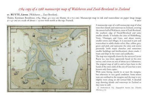
1784 copy of a 1568 manuscript map of Walcheren and Zuid-Beveland in Zeeland<br />
17. RU Y TE, Lieven. [Walcheren ... Zuyt Bevelant].<br />
Tholen, Korstiaen Bestebroer, 1784. Map: 42 × 52.5 cm (frame: 61 × 71.5 cm). Manuscript map in ink and watercolour on paper (map image<br />
37 × 47 cm) at a scale of about 1 : 55 000 with north at the top. Framed. € 1900<br />
A manuscript copy of a 1568 manuscript map of what<br />
were then islands and waterways in Zeeland, covering<br />
the eastern half of Walcheren, most of Zuid-Beveland,<br />
the southern edge of Noord-Beveland and some<br />
smaller islands. It includes the cities of Middelburg,<br />
Veere, Vlissingen and Goes, and about twenty<br />
smaller towns and villages. It is executed in pen and<br />
watercolour in subtle shades ochre, blue, yellow, grey,<br />
green and pink and represents the cities and towns<br />
pictorially (with major churches and sometimes<br />
smaller buildings and fortifications), shows roads, 7<br />
boats and ships in the water and sandbanks.<br />
The map was originally drawn by the surveyor Lieven<br />
Ruyte (ca. 1553–1601), apparently based on his own<br />
survey, and covers an area of about 19×27 kilometres.<br />
The original map of 1568 is said to have been in the<br />
hands of the town clerk of the city of Goes but is now<br />
known only from copies.<br />
With some foxing, mostly in or near the margins,<br />
but otherwise in very good condition. Some minor<br />
tears are confined to the margins and the map is very<br />
slightly worn along an old vertical fold. A detailed<br />
map showing islands and waterways in Zeeland as<br />
they were in 1568.<br />
Cf. Donkersloot-de Vrij, Topografische kaarten 692; Zelandia<br />
illustrata, p. 615.