- Page 1 and 2: ?*>1.l. ; ''.'.'
- Page 3 and 4: INTRODUCTION". The Year-book for 18
- Page 6 and 7: TABLE OF CONTENTS. STATISTICAL SUMM
- Page 8 and 9: 2 STATISTICAL YEAR BOOK. thence pas
- Page 10 and 11: 4 STATISTICAL YEAR BOOK. 1668. Talo
- Page 12 and 13: 6 STATISTICAL YEAR BOOK. 1708. The
- Page 14 and 15: 8 STATISTICAL YEAR BOOK. it came in
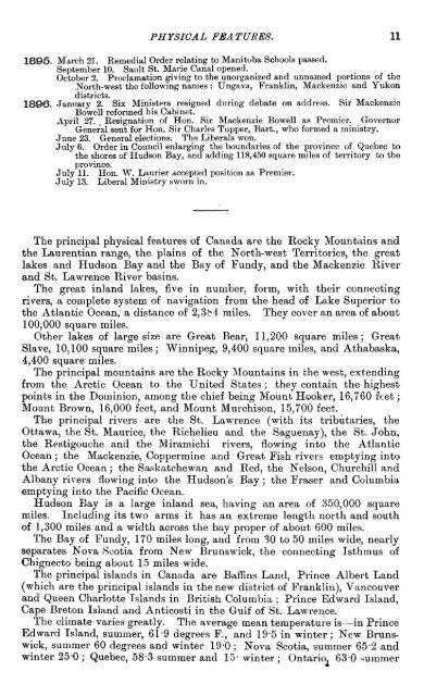
- Page 18 and 19: 12 STATISTICAL TEAR BOOK. and 19'8
- Page 20 and 21: 14 STATISTICAL YEAR BOOK. Other Cen
- Page 22 and 23: 16 STATISTICAL TEAR BOOK. QUALIFICA
- Page 24 and 25: 18 STATISTICAL YEAR-BOOK. (c.) Town
- Page 26 and 27: 20 STATISTICAL YEAR-BOOK. GOVERNORS
- Page 28 and 29: 22 STATISTICAL YEAR-BOOK. GOVERNORS
- Page 30 and 31: 24 STATISTICAL YEARBOOK. DOMINION P
- Page 32 and 33: 26 STATISTICAL YEAR-BOOK. LIST OF M
- Page 34 and 35: STATISTICAL YEAR-BOOK. LIST OF MEMB
- Page 36 and 37: 30 STATISTICAL YEAR-BOOK. LIST OF M
- Page 38 and 39: 32 STATISTICAL YEAR-BOOK. The Gener
- Page 40 and 41: 34 STATISTICAL YEAR-BOOK. PROVINCE
- Page 42 and 43: 36 STATISTICAL YEAR-BOOK. PROVINCE
- Page 44 and 45: 38 STATISTICAL YEAR-BOOK. PROVINCE
- Page 46 and 47: 40 STATISTICAL YEAR-BOOK. PROVINCE
- Page 48 and 49: 42 STATISTICAL YEAR-BOOK. In Januar
- Page 50 and 51: 44 STATISTICAL YEAR-BOOK. FOREIGN C
- Page 52 and 53: 46 STATISTICAL YEAR-BOOK. FOREIGN C
- Page 54 and 55: 48 STATISTICAL YEAR-BOOK. 184-9. Co
- Page 56 and 57: 50 S TA T1ST1GA L YEA R-BOOK. 188-5
- Page 58 and 59: 52 STATISTICAL YEAR-BOOK. There is
- Page 60 and 61: 54 S TA T1S TIG A L TEA R-BOOK. LET
- Page 62 and 63: 56 STATISTICAL YEAR-BOOK. The numbe
- Page 64 and 65: 58 STATISTICAL YEAR-BOOK. a permit
- Page 66 and 67:
60 STATISTICAL YEAR-BOOK. duties ar
- Page 68 and 69:
62 STATISTICAL YEAR-BOOK. Upper Ott
- Page 70 and 71:
64 STATISTICAL YEAR-BOOK. May 1st.
- Page 72 and 73:
66 STATISTICAL YEAR-BOOK. 7. That t
- Page 74 and 75:
68 STATISTICAL YEAR-BOOK. STATISTIC
- Page 76 and 77:
70 STATISTICAL YEAR-BOOK. . The oth
- Page 78 and 79:
72 STATISTICAL YEAR-BOOK. QUANTITIE
- Page 80 and 81:
74 STATISWICAL YEARBOOK. Value of t
- Page 82:
IUM|JMr-Ph--i©;0 aC^I OSCJTJi-OatO
- Page 85 and 86:
78 STATISTICAL YEAR-BOOK. HORSES, C
- Page 88 and 89:
80 STATISTICAL YEAR-BOOK. VALUES OF
- Page 90 and 91:
82 STATISTICAL YEAR-BOOK. STATEMENT
- Page 92 and 93:
84 STATISTICAL YEAR-BOOK. QUANTITIE
- Page 94 and 95:
86 STATISTICAL YEAR-BOOK. The follo
- Page 96 and 97:
STATISTICAL YEAR-BOOK. -CO 1C ON T)
- Page 98 and 99:
90 STATITISCAL YEAR-BOOK. The follo
- Page 100:
(MCOtr-ir50SI>.r--t-OlC ssaaasnisas
- Page 103 and 104:
94 STATISTICAL YEAR-BOOK. TOTAL NUM
- Page 105 and 106:
96 STATISTICAL TEAR-BOOK. The follo
- Page 107 and 108:
STATISTICAL YEAR-BOOK. to 00 00 Val
- Page 109 and 110:
STATISTICAL YEAR-BOOK. T3 a m 00 CD
- Page 111 and 112:
102 STATISTICAL YEARBOOK. The follo
- Page 113 and 114:
104 STATISTICAL YEAR-BOOK.. far as
- Page 115 and 116:
106 STATISTICAL YEAR-BOOK. The foll
- Page 117 and 118:
108 STATISTICAL TEAR-BOOK. IMPORTS
- Page 119 and 120:
110 STATISTICAL YEAR-BOOK. EXPORTS
- Page 121 and 122:
112 STATISTICAL YEAR-BOOK. IRON. Th
- Page 123 and 124:
114 STATISTICAL YEAR-BOOK. Followin
- Page 125 and 126:
116 STATISTICAL YEAR-BOOK. IMPORTS
- Page 127 and 128:
118 STATISTICAL YEAR-BOOK. Taking t
- Page 129 and 130:
120 STATISTICAL YEAR-BOOK. GOLD. Go
- Page 131 and 132:
122 S TA TIS TIC A L YEA R- BOOK. T
- Page 133 and 134:
124 STATISTICAL YEAR-BOOK. through
- Page 135 and 136:
126 STATISTICAL YEAR-BOOK. The foll
- Page 137:
QUANTITY AND VALUE OF SILVER PRODUC
- Page 140:
PH H CD(NXHCJ«iCOI>0(NmOOO lO Haia
- Page 143 and 144:
132 STATISTICAL YEAR-BOOK. A BRIEF
- Page 145 and 146:
134 STATISTICAL YEAR-BOOK. ONTARIO.
- Page 147 and 148:
136 STATISTICAL YEAE.BOOK. together
- Page 149 and 150:
138 STATISTICAL YEAR-BOOK. Tunnels
- Page 151 and 152:
140 STATISTICAL YEAR.BOOK. Lands co
- Page 153 and 154:
142 STATISTICAL YEAR-BOOK. o IS < o
- Page 155 and 156:
144 STATISTICAL YEAR-BOOK. Holland.
- Page 157 and 158:
146 STATISTICAL YEAR-BOOK. •u^dum
- Page 159 and 160:
148 STATISTICAL YEAR-BOOK. COtH coe
- Page 161:
CLASS B.—ARTICLES IN A CRUDE COND
- Page 164:
CLASS B.—ARTICLES IN A CRUDE COND
- Page 168:
CLASS C—ARTICLES WHOLLY OR PARTIA
- Page 172 and 173:
156 ST A T1S TICAL YEA E-BOOK. 83§
- Page 175:
CLASS D.—MANUFACTURED ARTICLES RE
- Page 179:
CLASS E .—ARTICLES OP VOLUNTARY U
- Page 182:
IMPORTS FOR HOME CONSUMPTION, DUTIA
- Page 185 and 186:
164 STATISTICAL YEAR-BOOK. A compar
- Page 187 and 188:
166 STATISTICAL YEAR-BOOK. SUMMARY
- Page 189 and 190:
168 STATISTICAL YEAR-BOOK. IMPORTS
- Page 191 and 192:
170 STATISTICAL YEAR-BOOK. The foll
- Page 193 and 194:
172 STATISTICAL YEAS-BOOK. 8 I OiMl
- Page 195 and 196:
174 STATISTICAL YEAR-BOOK. RELATIVE
- Page 197 and 198:
176 STATISTICAL YEAR-BOOK. RELATIVE
- Page 199 and 200:
178 STATISTICAL YEAR-BOOK. _. . . .
- Page 201 and 202:
180 STATISTICAL YEAR-BOOK. The foll
- Page 203 and 204:
182 STATISTICAL TEAR-BOOK. VALUE OF
- Page 205 and 206:
184 STATISTICAL YEAR-BOOK. EXPORTS
- Page 207 and 208:
185 STATISTICAL YEAR-BOOK. EXPORTS
- Page 209 and 210:
.188 ST A TISTIOA L YEA R-BOOK. and
- Page 211 and 212:
190 STATISTICAL YEAR-BOOK. The foll
- Page 213:
EXPORTS OF 1883 IN INDEX NUMBERS, T
- Page 216 and 217:
194 STATISTICAL YEAR-BOOK. From the
- Page 218 and 219:
196 STATISTICAL TEAR-BOOK. i-l i-l-
- Page 220 and 221:
198 STATISTICAL YEAR-BOOK, COCOOCM
- Page 222 and 223:
200 STATISTICAL THAU-BOOK. PERCENTA
- Page 224 and 225:
202 STATISTICAL YEAR-BOOK. The tota
- Page 226 and 227:
204 STATISTICAL YEAR-BOOK. bark, $1
- Page 228 and 229:
206 STATISTICAL YEAR-BOOK. FOREIGN
- Page 230 and 231:
203 STATISTICAL YEAR-BOOK. EXPORTS
- Page 232 and 233:
210 STATISTICAL YEAR-BOOK. clocks,
- Page 234 and 235:
212 STATISTICAL YEAR-BOOK. The prop
- Page 236 and 237:
214 STATISTICAL YEAR-BOOK. Taking s
- Page 238 and 239:
216 STATISTICAL YEAR-BOOK. DISCOUNT
- Page 240 and 241:
218 STATISTICAL YEAR-BOOK. Clearing
- Page 242 and 243:
220 STATISTICAL YEAR-BOOK. DUN & Co
- Page 244 and 245:
222 STATISTICAL YEAR-BOOK. becomes
- Page 246 and 247:
224 STATISTICAL YEAR-BOOK. GOVERNME
- Page 249 and 250:
226 STATISTICAL TEAR-BOOK. TRANSACT
- Page 251:
SUMMARY STATEMENT OF THE AFFAIRS OF
- Page 255 and 256:
230 STATISTICAL YEAB-BOOK. The foll
- Page 257 and 258:
232 STATISTICAL YEARBOOK. The propo
- Page 259:
The following is a comparative stat
- Page 263 and 264:
236 STATISTICAL YEAR-BOOK. PERCENTA
- Page 265:
STATEMENT OF THE GROSS AND NET INCO
- Page 268 and 269:
240 STATISTICAL YEAR-BOOK. PROPORTI
- Page 270 and 271:
242 STATISTICAL YEAR-BOOK. Out of t
- Page 272 and 273:
244 STATISTICAL YEAR-BOOK. The tota
- Page 274 and 275:
246 STATISTICAL YEAR-BOOK. PASSENGE
- Page 276 and 277:
248 STATISTICAL YEAR-BOOK. The chan
- Page 278 and 279:
250 STATISTICAL YEAR-BOOK. Since th
- Page 280 and 281:
252 STATISTICAL YEAR-BOOK. EARNINGS
- Page 283 and 284:
254 ST A T 1ST 10A L YEA E-BOOK. Th
- Page 285 and 286:
256 STATISTICAL YEAR-BOOK. The foll
- Page 288 and 289:
258 STATISTICAL YEAR-BOOK. o ii n p
- Page 291 and 292:
260 STATISTICAL YEAR-BOOK. The foll
- Page 293 and 294:
262 STATITISGAL YEAR-BOOK. REVENUE
- Page 295 and 296:
264 STATISTICAL YEARBOOK. The follo
- Page 297 and 298:
266 S TA TIS TIC A L YEA R- BOOK. C
- Page 299 and 300:
268 STATISTICAL TEAR-BOOK. The foll
- Page 301 and 302:
270 STATISTICAL YEAR-BOOK. M a mm F
- Page 303 and 304:
272 STATISTICAL YEAR-BOOK. SUMMARY
- Page 305 and 306:
274 STATISTICAL YEAR-BOOK. QUANTITI
- Page 307 and 308:
276 STATISTICAL TBAS-SOOK. CANADIAN
- Page 309 and 310:
278 STATISTICAL YEAR-BOOK. The tota
- Page 311 and 312:
* • 280 STATISTICAL YEAR-BOOK. Th
- Page 313 and 314:
282 STATISTICAL YEAR-BOOK. REVENUE
- Page 315 and 316:
284 STATISTICAL YMAR-BOOK. The foll
- Page 317 and 318:
286 STATISTICAL 7EAR-BOOK. TOTAL TO
- Page 319:
o «H ft! e & "? . .S •'• the p
- Page 322:
ililill 1111 ggg§ 3^ T* &* &&>&> j
- Page 326 and 327:
292 STATISTICAL YEAR-BOOK. The foll
- Page 328:
TONNAGE CARRYING d. ^ H £ o Pi i a
- Page 331 and 332:
296 STATISTICAL TBAR-BOOK. VESSELS
- Page 333 and 334:
298 ST A Tin TWA L YEA R-BOOK. The
- Page 335 and 336:
300 STATISTICAL YEAR-BOOK. The foll
- Page 337 and 338:
302 STATISTICAL YEAR-BOOK. SHIPPING
- Page 339 and 340:
304 STATISTICAL YEAR-BOOK. POST OFF
- Page 341 and 342:
306 STATISTICAL YEAR-BOOK. ESTIMATE
- Page 343 and 344:
308 STATISTICAL YEAR-BOOK. The numb
- Page 345 and 346:
310 STATISTICAL YEAR-BOOK. OPERATIO
- Page 347 and 348:
312 STATISTICAL YEAR-BOOK. NUMBER O
- Page 349 and 350:
314 STATISTICAL YEAR-HOOK. CUSTOMS
- Page 351 and 352:
316 STATISTIPAL YEAR-BOOK. MISCELLA
- Page 353 and 354:
318 STATISTICAL TEAR-BOOK. PAYMENT
- Page 355 and 356:
320 STATISTICAL YEARBOOK. •H a O
- Page 357 and 358:
STATISTICAL YEAR-BOOK. Q0l0OHttiffi
- Page 359 and 360:
324 STATISTICAL YEARBOOK. ~5 T3 -0
- Page 361 and 362:
326 STATISTICAL TEAS-BOOK. o P K P3
- Page 363 and 364:
3SJ8 STATISTICAL YEARBOOK. PROPORTI
- Page 365 and 366:
330 STATISTICAL YEARBOOK. ۩ SlH
- Page 367 and 368:
332 ST A TIS TWA L. YEA B.-BO OK. R
- Page 369 and 370:
334 STATISTICAL YEAR-BOOK. TAXATION
- Page 371 and 372:
336 STATISTICAL YEAR-BOOK. o s 8 »
- Page 373 and 374:
338 STATISTICAL YEAR-BOOK. S". OX-t
- Page 375 and 376:
340 STATISTICAL YEAR-BOOK. TAXATION
- Page 377 and 378:
342 STATISTICAL YEAR-BOOK. The foll
- Page 379:
HPPIJI-iHHHPI-'l-'l-'l-'HPHHPHwpHHP
- Page 382 and 383:
346 STATISTICAL YEAR-BOOK. The foll
- Page 384 and 385:
348 6TA TISTICAL YEAR-BOOK. PUBLIC
- Page 386 and 387:
350 STATISTICAL TEAR-BOOK. Pensions
- Page 388 and 389:
352 STATISTICAL YEAR-BOOK. PROVINCE
- Page 390 and 391:
354 STATISTICAL YEAR-BOOK. PRICES.
- Page 392 and 393:
356 ST A TIST10A L YEA R-BOOK. Amou
- Page 394:
"co " O " M W h - ^ "o -£-II 3 CO
- Page 397 and 398:
360 STATISTICAL YEAR-BOOK. CANADIAN
- Page 399 and 400:
362 STATISTICAL YEAR-BOOK. FIRE INS
- Page 401 and 402:
STATISTICAL TEAR-BOOK. LIFE INSURAN
- Page 403:
1891. Death Rate. 10-178 9 345 20 1
- Page 406 and 407:
368 STATISTICAL YEAR-BOOK. CANADIAN
- Page 408:
The following table has been prepar
- Page 412 and 413:
372 STATISTICAL YEAR-BOOK. In the a
- Page 414 and 415:
374 STATISTICAL TEAR-BOOK. ©b-NtOW
- Page 416 and 417:
376 STATISTICAL YEAR-BOOK. TELEGRAP
- Page 418 and 419:
378 STATISTICAL YEARBOOK. TELEGRAPH
- Page 420 and 421:
380 STATISTICAL YEAR-BOOK. FINANCIA
- Page 422 and 423:
382 STATISTICAL YEAR-BOOK. England
- Page 424:
KOMAN CATHOLIC SEPARATE SCHOOLS, ON
- Page 427 and 428:
386 STATISTICAL YEAR-BOOK. In the H
- Page 429 and 430:
388 STATISTICAL YEAR-BOOK. a H SSII
- Page 431 and 432:
390 STATISTICAL YEAR-BOOK. QUEBEC.
- Page 433 and 434:
392" STATISTICAL YEAR-BOOK. The fol
- Page 435 and 436:
394 STATISTICAL YEAR-BOOK. NOVA SCO
- Page 437 and 438:
396 STATISTICAL YEAR-BOOK. TOTAL RE
- Page 439 and 440:
398 STATISTICAL YEAR-BOOK. NEW BRUN
- Page 441 and 442:
400 STATISTICAL YEAR-BOOK. Collegia
- Page 443 and 444:
402 STATISTICAL YEAR-BOOK. EDUCATIO
- Page 445 and 446:
404 STATISTICAL YMAE-BOOK. EDUCATIO
- Page 447 and 448:
406 STATISTICAL YEAR-BOOK. In the Y
- Page 449 and 450:
408 STATISTICAL YEAR-BOOK. THE HIGH
- Page 451 and 452:
410 STATISTICAL YEAR-BOOK. CANADA.
- Page 453 and 454:
412 STATISTICAL YEAR-BOOK. These co
- Page 455 and 456:
414 STATISTICAL YEARBOOK. RECEIPTS
- Page 457 and 458:
418 STATISTICAL TEAR-BOOK. STATEMEN
- Page 459 and 460:
418 STATISTICAL YEAR-BOOK. STATEMEN
- Page 461 and 462:
420 STATISTICAL YEAR-BOOK. SII8HISI
- Page 463 and 464:
422 STATISTICAL YEAR-BOOK. The foll
- Page 465 and 466:
424 STATISTICAL YEAR-BOOK. The quan
- Page 467 and 468:
426 STATISTICAL YEAR-BOOK. PATENT O
- Page 469 and 470:
428 STATISTICAL YEAR-BOOK. BIRTHS,
- Page 471 and 472:
430 STATISTICAL YEAR-BOOK. The foll
- Page 473 and 474:
432 STATISTICAL YEAR-BOOK. The foll
- Page 475:
OFFENCES FOR WHICH PERSONS WERE COM
- Page 478 and 479:
436 STATISTICAL YEAR-BOOK. The foll
- Page 480 and 481:
438 STATISTICAL YEAR-BOOK. The foll
- Page 482 and 483:
440 STATISTICAL YEAR-BOOK. TOTAL NU
- Page 484 and 485:
442 STATIS110AL TEAR-BOOK. g§gsss
- Page 487 and 488:
444 STATISTICAL YEAR-BOOK. The foll
- Page 490 and 491:
446 S TA TISTIGA L YEAR-BOOK. The f
- Page 492 and 493:
418 STATISTICAL TEAR-BOOK. OFFENCES
- Page 494 and 495:
450 STATISTICAL YEAR-BOOK. The foll
- Page 496 and 497:
452 STATISTICAL YEAR-BOOK. AGES OF
- Page 498 and 499:
454 STATISTICAL TEAR-BOOK. The foll
- Page 500 and 501:
456 STATISTICAL YEAR-BOOK. THE HOUS
- Page 502 and 503:
458 STATISTICAL YEAR-BOOK. SPEAKER
- Page 504 and 505:
460 STATISTICAL YEAR-BOOK. PROVINCE
- Page 506 and 507:
462 STATISTICAL YEAR-BOOK. PROVINCE
- Page 508 and 509:
464 STATISTICAL YEAR-BOOK. NORTH-WE
- Page 510 and 511:
466 STATISTICAL YEAR-BOOK. PAGE. Br
- Page 512 and 513:
468 STATISTICAL YEARBOOK. PAGE. Dep
- Page 514 and 515:
470 STATISTICAL YEAR-BOOK. PAGB. Go
- Page 516 and 517:
472 STATISTICAL YEAR-BOOK. , • .
- Page 518 and 519:
474 STATISTICAL TMAR-BOOK. Petroleu
- Page 520 and 521:
476 STATISTICAL YEAR-BOOK. PAGE. ;