Garmin Earthmate® PN-60 - Owner's Manual
Garmin Earthmate® PN-60 - Owner's Manual
Garmin Earthmate® PN-60 - Owner's Manual

Create successful ePaper yourself
Turn your PDF publications into a flip-book with our unique Google optimized e-Paper software.
DELORME<br />
®<br />
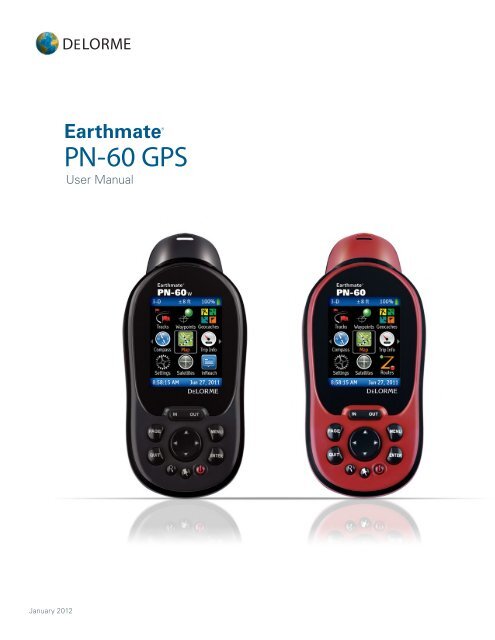
Earthmate<br />
<strong>PN</strong>-<strong>60</strong> GPS<br />
User <strong>Manual</strong><br />
January 2012
WARNING: Messaging, tracking and SOS functions require an active Iridium satellite<br />
subscription. Always test your device before you go.<br />
This manual is provided as a convenience.<br />
GARMIN IS NOT RESPONSIBLE FOR THE ACCURACY OF THIS MANUAL AND<br />
DISCLAIMS ANY LIABILITY ARISING FROM THE RELIANCE THEREON.
Contents<br />
Getting Started ............................................................................................................................... 3<br />
Home Page ..................................................................................................................................... 9<br />
Map Page ..................................................................................................................................... 10<br />
Satellites Page .............................................................................................................................. 18<br />
Compass Page .............................................................................................................................. 20<br />
Trip Info Page ................................................................................................................................ 22<br />
Find Page ...................................................................................................................................... 24<br />
Waypoints Page ............................................................................................................................ 29<br />
Geocaches Page ........................................................................................................................... 33<br />
Routes Page ................................................................................................................................. 38<br />
Tracks Page ................................................................................................................................... 42<br />
Profile Page ................................................................................................................................... 46<br />
Sun/Moon Page ............................................................................................................................ 48<br />
Tides Page .................................................................................................................................... 50<br />
Hunt/Fish Page ............................................................................................................................. 51<br />
Activities Page .............................................................................................................................. 52<br />
Settings Page ................................................................................................................................ 53<br />
File Management .......................................................................................................................... 58<br />
Compass and Altimeter Calibration ............................................................................................... 59<br />
Info Fields ..................................................................................................................................... 61<br />
Specifications and Warranty ......................................................................................................... 64<br />
Service Plan and Contact Info ....................................................................................................... 66<br />
Index ............................................................................................................................................. 67<br />
Updated 01/12/2012
Getting Started<br />
This manual is for use with DeLorme Earthmate ® <strong>PN</strong>-<strong>60</strong>/<strong>PN</strong>-<strong>60</strong>w GPS devices. References to “<strong>PN</strong>-<strong>60</strong>” include both<br />
devices unless otherwise indicated.<br />
The Earthmate <strong>PN</strong>-<strong>60</strong>/<strong>60</strong>w is a complete out-of-the-box handheld GPS solution for all your outdoor activities.<br />
••<br />
Navigate worry-free with included topographic maps of the U.S. and Canada.<br />
••<br />
Add high-resolution aerial imagery for a unique GPS experience.<br />
••<br />
Enjoy next-generation GPS features and performance.<br />
What’s in the box<br />
••<br />
Earthmate <strong>PN</strong>-<strong>60</strong> or <strong>PN</strong>-<strong>60</strong>w GPS<br />
••<br />
Quick Start Guide<br />
••<br />
DeLorme Topo North America ® DVD<br />
OR<br />
DeLorme XMap ® DVD, XMap User <strong>Manual</strong>, and XMap North America Topographic DVD<br />
••<br />
USB cable<br />
••<br />
2 lithium batteries<br />
••<br />
Lanyard<br />
Where to get more help<br />
You can find detailed help and information in several ways.<br />
User <strong>Manual</strong>s<br />
The latest version of this comprehensive user manual is available as a PDF download. manuals.delorme.com. The<br />
inReach User <strong>Manual</strong> and SPOT Satellite Communicator User <strong>Manual</strong> are also available for download.<br />
Technical Support<br />
A searchable knowledge base provides detailed technical information about current and past DeLorme products.<br />
support.delorme.com<br />
Community Forums<br />
An open interactive community of DeLorme product users shares its experiences. DeLorme experts monitor the<br />
boards to participate and answer questions. forum.delorme.com<br />
Mapping applications<br />
Our desktop and web mapping applications include comprehensive help files.<br />
Batteries and SD Card<br />
••<br />
Use two AA batteries (Lithium is recommended; you can also use NiMH or alkaline) or a DeLorme rechargeable<br />
lithium-ion (li-ion) battery.<br />
••<br />
When the <strong>PN</strong>-<strong>60</strong> is using battery power, the battery indicator on the Home Page displays the percentage of<br />
battery life remaining.<br />
••<br />
Remove the batteries when storing the <strong>PN</strong>-<strong>60</strong> for a month or longer.<br />
• • A slot for an SD card (not included) is underneath the batteries inside the battery compartment. SD/SDHC/MMC<br />
cards up to 32GB are supported.<br />
Earthmate <strong>PN</strong>-<strong>60</strong> User <strong>Manual</strong> | Getting Started<br />
3
USB cable connector<br />
Battery polarity symbols<br />
SD card slot<br />
SD card latch<br />
To<br />
Install batteries and SD card<br />
Check battery type<br />
Do this<br />
1. Unscrew the D-rings on the back of the device until you can remove the battery<br />
cover.<br />
2. Optional. To insert an SD card, gently press down the SD card latch, insert the<br />
card in the slot, and press down the slot to close the latch. Note Do not lift the<br />
SD card latch as this could cause damage.<br />
3. Insert the batteries according to the polarity symbols inside the battery<br />
compartment.<br />
4. Replace the back cover and screw in the D-rings.<br />
Go to Settings > System > Battery Type and make sure the correct battery type is<br />
selected; this ensures that the battery indicator displays the correct amount of battery<br />
life remaining.<br />
View battery indicator The battery indicator is on the Home Page (see page 9).<br />
Charge DeLorme Li-ion<br />
battery in the <strong>PN</strong>-<strong>60</strong><br />
Install the battery in the device.<br />
To leave the device powered on while charging, power it on and connect the USB<br />
cable to the computer. On the Home Page, the battery indicator displays a plug.<br />
OR<br />
To put the device in charging mode, power it off and connect the USB cable to the<br />
computer. The light indicator below the bottom left corner of the screen flashes red.<br />
When the device is fully charged, the light is green.<br />
Improve battery life<br />
••<br />
Automatically turn off the backlight after 15 seconds; go to Settings > Display > Backlight Timer > 15 sec.<br />
••<br />
Use the power saving option; go to Settings > System > GPS Setting > Power Saving.<br />
••<br />
Turn off the GPS receiver when inside. Go to Settings > System > GPS Setting > Off.<br />
OR<br />
From the Satellites Page, go to MENU > Turn Off GPS.<br />
••<br />
Use batteries with higher milliamp-hour (mAh) ratings.<br />
4 Getting Started | Earthmate <strong>PN</strong>-<strong>60</strong> User <strong>Manual</strong>
Power<br />
The Power button<br />
is at the bottom right corner of the button area.<br />
••<br />
To turn on the <strong>PN</strong>-<strong>60</strong>, press and hold Power until you see the Welcome screen.<br />
••<br />
To turn off the <strong>PN</strong>-<strong>60</strong>, press Power and hold for 1.5 seconds until the “Shutting down the device message”<br />
displays. Then, release the button.<br />
Demo Mode<br />
The first time you turn on the <strong>PN</strong>-<strong>60</strong>, it opens in Demo Mode.<br />
••<br />
To view the demo, follow the on-screen instructions.<br />
••<br />
To exit the demo, press QUIT.<br />
••<br />
To turn off Demo Mode—from the first screen, press ENTER to clear the Show at Startup check box.<br />
••<br />
To restore Demo Mode, go to Settings > System > GPS Setting > Demo Mode.<br />
Buttons<br />
Power<br />
Use the Power button to turn the <strong>PN</strong>-<strong>60</strong> on and off, lock the buttons, or to change the backlight settings.<br />
••<br />
To turn on the device, press and hold the Power button until the Welcome screen displays.<br />
Note The first time you use the device it will be in Demo Mode.<br />
••<br />
To turn off the device, press the Power button until the “Shutting down the device” message displays.<br />
••<br />
To open the power options screen, quickly press and release the Power button. The following options are available:<br />
»»<br />
To change the backlight intensity, use the arrow keypad to adjust the backlight slider.<br />
••<br />
To lock the buttons, select Yes when you see the “Lock the buttons?” message.<br />
Tips<br />
»»<br />
To unlock the buttons, press Power. Then, select Yes when you see the “Unlock the Buttons?" message.<br />
••<br />
Reduce the backlight intensity and decrease the timer to significantly improve battery life.<br />
••<br />
The TFT screen is readable in direct sunlight or slanting light conditions.<br />
••<br />
For more information about backlight intensity and the back light timer, see Settings > Display (page 54).<br />
In/Out<br />
Use the IN/OUT button to zoom the map or a track profile in or out or scroll through a list.<br />
••<br />
Press IN once to zoom the map or a track profile in one level and show more detail.<br />
••<br />
Press and hold IN to zoom the map in all the way.<br />
••<br />
Press OUT once to zoom the map or a track profile out one level and show less detail.<br />
••<br />
Press and hold OUT to zoom the map out all the way.<br />
••<br />
Press IN or OUT to move forward or backward one page at a time when viewing lists.<br />
Earthmate <strong>PN</strong>-<strong>60</strong> User <strong>Manual</strong> | Getting Started<br />
5
Page<br />
Press the PAGE button to move forward through the pages in the page order sequence. To add, remove, or reorder<br />
pages, go to Settings > Page Order. The default page sequence is determined by the current activity setting.<br />
Menu<br />
Press the MENU button to access functions for the page or screen you are using.<br />
••<br />
From any page, press the MENU button twice to go to the Home Page.<br />
••<br />
From any main menu, press the MENU button to go to the Home Page.<br />
••<br />
The menu lists actions specific to the active page—select the item and press ENTER.<br />
Find<br />
The Find button is labeled with a magnifying glass. Press it to open the Find Page, where you can search the map for a<br />
point of interest, address, coordinates, and more. You can also search for waypoints and geocaches in an open waypoint<br />
or geocache file. For more information, see Find Page on page xx.<br />
Mark<br />
The Mark button is labeled with a pushpin. Use it to mark a waypoint at your current GPS location or, when panning, at<br />
the cursor location. Once you mark a waypoint, use its details page to manage it, view it on the map, or create a route<br />
to it. For more information, see Waypoints Page on page xx.<br />
Arrow Keypad<br />
Use the arrow keypad to move around pages and screens.<br />
••<br />
Press once to move the map cursor left, right, up, or down in increments.<br />
••<br />
Press and hold to pan the map in that direction.<br />
••<br />
Highlight options in menus or lists. Press down to move to the next entry, press up from the first entry to go to the<br />
last entry, or press down from the last entry to go to the first entry.<br />
••<br />
Highlight fields and highlight characters on the keyboard screen.<br />
••<br />
Press and hold to quickly scroll through a menu or list.<br />
••<br />
On the Map Page, press any arrow once to turn on the backlight without changing the map view.<br />
Enter<br />
Press the ENTER button to:<br />
••<br />
Complete the selection of a menu option, entry, field, or screen button.<br />
••<br />
Get detailed information about a point on the map, if available.<br />
Quit<br />
The function of the QUIT button depends on the status of the <strong>PN</strong>-<strong>60</strong>; some of the things you can do are:<br />
••<br />
Exit a page or screen.<br />
••<br />
Cancel actions (for example, panning).<br />
••<br />
Close the keyboard and cancel changes.<br />
6 Getting Started | Earthmate <strong>PN</strong>-<strong>60</strong> User <strong>Manual</strong>
••<br />
Delete individual points when measuring distance.<br />
••<br />
Move backwards through the page order sequence.<br />
On-screen Keyboard<br />
The on-screen keyboard is available when you need to enter text, such as when editing a waypoint label, adding text to<br />
a comment field, or entering search parameters.<br />
Use the arrow keypad to highlight the letter, number, symbol, or punctuation you want to use, and then press ENTER<br />
after each selection. When you are finished using the keyboard, highlight OK and press ENTER.<br />
For existing text, enter a letter to replace the highlighted content. To keep the existing text but move the cursor to the<br />
beginning/end of the text, select to move the cursor to the beginning or to move the cursor to the end of the<br />
text.<br />
Special Keys<br />
Move the cursor one space to the left without deleting a letter or number.<br />
Move the cursor one space to the right without deleting a letter or number.<br />
Change the case of the next letter (the active case is shown in the keyboard).<br />
To use all caps, highlight and then press ENTER twice. Also changes numbers to additional symbols.<br />
Move the cursor one space to the left, deleting the character that was there.<br />
Insert a line break and move the cursor to the next line.<br />
Clear the content of the field being edited.<br />
Accept the changes made to the text field and close the keyboard.<br />
Keyboard Shortcuts<br />
These button presses are keyboard shortcuts.<br />
••<br />
IN–Delete the last character.<br />
••<br />
OUT–Add a space.<br />
••<br />
Find–Shift (for upper case and to show extra symbols).<br />
••<br />
Mark–Highlight OK.<br />
••<br />
QUIT–Exit the keyboard.<br />
• • MENU–Move the cursor’s focus from the keyboard to the text box for faster editing.<br />
Press again to return to the keyboard.<br />
Earthmate <strong>PN</strong>-<strong>60</strong> User <strong>Manual</strong> | Getting Started<br />
7
Info Fields<br />
The Map, Compass, Trip Info, and Profile Pages include fields of information that you can customize to suit your needs.<br />
You can even change which info fields display depending on your activity. For each activity, the info field types change<br />
for navigating or tracking (<strong>reg</strong>ular GPS use).<br />
Tip To change the info fields for an activity navigation/tracking mode, put the device in that mode before you start making<br />
changes. It is easy to go back to the default settings at any time.<br />
For more information about what info fields contain, see Info Fields on page 61. For more information about<br />
Activities, see Activities Page on page 52.<br />
To<br />
Hide or show info fields<br />
Arrange info fields<br />
Change text size<br />
Change info fields<br />
Restore info fields<br />
Do this<br />
On the Map Page, you can hide info fields for a full-screen view of the map or show<br />
them to get information.<br />
Go to MENU > Info Fields and select Hide Info Fields or Show Info Fields.<br />
On the Map Page and Compass Page, you can change how info fields look on the<br />
screen.<br />
Go to MENU > Info Fields > Arrange Info Fields and select an option.<br />
On the Trip Info Page, you can change the size of the text that displays, which also<br />
changes the number of info fields. When the device is set to the small text option, it<br />
displays eight info fields (2 wide, 6 narrow)—when it is set to the large text option, it<br />
displays three wide info fields.<br />
Press MENU. The available text size option is preceded by “Switch to.” Highlight the<br />
option and press ENTER.<br />
On the Map, Compass, Profile, and Trip Info pages, you can customize which info<br />
fields display.<br />
1. From the page, go to MENU > Info Fields > Change Info Fields.<br />
2. Select the info field you want to change and press ENTER. A list of available info<br />
fields opens.<br />
3. Select the new info field and press ENTER.<br />
4. When you finish editing fields, press QUIT. The changes are saved until you<br />
change them again or restore them to the default settings.<br />
On the Map, Compass, Profile and Trip Info Pages, you can restore the default info<br />
fields for your current activity.<br />
From the page, go to MENU > Info Fields > Restore Info Fields.<br />
Navigating or Tracking<br />
Tracking is the normal state of the device when it has a GPS fi x. You can turn off track recording, but the device is still<br />
in tracking mode. When you follow a route on the device, you are navigating.<br />
8 Getting Started | Earthmate <strong>PN</strong>-<strong>60</strong> User <strong>Manual</strong>
Home Page<br />
The Home Page uses icons to give you a quick and easy way to locate the page on the device you want to view.<br />
Use the arrow keypad to select an icon and then press ENTER to open that page. The Home Page also displays the GPS<br />
status (top left) and accuracy (top center), and the battery indicator (top right). The time and date are displayed at the<br />
bottom of the page.<br />
••<br />
To quickly get to the Home Page, from any page on the <strong>PN</strong>-<strong>60</strong>, press MENU twice.<br />
••<br />
To switch pages, press the right or left arrow until the page view changes.<br />
To change the Home Page icon order<br />
You can change the order of the Home Page icons for each activity. Go to MENU > Customize Home Page and press<br />
ENTER. Select an icon and press ENTER. The icon frame turns into arrows. Use the arrow keypad to move the icon, and<br />
then press ENTER.<br />
Tracks Settings Sun/Moon<br />
Waypoints Satellites Routes<br />
Geocaches<br />
inReach<br />
<strong>PN</strong>-<strong>60</strong>w only<br />
Profile<br />
Compass<br />
SPOT<br />
<strong>PN</strong>-<strong>60</strong>w only<br />
Activities<br />
Map<br />
Tides<br />
Trip Info<br />
Hunt/Fish<br />
Earthmate <strong>PN</strong>-<strong>60</strong> User <strong>Manual</strong> | Home Page<br />
9
Map Page<br />
The Map Page centers the map on your current location when the <strong>PN</strong>-<strong>60</strong> has a 2-D or 3-D fix. When it does not have a<br />
GPS fix, the map displays your last GPS position, or, if panning the map, the map cursor position. For more information,<br />
see GPS and WAAS Status on page 18.<br />
North Arrow (orientation)<br />
GPS Arrow<br />
Scale<br />
Info Fields<br />
GPS Arrow<br />
The GPS arrow displays on the map when GPS is turned on. The color of the GPS arrow depends on your GPS signal<br />
and the arrow points in the direction of the last known heading.<br />
••<br />
Flashing Red–The device cannot obtain a GPS signal and is not tracking satellites.<br />
••<br />
Blue–The device is in Track Playback mode or Simulate Navigation mode.<br />
••<br />
Yellow–The device has a 2-D fix. If a 3-D fix has not been obtained, predicted ephemeris is available.<br />
••<br />
Green–The device has a 3-D fix.<br />
Tracking<br />
When tracking satellites, a track line—also known as a breadcrumb trail—follows the GPS arrow as you move.<br />
If you have turned off track recording, the track does not appear. For more information, see Tracks Page on page 42.<br />
Scale and Orientation<br />
For information about:<br />
••<br />
Setting the scale, see Scale on page 15.<br />
••<br />
Map orientation, see Orientation on page 14.<br />
Panning the Map<br />
There are two ways to pan the map. When you pan the map, the map cursor—a white arrow—shows your location.<br />
••<br />
Automatic panning–When GPS tracking or navigating, the map automatically pans in the direction of travel. The<br />
map does not automatically pan when the map cursor is visible. Press QUIT to remove the map cursor and return<br />
to automatic panning.<br />
10 Map Page | Earthmate <strong>PN</strong>-<strong>60</strong> User <strong>Manual</strong>
••<br />
<strong>Manual</strong> panning–To manually pan the map, use the arrow keypad to move the cursor in the direction you want to<br />
view.<br />
»»<br />
Use single presses to move the cursor in increments.<br />
»»<br />
Press and hold to quickly pan to a new location.<br />
»»<br />
Hold the cursor at the edge of the screen to keep panning in that direction; the map will move to the new<br />
location.<br />
»»<br />
Press QUIT to center the map on your current location.<br />
As you pan, a text field at the top of the map displays information about the cursor location. When you stop the cursor<br />
over an object, the field in the bottom left corner displays the object name.<br />
Getting Location Information<br />
For information about objects at your current GPS location, press ENTER.<br />
OR<br />
Pan the map to a new location. When you stop the cursor over an object, the object’s name is displayed in the bottom<br />
left corner of the map. Press ENTER.<br />
••<br />
For single objects, the object details page displays. From this page, you can mark a waypoint, view the object on<br />
the map, or route to the object.<br />
••<br />
For multiple objects, the Multiple Objects screen displays a list of the objects at that location; user-created objects<br />
(such as waypoints) appear at the top of the list. Select an object and then press ENTER to view its details page.<br />
Info Fields<br />
The Map Page includes fields of information that you can customize to suit your needs. You can even change which<br />
info fields display depending on your activity. For each activity, the info field types change for navigating or The Map<br />
Page includes fields of information that you can customize to suit your needs. You can even change which info fields<br />
display depending on your activity. For each activity, the info field types change for navigating or tracking (<strong>reg</strong>ular GPS<br />
use). To access the Info Fields options, go to MENU > Info Fields. For more information, see Info Fields on page<br />
61 and Activities Page on page 52.<br />
Measure Distance<br />
Use the measurement tool to measure the distance of a line or the perimeter and area of a polygon on the map.<br />
To measure distance<br />
From the Map Page, go to MENU > Measure Distance. Use the arrow keypad to move the cursor to the area on the<br />
map where you want to place the first point of the line or polygon and press ENTER. Repeat for each point.<br />
••<br />
To undo a point, press QUIT.<br />
• • To make a polygon, you must close the shape. Place the last point on top of the first point by hovering the cursor<br />
over the start location and pressing ENTER to snap the point and close the polygon.<br />
Earthmate <strong>PN</strong>-<strong>60</strong> User <strong>Manual</strong> | Map Page<br />
11
While you are measuring distance, the pan location information that displays in the top right corner of the screen<br />
changes to display the heading from the last measurement node to your current GPS location, the leg distance, and the<br />
total distance from the last measurement node to the first measurement node. Once you close a polygon, it displays<br />
the area.<br />
Turn Imagery On/Off<br />
When you have added map packages that include imagery to your <strong>PN</strong>-<strong>60</strong>, you can quickly turn the imagery off or on.<br />
From the Map Page, go to MENU > Turn Imagery On or Turn Imagery Off.<br />
Map Setup<br />
Use the Map Setup page to customize the map. You can change the order of data layers; show or hide maps and imagery;<br />
choose map orientation and scale; and determine how information displays on the map.<br />
From the Map Page, go to MENU > Map Setup.<br />
Data Layering<br />
The base map that is pre-loaded on the <strong>PN</strong>-<strong>60</strong> shows high-level world coverage, as well as more detailed coverage for<br />
North America. You can add maps, data, imagery, draw files, and more to your device to supplement the base map.<br />
When you add different types of maps to the same area, you can customize the order in which the layers appear.<br />
For more information about the types of data you can add to your <strong>PN</strong>-<strong>60</strong>, see Detailed Map Data on page 14.<br />
To manage individual map packages that you have added to your device, see Data Management on page 13.<br />
Only the data types you have on your device show in the Data Layering list.<br />
12 Map Page | Earthmate <strong>PN</strong>-<strong>60</strong> User <strong>Manual</strong>
The default order for layering data is:<br />
••<br />
GIS layers by name (XMap only)<br />
••<br />
Draw Layers<br />
••<br />
Public Lands<br />
••<br />
User Raster Data (XMap only)<br />
••<br />
Custom Raster Data (XMap only)<br />
••<br />
ImageReg (XMap only)<br />
••<br />
DigitalGlobe ® 30cm (DG 30cm)<br />
••<br />
High-resolution City Imagery (Hi-Res Cities)<br />
••<br />
DigitalGlobe <strong>60</strong>cm (DG <strong>60</strong>cm)<br />
••<br />
DigitalGlobe 1m (DG 1m)<br />
••<br />
Color Aerial Imagery (Color DOQQ)<br />
••<br />
Aerial Imagery (DOQQ)<br />
••<br />
USGS Quads (3DTQ)<br />
••<br />
Canadian 1:50K Topographic Sheets (Canadian 1:50K)<br />
••<br />
NOAA Nautical Charts (NOAA Charts)<br />
••<br />
Satellite Imagery (SAT10)<br />
••<br />
XMap Topographic Data (XMap only)<br />
••<br />
DeLorme Topographic Data<br />
••<br />
DeLorme World Base Map 7<br />
To layer data<br />
Use the Data Layering option to select the types of data you want to view on your <strong>PN</strong>-<strong>60</strong> and the order in which you<br />
want data to display. From the Map Page, go to MENU > Map Setup > Data Layering to view a list of all the types of<br />
data you have stored on your device’s internal memory or on an SD card in the device; this may include data that is not<br />
available for the area you are viewing. When you highlight an item, the full name of the data type shows in the box at<br />
the bottom of the screen.<br />
To<br />
Show a type of data<br />
Hide a type of data<br />
Select/clear all check boxes<br />
Change the order in which<br />
data is layered<br />
Reset default layer settings<br />
View layer details<br />
Do this<br />
Select the check box next to it<br />
Clear the check box next to it.<br />
Go to MENU > Select All or Deselect All<br />
Highlight the item you want to move, then use the arrows on the right side of the<br />
screen to move the item up or down in the list.<br />
If two data types have identical zoom level settings, the one higher in the list has<br />
precedence.<br />
Go to MENU > Restore Layer Defaults<br />
Highlight layer and go to MENU > Layer Detail<br />
Data Management<br />
The <strong>PN</strong>-<strong>60</strong> stores routes and the base map in its internal memory. You can save user maps—including the detailed<br />
DeLorme Topo North America maps, waypoints, geocaches, and tracks in the device’s internal memory or on a<br />
removable SD card.<br />
To view and manage memory information, go to Settings > System > Memory Use.<br />
Earthmate <strong>PN</strong>-<strong>60</strong> User <strong>Manual</strong> | Map Page<br />
13
After you add a map—also called a map package or a map file—from a compatible DeLorme mapping program or<br />
the DeLorme Online Map Center to the <strong>PN</strong>-<strong>60</strong>, you can show or hide it on the device; view details about it, including<br />
where it is stored; or delete it. To change the priority of how different types of map data are displayed, see Data<br />
Layering on page 12.<br />
For more information about the types of data you can add to your <strong>PN</strong>-<strong>60</strong>, see Detailed Map Data on page 14.<br />
To manage maps and data<br />
From the Map Page, go to MENU > Map Setup > Data Management to view a list of the map packages you have<br />
stored in your device’s internal memory or on an SD card in the device. When you highlight an item, the type of data<br />
and location shows at the bottom of the screen.<br />
To<br />
Show the map package<br />
Hide the map package<br />
Select/clear all check boxes<br />
View the map<br />
View details for the map package<br />
Delete a map package<br />
Do this<br />
Select the check box next to it<br />
Clear the check box next to it<br />
Go to MENU > Select All or Deselect All<br />
Highlight map package and go to MENU > View Map<br />
Highlight map package and go to MENU > Data Detail<br />
Highlight map package and go to MENU > Data Detail > Delete<br />
Detailed Map Data<br />
Your <strong>PN</strong>-<strong>60</strong> comes with a base map showing overview- level worldwide coverage, as well as North American<br />
interstates and routes, state routes, and major roads. While this provides a great view of a large area, you need a<br />
detailed view of a smaller area for hiking, geocaching, and other activities.<br />
You can transfer detailed maps and map packages to the <strong>PN</strong>-<strong>60</strong> using:<br />
••<br />
<strong>PN</strong>-Series detailed map DVDs–Included with your device are DVDs with detailed pre-formatted DeLorme Topo<br />
North America data. This data includes detailed routable road and topographic data for the U.S. and Canada and<br />
major road data for Mexico. Insert the DVD for your area of interest in your computer’s DVD drive and follow the<br />
on-screen instructions to copy the maps you want onto your device. Note Elevation data and land cover is not<br />
available for Mexico.<br />
••<br />
Compatible DeLorme mapping software–Instructions for sending map packages, data, draw layers, and more<br />
to your <strong>PN</strong>-<strong>60</strong> vary by application. For more information, see the mapping application’s Help.<br />
••<br />
Map Library–Use the NetLink tab in your DeLorme mapping software or the DeLorme Online Map Center<br />
(data.delorme.com) to download many types of imagery and data, such as satellite imagery, aerial imagery, USGS<br />
1:24K Topo Quad maps, Canadian 1:50K topographic sheets, NOAA nautical charts, and more. With an annual Map<br />
Library subscription, you can download unlimited imagery and data for the entire year—the maps are yours to keep.<br />
••<br />
Non-DeLorme maps–DeLorme’s professional GIS software, XMap, allows you to <strong>reg</strong>ister non-DeLorme maps<br />
and transfer them to a <strong>PN</strong>-<strong>60</strong>.<br />
••<br />
Navionics lake maps and marine charts—Add fishing maps and boating maps and charts to your device with<br />
Navionics SD cards. For more information, see Navionics on page 16.<br />
Tip A map package is a dataset you create for an area of interest that you can layer with DeLorme map data and<br />
other map datasets available from the NetLink Map Library.<br />
Orientation<br />
You can set the map to rotate as you move.<br />
To change the map orientation<br />
From the Map Page, go to MENU > Map Setup > Orientation and select the map orientation from the drop-down<br />
list.<br />
14 Map Page | Earthmate <strong>PN</strong>-<strong>60</strong> User <strong>Manual</strong>
Option<br />
North Up<br />
Heading Up<br />
Course Up<br />
What it does<br />
North is always at the top of the map screen<br />
The direction in which you are travelling is always at the top of the map screen. The<br />
North Arrow displays in the top right corner of the map screen.<br />
The direction of the finish of your route is always at the top of the map screen. The<br />
North Arrow displays in the top right corner of the map screen when navigating.<br />
If you want Heading Up or Course Up to automatically switch to North Up above the specified scale (depends on the<br />
units of measure you have set), select the North Up above... scale check box.<br />
Map Style<br />
Topo View displays all topographic data as it was saved in the map package; this is the default view. Street View hides<br />
the contours and land cover for a clean road map<br />
Hybrid Map<br />
Select the Show Hybrid Map check box to show points, lines, and labels on top of imagery. Hybrid maps are visible at<br />
scales of 640 feet and higher. From the Map Page, go to MENU > Map Setup > Show Hybrid Map.<br />
Map Point Management<br />
You can customize how points of interest (POIs), waypoints, geocaches, and reference points for the SPOT Satellite<br />
Communicator and inReach satellite communicator display on the map.<br />
From the Map Page, go to MENU > Map Setup > Map Point Management. Select each option and then select how<br />
you want that type of map point to appear on the map. Select the Hide Logged Caches check box if you do not want<br />
logged geocaches to appear on the map.<br />
Scale<br />
Use the scale option to set the type of scale you want to use on your maps.<br />
To set the scale<br />
From the Map Page, go to MENU > Map Setup > Scale; from the drop-down list, select an option.<br />
Option<br />
Bar<br />
Zoom<br />
Ratio<br />
What it does<br />
Represents a given length on the map compared to an actual length.<br />
The DeLorme term for map detail level. Each time the zoom level increases, the<br />
scale doubles.<br />
Shows a ratio of a unit on the device compared to the actual unit.<br />
Other Menu Options<br />
When navigating, viewing a route on the map, or simulating a route, additional options are available on the Map Page<br />
menu.<br />
Option<br />
View Comment<br />
View Geocache Info<br />
What it does<br />
When navigating to a waypoint or other point, quickly view its comment (if<br />
available). The comment for the most recently viewed point is displayed.<br />
When navigating to a geocache, view the geocache details page, description, or<br />
hint. For more information, see Geocaches Page on page 33.<br />
Earthmate <strong>PN</strong>-<strong>60</strong> User <strong>Manual</strong> | Map Page<br />
15
Option<br />
Log Your Geocache Find<br />
Route Options<br />
View Directions<br />
Hide Route<br />
Route Simulation Options<br />
What it does<br />
When navigating to a geocache, quickly log geocaches, write field notes, and pick<br />
your next cache. For more information, see Managing Geocaches on page 35.<br />
When navigating, stop navigating, get back on track, or switch the route type. For<br />
more information about route options, see Route Settings on page 38.<br />
When navigating or simulating a route, open the Directions Page.<br />
Hide a route you are viewing on the map (when not navigating or simulating).<br />
When simulating a route, stop route simulation or change the speed.<br />
Navionics<br />
You can use Navionics ® HotMaps Premium Lake Maps and GOLD+ Marine Charts with your <strong>PN</strong>-<strong>60</strong>. The charts are<br />
available on SD cards that you insert into your devices. For more information about the charts that are available, visit<br />
navionics.com.<br />
General Info<br />
••<br />
Navionics information appears on the device only when you have a Navionics SD card in your device.<br />
••<br />
You cannot save maps or data to a Navionics SD card—the memory on the card is unavailable.<br />
••<br />
The Navionics data overlays the DeLorme maps on device—the DeLorme maps are used for routing and Find.<br />
••<br />
Tracks, routes, waypoints, and geocaches display over the Navionics charts.<br />
••<br />
When you pan the map and select an object (other than those listed above) with the map cursor, Navionics<br />
information is displayed.<br />
Turn Charts On/Off<br />
You can quickly turn Navionics charts on or off. The Navionics chart closest to the map center automatically displays; if<br />
it doesn’t, select it from the Chart list on the Navionics Setup page.<br />
From the Map Page, go to MENU > Turn Charts On or Turn Charts Off.<br />
Note This menu option controls the Show Charts and Show Boundaries check boxes on the Navionics Setup page.<br />
Navionics Setup<br />
Customize the way Navionics charts appear on your <strong>PN</strong>-<strong>60</strong>. To access all of these options, go to MENU > Map Setup<br />
> Navionics Setup.<br />
To<br />
Select a chart<br />
View the selected chart or<br />
map<br />
Show charts or boundaries<br />
Do this<br />
From the Navionics Setup page, select the chart or map you want to use from the<br />
Chart drop-down list.<br />
Select View Chart.<br />
Control how you view charts and their boundaries on the map—view charts alone,<br />
boundaries alone, or both together.<br />
••<br />
To show charts, select the Show Charts check box.<br />
••<br />
To show boundaries, select the Show Boundaries check box.<br />
16 Map Page | Earthmate <strong>PN</strong>-<strong>60</strong> User <strong>Manual</strong>
To<br />
Hide charts by map scale<br />
Set chart detail level<br />
Show or hide contours<br />
Set the safety depth<br />
Set the presentation mode<br />
Show the depth in fathoms<br />
Restore the default settings<br />
Do this<br />
From the Hide Charts drop-down list, select the scale above which you want to<br />
hide the charts.<br />
From the Chart Details drop-down list, select High or Low.<br />
From the Hide Contours drop-down list, select Show All or select a level above<br />
which to view contours.<br />
From the Safety Depth drop-down list, select the safety depth or select Off.<br />
From the Presentation Mode drop-down list, select US or International.<br />
To show chart depths in fathoms instead of feet or meters, select the Show Depth<br />
in Fathoms check box.<br />
To restore the default Navionics Setup settings, select Restore Default Settings.<br />
Earthmate <strong>PN</strong>-<strong>60</strong> User <strong>Manual</strong> | Map Page<br />
17
Satellites Page<br />
The Satellites Page displays GPS and satellite information, time, and elevation.<br />
GPS Status<br />
Satellite Constellation<br />
GPS Accuracy<br />
Elevation<br />
Signal Graph<br />
Constellation and Signal Graph<br />
Both the satellite constellation and the satellite signal graph display visible satellites and their identifying numbers. The<br />
satellite constellation depicts each satellite’s position and the signal graph bars indicate the strength of each satellite<br />
signal.<br />
The icons in the satellite constellation and the bars in the signal graph are color-coded based on the quality of the data<br />
they are transmitting:<br />
••<br />
Gray–Satellites have not been located but they are shown in the constellation because they appear in the <strong>PN</strong>-<strong>60</strong>’s<br />
almanac data.<br />
••<br />
Red–The receiver is tracking the satellite, but it is not using it to navigate.<br />
••<br />
Yellow–The receiver is tracking the satellite, predicted ephemeris data is available when a 3-D fix has not been<br />
obtained, and the satellite is being used for navigation.<br />
••<br />
Green–The receiver is tracking the satellite, ephemeris data is available, and the satellite is being used for<br />
navigation.<br />
••<br />
Blue–The receiver is tracking the satellite, ephemeris data is available, the satellite is being used for navigation, and<br />
WAAS corrections are available.<br />
GPS and WAAS Status<br />
The Global Positioning System (GPS) is a system of satellites that orbit the earth to provide position and navigation<br />
information. The Wide Area Augmentation System (WAAS) is system of satellites and ground stations that correct GPS<br />
signals to improve accuracy.<br />
The GPS status is based on the satellite acquisition status.<br />
••<br />
GPS Off–The GPS receiver is turned off.<br />
••<br />
No Fix–The GPS does not have sufficient satellite data to determine your current GPS position.<br />
••<br />
2-D–The GPS connection is successful, but the connection quality is not as good as a 3-D fix. Move your receiver<br />
to another location to get better reception.<br />
18 Satellites Page | Earthmate <strong>PN</strong>-<strong>60</strong> User <strong>Manual</strong>
••<br />
3-D–The GPS is receiving sufficient satellite data (horizontal position and elevation) to determine your location.<br />
••<br />
WAAS–When “WAAS” appears below 2-D or 3-D, the <strong>PN</strong>-<strong>60</strong> has a WA AS connection (available only in North<br />
America) that provides up to five times greater positional accuracy than a <strong>reg</strong>ular 2-D or 3-D connection.<br />
To set the current location<br />
If it takes a long time for the <strong>PN</strong>-<strong>60</strong> to obtain a 2-D or 3-D fix, verify it has a clear view of the sky. Be sure that trees,<br />
buildings, and other obstacles are not blocking the device.<br />
If the device still cannot obtain a 2-D or 3-D fix, go to MENU > Set Current Location. When the Map Page displays;<br />
pan the map to your current location and press ENTER.<br />
To turn off GPS<br />
You can use many features on the <strong>PN</strong>-<strong>60</strong> without a GPS fix. When the GPS receiver is turned off, “GPS OFF” displays<br />
on the screen and all satellites are removed from the satellite constellation.<br />
There are two ways to turn off the GPS receiver.<br />
••<br />
From the Satellites Page go to MENU > Turn Off GPS. To turn the GPS on again, go to MENU > Turn On GPS.<br />
••<br />
From the Home Page, go to Settings > System > GPS Setting > GPS Off. To turn the GPS on, select Normal or<br />
Power Saving.<br />
The GPS receiver is temporarily turned off when in simulation mode (during track playback and navigation simulation).<br />
Time<br />
You can change the time format, time zone, and manually set Daylight Saving Time. The time is automatically set from<br />
GPS satellites and is highly accurate.<br />
To change the time settings, from the Home Page, go to Settings > Time.<br />
GPS Accuracy<br />
In the lower left corner of the Satellites Page, the GPS accuracy displays. This is the calculated accuracy of the GPS,<br />
expressed in distance. The actual location is within plus or minus the distance indicated of the location represented by<br />
the GPS.<br />
On the Map Page, GPS accuracy is represented by a circle with a radius equal to the GPS accuracy; your actual location<br />
on the map is within the circle.<br />
Any buildings, natural structures, or heavy foliage that obstruct the GPS antenna’s view of the sky may prevent satellite<br />
signals from reaching the receiver and decrease the accuracy of your position. Placing the <strong>PN</strong>-<strong>60</strong> GPS in a jacket or<br />
backpack pocket should not affect positional accuracy.<br />
Elevation<br />
The elevation is based on the current barometric altimeter reading. When the Auto Calibrate Altimeter option is selected,<br />
you may see the word “Calibrating” in the bottom right corner of the screen while the barometer adjusts—typically<br />
2-3 minutes. If you are using the Elevation: Barometer info field on any page, you may see a red exclamation point in<br />
the field while the altimeter adjusts.<br />
For more information about calibrating the altimeter, see Altimeter Calibration on page 59.<br />
Compass and Altimeter<br />
Calibrate the compass and altimeter from the Compass Page menu or the Satellites Page menu. The Compass &<br />
Altimeter option on the Settings Page has additional sensor settings.<br />
Earthmate <strong>PN</strong>-<strong>60</strong> User <strong>Manual</strong> | Satellites Page<br />
19
Compass Page<br />
Use the Compass Page’s graphic compass to help you find your destination. The <strong>PN</strong>-<strong>60</strong> uses GPS to determine<br />
compass readings when the device is moving. It also has an electronic compass for use when the device is stationary<br />
or moving below 1.5 mph.<br />
Heading<br />
Bearing<br />
The image on the left shows how the Compass Page looks during normal GPS use, when you are tracking. The image<br />
on the right shows how the page looks when you are navigating a route.<br />
Bearing Arrow<br />
As you move, the compass rotates so that the heading is always up. When you are navigating a route, the green<br />
bearing arrow displays on the compass to show you the direction you should be going.<br />
Electronic Compass<br />
The <strong>PN</strong>-<strong>60</strong>’s electronic compass shows your direction when you are stationary or almost motionless. When your<br />
speed is 1.5 mph or higher, the compass reading is based on your GPS location information.<br />
When the electronic compass reading is not accurate, “Poor Accuracy” displays in the bottom right corner of the<br />
screen, and a red exclamation point appears in the Heading info field. When you see this indicator, you may want to<br />
calibrate the compass unless you know the inaccuracy is caused by a temporary event, such as being near power lines<br />
or near a magnetic field caused by a car. You may want to turn off the electronic compass when you are in an area with<br />
magnetic interference. For more information, see Compass and Altimeter Calibration on page 59.<br />
Tip<br />
Calibrate the compass when you change the batteries in the <strong>PN</strong>-<strong>60</strong>.<br />
Calibrating Sensors<br />
You can calibrate the <strong>PN</strong>-<strong>60</strong>’s electronic compass and barometric altimeter with the Calibrate option on the Satellite<br />
Page menu, the Compass Page menu, and the Settings > Compass & Altimeter menu. The Settings > Compass &<br />
Altimeter options allow you to turn the electronic compass, the barometric altimeter, and the auto-calibrate altimeter<br />
option on or off. For more information, see Compass and Altimeter Calibration on page 59.<br />
20 Compass Page | Earthmate <strong>PN</strong>-<strong>60</strong> User <strong>Manual</strong>
Info Fields<br />
The Compass Page includes fields of information that you can customize to suit your needs. You can even change<br />
which info fields display depending on your activity. For each activity, the info field types change for navigating or<br />
tracking (<strong>reg</strong>ular GPS use).<br />
To access the Info Fields options, go to MENU > Info Fields. For more information, see Info Fields on page 61 and<br />
Activities Page on page 52.<br />
Other Menu Options<br />
When navigating, viewing a route on the map, or simulating a route, additional options are available on the Map Page<br />
menu.<br />
Option<br />
View Comment<br />
Log Your Geocache Find<br />
What it does<br />
When navigating to a waypoint or other point, quickly view its comment (if available).<br />
The comment for the most recently viewed point is displayed.<br />
When navigating to a geocache, quickly log geocaches, write field notes, and pick<br />
your next cache. For more information, see Managing Geocaches on page 35.<br />
View Directions When navigating or simulating a route, open the Directions Page (see page 41).<br />
Route Simulation Options<br />
When simulating a route, stop route simulation or change the simulation speed.<br />
Earthmate <strong>PN</strong>-<strong>60</strong> User <strong>Manual</strong> | Compass Page<br />
21
Trip Info Page<br />
The Trip Info Page displays info fi elds that you can customize to manage your trips..<br />
To reset the trip information<br />
Use the Reset Trip Info option to reset the trip values, speed information, elevation, and the device odometer.<br />
Track recording is not reset. If you want to keep track of all your travels on your device, clear the Device Odometer<br />
check box before you reset your information.<br />
From the Trip Info Page, go to MENU > Reset Trip Info.<br />
••<br />
To reset an option, select the check box next to it.<br />
••<br />
To exclude an option from being reset, clear the check box next to it. Then, select Reset Now.<br />
Info Fields<br />
The Trip Info Page includes fields of information that you can customize to suit your needs. You can even change which<br />
info fields display depending on your activity. For each activity, the info field types change for navigating or<br />
tracking (<strong>reg</strong>ular GPS use).<br />
To access the Info Fields options, go to MENU > Info Fields. For more information, see Info Fields on page 61 and<br />
Activities Page on page 52.<br />
Other Menu Options<br />
When navigating, viewing a route on the map, or simulating a route, additional options are available on the Map Page<br />
menu.<br />
Option<br />
View Comment<br />
Log Your Geocache Find<br />
Route Options<br />
What it does<br />
When navigating to a waypoint or other point, quickly view its comment (if available).<br />
The comment for the most recently viewed point is displayed.<br />
When navigating to a geocache, quickly log geocaches, write field notes, and pick<br />
your next cache. For more information, see Manage Geocaches on page 35.<br />
When navigating, stop navigating, get back on track, or switch the route type. For<br />
more information about route options, see Route Settings on page 38.<br />
22 Trip Info Page | Earthmate <strong>PN</strong>-<strong>60</strong> User <strong>Manual</strong>
Option<br />
What it does<br />
View Directions When navigating or simulating a route, open the Directions Page (see page 41).<br />
Route Simulation Options When simulating a route, stop route simulation or change the simulation speed.<br />
Earthmate <strong>PN</strong>-<strong>60</strong> User <strong>Manual</strong> | Trip Info Page<br />
23
Find Page<br />
Use the Find Page to search for addresses, points of interest (POIs), waypoints, geocaches, coordinates, and more.<br />
To view the Find Page, press the Find button . There are two pages of Find icons—to switch pages, press the right<br />
or left arrow on the arrow keypad until the view changes.<br />
Search Methods<br />
The Waypoints, Geocaches, POIs, Trails, and All categories include Near and Name options that allow you to refine<br />
your search. The Draw Layer category also includes a Name option.<br />
Near<br />
The Near drop-down list allows you to focus your search. The following options are available:<br />
Option<br />
Map Center<br />
Recent<br />
Favorite<br />
Other Location<br />
What it does<br />
Search when panning the map or viewing a location other than the GPS location.<br />
Select a location from the Recent list.<br />
Select a location from items you added to your Favorites.<br />
Select a location using the Places search. When you select a location using this option,<br />
it is saved in the drop-down list below Other Location.<br />
Name<br />
You can enter a name or a partial name using characters that the name begins with or contains. Highlight the name<br />
field and press ENTER to open the on-screen keyboard.<br />
••<br />
To switch the search type, go to MENU > Switch to Name Contains or Switch to Name Begins With. The<br />
device is set to the option that is not showing.<br />
••<br />
To clear the Name field, go to MENU > Clear All Fields.<br />
24 Find Page | Earthmate <strong>PN</strong>-<strong>60</strong> User <strong>Manual</strong>
Find Categories<br />
The Find Page is divided into categories to help you narrow your search. Use the arrow keypad to select an icon and<br />
then press ENTER to open that page.<br />
Favorites<br />
The Favorites category shows a list of points you have saved as favorites. Adding a point that is in an opened GPX<br />
file or a in a GIS layer creates a copy of that point in the Favorites list so that you can still search for it when the file is<br />
closed. To edit a point or GIS layer, that file must be open.<br />
To<br />
Add an item to Favorites<br />
Delete an item from Favorites<br />
Clear the Favorites list<br />
Do this<br />
Go to MENU > Add to Favorites to save points to your Favorites from any point<br />
details page or Find search result. Note that for waypoints and geocaches, the<br />
point file must be open to edit the point when you access it from your Favorites.<br />
Select the item to open its details page. Then, go to MENU > Delete from<br />
Favorites.<br />
Go to MENU > Clear All Favorites to clear all items from the Favorites list.<br />
Recent<br />
The Recent category shows the 50 most recently found search results. The most recent item is listed first.<br />
To clear the Recent list<br />
To clear all items from the Recent list, go to MENU > Clear All Favorites.<br />
Places<br />
The Places category allows you to search for a location. The more search criteria you enter, the further you can narrow<br />
your search. The initial view is the city or town closest to the map center.<br />
••<br />
To complete the search at the current level, select the Done button. A details page will display. This option is not<br />
available at the Country level of detail.<br />
••<br />
To enter a new search term, highlight the text box and press ENTER to open the on-screen keyboard. As you start<br />
entering the information, matches will appear in the text box. Select OK to accept a suggestion.<br />
••<br />
To narrow a search, select an item from the results list and press ENTER. The view will change to the next level<br />
down and you can refine your search.<br />
• • To expand a search, select the button in the top left corner of the screen. The view will change to the next level up<br />
and you can change or expand your search.<br />
Earthmate <strong>PN</strong>-<strong>60</strong> User <strong>Manual</strong> | Find Page<br />
25
Waypoints<br />
You can search for waypoints in an open waypoint file.<br />
1. From the Symbol drop-down list, select a symbol or select All.<br />
2. Use the Near and Name drop-down lists to further narrow your search.<br />
Geocaches<br />
You can search for geocaches in an open geocache file. The Query option allows you to fine-tune your search.<br />
1. From the Query drop-down list, select All Caches, select a query, or create a new query.<br />
2. Use the Near and Name drop-down lists to further narrow your search.<br />
Queries<br />
Use the query editor to create a new query or edit existing queries. The query editor uses the same type of structure<br />
as pocket queries from Geocaching.com.<br />
To edit or create a query<br />
1. From the Geocaches Find page, go to MENU > Edit Queries.<br />
2. From the query drop-down list, select the type of query to edit or select New Query.<br />
3. To change the cache type, select the Edit button next to Type. Select the check box for each cache type to<br />
include and then press QUIT.<br />
4. To change the cache size, select the Edit button next to Size. Select the check box for each size to include and<br />
then press QUIT.<br />
5. From the Diff and Terr drop-down lists, select the options to include.<br />
6. Select the Have Travel Bugs check box to include caches with travel bugs and trackables.<br />
7. Select the Use Cache ID check box to include only those caches with a cache ID.<br />
8. Select Save. Enter a name for the query and select the location to save it.<br />
Points of Interest (POIs)<br />
From the POIs drop-down list, select a category.<br />
••<br />
For the Businesses, DeLorme Atlas Pts, and Natural Features categories, narrow your criteria by making a selection<br />
from the Type drop-down list or select All.<br />
••<br />
Use the Near and Name drop-down lists to further narrow your search.<br />
Trails<br />
Use the Near and Name drop-down lists to search for trails.<br />
26 Find Page | Earthmate <strong>PN</strong>-<strong>60</strong> User <strong>Manual</strong>
Draw Layer<br />
To search draw layers, you must make sure they are active on the device. From the Map Page, go to MENU > Map<br />
Setup > Data Layering and select the Draw Layers check box.<br />
••<br />
From the Layer drop-down list, select the layer to search or select All.<br />
••<br />
Use the Name drop-down list to further narrow your search.<br />
GIS Layer<br />
XMap users only<br />
To search GIS layers, you must make sure they are active on the device. From the Map Page, go to MENU > Map<br />
Setup > Data Layering and select the GIS Layers check box.<br />
••<br />
From the Layer drop-down list, select the layer to search or select All.<br />
••<br />
Use the Name drop-down list to further narrow your search.<br />
Coordinates<br />
The coordinate for your GPS location or the map cursor location displays.<br />
To change the coordinates, select the coordinate field at the top of the page and press ENTER. Using the up and down<br />
arrows on the arrow keypad, change the highlighted character. Use the right and left arrows to move to a different<br />
character. Press ENTER when finished making changes.<br />
Search Results<br />
To view the results list<br />
To view results, select an item in the list and use the arrow keypad to scroll through the list, or press the IN/OUT<br />
button to go forward or backwards a page at time. The maximum number of results for each search is 100.<br />
To view search result details<br />
To view the details for an item on the list, select it. The search result details page displays.<br />
There are several things you can do from the search result details page.<br />
Option<br />
Mark a waypoint<br />
What it does<br />
On the search result details page, select Mark. The result is saved as a waypoint<br />
and the waypoint details page displays; you can edit the information.<br />
Earthmate <strong>PN</strong>-<strong>60</strong> User <strong>Manual</strong> | Find Page<br />
27
Option<br />
View/center a search result<br />
on the map<br />
Create a route to a search<br />
result<br />
Add a search result to<br />
Favorites<br />
Send point with inReach or<br />
SPOT<br />
What it does<br />
On the search result, waypoint, or geocache details page, select View. The Map<br />
Page displays and is centered on the search result. Press QUIT to return to the<br />
details page.<br />
You can navigate directly to the search result from your current location.<br />
1. On the search result details page, select Route.<br />
2. On the route details page, select Navigate.<br />
Note When you are creating a route from a geocache details page, go straight<br />
to step 3.<br />
3. Select Hike or Drive.<br />
The route calculates and the Map Page opens in navigation mode.<br />
From the details page, go to MENU > Add to Favorites to add a search result to<br />
your Favorites on the Find Page.<br />
If you have a connected inReach satellite communicator or SPOT Satellite Communicator,<br />
you can send a waypoint as a reference point using that device; see the<br />
device user manual for more information (manuals.delorme.com).<br />
From the point details page, go to MENU > Send Point with inReach or Send<br />
Point with SPOT.<br />
28 Find Page | Earthmate <strong>PN</strong>-<strong>60</strong> User <strong>Manual</strong>
Waypoints Page<br />
A waypoint is a location that you mark and store using the <strong>PN</strong>-<strong>60</strong>. You can also transfer waypoint files to the <strong>PN</strong>-<strong>60</strong>.<br />
Waypoints are identified by coordinates, and you can assign a symbol, name, and other information to them. The<br />
Waypoints Page lets you view a list of the active waypoints on your <strong>PN</strong>-<strong>60</strong>. Waypoints are active when you:<br />
••<br />
Open a waypoint file<br />
••<br />
Mark a new waypoint<br />
For information about geocache waypoints, see Geocaches Page on page 33.<br />
Managing Waypoint Files<br />
Waypoints are managed using GPX files; each file can contain up to 1,500 waypoints. For more information about GPX<br />
files, see File Management on page 58.<br />
Tip<br />
Use Find to quickly locate a waypoint in the open waypoint file. For more information, see Find Page on page 24.<br />
Waypoints List<br />
The Waypoints Page displays a list of waypoints from the GPX file open on your device. The file name and the number<br />
of waypoints in the file appear at the top of the page. When you highlight a waypoint in the list, the Bearing and<br />
Distance info fields display measurements as follows:<br />
••<br />
From the GPS position when the device has a GPS fix.<br />
••<br />
From the cursor location if you are manually panning the map.<br />
••<br />
From the map center if the GPS receiver is turned off.<br />
Sorting the List<br />
There are two ways to sort your list of waypoints—by distance from your GPS location or alphabetically by name.<br />
To change the sorting method, press MENU, highlight the sorting method to use and press ENTER. If the file has a<br />
large number of waypoints, press ENTER to interrupt the sorting process and see a partial list.<br />
Earthmate <strong>PN</strong>-<strong>60</strong> User <strong>Manual</strong> | Waypoints Page<br />
29
Symbols<br />
The waypoint symbols available on the <strong>PN</strong>-<strong>60</strong> match the <strong>PN</strong>-Series symbol set in your DeLorme mapping application.<br />
The symbol set includes geocaching symbols (these are at the end of the symbol list). To ensure a waypoint displays<br />
on the Waypoints Page, use a waypoint symbol. If you use a geocaching symbol, the waypoint will display only on the<br />
Geocaches Page. See the symbol chart at the end of the manual.<br />
File Menu<br />
Use the File menu to manage waypoint GPX files stored in the <strong>PN</strong>-<strong>60</strong>’s internal memory or on an SD card in the device,<br />
as well as waypoints you create on the device. For more information about files, see File Management on page<br />
58.<br />
To open the File menu from the Waypoints Page, go to MENU > File.<br />
Option<br />
New<br />
Open<br />
Save As<br />
Move to Internal Drive/<br />
Move to SD Card<br />
Close<br />
What it does<br />
Create a new GPX file and name it. When you turn off the device, the file will be<br />
automatically saved.<br />
View a list of GPX files in internal memory and on the SD card. The file location displays at<br />
the bottom of the screen. Select the file you want to open and press ENTER to view the<br />
waypoints on the device.<br />
Save the open file as a new file, name it, and select the location for the file. If you have<br />
made any changes to the open file, the changes are saved in the new file—the original file<br />
does not retain the changes.<br />
Move the open file from the current stored location to the alternate location. For example,<br />
you can open a file from an SD card and move it to the device’s internal memory.<br />
Close the open GPX file.<br />
Marking a Waypoint<br />
Use the Mark button on the <strong>PN</strong>-<strong>60</strong> to mark a waypoint at your current GPS location or at the map cursor if you are<br />
viewing another location on the map. When the waypoint is marked at the map cursor location, the elevation is not<br />
available.<br />
When you press Mark, the waypoint is saved and a waypoint details page opens where you can edit the waypoint information.<br />
You can also mark waypoints using the on-screen Mark option on Find search result details and route point<br />
details pages.<br />
When you mark a waypoint, the default waypoint symbol is a red map pin and the label is “Wpt 001.” When you<br />
change the symbol or label, each new waypoint uses that format until you change either the symbol or the name.<br />
When you add multiple waypoints with the same name, a sequential number is added to the name. For example, if you<br />
name a waypoint “Campsite,” the second waypoint is named “Campsite 002” and so on.<br />
When you mark a waypoint from a details page, such as a Find search result or a map object, the device uses the default<br />
information available for the symbol and name. If no information is available, the red map pin is the default symbol.<br />
To mark a waypoint on the map<br />
From the Map Page, press Mark to save the waypoint and open a new waypoint details page.<br />
On the waypoint details page, you can do the following:<br />
••<br />
Edit the waypoint details.<br />
••<br />
Delete the waypoint.<br />
••<br />
View the waypoint on the map. To return to the waypoint details page, press QUIT.<br />
••<br />
Create a route to the waypoint.<br />
30 Waypoints Page | Earthmate <strong>PN</strong>-<strong>60</strong> User <strong>Manual</strong>
To mark a waypoint from a search result or route point<br />
On a Find search result details page or a route point details page, select Mark on the screen. The result is saved as a<br />
waypoint and the waypoint details page displays; you can edit the information.<br />
Manage Waypoints<br />
From a waypoint details page, you can edit, view, route to, or delete a waypoint. You can also add a waypoint to your<br />
Favorites or change the waypoint’s location.<br />
To<br />
View waypoint details<br />
Edit waypoint details<br />
View waypoint comment<br />
View/center waypoint on map<br />
Create a route to a waypoint<br />
Delete a waypoint<br />
Delete waypoint by symbol<br />
Add waypoint to Favorites<br />
Send waypoint with inReach<br />
or SPOT<br />
Do this<br />
Use the waypoint details page to view detailed information about a waypoint.<br />
From the Waypoints Page, select a waypoint and press ENTER. The waypoint<br />
details page opens.<br />
On a waypoint details page, you can customize the waypoint symbol, label (name),<br />
coordinates, elevation, time/date, and comments.<br />
To edit a field, use the arrow keypad to highlight it and press ENTER. Use the<br />
available option (drop-down list, arrow keypad, or keyboard) to make changes.<br />
When you are finished editing, press ENTER.<br />
From the waypoint details page, go to MENU > View Comment.<br />
Note When navigating, the View Comment option is also available from the Map,<br />
Compass, Trip Info, and Directions pages. The comment for the most recently<br />
viewed point is displayed.<br />
From the waypoint details page, select View; press QUIT to return to the waypoint<br />
details page.<br />
You can navigate to a waypoint from your current location. All driving routes and<br />
hiking routes with multiple points are automatically saved. For more information<br />
about creating and modifying routes, see Routes Page on page 38.<br />
1. On the waypoint details page, select Route.<br />
2. On the route details page, select Hike or Drive. The Map Page opens in<br />
navigation mode.<br />
From the waypoint details page, go to MENU > Delete Waypoint.<br />
1. From the Waypoints Page, go to MENU > Delete by Symbol.<br />
2. On the Waypoint Symbols page, select the check box for each symbol you<br />
want to delete. Only symbols used in the current file are listed.<br />
3. Select Delete.<br />
To add a waypoint to your Favorites on the Find Page, go to MENU > Add to Favorites<br />
from the waypoint details page.<br />
If you have a connected inReach or SPOT satellite communicator, you can send<br />
a waypoint as a reference point using that device; see the device user manual for<br />
more information (manuals.delorme.com).<br />
From the waypoint details page, go to MENU > Send Waypoint with inReach or<br />
Send Waypoint with SPOT.<br />
Earthmate <strong>PN</strong>-<strong>60</strong> User <strong>Manual</strong> | Waypoints Page<br />
31
Location Options<br />
From a waypoint details page, you can move, average, or project a waypoint using the Location Options menu.<br />
To<br />
Project a waypoint<br />
Move the waypoint to the current<br />
GPS location<br />
Average a waypoint<br />
Do this<br />
To project a waypoint at a new location, provide the bearing and distance from an<br />
existing waypoint.<br />
1. From the waypoint details page, go to MENU > Location Options > Project<br />
Waypoint.<br />
2. Enter the information for projected waypoint in the Bearing and Distance<br />
fields.<br />
3. Select Move to move the existing waypoint or Create New to mark a new<br />
waypoint at the projected location. Then, press ENTER.<br />
From the waypoint details page, go to MENU > Location Options > Move to<br />
GPS Location.<br />
When you average a waypoint, the <strong>PN</strong>-<strong>60</strong> records a series of GPS readings for<br />
the waypoint’s location and averages them to increase the positional accuracy of<br />
the waypoint. As you average the waypoint, the GPS status, coordinates, elevation,<br />
number of readings at the location, and estimated accuracy display. Multiple<br />
readings improve the positional accuracy of the waypoint. The estimated accuracy<br />
number decreases as the accuracy improves.<br />
From the waypoint details page, go to MENU > Location Options > Average<br />
Waypoint. When the device has recorded the number of readings you want,<br />
press ENTER.<br />
Tip Average your location during multiple visits, at different times of the day to<br />
get the best results. Always place the device in the same location to average the<br />
waypoint.<br />
32 Waypoints Page | Earthmate <strong>PN</strong>-<strong>60</strong> User <strong>Manual</strong>
Geocaches Page<br />
Geocaching is a treasure hunting game where you use a GPS device to search for geocaches—containers that include<br />
a log for you to record your visit. Some geocaches have trinkets you can take—just follow the “take one, leave one”<br />
rule. To find out more about geocaching, visit geocaching.com.<br />
On the <strong>PN</strong>-<strong>60</strong>, a geocache is a special type of waypoint used for geocaching. The Geocaches Page lets you view a<br />
list of the active geocaches on your <strong>PN</strong>-<strong>60</strong>. Geocaches are active on your <strong>PN</strong>-<strong>60</strong> when you open a waypoint file that<br />
contains geocaches.<br />
Managing Geocache Files<br />
Geocaches are managed using waypoint GPX files; each file can contain up to 1,500 geocaches and child waypoints—<br />
a child waypoint might be for a parking area for the geocache. For more information about GPX files, see File Management<br />
on page 58.<br />
Geocaches can also be managed using the LOC file format, which is the option available for non-premium accounts<br />
on Geocaching.com. LOC files contain limited information and will be converted to GPX files when synced with the<br />
device.<br />
Tip Use Find to quickly locate a geocache in the open waypoint file. For more information, see Find Page on page<br />
24.<br />
Geocaches List<br />
The Geocaches Page displays a list of active waypoints from the GPX file open on your device. The file name and the<br />
total number of geocaches and any child waypoints in the file appear at the top of the page. When you highlight a waypoint<br />
in the list, the Bearing and Distance info fields display measurements as follows:<br />
••<br />
From the GPS position when the device has a GPS fix.<br />
••<br />
From the cursor location if you are manually panning the map.<br />
••<br />
From the map center if the GPS receiver is turned off.<br />
Sorting the List<br />
The Geocaches Page is automatically sorted into two separate lists—logged and not logged—based on the geocaching<br />
symbol type. You can sort the list you are viewing by the distance from your GPS or map location or sort alphabetically<br />
by name.<br />
Earthmate <strong>PN</strong>-<strong>60</strong> User <strong>Manual</strong> | Geocaches Page<br />
33
To change the sorting method, press MENU, highlight the sorting method to use and press ENTER. If the file has a<br />
large number of geocaches, press ENTER to interrupt the sorting process and see a partial list.<br />
Symbols<br />
Geocache symbols come from geocaching.com and are also available in the <strong>PN</strong>-Series symbol set in your DeLorme<br />
mapping application. A list of symbols appears at the end of this manual.<br />
When you change a geocache symbol, be aware that it may affect how the geocache is displayed on the device. For<br />
example, if you choose a waypoint symbol, the geocache will move to the Waypoints Page and if you change a symbol<br />
from a not logged to a logged symbol type, it will move from the Show Not Logged to the Show Logged list.<br />
File Menu<br />
Use the File menu to manage geocache (waypoint) GPX files stored in the <strong>PN</strong>-<strong>60</strong>’s internal memory or on an SD card<br />
in the device, as well as geocaches you create on the device. For more information about files, see File Management<br />
on page 58.<br />
To open the File menu from the Geocaches Page, go to MENU > File.<br />
Option<br />
New<br />
Open<br />
Save As<br />
Move to Internal Drive/<br />
Move to SD Card<br />
Close<br />
What it does<br />
Create a new GPX file and name it. When you turn off the device, the file will be<br />
automatically saved.<br />
View a list of GPX files in internal memory and on the SD card. The file location<br />
displays at the bottom of the screen. Select the file you want to open and press<br />
ENTER to view the geocaches on the device.<br />
Save the open file as a new file, name it, and select the location for the file. If you<br />
have made any changes to the open file, the changes are saved in the new file—the<br />
original file does not retain the changes.<br />
Move the open file from the current stored location to the alternate location. For<br />
example, you can open a file from an SD card and move it to the device’s internal<br />
memory.<br />
Close the open GPX file.<br />
How to Add Geocaches to the <strong>PN</strong>-<strong>60</strong><br />
Use one of the following methods to send geocaches to your device.<br />
••<br />
DeLorme Topo North America 9.0–Use Earthmate GPS Sync to sync GPX files, including pocket queries, or LOC<br />
files from Geocaching.com, and then send them to your device. See the program’s Help for more information.<br />
••<br />
DeLorme Send to GPS Plugin–This free plugin is available to members of geocaching.com.com. Once you find<br />
a geocache on geocaching.com, send it directly to your <strong>PN</strong>-<strong>60</strong>.<br />
••<br />
DeLorme Cache Register–Cache Register is a free desktop computer plugin that you can use to send pocket<br />
queries from geocaching.com to a <strong>PN</strong>-<strong>60</strong>. To download Cache Register, visit delorme.com. See the program’s<br />
Help for more information on how to use Cache Register. Cache Register is compatible with Apple ® computers.<br />
To use the Send to GPS plugin<br />
With the DeLorme Send to GPS plugin, you can send one geocache at a time to a <strong>PN</strong>-<strong>60</strong>. You must be logged in to<br />
geocaching.com to use this feature. Please note that geocache descriptions and hints are available only for premium<br />
members of geocaching.com.<br />
1. Connect your <strong>PN</strong>-<strong>60</strong> to your computer. The device should be set to the default Connect to Computer setting—Use<br />
GPS.<br />
34 Geocaches Page | Earthmate <strong>PN</strong>-<strong>60</strong> User <strong>Manual</strong>
2. On geocaching.com, use the Seek a Cache feature to find the geocaches in your area of interest.<br />
3. From the results list, click the Send to GPS icon or view the geocache’s details and click the Send to GPS button.<br />
The DeLorme Send to GPS plugin opens and transfers the geocache to your device.<br />
Manage Geocaches<br />
From a geocache details page, you can edit, view, route to, or delete a geocache. You can also add a geocache to your<br />
Favorites or change the geocaches’s location.<br />
To<br />
View geocache details<br />
Edit geocache details<br />
View geocache description<br />
View geocache hint<br />
View geocache info<br />
View/center geocache on map<br />
Create a route to a geocache<br />
Delete a geocache<br />
Do this<br />
Use the geocache details page to view detailed information about a geocache.<br />
From the Geocaches Page, select a geocache and press ENTER. The geocache<br />
details page opens.<br />
On a geocache details page, you can edit the symbol, label, and coordinates.<br />
Changes you make to the geocache details on your device do not update information<br />
on geocaching.com.<br />
To edit a field, use the arrow keypad to highlight it and press ENTER. Use the<br />
available option (drop-down list, arrow keypad, or keyboard) to make changes.<br />
When you are finished editing, press ENTER.<br />
The description gives you detailed information about the geocache, such as the<br />
cache ID, the size, the difficulty and terrain, as well as the full description, the hint<br />
and five most recent logs.<br />
From the geocache details page, go to MENU > View Description.<br />
Tip Press the Out button to move through the description one page at a time.<br />
Press the Up arrow on the arrow keypad to move to the end of the description.<br />
To quickly view the geocache hint, from the geocache details page, go to MENU ><br />
View Hint.<br />
When navigating, the View Geocache Info option is available from the Map, Compass,<br />
Trip Info, and Directions pages.<br />
Go to MENU > View Geocache Info and then select View Details Page, View<br />
Description, or View Hint.<br />
From the geocache details page, select View; press QUIT to return to the geocache<br />
details page.<br />
You can navigate to a geocache from your current location. All driving routes and<br />
hiking routes with multiple points are automatically saved. For more information<br />
about creating and modifying routes, see Routes Page on page 38.<br />
On the geocache details page, select Route. The Map Page opens in navigation<br />
mode.<br />
From the geocache details page, go to MENU > Delete Geocache.<br />
1. From the Geocaches Page, go to MENU > Delete by Symbol.<br />
Delete geocache by symbol<br />
2. On the Geocache Symbols page, select the check box for each symbol you<br />
want to delete. Only symbols used in the current file are listed.<br />
3. Select Delete.<br />
Add geocache to Favorites<br />
To add a geocache to your Favorites on the Find Page, go to MENU > Add to<br />
Favorites from the geocache details page.<br />
Earthmate <strong>PN</strong>-<strong>60</strong> User <strong>Manual</strong> | Geocaches Page<br />
35
To<br />
Send geocache with inReach<br />
or SPOT<br />
Do this<br />
If you have a connected inReach satellite communicator or SPOT Satellite Communicator,<br />
you can send a waypoint as a reference point using that device; see the<br />
device user manual for more information (manuals.delorme.com).<br />
From the geocache details page, go to MENU > Send Geocache with inReach<br />
or Send Geocache with SPOT.<br />
Location Options<br />
From a geocache details page, you can move, average, or project a geocache using the Location Options menu.<br />
To<br />
Project a geocache<br />
Move the geocache to the current<br />
GPS location<br />
Average a geocache<br />
Do this<br />
To project a geocache at a new location, provide the bearing and distance from an<br />
existing geocache.<br />
1. From the geocache details page, go to MENU > Location Options > Project<br />
Geocache.<br />
2. Enter the information for projected geocache in the Bearing and Distance<br />
fields.<br />
3. Select Move to move the existing geocache or Create New to mark a new<br />
geocache at the projected location. Then, press ENTER.<br />
From the waypoint details page, go to MENU > Location Options > Move to<br />
GPS Location.<br />
When you average a geocache, the <strong>PN</strong>-<strong>60</strong> records a series of GPS readings for<br />
the geocache’s location and averages them to increase the positional accuracy of<br />
the geocache. As you average the geocache, the GPS status, coordinates, elevation,<br />
number of readings at the location, and estimated accuracy display. Multiple<br />
readings improve the positional accuracy of the geocache. The estimated accuracy<br />
number decreases as the accuracy improves.<br />
From the geocache details page, go to MENU > Location Options > Average<br />
Geocache. When the device has recorded the number of readings you want,<br />
press ENTER.<br />
Tip Average your location during multiple visits, at different times of the day to<br />
get the best results. Always place the device in the same location to average the<br />
geocache.<br />
36 Geocaches Page | Earthmate <strong>PN</strong>-<strong>60</strong> User <strong>Manual</strong>
Geocaching<br />
Out in the field, pick a geocache to start with and then use the <strong>PN</strong>-<strong>60</strong> to navigate to, log, and write field notes for one<br />
geocache or a series of geocaches.<br />
To navigate to a geocache<br />
Navigate from your current location to the first geocache on your list. Once you log your find, the <strong>PN</strong>-<strong>60</strong> finds the next<br />
geocache for you. Routes to geocaches are not saved on the device.<br />
1. On the geocache details page for the first geocache on your Not Logged list, select Route.<br />
2. Select Hike or Drive.<br />
The route calculates and the Map Page displays in navigation mode.<br />
3. Navigate to the geocache.<br />
4. When you are ready to log the geocache, go to MENU > Log Your Geocache Find.<br />
5. Write a field note or leave the default information and select Done.<br />
6. On the Next Geocache screen, select an option:<br />
»»<br />
Find Next Closest–View the details page for the next geocache and go back to step 1.<br />
»»<br />
View List–View the Not Logged list and pick your own geocache.<br />
»»<br />
Stop Geocaching–Stop navigating and geocaching.<br />
Logging and Field Notes<br />
When navigating, you can log a geocache from the Map, Compass, Trip Info, or Directions pages. You can also log<br />
a geocache at any time from its details page. When you log a geocache, you can write a field note that you can later<br />
upload to geocaching.com.<br />
To<br />
Do This<br />
7. Go to MENU > Log Your Geocache Find.<br />
Log a geocache<br />
8. Select the log option: Found It!, Didn’t Find It, Write Note, or Maintenance.<br />
Any of these actions changes the geocache symbol to the one on the button you<br />
choose and moves the geocache to the Show Logged list.<br />
9. Write a field note or leave the default information and select Done.<br />
On the Field Notes page, you can use one or all of the fields to create a field note:<br />
Write a field note<br />
View field notes<br />
Upload field notes<br />
••<br />
Quick Notes–This drop-down list includes a list of acronyms used by geocachers<br />
for logging caches. Select the note from the drop-down list and then select Add.<br />
You can add multiple quick notes.<br />
••<br />
Your Notes–To add your own notes, highlight the comment area and press ENTER.<br />
••<br />
Signature–At the bottom of the screen, you can enter a two-line signature. Highlight<br />
Enter signature text and press ENTER to open the keyboard. Ensure the Include<br />
Signature check box is selected to automatically add your signature to all field<br />
notes that you create.<br />
Go to MENU > View Field Notes to see a list of caches for which<br />
You can upload field notes from your device to Geocaching.com with the Earthmate<br />
GPS Sync dialog in Topo North America, Cache Register, the DeLorme Field Notes<br />
page on geocaching.com, or a SPOT Communicator paired with your <strong>PN</strong>-<strong>60</strong>w. See the<br />
Help for each application for complete instructions. For the SPOT Communicator, select<br />
the option to log your find with SPOT and follow the instructions on the <strong>PN</strong>-<strong>60</strong>w.<br />
Earthmate <strong>PN</strong>-<strong>60</strong> User <strong>Manual</strong> | Geocaches Page<br />
37
Routes Page<br />
The Routes Page displays a list of routes you have created on the device and routes you have sent to the device with a<br />
DeLorme mapping application. Using DeLorme Topo North America or XMap to plan routes on the desktop for transfer<br />
to the <strong>PN</strong>-<strong>60</strong> ensures you take exactly the road route you want and is the best way to create long routes.<br />
In the routes list, hiking (direct) routes have a yellow “Z” icon and driving routes have a blue curved line icon. The active<br />
route name appears in bold text. You can save up to 100 routes on the device.<br />
Sorting the List<br />
There are two ways to sort the list of routes—by name (alphabetically) or time (in order of last use). To change the sorting<br />
method, press MENU, highlight the sorting method to use and press ENTER.<br />
Route Settings<br />
Use route settings to determine the route calculation method, back on track options, and hiking route options.<br />
From the Routes Page, press MENU and select Edit Route Settings. Then, select the route option you want to<br />
change and then select the new setting.<br />
Option<br />
Calculation Method<br />
Back on Track Threshold<br />
What it does<br />
Determines the option (Hike or Drive) to use when you create a route and is the default<br />
method when viewing a route that has not been calculated. From the drop-down list,<br />
select Hiking or Driving.<br />
For driving routes, sets the distance threshold for initiating a back on track calculation.<br />
Select a distance from the drop-down list. A large value prevents excessive prompts,<br />
while a small value recalculates as soon as you are off the route.<br />
38 Routes Page | Earthmate <strong>PN</strong>-<strong>60</strong> User <strong>Manual</strong>
Option<br />
Back on Track (Hiking)<br />
Back on Track (Driving)<br />
Hiking Route Calc Speed<br />
Restore Default Settings<br />
What it does<br />
Sets the option for informing you that you are off course and showing the way back to<br />
the route. When the route recalculates, the route highlight is cleared from the start to<br />
the current GPS location. The original route is not modified; you can select it again to<br />
restore it.<br />
••<br />
Hiking–Select Automatic to continuously recalculate from the current GPS location<br />
to the next stop in the route. Select Prompt to alert you when you are off track; you<br />
can then choose to recalculate or ignore. Select Off if you do not want to use Back<br />
on Track. Also, select Off for trail routes sent to your device from DeLorme Topo<br />
North America or XMap—if the route recalculates, it will be converted to a direct<br />
route to the finish.<br />
••<br />
Driving–Select Automatic to recalculate based on how far off the route you<br />
are. Select Prompt to alert you when you are off track; you can then choose to<br />
recalculate or ignore. Select Off if you do not want to use Back on Track.<br />
The walking speed that the device uses to calculate a walking route. Press ENTER and<br />
use the arrow keypad to make changes. When you are finished editing, press ENTER.<br />
To restore the default settings for all options, select Restore Default Settings.<br />
Create a Route<br />
There are several ways to create a route on the <strong>PN</strong>-<strong>60</strong>:<br />
••<br />
When viewing a geocache, waypoint, or a Find search result, use the Route option on its details page. See the<br />
appropriate section of the manual for more information.<br />
••<br />
From the Routes Page, you can create a route to one point or multiple points.<br />
To create a route from the current position<br />
Current Position is the default start point for a route. It’s the current GPS location or, if GPS is turned off, the map cursor<br />
position.<br />
1. On the Routes Page, select New.<br />
2. To use the default route name—the last point you add to your route—go to step 3.<br />
OR<br />
To add a name for your route, highlight the New Route field, press ENTER, and use the keyboard to make changes.<br />
3. Ensure Add Point is highlighted and press ENTER.<br />
4. Select the method for adding the point.<br />
»»<br />
Use Find–Opens the Find Page. Search for the point you want to add; from the search result details page, select<br />
Add.<br />
»»<br />
Use Map–Opens the Map Page. Pan the map to the location you want to add and press ENTER. You can add<br />
multiple points while panning. If there are multiple objects at the cursor location, a list displays—select the object<br />
from the list. When you are finished adding points, press QUIT.<br />
5. Repeat step 4 for each point in the route.<br />
6. To navigate, select Drive or Hike.<br />
OR<br />
To view the route, go to MENU > View Route on Map, and then select Drive or Hike when prompted.<br />
To hide the route, go to MENU > Hide Route on Map. To begin navigating, go to the route details page.<br />
Earthmate <strong>PN</strong>-<strong>60</strong> User <strong>Manual</strong> | Routes Page<br />
39
Tips<br />
»»<br />
When you create a direct route from your current GPS location to a single point and navigate to it, the route is<br />
automatically deleted once you stop navigating.<br />
»»<br />
To save the route without navigating or viewing it, press QUIT after you add the last point. The route is saved<br />
using the type selected in the Calculation Method drop-down list in the route settings.<br />
Route Points<br />
As you add points to a route, you can view point details, change the point’s order in the route, or remove the point from<br />
the route.<br />
Highlight the point and press ENTER; then select an option.<br />
Option<br />
Details<br />
Move<br />
Remove<br />
Route Options<br />
What it does<br />
The details page for the point displays. The options available depend on the type of<br />
point you are viewing. To add the point to your Favorites on the Find Page, go to MENU<br />
> Add to Favorites.<br />
Selects the point in the list; use the arrow keypad to move the point up or down in the<br />
list order, and then press ENTER.<br />
Removes the point from the list. For example, you can remove the Current Position field<br />
if you don’t want to include it in your route.<br />
When navigating, go to MENU > Route Options from the from the Map, Compass, Trip Info, or Directions pages.<br />
Option<br />
Stop Navigating<br />
Back on Track<br />
Switch to Driving/Hiking<br />
What is does<br />
Stop navigating the current route.<br />
Recalculates the route to your destination.<br />
Switches calculation method from Hiking to Driving.<br />
Manage Routes<br />
You can view route details, navigate a route, view a saved route and more.<br />
To<br />
View route details<br />
Navigate a route<br />
View a saved route on the<br />
map<br />
Reverse a route<br />
Do this<br />
On the Routes Page, select a route to open its details page. If the route name is in bold<br />
text, it is displaying on the map.<br />
From the route details page, select Drive or Hike.<br />
From the route details page, go to MENU > View Route on Map.<br />
If the route has never been calculated, select Hike or Drive. The route displays on the<br />
map. To hide the route on the map, go to MENU > Hide Route.<br />
From the route details page, go to MENU > Reverse Route.<br />
To navigate the reversed route, select Drive or Hike.<br />
OR<br />
To view the reversed route, go to MENU > View Route on Map, and then select<br />
Drive or Hike when prompted.<br />
40 Routes Page | Earthmate <strong>PN</strong>-<strong>60</strong> User <strong>Manual</strong>
To<br />
Simulate navigation<br />
Hide the route<br />
Delete the route<br />
View comment<br />
View geocache info<br />
Log your geocache find<br />
Do this<br />
When you simulate navigation, track recording is turned off.<br />
From the route details page, go to MENU > Simulate Navigation. When you see<br />
the Simulate Navigation message, select OK. The Map Page opens and simulates the<br />
route. You can access the following settings from the Map, Compass, Trip Info, and<br />
Routes pages.<br />
••<br />
To stop simulation, go to MENU > Route Simulation Options > Stop<br />
Simulation.<br />
••<br />
To change the simulation speed, go to MENU > Route Simulation Options ><br />
Simulation Speed and then select a speed.<br />
Hide a route you are viewing on the map (when not navigating or simulating a route).<br />
From the Routes Page, go to MENU > Hide Route.<br />
From the route details page, go to MENU > Delete Route.<br />
When navigating to a waypoint or other point, quickly view its comment (if available).<br />
The comment for the most recently viewed point is displayed.<br />
When navigating to a geocache, view the geocache details page, description, or hint.<br />
For more information, see The Geocaches Page section starting on page 33.<br />
When navigating to a geocache, quickly log geocaches, write field notes, and pick your<br />
next cache. For more information, see Managing Geocaches on page 35.<br />
Directions Page<br />
When you are navigating a route, the Directions page is available in the PAGE button sequence. You can also view the<br />
Directions page for the active route from the Routes Page by selecting Directions or from the menu of the Map, Compass,<br />
or Trip Info pages.<br />
To change the distance type<br />
You can change the distance type that is displayed for each step in the directions. The option you are using is not displayed;<br />
to change to the available option, select it.<br />
••<br />
Show Distance to Finish–The distance from the step to the end of the route.<br />
••<br />
Show Distance to Next Turn–The distance from one step to the next step.<br />
Earthmate <strong>PN</strong>-<strong>60</strong> User <strong>Manual</strong> | Routes Page<br />
41
Tracks Page<br />
A track is a recording of points along the path you travel—use it to keep a log of your travels. From the Tracks Page,<br />
you can turn track recording on and off, set the method for recording track points, manage track files, and view a track<br />
on the Profile Page. You can open a saved track file while a new track is recording—both the active and open track can<br />
display on the Map Page at the same time.<br />
The Opened Track File area displays information about a saved track file that you have opened to view.<br />
Viewing a Track on the Map<br />
On the Map Page, you can view the active track and one open track file at the same time. An open track file is the<br />
color set in the track’s details (see Managing Track Files on page 44). The appearance of the active track is based<br />
on your GPS status.<br />
••<br />
3-D fix–Green line<br />
••<br />
2-D fix–Yellow line<br />
••<br />
No fix or GPS receiver is off–No points are placed on the map. Points resume once a 2-D or 3-D fix is<br />
established.<br />
Track Settings<br />
To customize how tracks are recorded, from the Tracks Page, go to MENU > Edit Track Settings.<br />
Option<br />
Record points by<br />
Recording interval<br />
What it does<br />
The method for logging points; select Time or Distance from the drop-down list.<br />
A short time interval gives you the most detailed results but quickly adds many<br />
points; logging by distance gives you a longer recording time.<br />
The amount of time or distance between each point recording. To edit the number,<br />
highlight it and press ENTER. Use the left/right arrows on the arrow keypad to<br />
select a number and use the up/down arrows to change it.<br />
42 Tracks Page | Earthmate <strong>PN</strong>-<strong>60</strong> User <strong>Manual</strong>
Option<br />
When track is full<br />
Prompt to Reset Trip Info<br />
Restore Default Settings<br />
What it does<br />
Determines what the device does when the maximum number of points (20,000<br />
per track) is reached.<br />
••<br />
Start Recording a New Track–The device saves the track and starts recording<br />
a new track.<br />
••<br />
Overwrite Points–The oldest points on the track are replaced with new<br />
points.<br />
••<br />
Stop Recording–The device stops recording.<br />
When this check box is selected, the Reset Trip Info page appears when you<br />
manually save or clear an active track. This synchronizes the Trip Info page with the<br />
active track.<br />
Restores the default track settings.<br />
Managing Active Tracks<br />
The active track is the open track on the device. You can turn track recording on or off; clear, follow, profile, view statistics<br />
for, or save the active track.<br />
To<br />
Turn track recording on or off<br />
Clear the active track<br />
Follow the active track<br />
Profile the active track<br />
View statistics for the active<br />
track<br />
Save the active track<br />
Do this<br />
To turn track recording on, select Record. To stop recording, select Pause.<br />
To clear the active track, on the Tracks Page, select Clear.<br />
If the Reset Trip Info prompt is turned on in the track settings, edit the check boxes<br />
and select Reset Now, or press QUIT to exit the page. If track recording is turned<br />
on, a new track will start recording.<br />
To follow the active track back to your starting point, on the Tracks Page, select<br />
Follow.<br />
The device creates a route and the Map Page opens in navigation mode. The active<br />
track continues recording as you follow the track back to the start.<br />
To profile the active track, from the Tracks Page, go to MENU > Profile Active<br />
Track.<br />
The Profile Page opens. For more information, see The Profile Page on page 46.<br />
To view statistics for the active track, from the Tracks Page, go to MENU > View<br />
Active Track Statistics.<br />
You can view statistics for the entire track or for a section of the track; use the<br />
arrow keypad to scroll through the statistics pages. For descriptions of the statistics<br />
fields, see the Info Fields Table starting on page 61.<br />
1. Select Save to save the active track as a file and clear the active track memory.<br />
2. Name and save the file.<br />
3. On the track details page, edit the Track (name), Color, and Comments fields.<br />
To edit a field, highlight it and press ENTER. Then, use the available option<br />
(drop-down list, arrow keypad, or keyboard) to make changes. When you are<br />
finished editing, press ENTER.<br />
4. If the Reset Trip Info prompt is turned on, edit the check boxes and select<br />
Reset Now, or press QUIT to exit the page.<br />
Earthmate <strong>PN</strong>-<strong>60</strong> User <strong>Manual</strong> | Tracks Page<br />
43
Managing Track Files<br />
Saved tracks are managed using GPX files; the number of track files you can save depends on the memory available.<br />
For more information about GPX files, see File Management on page 58.<br />
To<br />
Manage files<br />
View details for the open<br />
track<br />
Edit details for the open<br />
track<br />
View/hide the open track on<br />
the map<br />
Follow the open track<br />
Play back the open track<br />
Profile the open track<br />
View statistics for the open<br />
track<br />
Reverse an open track<br />
Do this<br />
Go to MENU > File. The following options are available.<br />
••<br />
Open–Opens a list of GPX files in internal memory and on the SD card. The file<br />
location displays at the bottom of the screen. Select the file you want to open<br />
and press ENTER to view it on the device.<br />
••<br />
Close–Closes the open GPX file.<br />
••<br />
Move to Internal/Move to SD Card– Moves the open file from the current<br />
stored location to the alternate location. For example, you can open a file from an<br />
SD card and move it to the device’s internal memory.<br />
Open a saved track file using the File menu. Then, on the Tracks Page, select Details.<br />
The track details page opens.<br />
On a track details page, you can customize the track name, color, and comments.<br />
To edit a field, use the arrow keypad to highlight it and press ENTER. Use the available<br />
option (drop-down list, arrow keypad, or keyboard) to make changes.<br />
On the track details page, select View. The track displays on the map using the color<br />
in the Color field. To hide a track on the map, on the track details page, select Hide.<br />
Open the track file and on the tracks details page, select Follow. The device creates<br />
a route and the Map Page opens in navigation mode.<br />
While you play back a saved track, the <strong>PN</strong>-<strong>60</strong>’s GPS receiver and active track recording<br />
are turned off. You must turn recording back on once you have finished playing<br />
back the track.<br />
From the track details page, go to MENU > Start Track Playback. When you see<br />
the Track Playback message, select OK. The Map Page opens and simulates following<br />
the track. You can access the following settings from several pages.<br />
••<br />
To change the track playback speed, go to MENU > Playback Speed and then<br />
select a speed.<br />
••<br />
To stop track playback, go to MENU > Stop Track Playback.<br />
From the track details page, go to MENU > Profile Track. The Profile Page opens.<br />
For more information, see Profile Page on page 46.<br />
To view distance, elevation, speed, and trip statistics for the open track, from the<br />
track details page, go to MENU > View Opened Track File Stats.<br />
You can view statistics for the entire track or for a section of the track; use the arrow<br />
keypad to scroll through the statistics pages. For descriptions of the statistics fields,<br />
see Info Fields on page 61.<br />
From the track details page, go to MENU > Reverse Track. Name and save the file;<br />
“Reversed” is added to the file name.<br />
44 Tracks Page | Earthmate <strong>PN</strong>-<strong>60</strong> User <strong>Manual</strong>
Calculating the Area of a Track<br />
You can use a track to calculate an area by returning to your starting position. If you do not return to your starting<br />
position, a straight line is used to close the gap. Do not cross your path as you record the track or it will not calculate<br />
correctly.<br />
••<br />
For the active track, go to MENU > Show Active Track Area.<br />
••<br />
For a track file, view the track details, and then go to MENU > Show Track Area.<br />
Earthmate <strong>PN</strong>-<strong>60</strong> User <strong>Manual</strong> | Tracks Page<br />
45
Profile Page<br />
A track is a recording of points along the path you travel. Viewing a profile of a track gives you valuable information<br />
about the track’s elevation—you can view the profile over track distance or time recorded while traveling. When the<br />
profile changes while you are stationary and tracking by time, the profile indicates changes in pressure that you can use<br />
to monitor weather changes. The Profile Page lets you view the elevation of the active track as it is recording or that of<br />
a saved track.<br />
For more information about tracks, see Tracks Page starting on page 42.<br />
Viewing a Profile<br />
You can open the Profile Page from the Home Page or from the menu on the Tracks Page.<br />
The Profile Page shows two views of the track you are profiling. Press up or down on the arrow keypad to switch<br />
which view is active—the crosshair appears on the active view.<br />
••<br />
Detailed–The upper section of the page shows the section of the track you are viewing. The initial view shows the<br />
track from its start to the current location (for an active track) or to the finish (for a saved track).<br />
••<br />
Overview–The bottom section of the page shows a profile of the entire track.<br />
Time or Distance<br />
You can view the track profile by distance along the track or by time travelled along the track.<br />
To change the profile method, go to MENU > Switch to Distance Profile or Switch to Time Profile. The x axis of<br />
the profile graph reflects the method.<br />
Scale<br />
Switching the type of scale used to measure changes in elevation gives you different views of the graph.<br />
To change the scale type, go to MENU > Switch to Static Scale or Switch to Dynamic Scale.<br />
••<br />
Static–The static scale adjusts the profile graph based on the maximum and minimum elevation; the same graph<br />
scale is maintained for the entire track, letting your compare current elevation to the rest of your trip. This is the<br />
default view.<br />
• • Dynamic–The dynamic scale adjusts based on the visible maximum and minimum zoom levels. As you pan the<br />
graph or zoom in or out, the graph changes to give you the best view.<br />
46 Profile Page | Earthmate <strong>PN</strong>-<strong>60</strong> User <strong>Manual</strong>
GPS Indicator<br />
The GPS location is indicated by a green dot on the graph when you are within 100 feet of the track. The dot is in the<br />
center of the crosshair (unless you are panning along the profile). A red dot indicates there is no GPS fix within 100 feet<br />
of the track you are profiling.<br />
Working with Profiles<br />
To<br />
Profile a track<br />
Switch the track view<br />
View profile statistics<br />
Pan and zoom<br />
Do this<br />
To view a profile for the active track, open the Profile Page. Track recording must be<br />
turned on to view an active profile.<br />
To view a profile for a saved track, from the Profile Page, go to MENU > File ><br />
Open. Then, select the track file you want to profile and press ENTER. To close the<br />
file, go to MENU > File > Close.<br />
To quickly change the track view from the active track to the open track file, go to<br />
MENU > File > Switch to Profile Active Track/Switch to Profile Opened Track.<br />
To view statistical information about the profile, from the Profile Page, go to MENU<br />
> View Profile Statistics. Use the right and left buttons on the arrow keypad to<br />
scroll through the statistics pages.<br />
••<br />
Start to Finish–View speed, elevation, and trip statistics for the entire track.<br />
••<br />
Start to Cursor–When you have panned along the track, view speed,<br />
elevation, and trip statistics from the track start to the track point at the cursor<br />
location.<br />
••<br />
Cursor to Finish–When you have panned along the track, view speed,<br />
elevation, and trip statistics from the track point at the cursor location to the<br />
track finish.<br />
••<br />
Cursor Point Info–When you have panned along the track, view coordinates,<br />
time/date, elevation, grade, speed, and GPS status for that specific point on the<br />
track.<br />
Use the right and left arrows on the arrow keypad to move the crosshair—or cursor—along<br />
the active view in the profile.<br />
••<br />
Pan along the track and press ENTER to view that area on the Map Page. Press<br />
QUIT to return to the profile.<br />
••<br />
Use the IN button to zoom in to show a smaller area with more detail.<br />
••<br />
Use the OUT button to zoom out and show a larger area with less detail.<br />
••<br />
When you zoom in or pan to an area on the overview profile, the detailed profile<br />
matches the highlighted section in the overview.<br />
Info Fields<br />
The info fields that display at the bottom of the Profile Page depend on your activity and whether you are navigating or<br />
tracking (normal GPS use). To access the Info Fields options, go to MENU > Info Fields.<br />
For more information, see Info Fields on page 61 and Activities Page on page 52.<br />
Earthmate <strong>PN</strong>-<strong>60</strong> User <strong>Manual</strong> | Profile Page<br />
47
Sun/Moon Page<br />
Use the Sun/Moon Page to view the sunrise/sunset and moonrise/moonset information and the moon phase information<br />
for a specific time, date, and location.<br />
The Sun/Moon Page shows information for the current map center at the time and date indicated. For example, if you<br />
are in Maine and you pan the map to California, you see the position of the sun and moon in California for the time and<br />
date displayed.<br />
Sun/Moon graphic<br />
The sun/moon graphic is in the center of the page. The graphic on the left shows the current position of the sun/moon<br />
in relation to a compass. The gray line represents a shadow to illustrate the path of the sun overhead.<br />
When the sun is directly overhead in summer months, the shadow is very short. As winter approaches and the sun<br />
travels lower through the sky the shadow indicator becomes longer. The graphic on the right shows where the sun/<br />
moon is currently as it moves overhead from east to west.<br />
Rise/Set<br />
The Rise/Set fields display the time that both the sun (left) and moon (right) will rise and set. If the sun or moon does<br />
not rise or set on a specific date, dashes (- -) display in the applicable information fields.<br />
Moon Phase<br />
The Phase field displays the name of the current moon phase, the percentage completed if it’s waxing or waning, and<br />
a graphic representation of the phase.<br />
Settings<br />
You can change the location or time and date for viewing sun/moon information or reset the time and date.<br />
To<br />
Change the location<br />
Do this<br />
To view information for a location other than your current GPS location, change the map<br />
center (for example, by panning the map or viewing a waypoint). Then, open the Sun/Moon<br />
Page from the Home Page.<br />
48 Sun/Moon Page | Earthmate <strong>PN</strong>-<strong>60</strong> User <strong>Manual</strong>
To<br />
Change the time and date<br />
Reset the time and date<br />
Do this<br />
Change the time and date to see different sun/moon information.<br />
1. Highlight the field you want to edit (Time or Date).<br />
2. Press ENTER and use the arrow keypad to make changes. When you are finished<br />
editing, press ENTER.<br />
If you change the time and date on the Sun/Moon Page, you can reset it to the device’s time<br />
and date.<br />
From the Sun/Moon Page, go to MENU > Reset Time/Date.<br />
Earthmate <strong>PN</strong>-<strong>60</strong> User <strong>Manual</strong> | Sun/Moon Page<br />
49
Tides Page<br />
Use the Tides Page to view tide (for oceans) or current (for tidal rivers) information for a specific time, date, tide station,<br />
and location.<br />
The fields in the middle of the screen (above the graph) display the high/low tide (ocean) or maximum ebb/minimum<br />
flood current (tidal river) based on the current time, date, and location.<br />
The graph at the bottom of the screen shows the tide/current information for a 24-hour period. The red dot in the graph<br />
represents the tide/current based on the time and date selected.<br />
Settings<br />
You can change the location, tide station, or time and date for viewing tide information or reset the time and date.<br />
To<br />
Change the location<br />
Change the tide station<br />
Change the time and date<br />
Reset the time and date<br />
Do this<br />
To view information for a location other than your current GPS location, change the<br />
map center (for example, by panning the map or viewing a waypoint). Then, open the<br />
Tides Page from the Home Page.<br />
The information for the closest tide station displays and the ten tide stations closest<br />
to the map location are available in the Tide/Current Station drop-down list.<br />
Select the tide station from the Tide/Current Station drop-down list; the ten stations<br />
closest to the current map center are listed.<br />
You can change the time and date to see different tide/current information.<br />
1. Highlight the field you want to edit (Time or Date).<br />
2. Press ENTER and use the arrow keypad to make changes. When you are finished<br />
editing, press ENTER.<br />
If you change the time and date on the Tides Page, you can reset it to the device’s<br />
time and date.<br />
From the Tides Page, go to MENU > Reset Time/Date.<br />
50 Tides Page | Earthmate <strong>PN</strong>-<strong>60</strong> User <strong>Manual</strong>
Hunt/Fish Page<br />
Use the Hunt/Fish page to view a prediction of the hunting and fishing conditions for a specific day and location. The<br />
calculations are based on John Alden Knight’s Solunar Tables, which use the cycle of the sun and moon to predict<br />
activity and feeding schedules.<br />
Settings<br />
You can change the location or date for viewing hunting and fishing information or reset the time and date.<br />
To<br />
Change the location<br />
Change the date<br />
Reset the date<br />
Do this<br />
The coordinates shown on the Hunt/Fish Page are for the current map center. To<br />
view information for a location other than your current GPS location, change the map<br />
center (for example, by panning the map or viewing a waypoint). Then, open the<br />
Hunt/Fish Page from the Home Page.<br />
You can change the date to see a prediction of the hunting and fishing conditions for<br />
a specific day.<br />
When you view the Hunt/Fish Page, the Date field is highlighted; press ENTER<br />
and use the arrow keypad to make changes. When you are finished editing, press<br />
ENTER.<br />
To reset the date to the device’s date, from the Hunt/Fish Page, go to MENU ><br />
Reset Date.<br />
Earthmate <strong>PN</strong>-<strong>60</strong> User <strong>Manual</strong> | Hunt/Fish Page<br />
51
Activities Page<br />
Use the Activities Page to optimize the info fields and settings on your <strong>PN</strong>-<strong>60</strong> for eight pre-defined activities and two<br />
custom activities. For each activity, the device will automatically change the page order, info fields, and other settings<br />
to give you information that is specific to what you are doing.<br />
If you change an option while you are using an activity, your changes are saved—allowing you to fine-tune each one<br />
of your activities. To change info fields for navigating or tracking (normal GPS use), just make sure you are in the mode<br />
you want to change.<br />
To<br />
Change the activity<br />
Create a custom activity<br />
Change the Home Page icon order<br />
Restore the default activity settings<br />
Do this<br />
Select the activity you want to use and press ENTER. The background of the<br />
current activity is highlighted green.<br />
Highlight one of the Custom activities and then go to MENU > Rename<br />
Button. Use the on-screen keyboard to edit the button name.<br />
You can change the order of the Home Page icons for each activity. Go to<br />
MENU > Customize Home Page and press ENTER. Select an icon and<br />
press ENTER. The icon frame turns into arrows. Use the arrow keypad to<br />
move the icon, and then press ENTER.<br />
It’s easy to switch back to the default options for an activity at any time.<br />
With the activity you want to reset highlighted on the Activities Page, go to<br />
MENU > Restore Default Settings.<br />
52 Activities Page | Earthmate <strong>PN</strong>-<strong>60</strong> User <strong>Manual</strong>
Settings Page<br />
Use the Settings Page options to modify the default settings on the <strong>PN</strong>-<strong>60</strong>.<br />
System<br />
Use the System options to modify GPS/WAAS settings, select the battery type, turn USB power on or off, and view<br />
and manage memory information.<br />
From the Settings page, select System and then select the option.<br />
Option<br />
GPS Setting<br />
Sleep when Stationary<br />
Stealth Mode<br />
WAAS<br />
Battery Type<br />
USB Power<br />
Memory Use<br />
Restore Default Settings<br />
What it does<br />
••<br />
Normal–Normal GPS use<br />
••<br />
Power Saving– Several settings are changed to optimize battery performance.<br />
The screen backlight is turned off after 15 seconds. The GPS updates less<br />
often and WAAS is turned off. If the accelerometer detects no motion, the<br />
GPS is turned off after 30 seconds. The device goes into “doze mode” after 30<br />
seconds. To wake up the <strong>PN</strong>-<strong>60</strong>, move it or press any button.<br />
••<br />
Off–Turns off GPS satellite tracking. See To turn off GPS on page 19.<br />
••<br />
Demo Mode–Turns Demo Mode on or off. See Demo Mode on page 5.<br />
Select the check box to put the device in doze mode when it is stationary for more<br />
than <strong>60</strong> seconds.<br />
Select this check box to set Sounds to Mute All, Backlight Intensity to its lowest<br />
level, and the Backlight Timer to 5 seconds.<br />
From the drop-down list select On to use WAAS or Off if you don’t want to use it.<br />
See GPS and WAAS Status on page 18.<br />
You must manually change the battery type when changing the type of battery you<br />
use to ensure the battery charge indicator displays correctly.<br />
From the drop-down list, select Alkaline, Lithium, NiMH, or Li-ion<br />
(Rechargeable); See Batteries and SD Card on page 3. Note about Li-ion<br />
batteries Use only DeLorme Li-ion batteries. When you remove a Li-ion battery,<br />
the Battery Type will switch automatically to Lithium.<br />
From the drop-down list, select On to allow the device to be powered by a USB<br />
port on your computer. Select Off if you don’t want to allow USB power.<br />
View the following:<br />
••<br />
Internal memory use<br />
••<br />
SD card memory use<br />
••<br />
The number of waypoints/geocaches, tracks, and routes open on the device.<br />
••<br />
The device’s total capacity for storing waypoints/geocaches, tracks, and routes.<br />
Restores the default system settings.<br />
Earthmate <strong>PN</strong>-<strong>60</strong> User <strong>Manual</strong> | Settings Page<br />
53
Display<br />
Use the Display options to update the device’s color scheme, backlight, and other screen settings.<br />
From the Settings Page, select Display and then select the option you want to changes.<br />
Option<br />
Color Scheme<br />
Use Midnight at Sunset<br />
Allow Screen Rotation<br />
Screenshots On<br />
Auto-adjust Backlight<br />
Backlight Intensity<br />
Backlight Timer<br />
Restore Default Settings<br />
What it does<br />
From the drop-down list, select the color scheme (Light, Dark, Midnight, or Low<br />
Light).<br />
Select this check box to automatically switch to the Midnight color scheme between<br />
sunset and sunrise.<br />
Select this check box if you want the screen to rotate when you view the device<br />
upside down. When rotated, the arrow keypad adjusts to match the device’s orientation.<br />
Select the check box to take a screen capture when you press and hold the Power<br />
button and then press ENTER. A sound plays to confirm the screenshot.<br />
Select this check box if you want the device to automatically adjust the backlight<br />
based on the available light. If you manually change the backlight, the check box is<br />
cleared.<br />
Use the arrow keypad to move the slider to the right or left to increase or decrease<br />
the intensity of the backlight. You can also access the backlight setting using the<br />
Power button; see Power on page 5.<br />
From the drop-down list, select the amount of time the backlight stays on before it<br />
dims to save power or select Always On or Always Off.<br />
Restores the default display settings.<br />
Connect to Computer<br />
Use the Connect to Computer options to determine what mode the device is in when you connect it to your computer<br />
with the USB cable.<br />
From the Settings Page, select Connect to Computer and then select the option.<br />
Option<br />
When Connected<br />
Use XMap 7 Mode<br />
Use Serial Port<br />
Restore Default Settings<br />
What it does<br />
From the drop-down list, select the option to use when the <strong>PN</strong>-<strong>60</strong> is connected to<br />
your computer.<br />
••<br />
Use GPS–Use this option if you are using a compatible DeLorme mapping<br />
program or Cache Register to sync your device—the program will automatically<br />
put the device in the correct transfer mode. This also allows you to use the<br />
device as an external GPS; for example, with a laptop.<br />
••<br />
Open SD Card– Allows you to view an SD card in the device as a drive for<br />
manual file management.<br />
••<br />
Open Internal Drive– Allows you to view the device’s internal memory as a<br />
drive for manual file management.<br />
Allows you to use a <strong>PN</strong>-<strong>60</strong> with XMap.<br />
Select the check box to use a serial port connection for NMEA out only. NMEA<br />
cable not available from DeLorme.<br />
Restores the default connection settings.<br />
54 Settings Page | Earthmate <strong>PN</strong>-<strong>60</strong> User <strong>Manual</strong>
Compass and Altimeter<br />
Use the Compass & Altimeter options to activate or deactivate the electronic compass, the barometric altimeter, and<br />
the auto calibrate altimeter feature. You can also calibrate the electronic compass and the barometric altimeter. For<br />
more information, see Compass and Altimeter Calibration starting on page 59.<br />
From the Settings Page, select Compass & Altimeter and then select the option.<br />
Option<br />
Use Electronic Compass<br />
Use Barometric Altimeter<br />
Auto Calibrate Altimeter<br />
Calibrate<br />
Restore Default Settings<br />
What it does<br />
Select the check box to use the electronic compass. If this is not selected, the device<br />
uses the GPS compass.<br />
Select the check box to use the barometric altimeter. If this is not selected, the<br />
device uses GPS elevation.<br />
Allows the altimeter to automatically calibrate.<br />
Go to Compass & Altimeter > Calibrate, select Calibrate Compass or Calibrate<br />
Altimeter, and then follow the on-screen instructions.<br />
Restores the default compass and altimeter settings.<br />
Wireless<br />
<strong>PN</strong>-<strong>60</strong>w only<br />
The wireless option allows you to turn the wireless antenna on and off. The wireless antenna must be on to pair and<br />
use an inReach or SPOT satellite Communicator with the <strong>PN</strong>-<strong>60</strong>w.<br />
From the Settings Page, select Wireless and then select the option.<br />
Option<br />
Wireless Antenna On<br />
Communicator<br />
Restore Default Settings<br />
What it does<br />
Select the check box to turn the wireless antenna on.<br />
From the drop-down list, select inReach or SPOT.<br />
Restores the default wireless settings.<br />
Sound<br />
The Sound options control device sounds and volume.<br />
From the Settings Page, select Sound and then select the option.<br />
Option<br />
Sounds<br />
Volume<br />
Button Press<br />
Message<br />
Power<br />
What it does<br />
From the drop-down list, select how to play device sounds: Play All, Play Critical<br />
Alerts, or Mute All.<br />
Use the right and left arrows on the arrow keypad to adjust the volume.<br />
From the drop-down list, select the sound that plays when you press a button or<br />
None.<br />
From the drop-down list, select the sound to play when you receive a message or<br />
select Off for no sound.<br />
From the drop-down list, select the sound to play when you power the device on or<br />
off or select Off for no sound.<br />
Earthmate <strong>PN</strong>-<strong>60</strong> User <strong>Manual</strong> | Settings Page<br />
55
Option<br />
Turn Alert<br />
Restore Default Settings<br />
What it does<br />
From the drop-down list, select the sound to play to alert you to a turn or select Off<br />
for no sound.<br />
Restores the default sound settings.<br />
Time<br />
Use the Time options to modify the devices’s time format, time zone, and Daylight Saving Time preferences.<br />
From the Settings Page, select Time and then select the option.<br />
Option<br />
Time format<br />
Zone<br />
Use Daylight Saving Time<br />
Restore Default Settings<br />
What it does<br />
From the drop-down list, select Local 12 hr or Local 24 hr.<br />
From the drop-down list, select your actual time zone or select Automatic to allow<br />
the device to update the time based on your GPS location.<br />
Select the check box to adjust the time for Daylight Saving Time.<br />
Restores the default time settings.<br />
Units<br />
From the Settings Page, select Units and then select the option for each unit from the drop-down list.<br />
Note The Coordinates: Primary setting controls what the device displays on the map when the cursor moves. The<br />
Coodinates: Secondary field lets you pick a different setting to use in an info field.<br />
Option<br />
Coordinates: Primary<br />
Datum: Primary<br />
Coordinates: Secondary<br />
Datum: Secondary<br />
Measures<br />
Pressure<br />
Bearing<br />
Restore Default Settings<br />
What it does<br />
Degrees; Degrees, Minutes; Deg, Min Sec; UTM/UPS; or USNG/MGRS.<br />
Various. The default datum is WGS84.<br />
UTM/UPS; Degrees; Degrees, Minutes; Deg, Min, Sec; or USNG/MGRS.<br />
Various.<br />
Statute Miles, Kilometers, Nautical Miles/Feet, or Nautical Miles/Meters.<br />
Inches or Mercury, Millibars, or Pascals.<br />
True or Magnetic. True represents the true location of the North Pole. Magnetic sets<br />
the device to use magnetic bearings; this is useful when comparing the device with<br />
a digital compass for use with maps that have magnetic declination built into the<br />
map grid.<br />
Restores the default unit settings.<br />
56 Settings Page | Earthmate <strong>PN</strong>-<strong>60</strong> User <strong>Manual</strong>
Page Order<br />
You can change which pages display when you press the PAGE button and the order in which they display. You cannot<br />
remove the Map Page from the PAGE button order.<br />
From the Settings Page, select Page Order.<br />
To<br />
Add or remove a page from<br />
the PAGE button order<br />
Change the page order<br />
Restore Default Settings<br />
Do this<br />
Select or clear the check box next to page.<br />
Highlight the item you want to move, then use the arrows on the right side of the<br />
screen to move the page up or down in the list.<br />
Restore the default page order settings.<br />
Owner Information<br />
Use the Owner Information screen to enter text that identifies your device.<br />
From the Settings page, select Owner Information.<br />
To<br />
Enter owner information<br />
Display Info at Startup<br />
Do this<br />
Press ENTER to open the keyboard and edit the text area.<br />
Select the check box if you want the owner information to display when you turn on<br />
the device. The Owner Information screen displays after the Welcome screen.<br />
About this Device<br />
To view the serial number for downloading maps and the build/version number for the device’s firmware, go to the<br />
Settings > About this Device. To view license information, highlight License and press ENTER.<br />
Restore Default Settings<br />
To restore all of the Settings Page options at the same time, go to Settings > Restore Default Settings. To restore<br />
default settings for a specific options page, select Restore Default Settings on that page.<br />
Restore Factory Settings<br />
To reset all the settings on your device to the “out-of-box” status and delete all unsaved tracks, routes, waypoints, and<br />
geocaches in memory, go to Settings > Restore Factory Settings. Maps you have added to the device will not be<br />
deleted.<br />
Earthmate <strong>PN</strong>-<strong>60</strong> User <strong>Manual</strong> | Settings Page<br />
57
File Management<br />
Waypoints (including geocaches) and tracks are managed on the <strong>PN</strong>-<strong>60</strong> using GPX (GPS Exchange Format) files.<br />
A GPX file can store location, elevation, and time information and is used to transfer data between your <strong>PN</strong>-<strong>60</strong> and your<br />
computer. GPX files can be saved to the <strong>PN</strong>-<strong>60</strong>’s internal drive or on an SD card in the device.<br />
Tip On the Waypoints, Geocaches, Tracks, and Profile pages, press MENU and select File to view the available file<br />
management options. For more information about the options available on each page, see that section of the manual.<br />
Creating a New GPX File on the <strong>PN</strong>-<strong>60</strong><br />
When you save a track, a GPX file is created.<br />
When you mark a waypoint or geocache, if a waypoint file is open, the new waypoint is saved to the open file. If a<br />
waypoint file is not open, a new file is created.<br />
Syncing GPX Files<br />
••<br />
Earthmate GPS Sync—With DeLorme Topo North America 9.0, you can quickly send GPX or LOC files from<br />
your desktop to the <strong>PN</strong>-<strong>60</strong>’s internal memory or an SD card that is in the device or in an SD card reader. When you<br />
return from your trip, you can send files back to the desktop to keep all your data in sync.<br />
For more information about Earthmate GPS Sync, see the Help in DeLorme Topo North America 9.0.<br />
Note that LOC files will be converted to GPX files during sync.<br />
••<br />
DeLorme Cache Register–Use Cache Register to sync Geocaching.com Pocket Query GPX files with your device.<br />
For more information, see Geocaches Page on page 33.<br />
••<br />
<strong>Manual</strong> Transfer—If you are not using DeLorme Topo North America, on the device go to Settings > Connect<br />
to Computer > When Connected > Open SD Card or Open Internal Drive. Then, connect the <strong>PN</strong>-<strong>60</strong> to your<br />
computer with the USB cable and drag and drop GPX files into the Waypoints or Tracks folder. You can also use an<br />
SD card with an SD card reader.<br />
Transferring Map Files<br />
With Earthmate GPS Sync in DeLorme Topo North America, you can send map packages between your desktop and<br />
the <strong>PN</strong>-<strong>60</strong>’s internal memory or to an SD card in the device or in an SD card reader.<br />
Tip Use the SD card reader to quickly transfer large maps. Send maps you use frequently to the device’s internal<br />
memory.<br />
58 File Management | Earthmate <strong>PN</strong>-<strong>60</strong> User <strong>Manual</strong>
Compass and Altimeter Calibration<br />
The <strong>PN</strong>-<strong>60</strong> comes equipped with two sensors; an electronic compass and a barometric altimeter.<br />
••<br />
The electronic compass works when the <strong>PN</strong>-<strong>60</strong> is moving at less than 1.5 miles per hour. The compass readings<br />
calculated from GPS information are accurate only when the device is moving.<br />
••<br />
The barometric altimeter uses the elevation adjusted to mean sea level and barometric pressure to provide more<br />
accurate elevation readings than the calculated GPS elevation provides.<br />
Changes in weather patterns and geographic locations can cause errors in sensor readings. Calibrating the sensors<br />
ensures that they record and display accurate data on the device and record accurate data in the track file.<br />
The Calibrate option is available from the Satellite Page and the Compass Page, and is under the Compass & Altimeter<br />
option on the Settings Page. In addition, from the Settings > Compass & Altimeter menu, you can enable or disable<br />
the electronic compass, barometric altimeter, and the auto-calibrate barometer options , or restore the default settings.<br />
Compass Calibration<br />
••<br />
Calibrate the electronic compass the first time you use the <strong>PN</strong>-<strong>60</strong>.<br />
••<br />
Make sure you are outside and away from magnetic fields, such as those caused by vehicles and power lines,<br />
when you calibrate the compass.<br />
••<br />
Calibrate when you change the batteries. Batteries, even those of the same type, have unique magnetic fields that<br />
affect the accuracy of the electronic compass. The device periodically checks the compass accuracy; if it is poor,<br />
“Poor Accuracy” appears in the bottom right corner of the Compass Page and a red exclamation point displays in<br />
the Heading info field. If the warning does not go away, try calibrating the compass.<br />
To calibrate the compass<br />
1. From the Satellite Page or the Compass Page, go to MENU > Calibrate > Calibrate Compass.<br />
OR<br />
From the Home Page, go to Settings > Compass & Altimeter > Calibrate > Calibrate Compass.<br />
2. Follow the on-screen instructions to calibrate the compass.<br />
Altimeter Calibration<br />
There are three options for calibrating the altimeter. By default, the device is set to auto-calibrate the altimeter using<br />
GPS elevation; however, manual calibration using the known elevation or barometric pressure provides greater<br />
accuracy.<br />
Auto-calibration uses the average GPS elevation as a basis for the barometric elevation. Adjustments are made to take<br />
into account changes over time in the barometric pressure, unrelated to changes in elevation. As the elevation adjusts<br />
(typically in 2-3 minutes), “Calibrating” displays in the bottom right corner of the Satellites Page. If you are using the<br />
Elevation: Barometer info field on any page, it displays a red exclamation point.<br />
Note that the unit settings used in the Known Elevation and Known Pressure fields are from the units set on your<br />
device. To change the units, go to Settings > Units > Pressure.<br />
Earthmate <strong>PN</strong>-<strong>60</strong> User <strong>Manual</strong> | Compass and Altimeter Calibration<br />
59
To calibrate the altimeter<br />
1. From the Satellite Page or the Compass Page, go to MENU > Calibrate > Calibrate Altimeter.<br />
OR<br />
From the Home Page, go to Settings > Compass & Altimeter > Calibrate > Calibrate Altimeter.<br />
2. Select a calibration method.<br />
••<br />
Known Elevation–The actual elevation at your location.<br />
••<br />
Known Pressure–The barometric pressure (adjusted for sea level) for your location.<br />
••<br />
GPS Elevation–The GPS elevation calculated by the device.<br />
3. If you selected Known Elevation or Known Pressure; to edit the field, press ENTER and use the arrow keypad to<br />
make changes. When you are finished editing, press ENTER.<br />
4. Select Calibrate, and when you see the successful calibration message, press ENTER.<br />
<strong>60</strong> Compass and Altimeter Calibration | Earthmate <strong>PN</strong>-<strong>60</strong> User <strong>Manual</strong>
Info Fields<br />
Info fields are used to provide information you need when using the <strong>PN</strong>-<strong>60</strong>. On the Map, Compass, Trip Info, and Profile<br />
Pages, you can customize the info fields. For more information, see Info Fields on page 8.<br />
Notes<br />
••<br />
Info field labels may be abbreviated; for example, Velocity Made Good is labeled VMG.<br />
••<br />
Time is expressed as hours:minutes AM/PM. Go to Settings > Time to change the time format (12 hour/24 hour)<br />
and to turn Daylight Saving Time on or off.<br />
••<br />
Dates are expressed as day-month-year (for example, 01-DEC-11).<br />
••<br />
When information is unavailable, the info field contains dashes.<br />
••<br />
You can change the unit of measure for many info fields; the location on the Settings Page for changing the<br />
settings is indicated. For more information, see The Settings Page on page 53.<br />
Info Field<br />
Back on Course<br />
Battery Life<br />
Bearing<br />
Coordinates: Primary<br />
Coordinates: Secondary<br />
Course<br />
Device Odometer<br />
Distance: Climbing<br />
Distance: Descending<br />
Distance: Linear<br />
Distance: Terrain<br />
Distance to Finish<br />
Distance to Next Stop<br />
Distance to Next Turn<br />
Elevation<br />
Description<br />
The direction of travel needed to return to the route while continuing in the direction of<br />
the destination; expressed in degrees. (Units > Bearing)<br />
The percentage of battery power that remains. (System > Battery Type)<br />
The direction of travel from the current location to the destination (finish or next stop);<br />
expressed in degrees. A green arrow points in the direction of the next waypoint or<br />
route point.<br />
The arrow is green when the device is moving and gray when no movement is detected.<br />
(Units > Bearing)<br />
The primary coordinates format for the current GPS location, cursor position, or map<br />
center in the primary format. The default is Lat/Lon. (Units > Coordinates: Primary)<br />
The secondary coordinates format for the current GPS location, cursor position, or map<br />
center in the secondary format. The default is UTM/UPS.<br />
(Units > Coordinates: Secondary)<br />
The direction of travel on a route from the starting location to the destination (finish or<br />
next stop); expressed in degrees. (Units > Bearing)<br />
The total distance traveled in all trips. (Units > Measure)<br />
Profile Page only. The cumulative linear distance spent in increasing elevation.<br />
(Units > Measure)<br />
Profile Page only. The cumulative linear distance spent in decreasing elevation.<br />
(Units > Measure)<br />
Profile Page only. The cumulative linear distance from the start to the point of reference,<br />
not taking into account distance caused by elevation changes.<br />
(Units > Measure)<br />
Profile Page only. The cumulative distance along the ground, including any distance<br />
increases caused by changes in elevation. (Units > Measure)<br />
The distance from the current location to the route finish. (Units > Measure)<br />
The distance from the current location to the next stop in the route. (Units > Measure)<br />
The distance from the current location to the next turn in the route. (Units > Measure)<br />
The altitude (height) above or below sea level. (Units > Measure)<br />
Earthmate <strong>PN</strong>-<strong>60</strong> User <strong>Manual</strong> | Info Fields<br />
61
Info Field<br />
Elevation: Barometer<br />
Elevation: Climbing<br />
Elevation: Descending<br />
Elevation: GPS<br />
Elevation: Maximum<br />
Elevation: Minimum<br />
Elevation: Net Gain<br />
ETA at Finish<br />
ETA at Next Turn<br />
ETA at Next Stop<br />
Finish<br />
GPS Accuracy<br />
GPS Status<br />
% Grade<br />
Description<br />
The altitude (height) above or below sea level based on the barometric altimeter reading.<br />
If the altimeter is calibrating, a red exclamation point displays.<br />
(Units > Measure)<br />
Profile Page only. The cumulative elevation gained while climbing; expressed in distance.<br />
(Units > Measure)<br />
Profile Page only. The cumulative elevation lost while descending; expressed in distance.<br />
(Units > Measure)<br />
The altitude (height) above or below sea level based on the GPS reading; expressed in<br />
distance. (Units > Measure)<br />
The maximum elevation achieved; expressed in distance. (Units > Measure)<br />
The minimum elevation achieved; expressed in distance. (Units > Measure)<br />
Profile Page only. The net change in elevation from the start to the point of reference;<br />
expressed in distance. (Units > Measure)<br />
The estimated time of arrival at the route finish; expressed as hours:minutes AM/PM,<br />
based on the device time. (Units > Time)<br />
The estimated time of arrival at the next turn in the route; expressed as hours:minutes<br />
AM/PM, based on the device time. (Units > Time)<br />
The estimated time of arrival at the next stop in the route; expressed as hours:minutes<br />
AM/PM, based on the device time. (Units > Time)<br />
The Finish label as it appears in the route directions.<br />
The calculated accuracy of the GPS; expressed in distance. (Units > Measure)<br />
The current status of your GPS device. No Fix, 2-D, or 3-D. WAAS below the status<br />
indicates a WAAS fix. (Settings > System > GPS Setting and WAAS)<br />
The incline of the terrain expressed as a percentage (the rise in elevation over the distance<br />
traveled multiplied by 100).<br />
% Grade: Average The average percent grade from the start to the point of reference.<br />
Heading<br />
Moonrise/Moonset<br />
Next Stop<br />
Next Turn<br />
Next Turn Arrow<br />
Off Course<br />
Pressure: Ambient<br />
Pressure: MSL<br />
The current direction of travel; expressed in degrees. If electronic compass accuracy is<br />
poor, a red exclamation point displays. (Units > Bearing)<br />
The time of day at which the moon will rise and set, based on GPS location or current<br />
map center. (Units > Time)<br />
The label for the next stop as it appears in the route directions.<br />
The label for the next turn as it appears in the route directions. Also displays an arrow<br />
showing the direction of the turn/route direction information.<br />
The arrow representing the next turn as it appears in the route directions.<br />
The perpendicular distance between the current location and the route; expressed in<br />
distance. (Units > Measure)<br />
The surrounding barometric pressure reading. (Units > Pressure)<br />
MSL is Mean Sea Level. The surrounding barometric pressure reading adjusted to the<br />
device‘s elevation reading. (Units > Pressure)<br />
62 Info Fields | Earthmate <strong>PN</strong>-<strong>60</strong> User <strong>Manual</strong>
Info Field<br />
Speed<br />
Speed: Average<br />
Sunrise/Sunset<br />
Time/Date<br />
Time to Finish<br />
Time to Moonrise/set<br />
Time to Next Stop<br />
Time to Next Turn<br />
Time to Sunrise/set<br />
Trip: Odometer<br />
Trip: Time Moving<br />
Trip: Time Stopped<br />
Trip: Time Total<br />
Velocity Made Good<br />
Vertical Speed<br />
Description<br />
The current rate of travel for the device; expressed in distance/time.<br />
(Units > Measure and Time). An up arrow indicates you are going faster than the moving<br />
average, and a down arrow indicates you are going slower than the moving average.<br />
The average speed of the device including stop time; expressed in distance/time.<br />
(Units > Measure and Time)<br />
The time of day at which the sun will rise and set, based on GPS location or current<br />
map center. (Units > Time)<br />
The time of day and date based on current GPS location. (Units > Time)<br />
The calculated time to the route finish based on road classifications and default speed<br />
settings. (Units > Time)<br />
The time remaining until the moon rises and sets, based on GPS location or current<br />
map center. (Units > Time)<br />
The calculated time to the next stop in the route based on road classifications and default<br />
speed settings. (Units > Time)<br />
The calculated time to the next turn in the route based on road classifications and default<br />
speed settings. (Units > Time)<br />
The time remaining until the sun rises and sets, based on GPS location or current map<br />
center. (Units > Time)<br />
The total distance the GPS device has been moving since trip info was reset.<br />
(Units > Measure)<br />
Total time GPS device has been moving since trip info was reset. (Units > Time)<br />
The total time the GPS has been tracking but not moving in the current trip, since the<br />
last time trip info was reset. (Units > Time)<br />
The total time the GPS has been tracking, both moving and stopped. (Units > Time)<br />
May be abbreviated as VMG. The component of the current speed that is in the direction<br />
of the route destination; expressed in distance per unit of time.<br />
(Units > Measure and Time)<br />
The current rate of vertical travel for the device; expressed in distance per unit of time.<br />
(Units > Measure and Time)<br />
Earthmate <strong>PN</strong>-<strong>60</strong> User <strong>Manual</strong> | Info Fields<br />
63
Specifications and Warranty<br />
Specifications<br />
••<br />
Case: IPX-7 waterproof, impact-resistant, and rugged<br />
••<br />
WAAS-enabled; position accuracy < 3 meters<br />
••<br />
Operating temperature range:-4ºF to +167ºF (-20ºC to +75ºC)<br />
••<br />
Storage temperature range:-49ºF to +167ºF (-45ºC to +75ºC)<br />
••<br />
3-axis electronic compass with accelerometer<br />
••<br />
Barometric altimeter<br />
••<br />
Power:<br />
»»<br />
Full power: 17 hours with 2 AA alkaline batteries; 29 hours with 2 AA lithium batteries [450mW typical (<strong>60</strong>0mW<br />
with full backlight)]<br />
»»<br />
Power save: 30 hours with 2 AA alkaline batteries; 50 hours with 2 AA lithium batteries [< 270mW]<br />
••<br />
Active memory holds 20,000 track points:1,500 waypoints; 100 routes; store unlimited tracks and waypoints in<br />
internal memory or on SD card.<br />
<strong>PN</strong>-<strong>60</strong>/<strong>60</strong>w Wireless Radio<br />
••<br />
Radio Technology: IEEE 802.15.4 compliant<br />
••<br />
Transmission Bit Rate: 250kb/sec (maximum)<br />
••<br />
Frequency Spectrum: 2.4GHz unlicensed band<br />
••<br />
Transmission Power (peak): 10mW<br />
Copyright Information<br />
••<br />
Geocaching icons (Copyright © Groundspeak Inc.) used with permission.<br />
••<br />
Contains iType and Felbridge Condensed from Monotype Imaging Inc. Monotype ® is a trademark of Monotype<br />
Imaging Inc. <strong>reg</strong>istered in the United States Patent and Trademark Office and may be <strong>reg</strong>istered in certain<br />
jurisdictions. Felbridge is a trademark of Monotype Imaging Inc. and may be <strong>reg</strong>istered in certain jurisdictions.<br />
••<br />
Some fonts used are derived from the DejaVu fonts, which are derived from Bitstream Vera, Copyright 2003 by<br />
Bitstream, Inc. All Rights Reserved.<br />
FCC Certification<br />
This equipment has been tested and found to comply with the limits for a class B digital device, pursuant to Part 15 of<br />
the FCC rules. These limits are designed to provide reasonable protection against harmful interference in a residential<br />
installation. This equipment generates, uses, and can radiate radio frequency energy and, if not installed and used in accordance<br />
with the instructions, may cause harmful interference to radio communications. However, there is no guarantee<br />
that interference will not occur in a particular installation. If this equipment does cause harmful interference to radio<br />
or television reception, which can be determined by turning the equipment off and on, the user is encouraged to try to<br />
correct the interference by one or more of the following measures:<br />
••<br />
Reorient or relocate the receiving antenna.<br />
••<br />
Increase the separation between the equipment and the receiver.<br />
••<br />
Connect the equipment into an outlet on a circuit different from that to which the receiver is connected.<br />
••<br />
Consult the dealer or an experienced radio/TV technician for help.<br />
64 Specifications and Warranty | Earthmate <strong>PN</strong>-<strong>60</strong> User <strong>Manual</strong>
FCC/IC Notice<br />
This device complies with Part 15 of the FCC Rules. Operation is subject to the following two conditions:<br />
(1) this device may not cause harmful interference, and<br />
(2) this device must accept any interference received, including interference that may cause undesired operation.<br />
FCC ID: UTN<strong>PN</strong><strong>60</strong>W403M<br />
This Class B digital apparatus complies with Canadian ICES-003.C’et appareil numerique de la classe B est conforme a<br />
la norme.<br />
NMB-003 du Canada<br />
IC: 6853A-<strong>PN</strong><strong>60</strong>W403M<br />
Cautions and Warnings<br />
Any changes or modifications not expressly approved by the grantee of this device could void the user’s authority to operate<br />
the equipment.<br />
Danger of explosion if battery is incorrectly replaced. Replace only with the same or equivalent type recommended.<br />
Dispose of used batteries according to the manufacturer’s instructions.<br />
Do not damage the rechargeable lithium-ion battery. A damaged battery can cause an explosion or fire, and can result<br />
in personal injury and/or property damage.<br />
Limited Warranty<br />
DeLorme warrants that your Earthmate <strong>PN</strong>-<strong>60</strong>/<strong>60</strong>w GPS will be free from defects in materials and workmanship for<br />
1 year from the date of purchase. If your Earthmate <strong>PN</strong>-<strong>60</strong>/<strong>60</strong>w GPS fails in normal use, DeLorme will, at its sole<br />
option, either repair or replace the unit. DeLorme reserves the right to either repair or replace the unit with a new or<br />
refurbished unit at its sole discretion.<br />
Such repairs or replacements will be made at no charge for labor or materials; however, the customer will be<br />
responsible for any shipping charges incurred to send the device to DeLorme. The repaired or replaced product will be<br />
warranted for 90 days from the date of return shipment, or for the balance of the original warranty, whichever is longer.<br />
This warranty does not cover failures due to abuse, misuse, accidents, or unauthorized disassembly or modification.<br />
Any repairs not performed by DeLorme will void this warranty.<br />
DELORME DISCLAIMS ANY LIABILITY FOR ANY SPECIAL, INDIRECT, INCIDENTAL, OR CONSEQUENTIAL DAM-<br />
AGES, INCLUDING, BUT NOT LIMITED TO, LOSS OF REVENUES OR PROFITS, EVEN IF DELORME HAS BEEN<br />
ADVISED OF THE POSSIBILITY OF SUCH DAMAGES.<br />
THIS LIMITED WARRANTY CONTAINED HEREIN IS IN LIEU OF ALL OTHER EXPRESS WARRANTIES. ANY AND<br />
ALL IMPLIED WARRANTIES, INCLUDING ANY IMPLIED WARRANTIES OF MERCHANTABILITY OR OF FITNESS<br />
FOR A PARTICULAR PURPOSE, SHALL LAST FOR 1 YEAR.<br />
This warranty gives you specific legal rights and you may also have other rights which vary from state to state. Some<br />
states do not allow the exclusion or limitation of relief such as incidental or consequential damages, or limitations on<br />
how long an implied warranty lasts, so the above limitations or exclusions may not apply to you.<br />
This warranty applies to the original purchaser of the product ONLY.<br />
Be sure to retain the sales receipt proving the date of your original purchase. This will be needed if warranty service is<br />
ever required. DeLorme reserves the right to refuse warranty if a receipt is not provided or if the receipt is incomplete/<br />
illegible.<br />
Earthmate <strong>PN</strong>-<strong>60</strong> User <strong>Manual</strong> | Specifications and Warranty<br />
65
Service Plan and Contact Info<br />
Service Plan<br />
Before a product can be returned, you must contact DeLorme Support at 207-846-8900 to determine if a return is<br />
necessary and request a Return Material Authorization (RMA) tracking number.<br />
You must provide the following information to obtain warranty service:<br />
••<br />
A copy of the sales receipt from the original retailer<br />
••<br />
The serial number of the device<br />
••<br />
The RMA tracking number that you received when you called DeLorme<br />
••<br />
Your return shipping address<br />
••<br />
Your daytime telephone number<br />
If you have contacted DeLorme Technical Support and have been instructed to send the device in for warranty service,<br />
send the unit to:<br />
DeLorme Earthmate <strong>PN</strong>-Series<br />
Service Department<br />
2 DeLorme Drive<br />
Yarmouth, ME 04096 USA<br />
You must use a shipping service that provides tracking information.<br />
For the latest warranty and repair information, visit support.delorme.com.<br />
Resources<br />
User <strong>Manual</strong>s<br />
manuals.delorme.com<br />
Customer Forums<br />
forum.delorme.com<br />
Technical Support Knowledge Base<br />
support.delorme.com<br />
Customer Service and Support<br />
Call Customer Service or Tech Support Monday-Friday, 9:00 a.m.– 8:00 p.m. Eastern Time (US & Canada).<br />
Customer Service<br />
For questions on returns, order status, or shipments.<br />
Email: sales@delorme.com<br />
Phone: 800-511-2459 (outside the U.S. call 207-847-1165)<br />
Tech Support<br />
Email: tech@delorme.com<br />
Phone: 207-846-8900<br />
66 Service Plan and Contact Info | Earthmate <strong>PN</strong>-<strong>60</strong> User <strong>Manual</strong>
Index<br />
A<br />
About this Device 57<br />
Activities Page 52<br />
Altimeter<br />
Calibrate 19, 20, 59–<strong>60</strong><br />
Elevation 19<br />
Elevation Info Fields 61<br />
Settings 55<br />
Average a geocache 36<br />
Average a waypoint 32<br />
B<br />
Back on track 38–39, 40<br />
Base map 12, 13, 14<br />
Batteries<br />
Charge 4, 53<br />
Indicator 4, 9, 53, 61<br />
Install 4<br />
Type 4, 53, 59<br />
Warning 65<br />
Bearing arrow 20, 56, 61<br />
Buttons 5–7<br />
C<br />
Compass<br />
Bearing arrow 20<br />
Calibrate 20, 55, 59<br />
Electronic 20<br />
Settings 55<br />
Compass Page 20–21<br />
Connect to Computer settings 54<br />
Contact info 66<br />
Contact information 66<br />
Course 61<br />
D<br />
Data Layering 12–13<br />
Data Management 13–14<br />
Demo Mode 5, 53<br />
Directionsn page 41<br />
Disable/turn off GPS 19, 53<br />
Display settings 54<br />
E<br />
Elevation 19, 44, 46, 47, 59<br />
F<br />
File management 58<br />
Find Page 24–28<br />
G<br />
Geocaches<br />
Add to device 34–35<br />
Average 36<br />
Delete 35<br />
Description 35<br />
Edit 35<br />
Field Notes 37<br />
Files 34<br />
Hint 35<br />
Log find 37<br />
Move 36<br />
Navigate to 37<br />
Project 36<br />
Sort list 33–34<br />
Symbols 34<br />
View on map 35<br />
Geocaches Page 33–37<br />
Getting started 3–8<br />
GPS<br />
Accuracy 19<br />
Disable/turn off 19, 53<br />
Settings 53<br />
Signal 18<br />
Status 9, 18<br />
GPX files 58<br />
H<br />
Heading 62–63<br />
Home Page 9<br />
Hunt/Fish Page 51<br />
Hybrid map 15<br />
Earthmate <strong>PN</strong>-<strong>60</strong> User <strong>Manual</strong> | Index<br />
67
I<br />
Imagery 12, 13, 14<br />
Info Fields<br />
Manage 8<br />
Table 61–63<br />
K<br />
Keyboard 7<br />
M<br />
Map cursor 10–11<br />
Map data layering 12–13<br />
Map Library 14<br />
Map Page 10–17<br />
Map Setup 12–16<br />
Map transfer 14, 58<br />
Mark a waypoint 6, 30–31<br />
Measure distance/area 11–12<br />
Memory use, view 53<br />
N<br />
Navigating 8<br />
Navionics 16–17<br />
O<br />
Orientation, map 14–15<br />
Owner information 57<br />
P<br />
Page order settings 57<br />
Panning the map 10–11<br />
Points of interest (POIs)<br />
Find 26<br />
Power on/off 5<br />
Profile<br />
Active track 43, 47<br />
Open track file 47<br />
Panning/zooming 47<br />
View 46–47<br />
Profile Page 46–47<br />
R<br />
Resources 66<br />
Restore default device settings 57<br />
Restore factory settings 57<br />
Rotate screen 54<br />
Routes<br />
Create 28, 31, 35, 39–40<br />
Delete 41<br />
Directions page 41<br />
Options 40<br />
Reverse 40<br />
Settings 38–39<br />
Simulate 41<br />
View 40<br />
Routes Page 38–41<br />
S<br />
Satellites Page 18–19<br />
Scale settings 15<br />
SD card 3<br />
Search<br />
Methods 24<br />
Results 27–28<br />
Sensors 59–<strong>60</strong><br />
Serial number 57<br />
Serial port 54<br />
Service Plan 66<br />
Set current location 19<br />
Settings Page 53–57<br />
Simulate route navigation 41<br />
Sound settings 55–56<br />
Specifications 64<br />
Sun/Moon Page 48–49<br />
Symbols<br />
Chart. See end of manual<br />
Geocache 34<br />
Waypoint 30<br />
System settings 53<br />
T<br />
Tides Page 50<br />
Time settings 56<br />
Tracking 8<br />
Tracks<br />
Clear 43<br />
Files 44<br />
Follow 43, 44<br />
68 Index | Earthmate <strong>PN</strong>-<strong>60</strong> User <strong>Manual</strong>
Profile active track 43<br />
Profile open track file 44<br />
Record 43<br />
Reverse 44<br />
Save 43<br />
Settings 42–43<br />
View on map 44<br />
Tracks Page 42–45<br />
Transfer maps 14<br />
Trip Info Page 22–23<br />
W<br />
WAAS 18–19, 53<br />
Warranty 65<br />
Waypoints<br />
Average 32<br />
Comment 31<br />
Delete 31<br />
Details 31<br />
Edit 31<br />
Files 29–30<br />
Mark 30–31<br />
Move 32<br />
Navigate to 31<br />
Project 32<br />
Sort the list 29–30<br />
Symbols 30<br />
View on map 31<br />
Waypoints Page 29–32<br />
Wireless settings 55<br />
Z<br />
Zoom in/out<br />
Map 10–11<br />
Profile 47<br />
Earthmate <strong>PN</strong>-<strong>60</strong> User <strong>Manual</strong> | Index<br />
69
Earthmate ®<br />
<strong>PN</strong>-Series Symbols<br />
DELORME<br />
Waypoint Symbols<br />
American Flag<br />
Deer Tracks<br />
Lighthouse<br />
Tent<br />
Anchor<br />
Deer<br />
Lodging<br />
Toll Booth<br />
Animal Tracks<br />
Dining<br />
Military Airport<br />
Tow Truck<br />
Arrow, Down-left<br />
Disabled**<br />
Military Base<br />
Traffic Light<br />
Arrow, Down-right<br />
Diver Down<br />
Mining<br />
Trailhead **<br />
Arrow, Down<br />
Dog Sledding<br />
Money<br />
Truck<br />
Arrow, Left<br />
Downhill Skiing<br />
Moose<br />
Tunnel<br />
Arrow, Right<br />
Drinking Water<br />
Motor Home<br />
Waterskiing<br />
Arrow, Up-left<br />
Arrow, Up-right<br />
Arrow, Up<br />
Ballpark<br />
Beach<br />
Duck<br />
Enabled**<br />
Evergreen Tree<br />
Exclamation<br />
Exit<br />
Mountain<br />
Parking<br />
Parking Area **<br />
Picnic Table<br />
Police<br />
Number<br />
white number on a blue background<br />
(0-9)<br />
Letter<br />
white letter on a red background<br />
(A-Z)<br />
Bear<br />
Bicycling<br />
Binoculars<br />
Birch Tree<br />
Final Location **<br />
Fire Hydrant<br />
Fire<br />
First Aid<br />
Post Office<br />
Powerboat<br />
Private Airport<br />
Public Airport<br />
Flag<br />
(available in red, dark red, yellow,<br />
dark yellow, green, dark green, blue,<br />
dark blue, turquoise, dark turquoise,<br />
gray, and dark gray)<br />
Bird Tracks<br />
Bird<br />
Boat Launch<br />
Bridge<br />
Building<br />
Buoy<br />
Camera<br />
Camper<br />
Canoeing<br />
Car<br />
Cave<br />
Cemetery<br />
Church<br />
Cross-country Skiing<br />
Dam<br />
Danger<br />
Deciduous Tree<br />
Fish<br />
Fishing Pole<br />
Flower Garden<br />
Four-wheel ATV<br />
Gas Station<br />
Glider Area<br />
Golf Course<br />
Health Facility<br />
Heliport<br />
Hiking<br />
House<br />
Ice Fishing Trap Set<br />
Ice Fishing Trap Up<br />
Ice Skating<br />
Information<br />
Jeep<br />
Kayaking<br />
Question to Answer **<br />
Radio Tower<br />
Railroad Crossing<br />
Reference Point **<br />
Restroom<br />
Sailboat<br />
School Bus<br />
School<br />
Shelter<br />
Shipwreck<br />
Shooting<br />
Shower<br />
Snowmobile<br />
Stages of a Multi-Cache **<br />
Stop<br />
Swimming<br />
Telephone<br />
Push Pin<br />
(available in red, dark red, yellow,<br />
dark yellow, green, dark green, blue,<br />
dark blue, turquoise, dark turquoise,<br />
gray, and dark gray)<br />
Dot<br />
(available in red, dark red, yellow,<br />
dark yellow, green, dark green, blue,<br />
dark blue, turquoise, dark turquoise,<br />
gray, and dark gray)<br />
Small Dot<br />
(available in red, dark red, yellow,<br />
dark yellow, green, dark green, blue,<br />
dark blue, turquoise, dark turquoise,<br />
gray, and dark gray)<br />
Green Star<br />
Red X<br />
Turquoise Circle<br />
Yellow Square
Earthmate ®<br />
<strong>PN</strong>-Series Symbols<br />
DELORME<br />
Geocache Symbols<br />
Cache In Trash Out Event<br />
Earth Cache<br />
Event Cache<br />
Found*<br />
Geocache<br />
Geocache Found*<br />
Letterbox Hybrid<br />
Mega-Event Cache<br />
Multi-Cache<br />
My Cache*<br />
Needs Maintenance*<br />
NGS Benchmark<br />
Not Found*<br />
Traditional Cache<br />
Unknown Cache<br />
Virtual Cache<br />
Waymark<br />
Webcam Cache<br />
Whereigo ® Cache<br />
Write Note*<br />
Notes:<br />
Waypoints with geocache symbols appear on the Geocaches Page and are further sorted into the Logged and Not Logged pages.<br />
For all waypoints and geocaches, when an imported symbol is unavailable on the device, the red dot is used.<br />
*Geocaches with these symbols appear on the Logged Geocaches page.<br />
** Waypoints with these symbols are child waypoints associated with a geocache.