


Create successful ePaper yourself
Turn your PDF publications into a flip-book with our unique Google optimized e-Paper software.
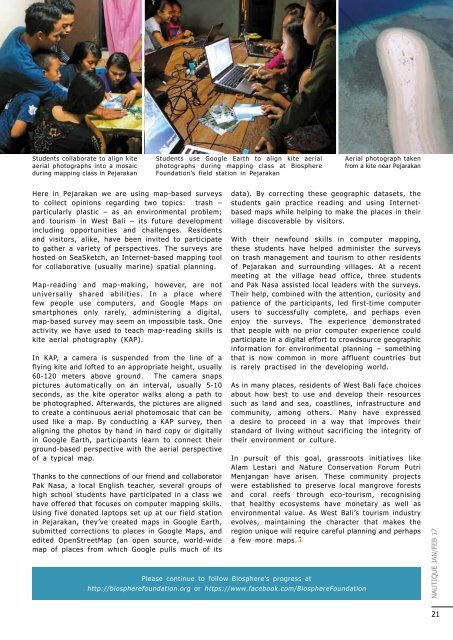
Students collaborate to align kite<br />
aerial photographs into a mosaic<br />
during mapping class in Pejarakan<br />
Students use Google Earth to align kite aerial<br />
photographs during mapping class at Biosphere<br />
Foundation’s field station in Pejarakan<br />
Aerial photograph taken<br />
from a kite near Pejarakan<br />
Here in Pejarakan we are using map-based surveys<br />
to collect opinions regarding two topics: trash –<br />
particularly plastic – as an environmental problem;<br />
and tourism in West Bali – its future development<br />
including opportunities and challenges. Residents<br />
and visitors, alike, have been invited to participate<br />
to gather a variety of perspectives. The surveys are<br />
hosted on SeaSketch, an Internet-based mapping tool<br />
for collaborative (usually marine) spatial planning.<br />
Map-reading and map-making, however, are not<br />
universally shared abilities. In a place where<br />
few people use computers, and Google Maps on<br />
smartphones only rarely, administering a digital,<br />
map-based survey may seem an impossible task. One<br />
activity we have used to teach map-reading skills is<br />
kite aerial photography (KAP).<br />
In KAP, a camera is suspended from the line of a<br />
flying kite and lofted to an appropriate height, usually<br />
60-120 meters above ground. The camera snaps<br />
pictures automatically on an interval, usually 5-10<br />
seconds, as the kite operator walks along a path to<br />
be photographed. Afterwards, the pictures are aligned<br />
to create a continuous aerial photomosaic that can be<br />
used like a map. By conducting a KAP survey, then<br />
aligning the photos by hand in hard copy or digitally<br />
in Google Earth, participants learn to connect their<br />
ground-based perspective with the aerial perspective<br />
of a typical map.<br />
Thanks to the connections of our friend and collaborator<br />
Pak Nasa, a local English teacher, several groups of<br />
high school students have participated in a class we<br />
have offered that focuses on computer mapping skills.<br />
Using five donated laptops set up at our field station<br />
in Pejarakan, they’ve created maps in Google Earth,<br />
submitted corrections to places in Google Maps, and<br />
edited OpenStreetMap (an open source, world-wide<br />
map of places from which Google pulls much of its<br />
Please continue to follow Biosphere’s progress at<br />
data). By correcting these geographic datasets, the<br />
students gain practice reading and using Internetbased<br />
maps while helping to make the places in their<br />
village discoverable by visitors.<br />
With their newfound skills in computer mapping,<br />
these students have helped administer the surveys<br />
on trash management and tourism to other residents<br />
of Pejarakan and surrounding villages. At a recent<br />
meeting at the village head office, three students<br />
and Pak Nasa assisted local leaders with the surveys.<br />
Their help, combined with the attention, curiosity and<br />
patience of the participants, led first-time computer<br />
users to successfully complete, and perhaps even<br />
enjoy the surveys. The experience demonstrated<br />
that people with no prior computer experience could<br />
participate in a digital effort to crowdsource geographic<br />
information for environmental planning – something<br />
that is now common in more affluent countries but<br />
is rarely practised in the developing world.<br />
As in many places, residents of West Bali face choices<br />
about how best to use and develop their resources<br />
such as land and sea, coastlines, infrastructure and<br />
community, among others. Many have expressed<br />
a desire to proceed in a way that improves their<br />
standard of living without sacrificing the integrity of<br />
their environment or culture.<br />
In pursuit of this goal, grassroots initiatives like<br />
Alam Lestari and Nature Conservation Forum Putri<br />
Menjangan have arisen. These community projects<br />
were established to preserve local mangrove forests<br />
and coral reefs through eco-tourism, recognising<br />
that healthy ecosystems have monetary as well as<br />
environmental value. As West Bali’s tourism industry<br />
evolves, maintaining the character that makes the<br />
region unique will require careful planning and perhaps<br />
a few more maps.<br />
http://biospherefoundation.org or https://www.facebook.com/BiosphereFoundation<br />
NAUTIQUE JAN/FEB 17<br />
21