

Hand
TWP_HM_Article_Mar_Apr_2017
TWP_HM_Article_Mar_Apr_2017

Create successful ePaper yourself
Turn your PDF publications into a flip-book with our unique Google optimized e-Paper software.
page that displays statistics on the account holder’s<br />
finds and links to their most recent records. One<br />
just-for-fun feature is a lifelist that auto-updates<br />
based on recorded observations. Users receive<br />
achievement badges for reaching certain levels such<br />
as number of records and species.<br />
The project team continues to add new interactive<br />
and educational features all the time to keep the site<br />
fun and engaging. A recent example is the ability for<br />
users to graph their own species encounter rates.<br />
Users can also view other herp observations, minus<br />
latitude and longitude coordinates, from around<br />
the world as they are recorded, provided that the<br />
individual has not chosen to hide the record from<br />
public view.<br />
Mining the data<br />
In return for the features listed above, users agree<br />
up front to make their records freely available to<br />
HerpMapper’s Data Partners — something that<br />
sets HerpMapper apart from many other citizen<br />
science projects. These vetted groups use the data<br />
for research, conservation and preservation purposes.<br />
Only the individual user and the three project<br />
administrators have access to all the data within a<br />
user’s account, while HerpMapper Partner organizations<br />
are granted access to data that falls specifically<br />
within their geographic work area or project scope.<br />
For example, the Texas Parks and Wildlife Department<br />
can only access data from Texas.<br />
Other users of HerpMapper and the general public<br />
can see the basic information in submitted records,<br />
but they do not have access to the exact location<br />
where the herp was spotted. To protect herp populations<br />
and habitats, records list the general location<br />
by county, province or other equivalent geopolitical<br />
unit. Nevertheless, these observations, whether<br />
from targeted searches or incidental encounters,<br />
can provide valuable insight into species’ distributions,<br />
habitats occupied and activity patterns.<br />
Accuracy counts<br />
HerpMapper data are constantly reviewed for<br />
identification accuracy, both by moderators and by<br />
actively involved citizens. All users can flag records<br />
with suspected errors using a built-in button or<br />
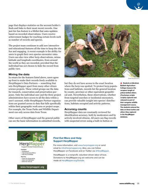
Credit: Vanessa Lane<br />
Students at Abraham<br />
Baldwin Agriculture<br />
College measure the<br />
carapace length of<br />
yellow-bellied sliders<br />
(Trachemys scripta<br />
scripta ) captured and<br />
released as part of<br />
their nongame wildlife<br />
management course.<br />
The students entered the<br />
data on these turtles and<br />
others they captured<br />
in the HerpMapper<br />
database.<br />
Find Out More and Help<br />
Support HerpMapper<br />
For more information, visit www.herpmapper.org or send<br />
email to info@herpmapper.org. Also, you can follow<br />
HerpMapper on Facebook and on Twitter via @HerpMapper.<br />
HerpMapper is a nonprofit, volunteer-driven labor-of-love.<br />
Donations to HerpMapper.org are welcome and can be<br />
made at HerpMapper.org/Donate.<br />
© The Wildlife Society<br />
www.wildlife.org<br />
35