Publications - Norsar
Publications - Norsar
Publications - Norsar

Create successful ePaper yourself
Turn your PDF publications into a flip-book with our unique Google optimized e-Paper software.
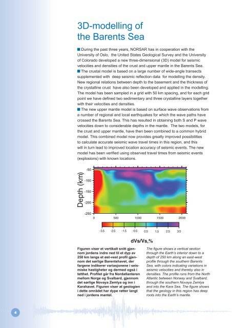
3D-modelling of<br />
the Barents Sea<br />
During the past three years, NORSAR has in cooperation with the<br />
University of Oslo, the United States Geological Survey and the University<br />
of Colorado developed a new three-dimensional (3D) model for seismic<br />
velocities and densities of the crust and upper mantle in the Barents Sea.<br />
The crustal model is based on a large number of wide-angle transects<br />
supplemented with deep seismic reflection data for modelling the density.<br />
New regional relations between depth to the basement and the thickness of<br />
the crystalline crust have also been developed and applied in the modelling.<br />
The model has been sampled in a grid with 50 km spacing, and for each grid<br />
point we have defined two sedimentary and three crystalline layers together<br />
with their velocities and densities.<br />
The new upper mantle model is based on surface wave observations from<br />
a number of regional and local earthquakes for which the wave paths have<br />
crossed the Barents Sea. This has resulted in obtaining both S and P wave<br />
velocities down to considerable depths in the mantle. The two models, for<br />
the crust and upper mantle, have then been combined to a common hybrid<br />
model. This combined model now provides greatly improved possibilities<br />
to calculate accurate seismic wave travel times in this region, and this<br />
will in turn lead to improved location accuracy of seismic events. The new<br />
model has been verified using observed travel times from seismic events<br />
(explosions) with known locations.<br />
Figuren viser et vertikalt snitt gjennom<br />
jordens indre ned til et dyp av<br />
250 km langs et øst-vest profil gjennom<br />
det sørlige Barentshavet, der<br />
fargene indikerer variasjonene i seismiske<br />
hastigheter og dermed også i<br />
tetthet. Profilet går fra Nordatlanteren<br />
mellom Norge og Svalbard, gjennom<br />
det sørlige Novaya Zemlya og inn i<br />
Karahavet. Figuren viser at geologien<br />
i dette området har dype røtter langt<br />
ned i jordens mantel.<br />
The figure shows a vertical section<br />
through the Earth’s interior down to a<br />
depth of 250 km along an east-west<br />
profile through the southern Barents<br />
Sea, with colors indicating variations in<br />
seismic velocities and thereby also in<br />
densities. The profile runs from the North<br />
Atlantic between Norway and Svalbard,<br />
through the southern Novaya Zemlya<br />
and into the Kara Sea. The figure shows<br />
that the geology in this region has deep<br />
roots into the Earth’s mantle.