

2D & 3D geospatial information fusion and visualization software

Create successful ePaper yourself
Turn your PDF publications into a flip-book with our unique Google optimized e-Paper software.
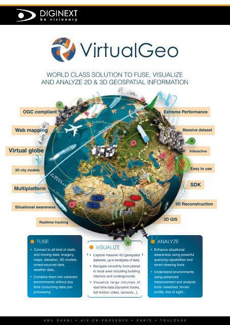
VirtualGeo<br />
WORLD CLASS SOLUTION TO FUSE, VISUALIZE<br />
AND ANALYZE <strong>2D</strong> & <strong>3D</strong> GEOSPATIAL INFORMATION<br />
OGC compliant<br />
Extreme Performance<br />
Web mapping<br />
Massive dataset<br />
Virtual globe<br />
Interactive<br />
<strong>3D</strong> city models<br />
Easy to use<br />
Multiplatform<br />
SDK<br />
Situational awareness<br />
<strong>3D</strong> Reconstruction<br />
Realtime tracking<br />
<strong>3D</strong> GIS<br />
; FUSE<br />
• Connect to all kind of static<br />
<strong>and</strong> moving data: imagery,<br />
maps, elevation, <strong>3D</strong> models,<br />
crowd-sourced data,<br />
weather data...<br />
; VISUALIZE • Explore massive 4D <strong>geospatial</strong> datasets, up to terabytes of data.<br />
• Navigate smoothly from planet<br />
to local area including building<br />
• Enhance situational<br />
awareness using powerful<br />
querying capabilities <strong>and</strong><br />
smart drawing tools<br />
interiors <strong>and</strong> undergrounds.<br />
• Combine them into coherent<br />
environments without any<br />
time consuming data preprocessing<br />
• Visualize large volumes of<br />
real-time data (dynamic tracks,<br />
full motion video, sensors...).<br />
; ANALYZE<br />
• Underst<strong>and</strong> environments<br />
using advanced<br />
measurement <strong>and</strong> analysis<br />
tools: viewshed, terrain<br />
profi le, line of sight...<br />
A B U D H A B I • A I X - E N - P R O V E N C E • P A R I S • T O U L O U S E
VirtualGeo<br />
; BENEFITS<br />
COST-EFFECTIVE<br />
• Enjoy a faster development process of your<br />
<strong>geospatial</strong> applications thanks to a comprehensive<br />
"out of the box" set of fi eld-proven components<br />
FLEXIBLE<br />
• Integrate VirtualGeo as you want: work with your<br />
preferred programming language <strong>and</strong> GUI toolkit,<br />
<strong>and</strong> target all major platforms<br />
INTEROPERABLE<br />
• Instantly fuse datasets in many different civilian <strong>and</strong><br />
military formats, projections <strong>and</strong> geodetic references<br />
OFFLINE & ONLINE<br />
• Connect your maps to local data repositories as<br />
well as <strong>geospatial</strong> databases <strong>and</strong> OGC compliant<br />
web-services<br />
HIGHEST PERFORMANCE<br />
• Visualize massive <strong>geospatial</strong> datasets, up to<br />
terabytes of data, <strong>and</strong> track thous<strong>and</strong>s of dynamic<br />
objects in real-time<br />
<strong>3D</strong> CITY EXPLORATION<br />
• Explore <strong>and</strong> edit high-resolution <strong>3D</strong> urban<br />
environments, including building interiors <strong>and</strong><br />
undergrounds<br />
SCALABLE<br />
• Run your applications on any desktop or mobile<br />
device with a full control of the trade-off between<br />
quality <strong>and</strong> CPU/memory usage<br />
; PACKAGING<br />
• SDK<br />
A complete <strong>and</strong> easy-to-use kit for rapid development of<br />
<strong>geospatial</strong> applications on desktops <strong>and</strong> mobile devices<br />
• WEB<br />
An easy-to-use <strong>and</strong> cross-browser kit for rapid development<br />
of advanced web-based <strong>geospatial</strong> applications<br />
• STUDIO<br />
A powerful <strong>and</strong> user friendly application to quickly prepare,<br />
explore <strong>and</strong> publish effi cient maps<br />
; FIELDS OF APPLICATION<br />
DEFENCE<br />
• Mission planning<br />
• Comm<strong>and</strong> & control system<br />
• Battle management system<br />
• Unmanned system<br />
• Training system<br />
SAFETY & SECURITY<br />
• Protection planning<br />
• Emergency response operations<br />
• Surveillance system<br />
• Critical infrastructure protection<br />
• Border control system<br />
URBAN & TERRITORY PLANNING<br />
• Gaining public support for proposal<br />
• Impact assessment<br />
• Virtual online tour of future project<br />
• Urban project communication<br />
• Environmental data visualisation<br />
For more <strong>information</strong>, please contact DIGINEXT<br />
virtualgeo@diginext.fr<br />
sales@diginext.fr<br />
www.virtual-geo.com<br />
www.diginext.fr<br />
+ 33 561 176 690<br />
5 Rue Brindejonc des Moulinais<br />
BP 15872<br />
31506 Toulouse Cedex 5<br />
France<br />
A B U D H A B I • A I X - E N - P R O V E N C E • P A R I S • T O U L O U S E