

TASLAK1

You also want an ePaper? Increase the reach of your titles
YUMPU automatically turns print PDFs into web optimized ePapers that Google loves.
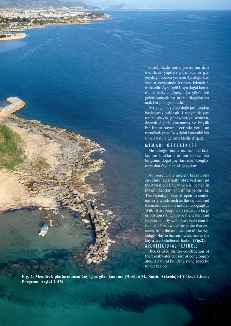
Günümüzde antik yerleşime dair<br />
mendirek yapıları yarımadanın güneydoğu<br />
ucunda yer alan Aynalıgöl koyunun<br />
çevresinde kısmen izlenebilmektedir.<br />
Aynalıgöl koyu doğal konumu<br />
itibariyle güneydoğu yönünden<br />
gelen samyeli ve imbat rüzgârlarına<br />
açık bir pozisyondadır.<br />
Aynalıgöl koyunun doğu kesiminden<br />
başlayarak yaklaşık 1 radyanlık yay<br />
uzunluğuyla güneybatıya uzanan,<br />
önemli ölçüde korunmuş ve büyük<br />
bir kısmı suyun üzerinde yer alan<br />
mendirek yapısı koy içini korunaklı bir<br />
liman haline getirmektedir (Fig.2).<br />
M i M A r i Ö z e l l i k l e r<br />
Mendireğin inşası aşamasında kullanılan<br />
blokların temini noktasında<br />
bölgenin doğal yapıtaşı olan konglomeradan<br />
faydalanıldığı açıktır.<br />
At present, the ancient breakwater<br />
structure is partially observed around<br />
the Aynalıgöl Bay, which is located in<br />
the southeastern end of the peninsula.<br />
The Aynalıgöl Bay is open to southeasterly<br />
winds such as the samiel, and<br />
the imbat due to its natural topography.<br />
With its arc length of 1 radian, its larger<br />
portion rising above the water, and<br />
its particularly well-preserved condition,<br />
the breakwater structure that extends<br />
from the east section of the Aynalıgöl<br />
Bay to the southwest, makes the<br />
bay a well-sheltered harbor (Fig.2).<br />
A r c h i t e c t u r A l F e A t u r e s<br />
Blocks used for the construction of<br />
the breakwater consist of conglomerates,<br />
a natural building stone specific<br />
to the region.<br />
Fig. 2: Mendirek platformunun koy içine göre konumu (Bezdan M., Sualtı Arkeolojisi Yüksek Lisans<br />
Programı Arşivi-2015)