

5856_LH - Living Here - MARCH 2017_WEB

You also want an ePaper? Increase the reach of your titles
YUMPU automatically turns print PDFs into web optimized ePapers that Google loves.
ENVIRONMENT<br />
LIVING<br />
HERE<br />
<strong>MARCH</strong> <strong>2017</strong><br />
Have your say!<br />
Important information about the<br />
<strong>2017</strong>/18 Annual Plan inside.<br />
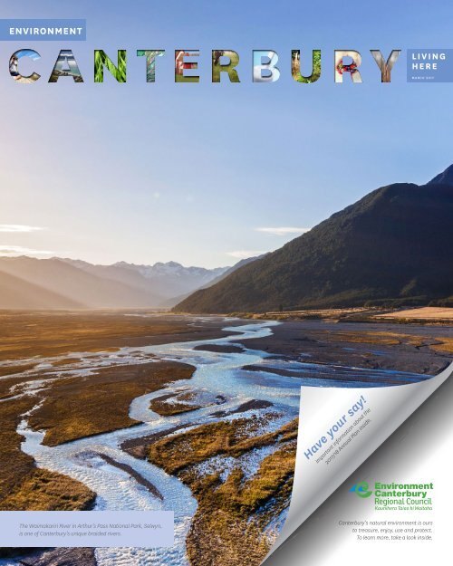
The Waimakariri River in Arthur’s Pass National Park, Selwyn,<br />
is one of Canterbury’s unique braided rivers.<br />
Canterbury’s natural environment is ours<br />
to treasure, enjoy, use and protect.<br />
To learn more, take a look inside.
Caring for our<br />
landscape<br />
W<br />
hen you think of pest control, ‘Christmas trees’ may not be<br />
high on the list of pests you think of. Self-sown pine and<br />
other conifer trees cause significant issues for New Zealand’s<br />
natural biodiversity. Their<br />
‘weedy’ tendencies give<br />
rise to wilding spread<br />
so you’ll often see them<br />
referred to as wilding<br />
pines. They are very hardy<br />
trees that produce lots<br />
of light, wind-dispersed<br />
seeds from an early age.<br />
They can invade and take<br />
over native habitats and<br />
species, and may threaten<br />
the whole of the South<br />
A contractor undertaking on-the-ground<br />
wilding pine control.<br />
Island eastern hill and<br />
high country. This year<br />
Environment Canterbury is<br />
undertaking a $4 million wilding control operation over 900,000 hectares,<br />
co-funded and implemented with the Crown, Department of Conservation,<br />
Land Information New Zealand, and land occupiers.<br />
Wilding conifers are continuing to increase in<br />
area at an average rate of about 5-6% per<br />
year – with about 2.6 million hectares in New<br />
Zealand already affected to some extent.<br />
The National Wilding Conifer Management<br />
Strategy 2015-2023, released by the Ministry<br />
for Primary Industries, addresses control<br />
of the pest across the country:<br />
www.wildingconifers.org.nz.<br />
Another introduced pest is gorse, well known for its vast spreads of yellow flowers<br />
across the landscape. Environment Canterbury supports land owners to prevent<br />
infestation of land that is presently free of gorse.<br />
Walking in the Hurunui<br />
T<br />
here are some incredible walks across the Hurunui<br />
district, from coastal walks near Amberley, forest walks in<br />
Hanmer Springs, the Weka Pass Walkway, or if you need<br />
more of a challenge, Mount Grey near Amberley, Mount<br />
Isobel near Hanmer Springs and the St James Conservation Area.<br />
www.visithurunui.co.nz.<br />
To find out about the native birds and plants you could see on your walk,<br />
such as the great-spotted kiwi/roroa, yellowhead/mohua, kākā, kea, or<br />
the endangered orange-fronted parakeet/kākāriki-whero and blue duck/<br />
whio (threatened) – visit www.ecan.govt.nz (nature in your area/Hurunui-<br />
Waiau-zone).<br />
There’s so much to explore<br />
in the Hurunui District.<br />
25%<br />
Around 25% of Canterbury is<br />
affected by wilding conifers.
Uniquely braided<br />
In Canterbury, the seven alpine rivers that contribute 88% of the<br />
flow within the region – Clarence/Waiau Toa, Waiau, Hurunui,<br />
Waimakariri, Rakaia, Rangitata, and Waitaki – are all braided.<br />
Other foothill rivers are also braided or<br />
have braided reaches.<br />
Braided rivers are iconic natural features,<br />
found in only a few places around the<br />
world, such as Alaska, Canada, the<br />
Himalayan region, and New Zealand.<br />
‘Braiding’ refers to the multiple water<br />
channels that flow around gravel islands.<br />
These unique features of the Canterbury<br />
landscape started life during the last major<br />
ice age 25,000 to 10,000 years ago, when<br />
huge glaciers pushed millions of tonnes of<br />
rock off the spine of the Southern Alps. As<br />
the ice began to retreat, streams and rivers<br />
carried this alluvial outwash down the<br />
valleys of the east coast and deposited it<br />
to form flat basins between the mountains<br />
and the coastal plains.<br />
Braided rivers are characterised by their<br />
multiple, shifting channels, varying<br />
flows and shingle substrate. The rivers<br />
are an abundant supply of food and<br />
support many species that can’t be found<br />
anywhere else, including 26 species of<br />
native bird, with the majority classified<br />
as threatened and facing increased<br />
pressures as the natural character of<br />
their home changes.<br />
It is recognised that the habitats provided<br />
by braided river systems are becoming increasingly vulnerable as we<br />
place pressures on them for water use, such as irrigation and hydro<br />
schemes and recreation. They also face pressures from increased<br />
pests, weeds and pollution.<br />
Working together<br />
In February, the Environment Canterbury Council<br />
resolved to make Plan Change 4 of the Land &<br />
Water Regional Plan (the ‘Omnibus’ plan change)<br />
operative. Among other things, this plan change<br />
strengthens the rules regarding removal of<br />
vegetation from braided river beds and defines<br />
those beds to make it easier to understand how<br />
to comply with stock exclusion rules.<br />
Many agencies have come together to ensure<br />
an aligned approach to protecting the braided<br />
rivers. Environment Canterbury, local councils,<br />
Te Rūnanga o Ngāi Tahu, Federated Farmers, the<br />
Ministry for Primary Industries, Land Information<br />
New Zealand, Department of Conservation,<br />
Braided River Aid (Braid), Forest & Bird and many<br />
other local groups are already driving work on<br />
the ground that can be built on for the future.<br />
Specific management plans are also being<br />
considered for individual rivers, like the Hurunui.<br />
The Canterbury Water Management Strategy (CWMS) aims to halt the<br />
decline through its targets and goals with its focus on the integration<br />
of water and land management including the protection of indigenous<br />
biodiversity and water quality.<br />
This is also integrated with kaitiakitanga<br />
or guardianship by Ngāi Tahu which<br />
applies to the ecological health of all<br />
waterways.<br />
A number of projects are underway<br />
to protect and enhance braided-river<br />
ecosystems and species. Such projects<br />
include, weed control (e.g. preventing<br />
weeds, surveillance, removal); sustained<br />
predator control; rules for habitat<br />
protection (e.g. legal protection of<br />
waterways, firewood cutting rules);<br />
adequate environmental flows to<br />
sustain fauna; protected areas networks<br />
(e.g. to protect a representative range<br />
of rivers); community conservation<br />
initiatives; recreation management (e.g.<br />
restricted access for four wheel drives);<br />
communication and education for river<br />
users (e.g. improved signage); subregional<br />
(zone) action plans; inventories<br />
of current state; fencing of stock to keep<br />
them out of waterways. Many of these<br />
activities are methods for achieving the<br />
CWMS targets.<br />
The unique protection issues of<br />
our braided rivers is explained at<br />
www.ecan.govt.nz/cwms-braided-rivers.
Waimakariri<br />
River<br />
Before European settlement the<br />
Waimakariri River was a vast and<br />
unconstrained braided river that<br />
frequently overflowed surrounding land,<br />
including through the site of present day<br />
Christchurch.<br />
Over the past 150 years, people have<br />
worked to contain the mighty river<br />
and prevent it from overflowing. The<br />
Waimakariri River Regional Park was<br />
originally created as a way of managing<br />
the Environment Canterbury-owned river<br />
protection land along the length of the<br />
Waimakariri River.<br />
Today, the Waimakariri River Regional<br />
Park covers 15,000 hectares of river and<br />
river’s edge land divided up into several<br />
park areas that cater for activities ranging<br />
from mountain biking, picnicking, horse<br />
riding, walking, gamebird hunting, fishing<br />
and more.<br />
Visit www.ecan.govt.nz<br />
(under Your Region,<br />
Lake Tekapo<br />
<strong>Living</strong> in Canterbury,<br />
Regional Parks).<br />
Waimakariri<br />
River
PM10 stands for Particulate Matter measuring under 10 microns in<br />
diameter. These particles can deposit in our airways, which can cause<br />
serious health effects. Environment Canterbury monitors for PM10, PM2.5<br />
(the much finer subset of PM10 created from combustion), carbon<br />
monoxide, and in some places sulphur dioxide.<br />
Good stuff:<br />
clearing the air<br />
A<br />
s we head into autumn the issue of how we can keep the air clear<br />
while remaining warm in our homes over winter, raises its head.<br />
We know that home heating is the main cause of winter air<br />
pollution in the areas where air quality is monitored in Canterbury. Environment<br />
Canterbury is tasked with providing the strategies and rules to help the<br />
community to improve air quality so we can all breathe cleaner, healthier air.<br />
What does this mean for the average household? First up, people need to be<br />
able to keep warm during winter. But the community has also said it wants to<br />
have clean air to breath. So to help achieve those goals we’re focusing on helping<br />
people burn better, and upgrade to better burners.<br />
This winter we’ll again be providing advice about how to light a clean-burning, hot<br />
fire. Scientific evidence tells us that poor wood burning technique and inefficient<br />
wood burners are responsible for the majority of winter pollution in our region.<br />
That’s why we are encouraging the use of Energy Star® qualified heat pumps<br />
or modern ultra-low emission burners that emit less smoke than older, more<br />
polluting burners.<br />
The World Health Organisation provides air quality guidelines and, consistent<br />
with this, the Ministry for the Environment has set the National Environment<br />
Standard for Air Quality (NESAQ), which allows for only one high-pollution<br />
day a year from 2020. PM10 levels cannot exceed 50 micrograms per cubic<br />
metre over a 24 hour period. When we exceed this guideline, we record it as a<br />
‘high pollution’ event. Our targets for the number of high pollution days that is<br />
acceptable are very low – and in some areas there is a lot of work to do still to<br />
reach them.<br />
The places we monitor are where pollution is known to be highest. If<br />
concentrations in the worst areas are below the national guidelines then we can<br />
be confident they are below across the town or city. Environment Canterbury’s<br />
role is to help people comply with the rules as soon as possible so we are<br />
collectively helping clear up the air.<br />
There are a range of other heating options depending on your property type,<br />
current burner, where you live etc. There are many variables allowed for in the<br />
Canterbury Air Plan so if you need advice, check out the Environment Canterbury<br />
website to see what applies in your area, or call us.<br />
What’s on in the region<br />
The Mackenzie A&P Highland Show will be held on 17 April at the Mackenzie<br />
A&P Showgrounds, 1 Gillingham Street, Fairlie from 8:00am - 6:00pm.<br />
For home and farm produce, wine and home brew, flowers, art, crafts,<br />
jewellery, sculpture, photography, dog trials, highland dancing, piping and<br />
solo drumming, alpacas, wearable arts, equestrian, sheep, wool, cattle, goats<br />
and poultry and much more. Visit the show’s website for more information<br />
www.mackenzieshow.co.nz.
Meet the locals<br />
ALWAYS WEAR<br />
YOUR LIFE<br />
JACKET!<br />
Canterbury is home to about 9% of the total boating population of New Zealand. That’s around 110,000 boaties (and approximately 31,680<br />
powerboats). New Navigation Safety Bylaw is there to keep all these locals safe – see www.ecan.govt.nz/navsafety.<br />
Jim Dilley is the<br />
Harbourmaster for<br />
Canterbury. Back in the<br />
‘80s and ‘90s Jim used to<br />
visit Lyttelton on container<br />
ships before finishing up his<br />
career at sea and moving to<br />
New Zealand permanently.<br />
Jim says Lyttelton’s one of<br />
his favourite places in the<br />
world, a gritty community<br />
where a spade is a spade<br />
and the people take<br />
you at face value.<br />
Digital connectivity<br />
In December 2015 Spark NZ partnered with the Canterbury<br />
Mayoral Forum and announced that it would bring forward<br />
its roll out of 4G fast mobile broadband, to be completed by<br />
December 2016. Spark NZ prioritised $14million of investment<br />
into Canterbury and only mother nature could prevent them from<br />
reaching their target, with just the Hundalee site being incomplete<br />
due to the November 2016 earthquake breaking a guy wire on the<br />
mast. Spark also went over and above the project specs by putting<br />
in additional sites coverage and additional capacity.<br />
Thank you<br />
Makarini Rupene grew up in<br />
the Tuahiwi pa and Kaiapoi,<br />
brought up hunting, fishing<br />
and gathering mahinga kai/<br />
natural recourses with his<br />
whanau and elders. This<br />
childhood taught Makarini<br />
the importance of the<br />
environment and its living<br />
ecosystems. Makarini is now<br />
working for Environment<br />
Canterbury as a Parks<br />
Ranger working on our rivers<br />
and the coastline cleaning<br />
up or re-establishing<br />
native areas to enhance<br />
wetlands and ecosystems,<br />
and upholding the bylaws<br />
in the parks. Makarini also<br />
represents his Rūnanga<br />
on a Canterbury Water<br />
Management committee.<br />
As you can see from this<br />
picture, Makarini has also<br />
been involved with the Port<br />
Hills fire fighting efforts.<br />
Above: Community members got together on February 28 to rescue īnaka<br />
(whitebait) and tuna (eels) from the drying Waikirikiri/Selwyn River near Coes Ford.<br />
About 2,500 īnaka and 300 tuna were relocated to Te Waihora/Lake Ellesmere.
Connect with us<br />
<strong>2017</strong>/18 Annual Plan – have your say<br />
It is that time of year when all the councils, including Environment Canterbury, will be asking<br />
the community for feedback on their Annual Plan for the coming financial year (<strong>2017</strong>/18).<br />
Environment Canterbury invites you to give feedback on activity proposed across the<br />
region outlined in our draft Annual Plan.<br />
Your local city or district council will also be asking you for feedback on its Annual Plan.<br />
While Environment Canterbury works closely with city and district councils, we have<br />
different roles so it’s important to engage in both processes if you want to have a say.<br />
For the Environment Canterbury plan:<br />
• Visit www.ecan.govt.nz, view the short summary document and/or the full draft<br />
<strong>2017</strong>/18 Annual Plan and use the online form to send your feedback in<br />
• Email ecinfo@ecan.govt.nz to arrange a time to talk to Councillors in May if you wish.<br />
Please note, the closing date for feedback or to request a time to meet with Councillors is 5pm on Friday 21 April.<br />
P hoto comp etition winner<br />
Some fabulous images of this beautiful region were submitted<br />
to the photo competition run in the last issue of <strong>Living</strong> <strong>Here</strong>.<br />
Thank you to all those who shared them. The winner of the<br />
Fitbit Alta Fitness Wristband is Cindy Merritt of Christchurch,<br />
who took this picture on a walk around Purau Bay.<br />
Join the conversation with Environment Canterbury.<br />
Follow activity, post comments or<br />
contact our Customer Services team.<br />
ecan.govt.nz. 0800 EC INFO or 0800 324 636