Newsfeed_Spring 2017

Create successful ePaper yourself
Turn your PDF publications into a flip-book with our unique Google optimized e-Paper software.
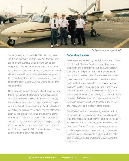
The flight team preparing to take off.<br />
“When you work in a place like Ethiopia, the government<br />
is very protective,” says Dan. “In Ethiopia, there<br />
are no private planes, not just anyone can go out<br />
and get their license.” Because of this, Derek – who<br />
navigated the plane – and Steve had to wear an official<br />
airman’s shirt with the appropriate number of stripes on<br />
the epaulettes. “They don’t care who you are, you have<br />
to look the part,” laughs Dan. “So we made sure they<br />
looked official.”<br />
Once they had donned their official garb each morning,<br />
they’d walk across the tarmac to where their plane<br />
was kept. “This was almost a 30-minute walk away,<br />
but we’d walk by a bunch of huge planes so this part<br />
was actually really interesting,” says Derek, who did the<br />
navigating for the pilot of the plane and the data acquisition<br />
for this project. “Once we arrived at the plane –<br />
which was an Aero Turbo Commander, a pressurized<br />
aircraft with a jet turbine engine versus the piston engine<br />
planes we use here – we would take off and be in the<br />
plane all day, usually for 5 to 6 hours, before I’d return<br />
and Steve would download the data.”<br />
Collecting the data<br />
Derek spent each day flying the flight path he and Steve<br />
had planned. Not only was the project about data<br />
acquisition and interpretation, but there was a knowledge<br />
transfer component that both Steve and Derek<br />
participated in and enjoyed. “There were usually a few<br />
government staff in the plane with me while we flew,”<br />
says Derek. “I’d be training them on how to operate<br />
the LiDAR system. They would operate it and I’d walk<br />
them through the steps and oversee their work. It felt<br />
like we were pioneering the industry of LiDAR in Ethiopia<br />
because LiDAR data acquisition was new for them. But<br />
they were all super smart people, really willing to learn,<br />
and I really enjoyed this aspect of the project.”<br />
Once Derek had flown the entire flight plan for the day,<br />
he would return to base where Steve would begin the<br />
data processing. “Once I received the data, I’d ensure it<br />
was entered into the georeferenced, unclassified point<br />
cloud,” says Steve. “For security reasons, we had to<br />
do all data processing in the government offices. We<br />
trained several of their staff to work through the data<br />
from GNSS and Inertial processing to computing the<br />
point cloud.”<br />
MCSL Quarterly Newsletter Fall Issue <strong>2017</strong><br />
Page 3