

Caribbean Compass Yachting Magazine - May 2018
Welcome to Caribbean Compass, the most widely-read boating publication in the Caribbean! THE MOST NEWS YOU CAN USE - feature articles on cruising destinations, regattas, environment, events...
Welcome to Caribbean Compass, the most widely-read boating publication in the Caribbean! THE MOST NEWS YOU CAN USE - feature articles on cruising destinations, regattas, environment, events...

You also want an ePaper? Increase the reach of your titles
YUMPU automatically turns print PDFs into web optimized ePapers that Google loves.
— Continued from previous page<br />
As it was, a slightly more southerly path close to St. Croix spared Tortola from a<br />
repeat performance, though the relief cat only just survived, tied up on one of the few<br />
remaining docks in Nanny Cay at the time, subjected to swells that had the mooring<br />
lines popping all night and into the next day. A slightly more northerly track and it<br />
could have been so different.<br />
Local boats have strategies to deal with hurricanes which commonly involve tying<br />
up in the nearest “hurricane hole” of choice, which can work as long as the storm is<br />
a moderate one, or not a direct hit. The faster commercial vessels have a tendency<br />
to leave port in advance of a westward-moving storm that seems likely to pass<br />
through the Leewards. They run south and wait offshore in the lee of Martinique,<br />
monitoring the progress of the storm to decide if they have to keep heading farther<br />
south or not (you can see them on AIS).<br />
Perhaps it goes with out saying that if you can stay out of the hurricane zone during<br />
the hurricane season from June 1st to November 30th, you might have a more<br />
relaxed summer. But then again, you will also miss the quieter anchorages and<br />
(generally) calmer seas. Another of life’s wonderful dilemmas…<br />
more sure of your position.<br />
Hurricanes can be plotted in similar fashion. With the predicted track or the direction<br />
of movement in its center, draw a 10-degree cone extending from the position<br />
NOAA weather gives for the center of the hurricane. When the hurricane is 600 miles<br />
away, the cone is 105 miles wide; when it is 300 miles away, the width of the cone<br />
will be 35 miles wide, etcetera. This will allow you to predict the probable strike area,<br />
and the danger zone.<br />
Selections from the Archives. For more thoughts on hurricane preparation, see the<br />
following articles in the <strong>Compass</strong> archives:<br />
• ‘Hurricane Survival Strategy’, by David H. Lyman<br />
(www.caribbeancompass.com/online/may13compass_online.pdf, page 22)<br />
• ‘Preparing for a Hurricane’, by David H. Lyman<br />
(www.caribbeancompass.com/online/june13compass_online.pdf, page 27)<br />
• ‘Windwards During Hurricane Season? Thoughts for Cruisers Planning to<br />
Remain’, by The Scottish Captain<br />
(www.caribbeancompass.com/online/july15compass_online.pdf, page 39)<br />
• ‘Managing Hurricane-Season Risk for Boats Stored in the <strong>Caribbean</strong>’, by Don<br />
Street. (www.caribbeancompass.com/online/march18compass_online.pdf, page 24)<br />
The Cone of Probability<br />
by Don Street<br />
Since hurricanes approaching the <strong>Caribbean</strong> virtually never alter course more<br />
than five degrees in 24 hours, I have formulated “Street’s Law of Probability”.<br />
In the Dark Ages before the arrival of electronic navigation, making landfall in fog<br />
or in periods of poor visibility, with no sun sights available, was difficult. We homed<br />
in on, or tried to fix our position with, radio DF bearings. A bearing was taken, and<br />
the experienced navigator knew he did not have an exact bearing but rather a cone<br />
of probability. The size of the cone varied according to electrical reception, sea conditions,<br />
equipment available and the abilities of the DF operator. The cone could be as<br />
little as three to five degrees or as much as ten or more degrees. When you were<br />
farther out at sea the cone could be quite large, but as you approached the DF station<br />
the width of the cone became smaller and smaller, and you became more and<br />
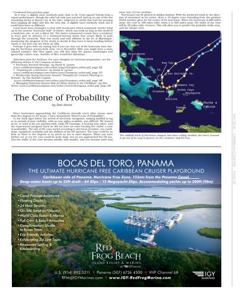
The oddball track of Hurricane Joaquin has been widely studied; the storm seemed<br />
to go out of its way to pounce on the container ship El Faro<br />
BOCAS DEL TORO, PANAMA<br />
THE ULTIMATE HURRICANE FREE CARIBBEAN CRUISER PLAYGROUND<br />
<strong>Caribbean</strong> side of Panama. Hurricane Free Zone. 133nm from the Panama Canal.<br />
Deep water basin up to 25ft draft – 84 Slips / 12 Megayacht Slips. Accommodating yachts up to 300ft (90m)<br />
MAY <strong>2018</strong> CARIBBEAN COMPASS PAGE 29<br />
• Canal Passage Assistance<br />
• Floating Docks<br />
• 24 Hour Security<br />
• On-Site Sundries/Grocery<br />
• World Class Resort & Marina<br />
• Full Crew & Resort Amenities<br />
• Complimentary Shuttle<br />
to Bocas Town<br />
• Eco-Friendly Activities<br />
• Exhilarating Zip Line Tours<br />
• Renowned Surfing &<br />
Kiteboarding<br />
U.S. (954) 892 5211 Panama (507) 6726 4500 VHF Channel 68<br />
RFM@IGYMarinas.com www.IGY-RedFrogMarina.com


