1 - Insight - Bart De Lathouwer - Model for Underground Data Definition and Integration (MUDDI)

Create successful ePaper yourself
Turn your PDF publications into a flip-book with our unique Google optimized e-Paper software.
®<br />
<strong>Model</strong> <strong>for</strong> <strong>Underground</strong> <strong>Data</strong><br />
<strong>De</strong>finition <strong>and</strong> <strong>Integration</strong><br />
(<strong>MUDDI</strong>)<br />
Briefing <strong>for</strong> Newcastle Innovation Festival<br />
<strong>Bart</strong> <strong>De</strong> <strong>Lathouwer</strong>, Josh Lieberman, George Percivall, OGC<br />
Alan Leidner, FCNY<br />
July 2018<br />
Copyright © 2018 Open Geospatial Consortium
The Open Geospatial Consortium<br />
Not-<strong>for</strong>-profit, international voluntary consensus st<strong>and</strong>ards<br />
organization; leading open innovation <strong>for</strong> geospatial data<br />
• Founded in 1994<br />
• 525+ member organizations<br />
• 100 innovation initiatives<br />
• 48 Open St<strong>and</strong>ards<br />
• 230 OGC certified products<br />
• Thous<strong>and</strong>s of implementations<br />
• Enabling access to 100K+ datasets<br />
OGC®<br />
Copyright © 2017 Open Geospatial Consortium<br />
2
The OGC Mission<br />
Global <strong>for</strong>um <strong>for</strong> collaboration of developers <strong>and</strong><br />
users of spatial data products <strong>and</strong> services<br />
Advance development of international st<strong>and</strong>ards <strong>for</strong><br />
geospatial interoperability.<br />
OGC®<br />
Copyright © 2017 Open Geospatial Consortium 3
Value of OGC Participation<br />
• Achieve technical<br />
agreement on<br />
interoperability challenges<br />
• Networking, partnership<br />
development<br />
• <strong>Insight</strong> into emerging<br />
technologies <strong>and</strong> markets<br />
• Unique ability to share cost<br />
/ resources in solving<br />
interoperability challenges<br />
OGC®<br />
Copyright © 2017 Open Geospatial Consortium 4
OGC CityGML <strong>for</strong> Urban Applications<br />
OGC Used NYC Open <strong>Data</strong> to build CityGML models<br />
CityGML models <strong>for</strong> 3D visualization<br />
<strong>and</strong> analysis based on semantics<br />
Source: http://www1.Boston.gov/site/doitt/initiatives/3d-building.page<br />
• Urban Planning / Operations<br />
• Emergency Mgt / Response<br />
• Transportation / Routing / Logistics<br />
• Indoor navigation<br />
• Retail Site analysis<br />
• Sustainable / Green Communities<br />
• City Services Management<br />
• Noise abatement<br />
• Telecommunications placement<br />
• Many other uses…<br />
OGC®<br />
© 2016 Open Geospatial Consortium
Moving <strong>Underground</strong><br />
• CityGML is a mature st<strong>and</strong>ard <strong>for</strong> above ground<br />
– <strong>Data</strong> model st<strong>and</strong>ard defined<br />
– <strong>Data</strong>sets widely available.<br />
– Software implementations of st<strong>and</strong>ard to exploit data model<br />
– Maturity allows focus on data quality <strong>and</strong> efficiency<br />
• <strong>Underground</strong> Infrastructure is the place to be now.<br />
– The New Frontier of modeling the entire urban manmade <strong>and</strong><br />
natural environment.<br />
– Add to CityGML to model the complete urban environment<br />
– Huge cost efficiencies will be achievable<br />
OGC®<br />
Copyright © 2017 Open Geospatial Consortium
<strong>Underground</strong> Infrastructure In<strong>for</strong>mation (UGII)<br />
– Current State of Affairs –<br />
• Present UGII data quality is poor<br />
– Different data models<br />
– Stored in different ways<br />
– Different geometry <strong>and</strong> semantics<br />
• Inability to exchange UGI data<br />
– Maintainers have different purposes<br />
– Ownership, governance challenges<br />
– Interoperability issues<br />
• Costs of UGII failures are recognized<br />
– Routine excavations can be disastrous<br />
– Inefficiencies in construction<br />
– Unable to predict cascading failures<br />
OGC®<br />
OGC <strong>Underground</strong> Concept <strong>De</strong>velopment Study Report<br />
http://docs.opengeospatial.org/per/17-048.html<br />
© 2017 Open Geospatial Consortium
Catastrophes coming from underground<br />
NYC steampipe<br />
explosion<br />
Belgian natural gas<br />
pipeline<br />
Steam Pipe Explosion at Lexington Avenue <strong>and</strong><br />
East 41st Street, Manhattan, July 18, 2007<br />
(https://www.flickr.com/photos/lorcanotway/848506700)<br />
July 30, 2004. High-pressure natural gas pipeline ruptured following<br />
recent third party damage: 24 died <strong>and</strong> 150 hospitalised. Damage to<br />
pipeline during the final stages of construction project.<br />
https://en.wikipedia.org/wiki/Ghislenghien<br />
OGC®<br />
OGC underground workshop, Boston
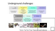
<strong>Underground</strong> In<strong>for</strong>mation (UGI) Projects<br />
1. Concept Study - completed<br />
– Findings <strong>and</strong> Recommendations<br />
2. <strong>MUDDI</strong> <strong>Data</strong> <strong>Model</strong> – conceptual<br />
model drafted, implementations in<br />
progress<br />
– Necessary foundation <strong>for</strong> the Pilot<br />
– FCNY <strong>Model</strong> Workshop July 23-24<br />
3. Pilot Implementation - planned<br />
– <strong>De</strong>velop, Test <strong>and</strong> <strong>De</strong>mo<br />
technology advancements / applications<br />
OGC®<br />
– Provides basis <strong>for</strong> city procurements<br />
© 2017 Open Geospatial Consortium<br />
Source: Singapore L<strong>and</strong> Authority
Use cases <strong>and</strong> case studies<br />
Through the input of RFI responders <strong>and</strong> Workshop<br />
participants, major categories of use case were identified:<br />
• Routine street excavations*<br />
• Emergency response<br />
• Utility maintenance programs<br />
• Large scale construction projects*<br />
• Disaster planning <strong>and</strong> response*<br />
• Smart cities programs.<br />
*Priority use cases <strong>for</strong> initial model <strong>and</strong> pilot<br />
OGC®
Concept Study Recommendations<br />
1. <strong>De</strong>velop interoperable common data models <strong>for</strong><br />
underground infrastructure<br />
2. Conduct research on legal, security, financial, <strong>and</strong> cultural<br />
challenges such as Return on Investment in underground<br />
data<br />
3. Conduct collaborative pilot projects to validate UGI data<br />
models <strong>and</strong> architectures <strong>for</strong> h<strong>and</strong>ling the UGI data.<br />
OGC®<br />
http://docs.opengeospatial.org/per/17-048.html<br />
© 2017 Open Geospatial Consortium
<strong>Underground</strong> <strong>Data</strong> <strong>Model</strong><br />
• <strong>Data</strong> model development based on Concept Study<br />
Recommendations <strong>and</strong> identified existing models<br />
– Funded by the FCNY<br />
– Per<strong>for</strong>med by Josh Lieberman, Tumbling Walls<br />
• Multiple interfaces to a common core exp<strong>and</strong> the interoperable<br />
data exchange <strong>and</strong> integration capabilities of existing vendor /<br />
contractor / utility systems<br />
• <strong>Model</strong> modularity focuses on the essential data elements <strong>for</strong> each<br />
distinct application use case, with a minimal core model to<br />
minimize challenge of initial deployment<br />
• Built first as a conceptual model to promote interoperability across<br />
multiple physical models, e.g. SQL, GML, JSON<br />
• As the basis <strong>for</strong> implementation pilot engagement, a prototype data<br />
model needs to be prepared <strong>for</strong> Pilot CfP.<br />
• <strong>Model</strong> report pending public release. NYC ETL-Plugfest 7/24-25<br />
OGC®<br />
© 2017 Open Geospatial Consortium
<strong>Data</strong> <strong>Integration</strong> Architecture<br />
Diverse <strong>Data</strong><br />
Sources, Systems,<br />
Formats<br />
Water<br />
Power<br />
A&E<br />
Telecom<br />
Unified <strong>Model</strong> with<br />
Multiple Perspectives<br />
Functions<br />
Networks<br />
Structures<br />
Assets<br />
Distinct <strong>Data</strong>-driven<br />
Applications<br />
Disaster<br />
Planning<br />
Large-scale<br />
Construction<br />
Safe<br />
Excavation<br />
Planning,<br />
Investment,<br />
Lifecycle<br />
OGC®<br />
St<strong>and</strong>ard<br />
<strong>Model</strong><br />
Interfaces<br />
• On-dem<strong>and</strong> Query<br />
• Proxy / Cache<br />
• Authoritative Repository<br />
© 2017 Open Geospatial Consortium<br />
Unified /<br />
Harmonized<br />
<strong>Data</strong> Access
UGI3M <strong>Model</strong> Structure<br />
Inputs<br />
Surveys<br />
Sensors<br />
Core<br />
Structures<br />
2D Geom<br />
3D Geom<br />
<strong>Data</strong><br />
Quality<br />
CityGML<br />
BIM - IFC<br />
Network<br />
Graph<br />
Supply<br />
Regions<br />
Control<br />
Function<br />
Network<br />
Structures<br />
Specialized<br />
Structures<br />
Containers<br />
& Supports<br />
Environment<br />
Regions<br />
Engineering<br />
Parameters<br />
Assets<br />
Section<br />
Borehole<br />
Outputs<br />
OGC®<br />
Input / Output<br />
Interfaces<br />
© 2017 Open Geospatial Consortium<br />
Core <strong>Model</strong><br />
Elements
Questions to Ask (of the <strong>Data</strong>)<br />
Queries<br />
3D image of all the UGI elements within 15’ of planned<br />
excavation<br />
Minimum distance between 2 underground utility networks<br />
Major transmission lines as distinguished from distribution<br />
elements<br />
Important control components in a neighborhood<br />
Age, material composition, thickness of the UGI elements<br />
Likely composition, moisture, chemistry of soils<br />
surrounding particular UGI elements<br />
Likely extent of corrosion of these elements, potential<br />
vulnerability to vibration <strong>and</strong> accidental strikes, spatial<br />
extent of network vulnerability<br />
OGC®<br />
© 2017 Open Geospatial Consortium<br />
Interfaces<br />
2D geometry<br />
3D geometry<br />
3D geometry<br />
Network graph<br />
2D geometry<br />
Network control<br />
Network control<br />
Network supply<br />
Asset<br />
Surveys<br />
2D geometry<br />
Section<br />
Asset<br />
Sensor<br />
Network graph
Return on investment in underground data<br />
• Study <strong>and</strong> analysis of costs <strong>and</strong> economic opportunities<br />
related to underground data development<br />
• Benefit tiers:<br />
1. Interoperability costs <strong>for</strong> underground infrastructure related<br />
projects<br />
2. Opportunity Potential of Improved <strong>Data</strong> Quality <strong>and</strong><br />
Completeness <strong>for</strong> <strong>Underground</strong> Infrastructure<br />
3. Opportunity Potential of Improved <strong>Data</strong> Analytics<br />
4. Qualitative Assessment of Benefits of Subterranean<br />
In<strong>for</strong>mation Management <strong>for</strong> Emergencies <strong>and</strong> Disasters<br />
5. Qualitative Assessment of Benefits from the Application of<br />
Subterranean In<strong>for</strong>mation Management <strong>for</strong> Smart City<br />
Projects<br />
• DYI benefits calendar<br />
OGC®
<strong>MUDDI</strong> Workshop<br />
• Conceptual model testing through analytical / simulation<br />
exercises<br />
• Participants invited to contribute sample datasets<br />
(potentially obfuscated) <strong>for</strong> model evaluation<br />
• Software vendors invited to implement <strong>MUDDI</strong> <strong>and</strong><br />
ingest <strong>and</strong> trans<strong>for</strong>m sample datasets into / through<br />
their implementations<br />
• H<strong>and</strong>s-on assessment of draft model with regard to<br />
priority use cases from the concept development study<br />
• Review <strong>and</strong> exercising of draft ROI model<br />
• Refinement of plan <strong>and</strong> roadmap <strong>for</strong> pilot activities<br />
OGC®