

The Engineer's Companion-October Magazine Edition

Create successful ePaper yourself
Turn your PDF publications into a flip-book with our unique Google optimized e-Paper software.
India‟s First Ever Engineer‟s <strong>Magazine</strong> for Placement Preparation<br />
CAT 2017 Slot I Solved<br />
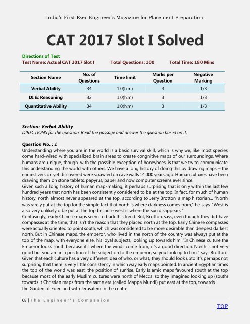
Directions of Test<br />
Test Name: Actual CAT 2017 Slot I Total Questions: 100 Total Time: 180 Mins<br />
Section Name<br />
No. of<br />
Questions<br />
Time limit<br />
Marks per<br />
Question<br />
Negative<br />
Marking<br />
Verbal Ability 34 1:0(h:m) 3 1/3<br />
DI & Reasoning 32 1:0(h:m) 3 1/3<br />
Quantitative Ability 34 1:0(h:m) 3 1/3<br />
Section: Verbal Ability<br />
DIRECTIONS for the question: Read the passage and answer the question based on it.<br />
Question No. : 1<br />
Understanding where you are in the world is a basic survival skill, which is why we, like most species<br />
come hard-wired with specialized brain areas to create congnitive maps of our surroundings. Where<br />
humans are unique, though, with the possible exception of honeybees, is that we try to communicate<br />
this understanding the world with others. We have a long history of doing this by drawing maps – the<br />
earliest version yet discovered were scrawled on cave walls 14,000 years ago. Human cultures have been<br />
drawing them on stone tablets, papyrus, paper and now computer screens ever since.<br />
Given such a long history of human map-making, it perhaps surprising that is only within the last few<br />
hundred years that north has been consistently considered to be at the top. In fact, for much of human<br />
history, north almost never appeared at the top, according to Jerry Brotton, a map historian… ―North<br />
was rarely put at the top for the simple fact that north is where darkness comes from,‖ he says. ―West is<br />
also very unlikely o be put at the top because west is where the sun disappears.‖<br />
Confusingly, early Chinese maps seem to buck this trend. But, Brotton, says, even though they did have<br />
compasses at the time, that isn’t the reason that they placed north at the top. Early Chinese compasses<br />
were actually oriented to point south, which was considered to be more desirable than deepest darkest<br />
north. But in Chinese maps, the emperor, who lived in the north of the country was always put at the<br />
top of the map, with everyone else, his loyal subjects, looking up towards him. ―In Chinese culture the<br />
Emperor looks south because it’s where the winds come from, it’s a good direction. North is not very<br />
good but you are in a position of the subjection to the emperor, so you look up to him,‖ says Brotton.<br />
Given that each culture has a very different idea of who, or what, they should look upto it’s perhaps not<br />
surprising that there is very little consistency in which way early maps pointed. In ancient Egyptian times<br />
the top of the world was east, the position of sunrise. Early Islamic maps favoured south at the top<br />
because most of the early Muslim cultures were north of Mecca, so they imagined looking up (south)<br />
towards it Christian maps from the same era (called Mappa Mundi) put east at the top, towards<br />
the Garden of Eden and with Jerusalem in the centre.<br />
68 | T h e E n g i n e e r ’ s C o m p a n i o n<br />
TO P