Strike-slip tectonics within the SW Baltic Sea and its relationship to ...
Strike-slip tectonics within the SW Baltic Sea and its relationship to ...
Strike-slip tectonics within the SW Baltic Sea and its relationship to ...

You also want an ePaper? Increase the reach of your titles
YUMPU automatically turns print PDFs into web optimized ePapers that Google loves.
96<br />
Block, Christiansø Block; Rønne Graben <strong>and</strong> Arnager<br />
Block (Fig. 2; Vejbæk, 1985; Vejbæk et al., 1994;<br />
Deeks <strong>and</strong> Thomas, 1995).<br />
During <strong>the</strong> Mesozoic, <strong>within</strong> <strong>the</strong> transition area<br />
between <strong>the</strong> STZ <strong>and</strong> <strong>the</strong> TTZ comprising <strong>the</strong> presentday<br />
Bornholm isl<strong>and</strong> <strong>and</strong> <strong>its</strong> surroundings (Fig. 2),<br />
Triassic <strong>to</strong> Jurassic <strong>and</strong> Lower Cretaceous deposition<br />
<strong>to</strong>ok place due <strong>to</strong> extensional phase of basin development<br />
(Gravesen et al., 1982; Schlüter et al., 1997).<br />
<strong>Strike</strong>-<strong>slip</strong> movements resulted in formation of pullapart<br />
basins like <strong>the</strong> Rønne <strong>and</strong> <strong>the</strong> Arnager Grabens<br />
(Liboriussen et al., 1987; Vejbæk, 1985; Ziegler,<br />
1990; Thomas et al., 1993; Deeks <strong>and</strong> Thomas,<br />
1995). Remnants of <strong>the</strong> Mesozoic sedimentary cover<br />
have been drilled by exploration wells (Rempel, 1992;<br />
Vejbæk et al., 1994) <strong>and</strong> are accessible in limited<br />
outcrops on Bornholm (Gravesen et al., 1982). They<br />
represent Triassic continental rift sediments, Lower<br />
Jurassic lacustrine <strong>and</strong> deltaic depos<strong>its</strong> related <strong>to</strong> basin<br />
expansion, Mid Jurassic regressive depos<strong>its</strong>, <strong>and</strong><br />
Lower Cretaceous transgressive depos<strong>its</strong> related <strong>to</strong><br />
<strong>the</strong> next phase of basin expansion (Gravesen et al.,<br />
1982). Late Cretaceous inversion of <strong>the</strong> entire Danish–Polish<br />
basin system coupled with relatively rigid<br />
behaviour of uplifted Bornholm Block resulted in<br />
localized deviations of regional stress trajec<strong>to</strong>ries<br />
<strong>and</strong> related complicated tec<strong>to</strong>nic movements around<br />
this basement pop-up structure, which represents a<br />
large-scale overstep in <strong>the</strong> strike-<strong>slip</strong> fault system<br />
between <strong>the</strong> STZ <strong>and</strong> <strong>the</strong> TTZ (cf. Deeks <strong>and</strong> Thomas,<br />
1995). Inversion-related uplift of particular basement<br />
blocks led <strong>to</strong> <strong>the</strong>ir localised erosion <strong>and</strong> formation of<br />
syn-tec<strong>to</strong>nic depos<strong>its</strong> that were prograding from<br />
uplifted blocks <strong>to</strong>wards local depocentres (Deeks<br />
<strong>and</strong> Thomas, 1995).<br />
3. Seismic data acquisition <strong>and</strong> processing<br />
High-resolution seismic data from <strong>the</strong> <strong>SW</strong> <strong>Baltic</strong><br />
<strong>Sea</strong> were acquired <strong>within</strong> <strong>the</strong> Polish terri<strong>to</strong>rial waters<br />
<strong>and</strong> economic zone, <strong>and</strong> partly <strong>within</strong> <strong>the</strong> adjacent<br />
German, Danish <strong>and</strong> Swedish economic zones (Kramarska<br />
et al., 1999; Figs. 2 <strong>and</strong> 3). Location of<br />
acquired seismic profiles in <strong>the</strong> study area was mostly<br />
NW–SE <strong>and</strong> <strong>SW</strong>–NE, <strong>and</strong> was related <strong>to</strong> trends of<br />
major tec<strong>to</strong>nic un<strong>its</strong> (Fig. 3). Three field campaigns<br />
were organised in years 1996, 1997 <strong>and</strong> 1998 using<br />
P. Krzywiec et al. / Tec<strong>to</strong>nophysics 373 (2003) 93–105<br />
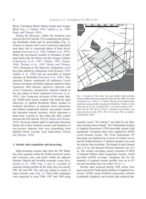
Fig. 3. Location of <strong>the</strong> study area <strong>and</strong> shallow high-resolution<br />
seismic profiles (thin lines) acquired <strong>within</strong> <strong>the</strong> <strong>SW</strong> <strong>Baltic</strong> <strong>Sea</strong> (after<br />
Kramarska et al., 1999). A–AV<strong>and</strong> B–BV-parts of <strong>the</strong> shallow highresolution<br />
seismic profiles crossing <strong>the</strong> Bornholm–Darlowo Fault<br />
Zone shown on Fig. 4, dashed lines—terri<strong>to</strong>rial borders, dots—<br />
wells (A8, K1, K5, K9, L2, Stina-1, Pernille-1 <strong>and</strong> Yoldia-1 are<br />
deep petroleum wells, OT-1, W-3, W-13 <strong>and</strong> 2NE are shallow<br />
car<strong>to</strong>graphic wells).<br />
research vessel ‘‘Dr Lubecki’’ provided by <strong>the</strong> Maritime<br />
Institute from Gdansk. The Ne<strong>the</strong>rl<strong>and</strong>s Institute<br />
of Applied Geoscience (TNO) provided seismic field<br />
equipment. Navigation data were supplied by DGPS<br />
vessel location system. The Texas Instruments 10W<br />
sleevegun was deployed as a source of seismic waves,<br />
<strong>and</strong> <strong>the</strong> Prakla-Seismos 12 channel streamer was used<br />
for seismic data recording. The length of each channel<br />
was 12.4 m, <strong>and</strong> distance between channels was 12.5<br />
m. The seismic recording system consisted of MGS<br />
12-channel Marine Data Acquisition System, which<br />
provided sixfold coverage. Sampling rate for <strong>the</strong><br />
majority of acquired seismic profiles was set <strong>to</strong> 0.5<br />
ms <strong>and</strong> recording time was ei<strong>the</strong>r 0.8 or 1 s.<br />
Seismic data acquired during 1996 cruise were<br />
processed at <strong>the</strong> Ne<strong>the</strong>rl<strong>and</strong>s Institute of Applied Geoscience<br />
(TNO) using ProMAX processing software<br />
(L<strong>and</strong>mark Graphics), <strong>and</strong> seismic data acquired dur-