the field artillery journal - Fort Sill - U.S. Army
the field artillery journal - Fort Sill - U.S. Army
the field artillery journal - Fort Sill - U.S. Army

You also want an ePaper? Increase the reach of your titles
YUMPU automatically turns print PDFs into web optimized ePapers that Google loves.
GERMAN GRID<br />
SYSTEM<br />
The Germans have mapped <strong>the</strong> greater part of Europe, and in<br />
addition have copied maps of o<strong>the</strong>r countries and converted<br />
<strong>the</strong>m to <strong>the</strong>ir own use. German cartography is extremely<br />
painstaking and accurately detailed. Basically, <strong>the</strong> principles of<br />
<strong>the</strong> German grid are similar to <strong>the</strong> U. S. system. Main<br />
differences<br />
are <strong>the</strong> use of <strong>the</strong> metric system and different<br />
methods of determining declination, relief, etc. Knowledge of<br />
<strong>the</strong> system will be of value to personnel having access to<br />
captured documents, situation maps, overlays, etc., in regard to<br />
interpretation, declination, and orientation with <strong>the</strong>ir own maps.<br />
TYPES OF MAPS<br />
Principal military maps used by <strong>the</strong> Wehrmacht are <strong>the</strong> (1)<br />
Deutscher Motorfahrer series, 1:300,000, size 2º × 1º, strategic<br />
road maps covering most of Europe; (2) Reichskarte series,<br />
1:100,000, size 30′ × 15′, hachured federal maps covering greater<br />
Germany; (3) Kartenblatt series, 1:50,000, size 30′ × 15′,<br />
contoured maps of <strong>the</strong> Reich; (4) Messtischblatt series, 1:25,000,<br />
size 10′ × 6′, contoured maps covering most of Germany.<br />
O<strong>the</strong>r types used are 1:1,000,000 strategic (size 6º × 4º)<br />
and<br />
1:10,000 tactical maps. The Germans<br />
also use many French<br />
maps which have been converted to<br />
<strong>the</strong>ir military use.<br />
Marginal information on German maps of tactical scale<br />
usually includes <strong>the</strong> dates of survey, publication, and revision;<br />
<strong>the</strong> name of <strong>the</strong> publishing agency, and <strong>the</strong> index of <strong>the</strong><br />
political boundaries within <strong>the</strong> map,<br />
province, district, etc.; <strong>the</strong><br />
na me and numbers of <strong>the</strong> sheet;<br />
names and numbers of<br />
adjacent sheets, found in <strong>the</strong> borders of <strong>the</strong> map; <strong>the</strong><br />
representative fraction; graphic scales<br />
in meters, kilometers,<br />
and a stride (Schritt) scale ( 80 centimeters, or approximately<br />
32 inches—about one U. S. pace); <strong>the</strong> grid interval in<br />
centimeter s; <strong>the</strong> geographic coordinates<br />
of <strong>the</strong> corners of <strong>the</strong><br />
sheet; a coordinate square of appropriate<br />
scale for <strong>the</strong> map; an<br />
iso gonic diagram plus <strong>the</strong> date<br />
of <strong>the</strong> diagram, information for<br />
<strong>the</strong> annual magnetic change;<br />
a conversion table for degrees to<br />
mils; a mark point and scale<br />
for orienting <strong>the</strong> map; and a<br />
legend of <strong>the</strong> conventional signs and symbols used on <strong>the</strong> map.<br />
SCALE<br />
The representative fraction<br />
is usually 1:25,000, 1:50,000, or<br />
1:100,000. An accurate index to ground distance<br />
is offered by<br />
metric<br />
measurement on maps of <strong>the</strong>se scales: 10 millimeters = 1<br />
centim eter;<br />
100 centimeters = 1,000 millimeters<br />
= 1 meter;<br />
1, 000 meters = 100,000 centimeters = 1,000,000 millimeters = 1<br />
kilometer. Thus: on map RF 1:100,000,<br />
1 cm MD = 1 km GD;<br />
R F 1:50,000, 1 cm MD = ½ km GD ∴ 2 cm MD<br />
= 1 km GD;<br />
R F 1:25,000, 1 cm MD = ¼ cm GD ∴ 4 cm MD<br />
= 1 km GD.<br />
COORDINATES<br />
Modern German maps use <strong>the</strong> same<br />
geographic degree<br />
system as <strong>the</strong> U. S.: latitude is measured<br />
north and south<br />
from <strong>the</strong> equator and longitude<br />
east and west from <strong>the</strong><br />
G reenwich meridian. One degree equals 60 minutes, and<br />
one minute equals 60 seconds. Segments<br />
of one-minute<br />
interval ar e found around <strong>the</strong> borders<br />
of many maps to<br />
facilitate <strong>the</strong> reading of geographic coordinates.<br />
848 FIELD ARTILLERY JOURNAL—December, 1944<br />
By Lt. Samuel<br />
J. Tobin, FA<br />
On some older maps <strong>the</strong> prime meridian is taken from Ferro,<br />
<strong>the</strong> westernmost point or part of <strong>the</strong> Canary Islands. Ferro is<br />
17º 40′ west of Greenwich. In <strong>the</strong> event that any maps happen<br />
to use Berlin as <strong>the</strong> longitudinal origin, <strong>the</strong> German capitol is<br />
13º 21′ 51″ east of Greenwich.<br />
Coordinates are read right and up as in our own system, <strong>the</strong><br />
main difference being <strong>the</strong> use of a comma instead of a decimal<br />
in writing <strong>the</strong> coordinate reference. On maps containing parts<br />
of two adjacent zones, <strong>the</strong> incidence may be determined from<br />
<strong>the</strong> designation of <strong>the</strong> critical grid lines. See Fig. 3.<br />
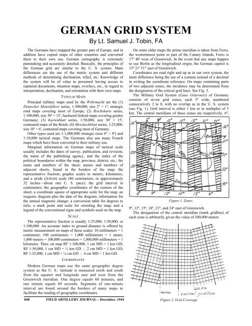
The Military Grid System (Gaus Gitternetz) of Germany<br />
consists of seven grid zones, each 3º wide, numbered<br />
consecutively 2 to 8, with no overlap as in <strong>the</strong> U. S. system<br />
(see Fig. 1). Grid interval is ei<strong>the</strong>r 1 km or in multiples of 5<br />
km. The central meridians of <strong>the</strong>se zones are respectively, 6º,<br />
Figure 1. Zones<br />
9º , 12º, 15º , 18º, 21º, and 24º east of Greenwich.<br />
The designation of <strong>the</strong> central meridian<br />
(mark gridline) of<br />
each zone i s arbitrarily given <strong>the</strong> value of 500,000 meters<br />
Figure<br />
2. Grid Coverage