2023 Fall Issue

Create successful ePaper yourself
Turn your PDF publications into a flip-book with our unique Google optimized e-Paper software.
34<br />
HISTORY<br />
LAKE HOPATCONG NEWS <strong>Fall</strong> <strong>2023</strong><br />
Drawdowns Through<br />
the Years<br />
by MARTY KANE<br />
Photos courtesy<br />
of the<br />
LAKE HOPATCONG<br />
HISTORICAL<br />
MUSEUM<br />
This year heralds a quinquennial event at<br />
Lake Hopatcong—yes, something that<br />
occurs every five years—the 5-foot drawdown of<br />
the lake.<br />
For some, dropping the lake<br />
level is a long-awaited event in<br />
which to attack dock, seawall and<br />
boathouse repairs. For others, it is<br />
an occurrence looked upon with<br />
dread that the lake will not refill<br />
sufficiently by spring.<br />
The drawing down of the lake<br />
after the season has a long history<br />
at Lake Hopatcong going back some<br />
100 years to the abandonment of<br />
the Morris Canal.<br />
Lake Hopatcong is the source or<br />
headwaters of the Musconetcong<br />
River. As such, enough water must<br />
come from the lake to keep<br />
the river flowing.<br />
The natural flow has been<br />
altered and controlled by the<br />
construction of dams at the<br />
southern end of the lake (at<br />
the site of Hopatcong State<br />
Park) commencing in the<br />
1750s. The dam built for the<br />
Morris Canal during the 1820s<br />
and enlarged in 1840 raised<br />
Lake Hopatcong’s water level<br />
to what we know today.<br />
As the largest single source of water for<br />
the canal, Lake Hopatcong had to supply<br />
a significant amount of water to keep<br />
the canal navigable. The water required<br />
for the canal exceeded by several times<br />
the amount needed today to keep the<br />
Musconetcong River flowing.<br />
As Lake Hopatcong began to develop<br />
as a resort in the 1880s, the Morris<br />
Canal became a major issue as residents<br />
and visitors often had to avoid certain<br />
parts of the lake by August due to low<br />
water. Between 1892 and 1912, the lake<br />
averaged some 20 inches below high<br />
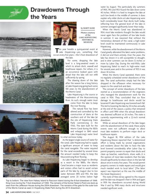
Top to bottom: The view from Halsey Island to Raccoon Island during the 8-foot drawdown of 1948.<br />
King Cove during the 7-foot drawdown of 1959. The remains of the former Nolan’s Point ore dock as<br />
seen from the Jefferson House during the 2004 drawdown. The remains of the gate for the outer lock<br />
of the Morris Canal as seen in Hopatcong State Park during the 2013 drawdown.<br />
water by August. The particularly dry summers<br />
of 1905, 1912 and 1923 found the lake down some<br />
40 inches. While it is hard to imagine the lake at<br />
such low levels in the middle of summer, it does<br />
explain why older docks at Lake Hopatcong were<br />
built considerably lower than docks built today,<br />
reflecting how the general level of the lake in<br />
summer averaged significantly lower than today.<br />
When the Morris Canal was abandoned in<br />
1924, most lake residents thought the lake would<br />
never again face the problem of low lake levels<br />
in summer. It was reasoned that without the<br />
tremendous demand of the canal, a high-water<br />
level could be maintained continuously in Lake<br />
Hopatcong.<br />
However, while the abandonment of the Morris<br />
Canal greatly alleviated the lake’s water problems,<br />
it did not end them entirely. Over the years, the<br />
lake has shown it is still susceptible to drought,<br />
and in drier summers can be down 12 inches or<br />
more by Labor Day. During the mid-1930s, Lake<br />
Hopatcong failed to reach its high-water mark<br />
for several years and in the summer of 1935 it was<br />
down 30 inches.<br />
When the Morris Canal operated, there were<br />
no regularly scheduled winter drawdowns of the<br />
lake. The canal authorities simply had the lake<br />
dropped in the offseason when necessary for<br />
repairs to the canal lock and dam.<br />
The concept of winter drawdowns of the lake<br />
started as a recommendation of the engineers<br />
who managed the abandonment work for the<br />
canal in 1924. They concluded that ice flow<br />
damage to boathouses and docks would be<br />
lessened if Lake Hopatcong was lowered each fall.<br />
This led to lowering the lake by 30 inches annually<br />
at the end of the season, a policy that remained<br />
in effect until 1990 when the annual drawdown<br />
was deemed sufficient at 26 inches. The state is<br />
currently experimenting with a 22-inch normal<br />
drawdown.<br />
While an annual drawdown of the lake began<br />
with the abandonment of the canal, these yearly<br />
events were not sufficient enough to allow<br />
most lake residents to perform major dock or<br />
boathouse repairs.<br />
The August 18, 1934 edition of the Lake<br />
Hopatcong Breeze reported that “a determined<br />
effort is being made by several organizations<br />
and residents about the lake to have the lake<br />
level lowered considerably after Labor Day to<br />
permit property owners to repair their docks and<br />
clean up beaches, waterfronts, shore walls...It is<br />
the opinion of most lake residents that the lake<br />
should significantly be drawn down in the late fall<br />
about once in every five years. This would permit<br />
property owners to make repairs and would give<br />
much needed work to local labor.” [The labor<br />
aspect was important as this was the middle of<br />
the Great Depression.]<br />
The state of New Jersey agreed to this request<br />
and the lake was dropped 5 feet in 1934 and again<br />
in 1939. No drawdowns occurred during World<br />
War II and by 1948 many docks and structures<br />
needed significant work.