Langstrupstien Grøn Mobilitet 2023 - ENGELSK

Create successful ePaper yourself
Turn your PDF publications into a flip-book with our unique Google optimized e-Paper software.
SCAN FOR<br />
MORE INFO<br />
LANGSTRUP PATH - CYCLING FROM<br />
FREDENSBORG TO NIVÅ<br />
Langstrup Path follows trails and country roads from Fredensborg through villages, forests,<br />
and open landscapes to the coastal meadows at the mouth of Nivå River in the Øresund.<br />
From Fredensborg Station, you ride on a fine bike path to Knurreborg Vang and further on the<br />
beautifully winding "Hungarian Ring Road," which was made by Hungarian refugees in the<br />
1950s. The bridge that carries Rolandsvej over Nivå River is one of the country's oldest (about<br />
the year 1600).<br />
Continue cycling through the village of Langstrup and out onto the long straight road along<br />
Langstrup Marsh, an area that was once a shallow fjord extending about four kilometers<br />
inland. At Jellebro, The Langstrup Path goes under the highway. The path now follows Nivå<br />
River out into the peaceful river valley, and where Nivå River flows under Gl. Strandvej, there is<br />
a nice picnic area with tables and benches.<br />
Take a cultural detour and visit Nivaagaard Painting Collection with its impressive collection of<br />
European Baroque, Renaissance, and Danish Golden Age art. Relax in the café with a view of<br />
the large park with thousands of beautiful rhododendrons.<br />
Return to Langstrup Path and to Nivaagaard Brickworks, where the large ring kiln is preserved<br />
as the world's oldest of its kind. The excavation of clay for brick production has shaped the<br />
landscape around Nivå, and the old clay pits have become artificially created lakes surrounded<br />
by a controlled wilderness with a rich birdlife. After the visit, cycle along Gl. Strandvej and turn<br />
right up Nivå Stationsvej to Nivå Station.<br />
FACTS ABOUT THE TOUR<br />
Start: Fredensborg Station<br />
Length 14 km<br />
Surface: Asphalt, gravel<br />
Suitable: Children and adults<br />
Signage: <strong>Langstrupstien</strong><br />
Toilet: Fredensborg Station, Nivå<br />
Station, Nivaagaard<br />
Season: March-November<br />
Find interactive map<br />
through QR-code above<br />
Country Market (1)<br />
Restaurant Skipperhuset (2)<br />
The Nivaagaard Collection (3)<br />
The Nivaagaard Collection (4)<br />
Nivå Ådal (5)<br />
Nivaagaard Brickworks (6)<br />
Hotel Store Kro (7)<br />
Fredensborg Camping (8)<br />
Nivå Camping (9)<br />
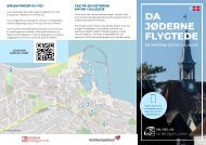
Map on page 2
Tikøb<br />
Gurre<br />
Vang<br />
LANGSTRUPSTIEN<br />
Esrum Sø<br />
Krogenberg<br />
Hegn<br />
Danstrup<br />
Hegn<br />
Endrup<br />
Kvistgård<br />
Kvistgård st.<br />
Espergærde<br />
Langerød<br />
2<br />
7<br />
1<br />
Fredensborg st.<br />
asta<br />
v<br />
j<br />
K nie e<br />
Langerød st.<br />
Fredensborg<br />
Bå<br />
st<br />
ru<br />
p<br />
v<br />
j<br />
e<br />
8<br />
Humlebæk st.<br />
Kratbjerg st.<br />
Asminderød<br />
H<br />
u<br />
l<br />
m<br />
e<br />
bækv<br />
e<br />
j<br />
Humlebæk<br />
Knurrenborg<br />
Vang<br />
Tulstrup Hegn<br />
Rolandsvej<br />
Langstrupvej<br />
Lø<br />
nh ltvej<br />
o<br />
Langstrup Mose<br />
9<br />
<strong>Grøn</strong>holt Hegn<br />
Vejenbrød<br />
Vejenbrødevej<br />
5<br />
Nivå<br />
Nivå st.<br />
Åvej<br />
4<br />
Gammel Strandvej<br />
3<br />
6<br />
Karlebo<br />
Avderød<br />
Kokkedal<br />
Mikkelborg<br />
Store Dyrehave<br />
Kokkedal st.<br />
01 km2 km<br />
3 km 4 km<br />
© OpenStreetMap - © Styrelsen for Dataforsyning og Infrastruktur<br />
Dansk Cykelturisme – Visit Nordsjælland