scarica pdf 859KB - Museo Tridentino di Scienze Naturali
scarica pdf 859KB - Museo Tridentino di Scienze Naturali
scarica pdf 859KB - Museo Tridentino di Scienze Naturali

Create successful ePaper yourself
Turn your PDF publications into a flip-book with our unique Google optimized e-Paper software.
324 Petti et al. Theropod and sauropod footprints from Central Apennines<br />
2. GEOGRAPHICAL AND GEOLOGICAL<br />
SETTING<br />
The Esperia ichnosite is located between the Latina<br />
Valley, to the north, and Gaeta (Tyrrhenian Sea) to the south<br />
(Fig. 1). The stu<strong>di</strong>ed area belongs to the Western Aurunci<br />
Mountains that are part of the Volsci Range (Cosentino et<br />
al. 2002; Centamore et al. 2007). The Volsci structural unit<br />
is constituted by the Lepini, Ausoni and Aurunci Mountains<br />
with the exception of the Eastern Aurunci sector (Simbruini-<br />
Ernici structural unit) and represents the innermost sector of<br />
the ACP, bounded to the west, in the Pontina Plain or in the<br />
Tyrrhenian Sea, by pelagic deposits belonging to the Umbria-Marche-Sabina<br />
Basin, recognized in several wells (ENI<br />
1972; Parotto & Praturlon 1975; Cippitelli 2005). The stratigraphic<br />
sequence of the Aurunci Mountains is mainly composed<br />
of Upper Triassic-Upper Cretaceous carbonate platform<br />
deposits testifying to <strong>di</strong>fferent marine palaeoenvironments<br />
(sabkha, tidal flat, lagoon, open shelf) which are punctuated<br />
by palaeosoils related to depositional environments characterized<br />
by short emersions, mostly in the early Aptian-Cenomanian<br />
time interval (Accor<strong>di</strong> et al. 1967; Chiocchini &<br />
Mancinelli 1977; Carannante et al. 1978; Chiocchini et al.<br />
1994; Rossi et al. 2002; Centamore et al. 2007).<br />
This succession is typical of a carbonate platform environment<br />
where the carbonate deposition keeps pace with<br />
the accommodation space changes (eustasy, subsidence or<br />
uplift and se<strong>di</strong>ment compaction) causing changes from subaerial<br />
to shallow subtidal environment (Carannante et al.<br />
1978; Accor<strong>di</strong> et al. 1988; Chiocchini et al. 1994, Centamore<br />
et al. 2007).<br />
3. THE ESPERIA SECTION: STRATIGRAPHY AND<br />
AGE<br />
The analyzed section, inclu<strong>di</strong>ng the track-bearing surface,<br />
crops out about 3 km to the west of Esperia, along the<br />
road from Esperia to Mt. Acquara <strong>di</strong> Costa Dritta, between<br />
Mt. San Martino to the west and Mt. Lago to the east at<br />
about 410 m a.s.l (41°22′39″N, 13°38′24″E).<br />
The measured section is just over 2.0 metres thick<br />
(Fig. 2) and is cut off by a normal fault at the base of the<br />
sequence. The se<strong>di</strong>mentary succession is composed of well<br />
bedded hazel to light-brown limestone with texture varying<br />
from mudstone to grainstone, sometimes arranged in thicker<br />
layers, which alternate with subor<strong>di</strong>nate oolitic levels<br />
and thin laminated mudstone layers. Locally miliolids and<br />
shell fragments are abundant as well as fenestral structures,<br />
evidences for subaerial exposure. The trampled layer consists<br />
of alternating grainstone and wackestone, with scattered<br />
miliolids and fenestral fabric. Just above the trampled<br />
layer the section is characterized by a conglomerate level (8<br />
cm) with millimiter scale white mudstone clasts. The Esperia<br />
succession exhibits a cyclic facies, alternating from subtidal<br />
to supratidal; sandy facies prevail over muddy ones, suggesting<br />
a shelf environment, exposed to wave and tidal energy<br />
variations.<br />
Analyses on thin sections of collected samples from the<br />
<strong>di</strong>noturbated bed, reveals the occurrence of Dasycladaceans<br />
algae (Salpingoporella spp., ?Thaumatoporella spp.), ru<strong>di</strong>st<br />
fragments and benthic foraminifers, such as abundant Miliolidae,<br />
Nubecularidae (Spiroloculina sp.), Polymorphinidae,<br />
Cuneolinidae (Sabau<strong>di</strong>a briacensis Arnaud-Vanneau 1980,<br />
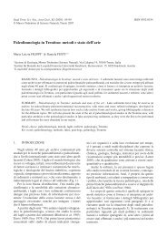
Fig. 1 - Geological and<br />
structural sketch map of<br />
the Central-Southern Apennines.<br />
The tracksite<br />
area is highlighted the<br />
box. From Calamita et<br />
al. 2006, redrawn and<br />
mo<strong>di</strong>fied.<br />
Fig. 1 - Carta geologicostrutturaledell’Appennino<br />
centro-meri<strong>di</strong>onale.<br />
Nel riquadro l’ubicazione<br />
dell’icnosito. Da Calamita<br />
et al. 2006, ri<strong>di</strong>segnato<br />
e mo<strong>di</strong>ficato.