60941 Dalry Walks Outside - North Ayrshire Council
60941 Dalry Walks Outside - North Ayrshire Council
60941 Dalry Walks Outside - North Ayrshire Council

Create successful ePaper yourself
Turn your PDF publications into a flip-book with our unique Google optimized e-Paper software.
Lynn Glen Walk<br />
Distance 2miles / 3.5km<br />
Start from The Cross and go down Main Street<br />
to cross Roche Way into Vennel Street. At the<br />
end turn right, cross a bridge then turn right<br />
again into the road to Saltcoats. Take care<br />
crossing the Lynn Bridge over the Caaf Water<br />
and watch for the start of the path on<br />
your right.<br />
(For a shorter walk there is a car park on the<br />
town side of the Lynn Bridge.) Shortly after the<br />
start of the walk a path dips to the right to<br />
where stepping-stones formerly offered a<br />
crossing. Continue on the south bank of the<br />
Caaf Water to pass a picturesque waterfall<br />
where a lade and the remains of a mill can be<br />
spotted. The glen is the home of birch, hazel<br />
and rowan with the burn attracting wagtails,<br />
dippers and the occasional kingfisher.<br />
At the head of the walk a bridge crosses to<br />
Pinnioch’s Point or Peden’s Pulpit after the<br />
wandering Covenanting preacher who is<br />
said to have delivered sermons from this<br />
commanding rock.<br />
The walk returns on the north side of the glen<br />
passing West Lynn which was the home of<br />
<strong>Dalry</strong>-born artist George Houston (1869 – 1947).<br />
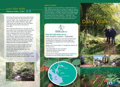
ABOUT DALRY<br />
<strong>Dalry</strong> appears to owe its birth to a market charter of<br />
1681. Seventy years later it is shown on maps as ‘quite a<br />
substantial place irregularly developed between the Rye<br />
and Caaf Waters’. By 1800 it housed around 800 people<br />
mainly employed in silk and cotton manufacture. With<br />
the railway came heavy industry – ironworks, coal<br />
mining, brickworks and limeworks. The relics of these<br />
industries can still be seen in and around the town.<br />
Know the Code before you go ...<br />
Enjoy Scotland’s outdoors - responsibly!<br />
Everyone has the right to be on most land and inland water<br />
providing they act responsibly. Your access rights and<br />
responsibilities are explained fully in the Scottish Outdoor<br />
Access Code.<br />
Whether you’re in the outdoors or managing the outdoors, the<br />
key things are to:<br />
• take responsibility for your own actions<br />
• respect the interests of other people<br />
• care for the environment.<br />
Find out more by visiting www.outdooraccess-scotland.com<br />
or phoning your local Scottish Natural Heritage office.<br />
Bute<br />
Arran Firth<br />
of<br />
Clyde<br />
Greenock<br />
Largs<br />
<strong>Dalry</strong><br />
Irvine<br />
Ayr<br />
Glasgow<br />
Kilmarnock<br />
<strong>Dalry</strong> <strong>Walks</strong><br />
www.ayrshirepaths.org.uk
(An alternative is to turn left over Flashwood<br />
Bridge and return via the Doggartland Walk by<br />
going through the gate at the old limekiln.<br />
You will be doing this walk in reverse but it is a<br />
straight forward descent to the main Kilbirnie<br />
road where you turn right to continue to The<br />
Cross. This will give you a walk of about 4<br />
miles.)<br />
The Velvet Path gained its name when it was a<br />
green, grass-carpeted track. This pleasant lane<br />
through old hedgerows rises slowly to meet a<br />
road after about half a mile. Turn right and<br />
pass Baidland Mill before the junction where<br />
you turn right and keep right to eventually<br />
pass Flashwood farm where you join the return<br />
route from the Doggartland Walk. Shortly you<br />
pass the entrance to the Velvet Path and retrace<br />
the route back to <strong>Dalry</strong>.<br />
This is a short walk which sets out on the same<br />
route as the Baidlandhill Walk – follow as<br />
detailed. Shortly before you turn left onto the<br />
track you may spot the remains of an old<br />
bridge over to Broadlie House which sits up<br />
amongst the trees. There are one or two little<br />
waterfalls on the Putyan Burn close by.<br />
The Velvet Path Walk<br />
Distance 2.75 miles / 4.5 km<br />
As all the walks have sections on working<br />
farmland you should be prepared for<br />
muddy lengths if the weather has been wet.<br />
Stout footwear is recommended.<br />
Please Note<br />
The path, known locally as the Doggartland,<br />
continues to rejoin the public road just before<br />
Flashwood Farm. Note the old limekiln on your<br />
right just at the gate. It is a memorial to a dead<br />
industry once important in this area. Cross<br />
Flashwood Bridge, turn left and follow the<br />
Putyan Burn with little waterfalls downhill back<br />
to <strong>Dalry</strong>.<br />
From The Cross continue into <strong>North</strong> Street<br />
bearing right at the main junction into the road<br />
to Kilbirnie. Continue for about half a mile and<br />
turn left immediately past Johnstone Castings.<br />
(Do not cross the Rye Water bridge.) Very soon<br />
this becomes a pleasant woodland path which<br />
soon climbs to leave the burn. Keep right at a<br />
fork in the path.<br />
The Doggartland Walk<br />
Distance 2.5 miles / 4 km<br />
Follow the track into a conifer forest and out<br />
of it again to the remote homestead of<br />
Wardlaw. Continue the descent turning left on<br />
the public road to pass Auldmuir and Baidland<br />
Mains before re-entering the Velvet Path to<br />
retrace your route to <strong>Dalry</strong>. (Alternatively you<br />
can return by the second part of the Velvet<br />
Path Walk)<br />
The views are panoramic, particularly into the<br />
Firth of Clyde. A short detour up to the masts<br />
gives an even grander outlook.<br />
Leave The Cross via <strong>North</strong> Street and cross<br />
Roche Way into James Street. At the end go<br />
right into West Kilbride Road to turn right<br />
into Wingfaulds Road at the end of the<br />
cemetery. This shortly becomes a pleasant<br />
country road and after about half a mile bear<br />
left at a gate into a lane which is known<br />
locally as the Velvet Path. Continue until you<br />
meet the public road and turn right to pass<br />
Baidland Mill. At the T-junction turn left and<br />
steadily rise for over a mile to climb the stiles<br />
just before Baidlandhill Farm.<br />
Start from the historic centre of <strong>Dalry</strong> at The<br />
Cross where the 50m spire of St Margaret’s<br />
Church dominates the scene. Other buildings<br />
include the crow-stepped bank, the library in<br />
the former town hall and the Trinity Church.<br />
Most date from the 1850s. The granite Biggart<br />
Fountain is also worth noting.<br />
Baidlandhill Walk<br />
Distance 7.5 miles / 12 km
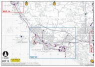
Knockendon<br />
Reservoir<br />
Wardlaw<br />
To<br />
Fairlie<br />
Baidlandhill Knock Hill Walk<br />
Greeto Velvet Path Bridge Walk Walk<br />
The Lynn Pencil Glen Walk<br />
Douglas Doggartland Park Walk<br />
Caaf<br />
Resevoir<br />
Gill Hill<br />
Blackstone<br />
Baidland<br />
Hill<br />
Ward Farm<br />
Little Auldmuir<br />
Third Part<br />
Auldmuir<br />
Reservoir<br />
Auldmuir<br />
The walks in this leaflet are supported by<br />
<strong>Dalry</strong><br />
Community<br />
<strong>Council</strong><br />
BaidlandHill<br />
Windyedge<br />
Baidland<br />
Mains<br />
To<br />
Ardrossan<br />
Cubeside<br />
Laigh<br />
Baidland<br />
Giffordland<br />
Leaflet designed and written by Drew Moyes.<br />
Printed by Kestrel Press<br />
Flashwood<br />
Mosside<br />
Holms<br />
of Caaf<br />
Caaf Water<br />
Rye<br />
Water<br />
Burntongues<br />
Meikle<br />
Broadlie<br />
Broadlie<br />
House<br />
Mount<br />
Pleasant<br />
Lynn<br />
Glen<br />
More detailed information can be obtained<br />
from the following maps:<br />
OS LANDRANGER No 63 Scale 1 : 50 000<br />
OS EXPLORER No 341 Scale 1 : 25 000<br />
Dykes<br />
Gowanlea<br />
Meiklemyre<br />
Hindog<br />
High<br />
Lynn<br />
To<br />
Saltcoats<br />
Ryefield<br />
House<br />
Cemetery<br />
Craighead<br />
Doggartland<br />
Parking<br />
To<br />
Kilwinning<br />
To<br />
Kilbirnie<br />
Parking<br />
The Cross<br />
<strong>Dalry</strong><br />
Station<br />
Hillend<br />
Blairland<br />
River Garnock<br />
Stoopshill<br />
James Street<br />
Sharon Street<br />
Blair<br />
Vennel Street Main<br />
Blair<br />
Park<br />
Way<br />
Roche<br />
Street<br />
<strong>North</strong><br />
Street<br />
The<br />
Cross<br />
<strong>Dalry</strong><br />
Town<br />
Centre<br />
P<br />
Walk<br />
Info<br />
Board<br />
Blair <strong>Walks</strong><br />
Library<br />
Walkers are also welcome<br />
to enjoy a number of<br />
paths in Blair Estate.