PEREGRINATIONS IN ASIA MINOR - University of Melbourne
PEREGRINATIONS IN ASIA MINOR - University of Melbourne
PEREGRINATIONS IN ASIA MINOR - University of Melbourne

You also want an ePaper? Increase the reach of your titles
YUMPU automatically turns print PDFs into web optimized ePapers that Google loves.
<strong>PEREGR<strong>IN</strong>ATIONS</strong><br />
<strong>IN</strong> <strong>ASIA</strong> M<strong>IN</strong>OR<br />
European description and cartography<br />
in the 16th and 17th centuries<br />
A Baillieu Library Exhibition
A Baillieu Library Exhibition<br />
7 February to 1 April 2005<br />
<strong>University</strong> Library Exhibition Space<br />
1st Floor<br />
Baillieu Library<br />
<strong>University</strong> <strong>of</strong> <strong>Melbourne</strong><br />
I T E M 2 5
<strong>PEREGR<strong>IN</strong>ATIONS</strong> <strong>IN</strong> <strong>ASIA</strong> M<strong>IN</strong>OR<br />
European description and cartography in the 16th and 17th centuries<br />
Curators: David Jones and Julianne Simpson<br />
An exhibition <strong>of</strong> items from the<br />
<strong>University</strong> <strong>of</strong> <strong>Melbourne</strong> Library’s Ronald and Pamela Walker Collection<br />
<strong>of</strong> maps <strong>of</strong> Asia Minor, and the Special Collections
Published by the <strong>University</strong> <strong>of</strong> <strong>Melbourne</strong> Library<br />
<strong>University</strong> <strong>of</strong> <strong>Melbourne</strong><br />
Victoria 3010<br />
ISBN 0 7340 3058 4<br />
© <strong>University</strong> <strong>of</strong> <strong>Melbourne</strong>, <strong>University</strong> Library 2005<br />
Text and exhibition design: David Jones and Julianne Simpson<br />
Catalogue designer: Jacqui Barnett<br />
Editor: Susan Reidy<br />
Production: Information Division Communications and Publications Unit, <strong>University</strong> <strong>of</strong> <strong>Melbourne</strong>
<strong>PEREGR<strong>IN</strong>ATIONS</strong> <strong>IN</strong> <strong>ASIA</strong> M<strong>IN</strong>OR<br />
European description and cartography in the 16th and 17th centuries<br />
I N T R O D U C T I O N<br />
This exhibition has been mounted in conjunction with the Australian Map Circle conference in<br />
February 2005. It includes items from the Map Collection and Special Collections at the<br />
<strong>University</strong> <strong>of</strong> <strong>Melbourne</strong> Library. The sheet maps in this exhibition are exclusively drawn from<br />
the Ronald and Pamela Walker Collection <strong>of</strong> maps <strong>of</strong> Asia Minor, donated to the <strong>University</strong> by Ronald<br />
and Pamela Walker in 1991. Of great significance in the collection are works by the most important<br />
figures in the development <strong>of</strong> cartography, in particular Claudius Ptolemy, Abraham Ortelius and<br />
Gerhard Mercator. The exhibition also contains several modern supporting items with reproductions <strong>of</strong><br />
historical materials.<br />
Ronald and Pamela Walker formed their collection during the 1970s and 1980s after Ronald was<br />
posted as an Australian diplomat to Ankara, the capital <strong>of</strong> Turkey. They greatly enjoyed their time in<br />
Turkey, were fascinated by its history and developed a strong affection for that country and its people.<br />
Their shared interest in the earlier map makers and Asia Minor prompted them to begin collecting<br />
cartographic works by Ptolemy and all the early European cartographers. The theme <strong>of</strong> the collection<br />
was “Printed maps <strong>of</strong> Turkey before 1700 AD”, and was to be encyclopaedic and track (via examples) the<br />
evolution <strong>of</strong> European map making from the late 15th century to the end <strong>of</strong> the 17th century. They<br />
started collecting shortly after leaving Turkey for Canberra in 1971, purchasing mainly by<br />
correspondence from British and American dealers and from the London auction houses. However, the<br />
most productive hunting came when Ron was posted to Paris in 1972 and 1973. During the 1970s maps<br />
<strong>of</strong> Turkey were relatively inexpensive as they were not in great demand.<br />
By the mid-1980s the Walkers had built a comprehensive collection with only a few gaps. However,<br />
at that stage the time that elapsed between opportunities to add to their collection and the high cost <strong>of</strong><br />
the scarcest maps took much <strong>of</strong> the fun out <strong>of</strong> collecting. So, the Walkers decided to stop collecting and<br />
donate the bulk <strong>of</strong> their collection to an Australian public institution. They chose the <strong>University</strong> <strong>of</strong><br />
<strong>Melbourne</strong> as the most appropriate recipient. The only portions <strong>of</strong> the original collection not donated<br />
were the maps covering the whole Turkish Empire, which were sold, and the plans and bird’s eye views<br />
<strong>of</strong> Istanbul, which the Walkers kept.<br />
The Walker Collection has recently been digitised, and is now available online with many other<br />
significant cartographic works <strong>of</strong> <strong>Melbourne</strong>, Victoria and Australia. Access to these images is from the<br />
Map Collection website, .<br />
David Jones<br />
Acting Map Curator, <strong>University</strong> <strong>of</strong> <strong>Melbourne</strong> Library<br />
<strong>PEREGR<strong>IN</strong>ATIONS</strong> <strong>IN</strong> <strong>ASIA</strong> M<strong>IN</strong>OR 3
I T E M 16<br />
4 <strong>PEREGR<strong>IN</strong>ATIONS</strong> <strong>IN</strong> <strong>ASIA</strong> M<strong>IN</strong>OR
1. Ptolemy, 2nd century, Cosmographia. New<br />
York, Harcourt Brace Jovanovich, 1983.<br />
Facsimile <strong>of</strong> Vatican Library manuscript, Urb.<br />
Lat. 277. (Codices e vaticanis selecti, no. LIII)<br />
Claudius Ptolemy was a Greek geographer,<br />
mathematician and astronomer who lived in the<br />
2nd century A.D. The oldest known manuscript<br />
copy <strong>of</strong> the Cosmographia (or Geographia) is from<br />
around 1300. Ptolemy provided a basic<br />
description <strong>of</strong> the Earth and <strong>of</strong> cartography at<br />
that time, and gave a guide to preparing a map.<br />
He also developed the concept <strong>of</strong> four systems <strong>of</strong><br />
map projection and a table <strong>of</strong> coordinates<br />
(leading to the current expression <strong>of</strong> latitude and<br />
longitude). He summarised the knowledge <strong>of</strong> the<br />
physical features <strong>of</strong> the Earth at that time, and<br />
knew that the Earth was not flat, but a sphere.<br />
The copy on display is a facsimile <strong>of</strong> a<br />
magnificent manuscript produced at Florence in<br />
1472 for Federigo de Montefeltro, Duke <strong>of</strong><br />
Urbino.<br />
2. Ambrosius Aurelius Theodosius Macrobius,<br />
Commentarii in Somnium Scipionis. Saturnalia,<br />
Brescia, Boninis de Boninis, 15 May 1485.<br />
Woodcut map <strong>of</strong> the world on folio F5a.<br />
3. Faut von Sezgin, Geschichte des Arabischen<br />
Schrifttums. Band XII, Frankfurt am Main,<br />
2000.<br />
This volume contains illustrations <strong>of</strong> maps and<br />
diagrams mentioned and supporting the views <strong>of</strong><br />
the author in the preceding volumes I–XI.<br />
The maps from different culture areas serve to<br />
support the conviction <strong>of</strong> the process <strong>of</strong> the<br />
historical connection.<br />
L A R G E M I D D L E C A B I N E T O N E<br />
4. Nicolas de Nicolay, 1517–1583, Les<br />
Navigations Peregrinations et Voyages, Faicts en la<br />
Turquie, par Nicolas de Nicolay Daulphinoys,<br />
Seigneur d’Arfeville ... contenants plusieurs<br />
singularitez que l’autheur y a veu & obserué. Le<br />
tout distingué en quatre liures. Auec soixante<br />
figures au naturel tant d’hommes, que de femmes<br />
selon la diuersité des nations, leur port, maintien,<br />
habits, loyx, religion & façon de viure, tant en<br />
temps de paix comme de guerre. Auec plusieurs<br />
belles & memorables histoires, advenuës en nostre<br />
temps. Antwerp, Willem Silvius, 1576.<br />
Nicolay was the royal geographer <strong>of</strong> France<br />
during the reign <strong>of</strong> Henry II. He was part <strong>of</strong> an<br />
embassy to Constantinople in 1551 and his<br />
reports <strong>of</strong> scenes and customs are an important<br />
source <strong>of</strong> 16th century Europe’s knowledge <strong>of</strong> the<br />
Near East.<br />
5. William Lithgow, 1582?–1645, The Totall<br />
Discourse, <strong>of</strong> the Rare Aduentures, and Painefull<br />
Peregrinations <strong>of</strong> Long Nineteene Yeares Trauayles,<br />
from Scotland, to the Most Famous Kingdomes in<br />
Europe, Asia and Affrica. Perfited by three deare<br />
bought voyages, in surveighing <strong>of</strong> forty eight<br />
Kingdomes ancient and moderne; twenty one Reipublickes,<br />
ten absolute principalities, with two<br />
hundred Ilands. The particular names where<strong>of</strong>, are<br />
described in each argument <strong>of</strong> the ten diuisions <strong>of</strong><br />
this History: And it also diuided in three bookes;<br />
two where<strong>of</strong>, neuer heret<strong>of</strong>ore published. Wherein<br />
is contayned, an exact relation, <strong>of</strong> the lawes,<br />
religion, policies, and gouernment <strong>of</strong> all their<br />
princes, potentates, and people. Together with the<br />
grievous tortures he suffered, by the Inquisition <strong>of</strong><br />
<strong>PEREGR<strong>IN</strong>ATIONS</strong> <strong>IN</strong> <strong>ASIA</strong> M<strong>IN</strong>OR 5
Malaga in Spaine, his miraculous discovery and<br />
deliuery thence: And <strong>of</strong> his last and late returne<br />
from the Northerne Iles. … By William Lithgow.<br />
London, Nicholas Okes, 1632.<br />
6. George Sandys, 1578–1644, Sandys Travailes:<br />
containing a history <strong>of</strong> the originall and present<br />
state <strong>of</strong> the Turkish empire: their lawes,<br />
governement, policy, military force, courts <strong>of</strong> justice,<br />
and commerce: the Mahometan religion and<br />
ceremonies. A description <strong>of</strong> Constantinople, the<br />
Grand Signiors Seraglio, and his manner <strong>of</strong> living:<br />
also, <strong>of</strong> Greece, with the religion and customes <strong>of</strong> the<br />
Græcians. Of Ægypt; the antiquity, hieroglyphicks,<br />
rites, customes, discipline, and religion <strong>of</strong> the<br />
Ægyptians: a voyage on the river Nilus: <strong>of</strong><br />
Armenia, Grand Cairo, Rhodes, the Pyramides,<br />
Colossus; the former flourishing and present state <strong>of</strong><br />
Alexandria. A description <strong>of</strong> the holy-land; <strong>of</strong> the<br />
Jews and severall sects <strong>of</strong> Christians living there; <strong>of</strong><br />
Jerusalem, sepulchre <strong>of</strong> Christ, temple <strong>of</strong> Solomon;<br />
and what else either <strong>of</strong> antiquity, or worth<br />
observation. Lastly, Italy described, and the islands<br />
adjoyning; as Cyprus, Crete, Malta, Sicilia, the<br />
Æolian islands; <strong>of</strong> Rome, Venice, Naples, Syracusa,<br />
Mesena, Ætna, Scylla and Charybdis; and other<br />
places <strong>of</strong> note. Illustrated with fifty graven maps<br />
and figures. Fifth edition. London, Richard<br />
Cotes, 1652.<br />
7. Petrus Bertius, 1565–1629, Natolie (map).<br />
Scale not given, colour, 81 x 121 mm, 1616.<br />
Likely to be from an edition <strong>of</strong> his small atlas,<br />
Tabularum Geographicarum Contractarm … libri tre<br />
(1600). Bertius was cosmographer to the French<br />
king Louis XIII from 1618. He was the brother-inlaw<br />
<strong>of</strong> both Jodocus Hondudius and Pieter van<br />
den Keere, with whom he collaborated.<br />
8. Gerhard Mercator, 1512–1594, Natolie<br />
(map). Scale (ca. 1:1,000,000), colour, 14 x 18<br />
cm, 1614.<br />
Gerhard Mercator was the most famous<br />
cartographer after Ptolemy. He was born in<br />
Rupelmonde, Flanders and died in Duisburg,<br />
Germany. He invented the Mercator projection<br />
and coined the name ‘atlas’ for a collection <strong>of</strong><br />
maps. He had a great sense <strong>of</strong> exact scientific<br />
work and drew new maps in original conception,<br />
rather than copying the work <strong>of</strong> others.<br />
9. Gerhard Mercator, 1512–1594, Natolia, quae<br />
olim Asia minor (map). Scale (ca. 1:794,000),<br />
colour, 14 x 18 cm, 1651.<br />
10. Abraham Ortelius, 1527–1598, Natolie<br />
(map). Scale not given, colour, 14 x 18 cm,<br />
1598?<br />
Abraham Ortelius was, after Mercator, the most<br />
famous cartographer <strong>of</strong> the 16th century. He was<br />
born and died in Amsterdam in the Netherlands.<br />
In 1570 he wrote and published the first uniform<br />
atlas, Theatrum Orbis Terrarum.<br />
6 <strong>PEREGR<strong>IN</strong>ATIONS</strong> <strong>IN</strong> <strong>ASIA</strong> M<strong>IN</strong>OR
I T E M 3 0<br />
<strong>PEREGR<strong>IN</strong>ATIONS</strong> <strong>IN</strong> <strong>ASIA</strong> M<strong>IN</strong>OR 7
I T E M 19<br />
8 <strong>PEREGR<strong>IN</strong>ATIONS</strong> <strong>IN</strong> <strong>ASIA</strong> M<strong>IN</strong>OR
<strong>PEREGR<strong>IN</strong>ATIONS</strong> <strong>IN</strong> <strong>ASIA</strong> M<strong>IN</strong>OR 9
I T E M 2 2<br />
10 <strong>PEREGR<strong>IN</strong>ATIONS</strong> <strong>IN</strong> <strong>ASIA</strong> M<strong>IN</strong>OR
11. Richard Knolles, 1550?–1610, The Generall<br />
Historie <strong>of</strong> the Turkes, from the First Beginning <strong>of</strong><br />
that Nation to the Rising <strong>of</strong> the Othoman Familie.<br />
With all the notable expeditions <strong>of</strong> the Christian<br />
princes against them. Together with the liues and<br />
conquests <strong>of</strong> the Othoman kings and emperours<br />
faithfullie collected out <strong>of</strong> the- best histories, both<br />
auntient and moderne, and digested into one<br />
continuat historie vntill this present yeare 1603: by<br />
Richard Knolles. London, Adam Islip, 1603.<br />
12. Joseph Pitton de Tournefort, 1656–1708, A<br />
Voyage into the Levant: perform’d by command <strong>of</strong><br />
the late French King. Containing the antient and<br />
modern state <strong>of</strong> the islands <strong>of</strong> the Archipelago; as<br />
also <strong>of</strong> Constantinople, the coasts <strong>of</strong> the Black Sea,<br />
Armenia, Georgia, the frontiers <strong>of</strong> Persia, and Asia<br />
Minor. With plans <strong>of</strong> the principal towns and<br />
places <strong>of</strong> note ... By M. Tournefort ... ; To which is<br />
prefix’d, the author’s life, in a letter to M. Begon: as<br />
also his elogium, pronounc’d by M. Fontenelle ...<br />
London, printed for D. Browne, A. Bell,<br />
J. Darby, A. Bettesworth, J. Pemberton,<br />
C. Rivington, J. Hooke, R. Cruttenden and<br />
T. Cox, J. Battley, E. Symon, 1718.<br />
13. Pierre Gilles, 1490–1555, The Antiquities <strong>of</strong><br />
Constantinople. With a description <strong>of</strong> its situation,<br />
the conveniencies <strong>of</strong> its port, its publick buildings;<br />
the statuary, sculpture, architecture, and other<br />
curiosities <strong>of</strong> that city. With cuts explaining the<br />
chief <strong>of</strong> them. In four books. Written originally in<br />
Latin by Petrus Gyllius ... Now translated into<br />
English, and enlarged with an ancient description<br />
<strong>of</strong> the wards <strong>of</strong> that city, ... by John Ball, ...<br />
London, printed for the benefit <strong>of</strong> the<br />
translator, 1729.<br />
L A R G E M I D D L E C A B I N E T T W O<br />
14. Fynes Moryson, 1566–1630, An Itinerary<br />
Vvritten by Fynes Moryson Gent. First in the<br />
Latine tongue, and then translated by him into<br />
English: containing his ten yeeres trauell through<br />
the tvvelue dominions <strong>of</strong> Germany, Bohmerland,<br />
Sweitzerland, Netherland, Denmarke, Poland,<br />
Jtaly, Turky, France, England, Scotland, and<br />
Ireland. Diuided into III parts. The I. part.<br />
Containeth a iournall through all the said twelue<br />
dominions: shewing particularly the number <strong>of</strong><br />
miles, the soyle <strong>of</strong> the country, the situation <strong>of</strong> cities,<br />
the descriptions <strong>of</strong> them, with all monuments in<br />
each place worth the seeing, as also the rates <strong>of</strong><br />
hiring coaches or horses from place to place, with<br />
each daies expences for diet, horse-meate, and the<br />
like. The II. part. Containeth the rebellion <strong>of</strong> Hugh,<br />
Earle <strong>of</strong> Tyrone, and the appeasing there<strong>of</strong>: written<br />
also in forme <strong>of</strong> a iournall. The III. part.<br />
Containeth a discourse vpon seuerall heads,<br />
through all the said seuerall dominions. London,<br />
John Beale, 1617.<br />
15. Pierre Duval, 1619–1682, L’empire des Tvrcs<br />
(map). Scale not given, colour, 9 x 11 cm, 1672.<br />
Duval was the nephew and pupil <strong>of</strong> Nicolas<br />
Sanson.<br />
16. Allain Manesson-Mallet, 1630?–1706?,<br />
Natolie (map). Scale not given, colour, 13 x 9<br />
cm, 1683.<br />
17. Robert Morden, The Turkish Empire in Asia<br />
(map). Scale not given. colour, 11 x 13 cm, on<br />
sheet 20 x 16 cm, 1688.<br />
18. John Seller, fl. 1658–1698, Turky in Asia<br />
(map). Scale not given, colour, 11 x 13 cm,<br />
1690.<br />
<strong>PEREGR<strong>IN</strong>ATIONS</strong> <strong>IN</strong> <strong>ASIA</strong> M<strong>IN</strong>OR 11
19. Henri Abraham Chatelain, Carte de l’empire<br />
des Turcs en Europe et Asie (map). Scale not<br />
given, 10 x 18 cm on sheet 45 x 97 cm. Extract<br />
from: Atlas Historique, ou, Nouvelle Introduction<br />
a l’histoire, a la Chronologie & a la Geographie<br />
Ancienne et Moderne ... par Mr. C. A Amsterdam,<br />
Chez les freres Chatelain libraries, 1714.<br />
This map is an inset on Carte Genealogique de la<br />
Suite des Empereurs d’orient de Trebisonde,<br />
d’Andrinople et Ottomans ...<br />
20. Anonymous, (Map <strong>of</strong> Turkey) (map). Scale<br />
(c. 1:903,000), colour, 45 x 69 cm, 17—?<br />
WA L L C A B I N E T<br />
21. The Maps and Text <strong>of</strong> the Boke <strong>of</strong> Idrography<br />
Presented by Jean Rotz to Henry VIII, Now in the<br />
British Library, Edited by Helen Wallis, with a<br />
Foreword by Viscount Eccles. Oxford, printed for<br />
presentation to the members <strong>of</strong> the Roxburghe<br />
Club, 1981.<br />
This is a facsimile <strong>of</strong> a collection <strong>of</strong> maps<br />
presented to Henry VIII by Jean Rotz, who was<br />
seeking employment with the English king. Rotz<br />
was subsequently appointed as the royal<br />
hydrographer.<br />
T A L L S T A N D I N G C A B I N E T O N E<br />
22. William Hole, d.1646, (The Near East)<br />
(map). Scale not given, 31 x 39 cm, 1614?<br />
William Hole was an English engraver <strong>of</strong> maps,<br />
portraits, music, title pages and illustrations. He<br />
also produced a general map <strong>of</strong> England and<br />
Wales, and English and Welsh county maps (after<br />
Christopher Saxton) for George Bishop and John<br />
Norton’s edition <strong>of</strong> William Camden’s Britannia,<br />
1607 (with William Kip). This map is from<br />
Walter Raleigh’s History <strong>of</strong> the World (1614), also<br />
on display in this case.<br />
23. Sir Walter Raleigh, 1552–1618, The History<br />
<strong>of</strong> the World. London, Walter Burre, 1614.<br />
T A L L S T A N D I N G C A B I N E T T W O<br />
24. Vincenzo Coronelli, 1650–1718, (Globe Gore<br />
Showing Black Sea South to Indian Ocean) (map).<br />
Scale not given, colour, 46 x 28 cm, (Venice?),<br />
1680?<br />
Vincenzo Maria Coronelli was cosmographer to<br />
the Republic <strong>of</strong> Venice from 1685, a globe maker,<br />
and also a Franciscan friar and general <strong>of</strong> the<br />
Order from 1701. In 1680 he founded the first<br />
geographical society, the Academia Cosmografica<br />
degli Argonauti. This map is probably from the<br />
Corso Geografico Universale.<br />
S I N G L E C A B I N E T S<br />
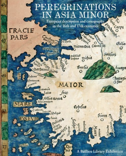
25. Martin Waldseemüller, 1470–1521? (after<br />
Ptolemy) Tabvla Nova Asia Minoris (map).<br />
Scale (c. 1:3,700,000), 34 x 47 cm, 1513.<br />
A hand coloured map <strong>of</strong> Turkey by Martin<br />
Waldseemüller from the 1513 Strasbourg edition<br />
<strong>of</strong> Ptolemy’s Geographia published by Johann<br />
Schott.<br />
26. Ptolemy, 2nd century, Prima Asiae Tabvla<br />
(map). Scale (c. 1:3,250,000), colour, 36 x 50<br />
cm, (1513?).<br />
This map is probably from the 1513 edition<br />
published in Strasbourg. This was the first<br />
printed atlas in two colours.<br />
12 <strong>PEREGR<strong>IN</strong>ATIONS</strong> <strong>IN</strong> <strong>ASIA</strong> M<strong>IN</strong>OR
I T E M 2 9<br />
<strong>PEREGR<strong>IN</strong>ATIONS</strong> <strong>IN</strong> <strong>ASIA</strong> M<strong>IN</strong>OR 13
I T E M 18<br />
14 <strong>PEREGR<strong>IN</strong>ATIONS</strong> <strong>IN</strong> <strong>ASIA</strong> M<strong>IN</strong>OR
27. Gerard de Jode, 1509–1591, Natoliam<br />
Modern, Dicunt eam Partem Quam Asiam<br />
Minorem Appellavere Veteres (map). Scale not<br />
given, 38 x 51 cm, 1578.<br />
Gerard de Jode was an engraver, printer, printseller,<br />
publisher and cartographer. He was born at<br />
Nijmegen in the Netherlands and died in<br />
Amsterdam. This map is probably from the<br />
Speculum Orbis Terrarum.<br />
28. Richard Blome, d. 1705, A Mapp <strong>of</strong> the<br />
Estates <strong>of</strong> the Turkish Empire in Asia, and Europe<br />
(map). Scale (c. 1:4,000,000), colour, 25 x 40<br />
cm, 1669.<br />
Blome was a London map and bookseller and<br />
freeman <strong>of</strong> the Company <strong>of</strong> Stationers (1660).<br />
His principal work was Britannia (an atlas <strong>of</strong><br />
country maps based on Speed).<br />
29. Abraham Ortelius, 1527–1598, Alexandri<br />
Magni Macedonis Expeditio (map). Scale<br />
(c. 1:13,000,000), 35 x 50 cm, (Antwerp?),<br />
1595.<br />
30. Hendrick Doncker, 1626–1699, Smyrne en<br />
de Eylanden Scio en Metelino (map). Scale<br />
(c. 1:300,000), 40 x 51 cm, Amsterdam, By<br />
Hendrick Doncker ..., 1664?<br />
31. Guillaume Sanson, d.1703, Paphlagonia<br />
(map): heroicis temporibus, henetorum populorum<br />
R E F E R E N C E S<br />
sede clara, cujus Paphlagonia maritima suit<br />
Romanorum aetate Ponti Regni pars occidentalior<br />
... Gulielmi Sanson Nicolai filii. Scale (c.<br />
1:870,000), 37 x 49 cm, Lutetiae Parisiorum<br />
(Paris), apud Petrum Mariette, 167–?<br />
Nicolas Sanson has been called the father <strong>of</strong> the<br />
French School <strong>of</strong> Geography and was a tutor to<br />
Louis XIV. His sons, Guillaume and Adrian,<br />
continued their father’s business in Paris.<br />
32. Guillaume Sanson, d.1703, Pamphilia et<br />
Pisidia (map): conatibus geographicis Gulielmi<br />
Sanson Nicolai filij. Scale (c. 1:870,000), colour,<br />
32 x 50 cm, (Paris), Apud Petrum Mariette ...,<br />
1670.<br />
33. Guillaume Sanson, d.1703, Anaplus<br />
Bosphori Thracii (map) ex indagationibus Petri<br />
Gyllii ; delineatus à Gulielmo Sanson Nic filio ...<br />
Scale not given, colour, 39 x 52 cm, (Paris),<br />
Apud Petrum Mariette ... 1666.<br />
34. Pieter van der Aa, 1659–1733, Turquie en<br />
Europe (map): suivant les nouvelles observations<br />
de Messrs de l’Academie royale des sciences etc.<br />
Augmentees de nouveau. Scale (c. 1:3,831,000),<br />
21 x 29 cm, A Leide, Chez Pierre vander<br />
Aa ... 1729?<br />
• Leo Bagrow, History <strong>of</strong> Cartography, 1966<br />
• Robert Karrow, Mapmakers <strong>of</strong> the Sixteenth Century and Their Maps, 1993<br />
• The National Geographic Desk Reference, 1999<br />
• R. V. Tooley, Tooley’s Dictionary <strong>of</strong> Mapmakers, 1979; and revised edition A–D, 1999 and revised edition E–J, 2001<br />
<strong>PEREGR<strong>IN</strong>ATIONS</strong> <strong>IN</strong> <strong>ASIA</strong> M<strong>IN</strong>OR 15
I T E M 2 4<br />
16 <strong>PEREGR<strong>IN</strong>ATIONS</strong> <strong>IN</strong> <strong>ASIA</strong> M<strong>IN</strong>OR
I T E M 8