Health Systems in Transition: Georgia - World Health Organization ...
Health Systems in Transition: Georgia - World Health Organization ...
Health Systems in Transition: Georgia - World Health Organization ...
- TAGS
- georgia
- www.euro.who.int

You also want an ePaper? Increase the reach of your titles
YUMPU automatically turns print PDFs into web optimized ePapers that Google loves.
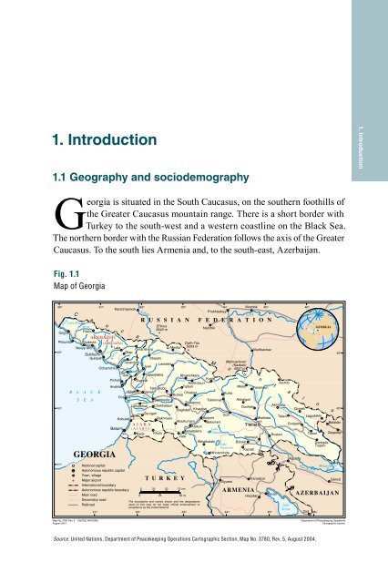
1. Introduction<br />
1.1 Geography and sociodemography<br />
<strong>Georgia</strong> is situated <strong>in</strong> the South Caucasus, on the southern foothills of<br />
the Greater Caucasus mounta<strong>in</strong> range. There is a short border with<br />
Turkey to the south-west and a western coastl<strong>in</strong>e on the Black Sea.<br />
The northern border with the Russian Federation follows the axis of the Greater<br />
Caucasus. To the south lies Armenia and, to the south-east, Azerbaijan.<br />
Fig. 1.1<br />
Map of <strong>Georgia</strong><br />
40 °<br />
Psou<br />
Karachayevsk<br />
44°<br />
Prokhladnyy<br />
C a u c a s u s M o u nt a i n s<br />
Bzyb'<br />
Map No. 3780 Rev. 5 UNITED NATIONS<br />
August 2004<br />
41 °<br />
K odori<br />
42 °<br />
Supsa<br />
Kuban'<br />
Rioni<br />
Inguri<br />
43°<br />
Rioni<br />
Source: United Nations, Department of Peacekeep<strong>in</strong>g Operations Cartographic Section, Map No. 3780, Rev. 5, August 2004.<br />
Qvirila<br />
Mozdok<br />
Terek<br />
R U S S I A N F E D E R A T I O N<br />
Lake Ritsa<br />
Gagra Pskhu<br />
ABKHAZETI<br />
El'brus<br />
5642 m<br />
Nal'chik<br />
GEORGIA<br />
Pitsunda<br />
43 °<br />
Gudauta (ABKHAZIA)<br />
Novyy Afon<br />
Lata<br />
Omarishara<br />
Otap<br />
Sukhumi<br />
Mestia<br />
Dykh-Tau<br />
5203 m<br />
Vladikavkaz<br />
43 °<br />
Gulripsh<br />
Ochamchira<br />
Tqvarcheli<br />
Khaishi<br />
Lentekhi<br />
Jvari<br />
Mq<strong>in</strong>vartsveri<br />
(Kazbek)<br />
5047 m<br />
Gali<br />
Pichori<br />
Tsalenjhikha<br />
Zugdidi<br />
Khvanchkara<br />
Kvaisi<br />
Ambrolauri<br />
Archilo<br />
42 °<br />
B L<br />
S<br />
A<br />
E<br />
C<br />
A<br />
K<br />
Anaklia<br />
Poti<br />
Tqibuli<br />
Tskhaltubo<br />
Khobi Senaki<br />
Chiatura<br />
Kutaisi<br />
Kurta<br />
Samtredia<br />
Tskh<strong>in</strong>vali<br />
Zestaponi<br />
Lanchkhuti Chokhatauri<br />
Baghdati Khashuri<br />
Mleta Pasanauri<br />
Akhalgori<br />
Dusheti<br />
Akhmeta<br />
Qvareli<br />
42 °<br />
Ozurgeti<br />
Kobuleti<br />
Bakhmaro<br />
A J A R A<br />
Batumi ( A J A R I A )<br />
Keda Khulo<br />
Gori<br />
Borjomi<br />
Mtskheta<br />
Telavi<br />
Abastumani Bakuriani<br />
Gurjaani<br />
Atskuri<br />
T'bilisi<br />
Lake<br />
Akhaltsikhe Tabatskuri Iori<br />
Rustavi<br />
Vale Marneuli<br />
Lagodekhi<br />
Tsnori<br />
Balakän<br />
Zaqatala<br />
GEORGIA<br />
Akhalkalaki<br />
Bolnisi<br />
Lake<br />
Paravani<br />
Kazreti<br />
N<strong>in</strong>otsm<strong>in</strong>da<br />
Agstafa<br />
Dedoplis<br />
Tsqaro<br />
41 °<br />
National capital<br />
41<br />
M<strong>in</strong>gachevir °<br />
Autonomous republic capital<br />
Resevoir<br />
Town, village<br />
Major airport<br />
T U R K E Y<br />
Gyumri<br />
Vanadzor<br />
Gäncä<br />
International boundary<br />
Autonomous republic boundary<br />
Ma<strong>in</strong> road<br />
0<br />
0<br />
25<br />
25<br />
50 75 km<br />
50 mi<br />
ARMENIA<br />
Hrazdan<br />
Sevan AZERBAIJAN<br />
Secondary road<br />
Railroad<br />
41 °<br />
The boundaries and names shown and the designations<br />
used on this map do not imply official endorsement or<br />
acceptance by the United Nations.<br />
42 ° 43 ° 44 ° 45 °<br />
Lake<br />
Sevan<br />
Zod 46 °<br />
Mtkvari (Kura)<br />
Aragvi<br />
45°<br />
Alazani<br />
46°<br />
Kür (Kura)<br />
Department of Peacekeep<strong>in</strong>g Operations<br />
Cartographic Section<br />
1. Introduction