- Page 1 and 2: This page intentionally left blank.
- Page 3 and 4: PRINTING Catalogue, Stationery^ Pri
- Page 5 and 6: COPYRIGHT, 1918, BY THE WILLIAMS DI
- Page 7 and 8: INDEX TO ADVERTISEMENTS. Abstract C
- Page 9 and 10: DEPARTMENT OF PUBLIC SERVICE. Offic
- Page 11 and 12: 8 North Fairmount School^ Baltimore
- Page 13 and 14: 10 MISCELI^NEOUS INFORIMATION. No.
- Page 15 and 16: 12 MISCELLANEOUS INFORMATION. U. S.
- Page 17 and 18: 14 MISCELLANEOUS INFORMATION. indus
- Page 19 and 20: 16 MISCELLANEOUS INFORMATION. CINCI
- Page 21 and 22: 18 Clifton-Elm—FVom Sth and Vine,
- Page 23 and 24: 20 KENTUCKY LINES. Cars operating o
- Page 25 and 26: 22 POPULATION OF OHIO BY COUNTIES.
- Page 27 and 28: 24 CITIES OF FROM 100.000 TO 250,00
- Page 29 and 30: 26 CITIES OF FROM 25,000 TO 100,000
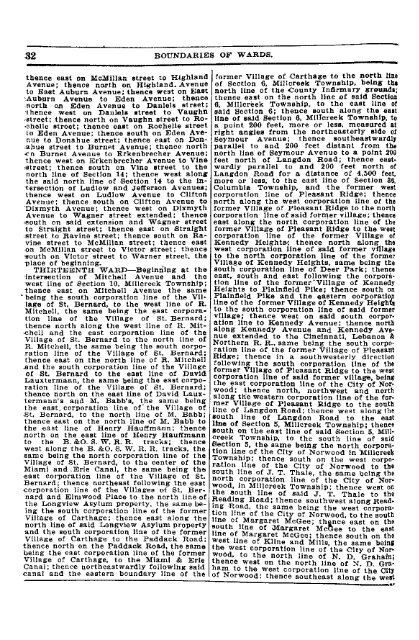
- Page 31 and 32: BOUNDARIES OF WARDS AND DIRECTORY O
- Page 33: 30 mer Village of Linwood; thence w
- Page 37 and 38: 34 BOUNDARIES OP WARDS. west line o
- Page 39 and 40: 36 ly following said north corporat
- Page 41 and 42: 38 STREET DIRECTORY. ALFRED, from 2
- Page 43 and 44: 40 STREET DIRECTORY. AUTEN AV., sou
- Page 45 and 46: 42 STREET DIRECTORY. BELLEVUE 'AV.,
- Page 47 and 48: 44 STREET DIRECTORY. BRACHMAN-AV.,
- Page 49: 46 STREET DIRECTORY. CADILLAC AV.,
- Page 52 and 53: CHIOKERING AV., east of Mitchell Av
- Page 54 and 55: :OM/FORT. first east of Coleraln Av
- Page 56 and 57: CYPRESS, south of MdMIllan, from Fr
- Page 58 and 59: DIXMONT AV., south of St. Leg«r Pl
- Page 60 and 61: EDEN PARK TERRACE, from 2100 Sinton
- Page 62 and 63: 3394 Herschel Av. 4200 Arnsby PI. 4
- Page 64 and 65: FINCH ALLEY, east of Copeland, from
- Page 66 and 67: 627 Butler. 1100 Parsons. 1200 Whit
- Page 68 and 69: GLENWAY AV., north and west from 23
- Page 71 and 72: 68 STREET DIRECTORY. HARVEST AV.. n
- Page 73 and 74: 70 STREET DIRECTORY. HOLLISTER (Eas
- Page 75 and 76: 72 STREET DIRECTORY. JACKSON, from
- Page 77 and 78: 74 KINGSTON PLACE, north from 2542
- Page 79 and 80: 76 STREET DIRECTORY. LEE PLACE, wes
- Page 81 and 82: 78 STREET DIRECTORY. LOCUST, change
- Page 83 and 84: 80 294 Manchestex Av 400 Byron. 414
- Page 85 and 86:
82 STREET DIRECTORY. 2800 McMicken
- Page 87 and 88:
84 STREET DIRECTORY. MOLINE COURT,
- Page 89 and 90:
86 STREET DIRECTORY. NICHOLAS ALLEY
- Page 91 and 92:
88 ST-REET DIRECTORY. ORMOND AV., f
- Page 93 and 94:
90 PHILOMENA AV., north of Frederic
- Page 95 and 96:
92 STREET DIRECTORY. QUARRY, west o
- Page 97 and 98:
94 STREET DIRECTORY. RIPPEY AV., ea
- Page 99 and 100:
96 STREET DIRECTORY. SALEM, south o
- Page 101 and 102:
98 STREET DIRECTORY. SEYBOLD ALLEY,
- Page 103 and 104:
100 STREET DIRECTORY. SPRING AV., c
- Page 105 and 106:
102 STREET DIRECTORY. 800 E. Sth. 9
- Page 107 and 108:
104 STREET DIRECTORY. TREVOR PLACE,
- Page 109 and 110:
106 STREET DIRECTORY. VIRGINIA AV.,
- Page 111 and 112:
108 STREET DIRECTORY. WERNER, north
- Page 113:
110 STREET DIRECTORY. WOLD AV., nor
- Page 116 and 117:
Brooklyn Flats 3440 Harvey Av Brook
- Page 118 and 119:
PUBLIC BUILDINGS, FLATS, ETC. 115 J
- Page 120 and 121:
St John's Hall w s Bremen b Green a
- Page 122 and 123:
WILLIAMS* Cincinnati Industrial, Me
- Page 124 and 125:
ADA CINCINNATI REGISTER. AEO 121 Ad
- Page 126 and 127:
ALB CINCINNATI REGISTER. ALL 123 Al
- Page 128 and 129:
AME CINCINNATI REGISTER. AME 125 Am
- Page 130 and 131:
AME CINCINNATI REGISTER. AND 127 Am
- Page 132 and 133:
ANT CINCINNATI REGISTER. ARM 129 An
- Page 134 and 135:
ART CINCINNATI REGISTER. ATL 131 Ar
- Page 136 and 137:
AUT CINCINNATI REGISTER. BAG 133 AU
- Page 138 and 139:
BAI CINCIN,NATI REGISTER. BAL 136 B
- Page 140 and 141:
BAR CINCINNATI REGISTER. BAR 137 Ba
- Page 142 and 143:
BAU CINCINNATI REGISTER. BAY 139 Ba
- Page 144 and 145:
BEC CINCINNATI REGISTER. BEX 141 Be
- Page 146 and 147:
BEN CINCINNATI REGISTER. BER 143 Be
- Page 148 and 149:
BER CINCINNATI REGISTER. BET 145 Be
- Page 150 and 151:
BIL CINCINNATI REGISTER. BLA 147 Bi
- Page 152 and 153:
BLO CINCINNATI REGISTER. BOA 149 Bl
- Page 154 and 155:
BOH CINCINNATI REGISTER. BOO 161 Bo
- Page 156 and 157:
BOT CINCINNATI REGISTER. BRA 153 Bo
- Page 158 and 159:
BRA CINCriNNATI REGISTER. BRE 155 B
- Page 160 and 161:
BRI CINCINNATI REGISTER. BRO 157 Br
- Page 162 and 163:
BRO CINCINNATI REGISTER. BRU 159 Br
- Page 164 and 165:
BUG CINCINNATI REGISTER. BUI 161 I
- Page 166 and 167:
BUR CINCINNATI REGISTER. BUR 163 Bu
- Page 168 and 169:
BUT CINCINNATI REGISTER. CAL 165 Bu
- Page 170 and 171:
CAM CINCINNATI REGISTER. Campbell M
- Page 172 and 173:
GAR CINCINNATI REGISTER. GAV 169 Ca
- Page 174 and 175:
GHA CINCINNATI REGISTER. GHE 171 Ch
- Page 176 and 177:
GHR CINCINNATI REGISTER. GIN 173 Ch
- Page 178 and 179:
GIN CINCINNATI REGISTER. GIN 175 CI
- Page 180 and 181:
GIN CINCINNATI REGISTER. GIN 177 Ci
- Page 182 and 183:
GIN CINCINNATI REGISTER. Cincinnati
- Page 184 and 185:
GIR CINCINNATI REGISTER. GLA 181 CI
- Page 186 and 187:
GLE CINCINNATI REGISTER. GLU 183 Cl
- Page 188 and 189:
GOH CINCINNATI REGISTER. GOL 185 -f
- Page 190 and 191:
GOM CINCINNATI REGISTER. GON 187 Co
- Page 192 and 193:
GON CINCINNATI REGISTER. GOP 189 Co
- Page 194 and 195:
GOS CINCINNATI REGISTER. GOX 191 Co
- Page 196 and 197:
GRA CINCINNATI REGISTER. GRO 193 Cr
- Page 198 and 199:
GUM CINCINNATI REGISTER. DAI 196 Cu
- Page 200 and 201:
DAT CINCINNATI REGISTER. DAV 197 Da
- Page 202 and 203:
DEG CINCINNATI REGISTER. DEN 199 De
- Page 204 and 205:
DEU Deutsch-Ungarlscher Bote (weekl
- Page 206 and 207:
DIN CINCINNATI REGISTER. DOD 203 DI
- Page 208 and 209:
DON CINCINNATI REGISTER. DOR 205 Do
- Page 210 and 211:
DRA CINCINNATI REGISTER. DUB 207 Dr
- Page 212 and 213:
DUN CINCINNATI REGISTER. EAG 209 DU
- Page 214 and 215:
EBE CINCINNATI REGISTER. EDW 211 Eb
- Page 216 and 217:
EHR CINCINNATI REGISTER. ELI 213 Eh
- Page 218 and 219:
EME CINCINNATI REGISTER. ENG 215 Em
- Page 220 and 221:
ERN CINCINNATI REGISTER. EVA 217 Er
- Page 222 and 223:
FAE CINCriNNATI REGISTER. FAR 219 F
- Page 224 and 225:
FED CINCINNATI REGISTER. FEN 221 Fe
- Page 226 and 227:
FIC CINCINNATI REGISTER. FIN 228 Fi
- Page 228 and 229:
FIS CINCINNATI REGISTER. FIT 225 Fi
- Page 230 and 231:
FLO CINCINNATI REGISTER. FOR 227 FL
- Page 232 and 233:
FOU CINCINNATI REGISTER. FRA 229 Fo
- Page 234 and 235:
FRA CINCINNATI REGISTER. FRE 231 Fr
- Page 236 and 237:
FRI CINCINNATI REGISTER. FRY 233 Pr
- Page 238 and 239:
GAI CINCINNATI REGISTER. GAR 235 Ga
- Page 240 and 241:
GEB CINCINNATI REGISTER. GEN 237 Ge
- Page 242 and 243:
GER CINCINNATI REGISTER. GIB 239 Ge
- Page 244 and 245:
GIL CINCINNATI REGISTER. Gilsey Mfg
- Page 246 and 247:
GOL CINCINNATI REGISTER. GOO 243 Go
- Page 248 and 249:
GRA CINCINNATI REGISTER. GRA 245 Gr
- Page 250 and 251:
GRE CINCINNATI REGISTER. GRE ^47 Gr
- Page 252 and 253:
GRO CINCINNATI REGISTER. GRU 249 Gr
- Page 254 and 255:
GWI CINCINNATI REGISTER. HAG 251 Gw
- Page 256 and 257:
HAL CINCINNATI REGISTER. HAM 253 Ha
- Page 258 and 259:
HAR CINCINNATI REGISTER. HAR 255 Ha
- Page 260 and 261:
HAR CINCINNATI REGISTER. HAT 257 Ha
- Page 262 and 263:
HAW CINCINNATI REGISTER. HEE 259 Ha
- Page 264 and 265:
HEI CINCINNATI REGISTER. HEL 261 He
- Page 266 and 267:
HEP CINCINNATI REGISTER. HER 263 He
- Page 268 and 269:
HEU CINCINNATI REGISTER. HIL 265 ge
- Page 270 and 271:
HIN CINCINNATI REGISTER. HOD 267 Hi
- Page 272 and 273:
HOF CINCINNATI REGISTER. HOL 269 Ho
- Page 274 and 275:
HOM CINCINNATI REGISTER. HOP 271 Ho
- Page 276 and 277:
HOT CINCINNATI REGISTER. HOW 273 HO
- Page 278 and 279:
HUE CINCINNATI REGISTER. HUM 275 HL
- Page 280 and 281:
HUS CINCINNATI REGISTER. HYP 277 Hu
- Page 282 and 283:
IND CINCINNATI REGISTER. INT 279 In
- Page 284 and 285:
JAC CINCINNATI REGISTER. JAH 281 Ja
- Page 286 and 287:
JEN CINCINNATI REGISTER. JOH 283 Je
- Page 288 and 289:
JON CINCINNATI REGISTER. JOS 285 Jo
- Page 290 and 291:
KAA CINCINNATI REGISTER. KAN 287 -
- Page 292 and 293:
KAU CINCINNATI REGISTER. KEL 289 Ka
- Page 295 and 296:
292 KEY CINCINNATI REGISTER. KIN Ke
- Page 297 and 298:
294 KIS CINCINNATI REGISTER. KLE Ki
- Page 299 and 300:
296 KNA CINCINNATI REGISTER. KOC Kn
- Page 301 and 302:
298 KOH CINCINNATI REGISTER. KRA Ko
- Page 303 and 304:
300 KRI CINCINNATI REGISTER. KRU Kr
- Page 305 and 306:
302 KUH Kuhlmann Jos A carp 425 Wad
- Page 307 and 308:
304 LAM CINCINNATI REGISTER. LAN La
- Page 309 and 310:
306 LAW Law, Uni6n & Rock Ins Co (L
- Page 311 and 312:
308 LEM CINCINNATI REGISTER. LEV Le
- Page 313 and 314:
310 LEW CINCINNATI REGISTER. LIL Le
- Page 315 and 316:
312 LIP LIPP THE LOUIS COMPANY, Lou
- Page 317 and 318:
314 LOH CINCINNATI REGISTER, LOT Lo
- Page 319 and 320:
316 LUD CINCINNATI REGISTER. LUT Lu
- Page 321 and 322:
318 McC CINCINNATI REGISTER. McD Mc
- Page 323 and 324:
320 McG CINCINNATI REGISTER. McL Mc
- Page 325 and 326:
322 MAC CINCINNATI REGISTER. MAG Ma
- Page 327 and 328:
324 MAN CINCINNATI REGISTER. MAR Ma
- Page 329 and 330:
326 MAR CINCINNATI REGISTER. MAR Ma
- Page 331 and 332:
328 MAT MATTHEWS & MATTHEWS, Attorn
- Page 333 and 334:
330 MEI CINCINNATI REGISTER. MER Me
- Page 335 and 336:
332 MES CINCINNATI REGISTER. MET Me
- Page 337 and 338:
334 MEY Meyer Tina dressmkr 1534 Ce
- Page 339 and 340:
336 MIL CINCINNATI, REGISTER. MIL M
- Page 341 and 342:
338 MIT CINCINNATI REGISTER, MOE Mi
- Page 343 and 344:
340 MON CINCINNATI REGISTER. MOO Mo
- Page 345 and 346:
342 MOR Mor'ris Edna J dentist 4006
- Page 347 and 348:
344 MUE CINCINNATI REGISTER. MUL Mu
- Page 349 and 350:
346 MUR Murphy W H treas The Willia
- Page 351 and 352:
348 NAT CINCINNATI REGISTER. NAT Na
- Page 353 and 354:
350 NEL Nelson Minnie confec 508 W
- Page 355 and 356:
352 NEY CINCINNATI REGISTER. NIE Xe
- Page 357 and 358:
354 NOR CINCINNATI REGISTER. NOT No
- Page 359 and 360:
356 OBE CINCINNATI REGISTER. OGD Ob
- Page 361 and 362:
358 OHI CINCINNATI REGISTER. OLD OH
- Page 363 and 364:
360 O'RO CINCINNATI REGISTER. OTT O
- Page 365 and 366:
362 PAI CINCINNATI REGISTER. PAR Pa
- Page 367 and 368:
364 PAT CINCINNATI REGISTER. PEC PA
- Page 369 and 370:
366 PEO -CINCINNATI REGISTER. PET P
- Page 371 and 372:
368 PHI CINCINNATI REGISTER. PIE Ph
- Page 373 and 374:
370 PLA CINCINNATI REGISTER. POH Pi
- Page 375 and 376:
372 POR CINCINNATI REGISTER. PRA Po
- Page 377 and 378:
374 PRO Procter & Collier Co (The)
- Page 379 and 380:
376 QUE CINCINNATI REGISTER. QUE Qu
- Page 381 and 382:
378 RAB CINCINNATI REGISTER. RAN Ra
- Page 383 and 384:
380 RAT Rattner Benj installments 5
- Page 385 and 386:
382 REI CINCINNATI REGISTER. REL Re
- Page 387 and 388:
384 RET CINCINNATI REGISTER. RIC Re
- Page 389 and 390:
386 RIE CINCINNATI REGISTER. RIT Ri
- Page 391 and 392:
388 ROB CINCINNATI REGISTER. ROE Ro
- Page 393 and 394:
390 ROM CINCINNATI REGISTER. ROS RO
- Page 395 and 396:
392 ROT CINCINNATI REGISTER. RUB Ro
- Page 397 and 398:
394 RUP CINCINNATI REGISTER. RYA Ru
- Page 399 and 400:
396 SAI CINCINNATI REGISTER, SAN St
- Page 401 and 402:
398 SAV CINCINNATI REGISTER. SCH Sa
- Page 403 and 404:
400 SCH CINCINNATI REGISTER. SCH Sc
- Page 405 and 406:
402 SCH CINCINNATI REGISTER. SCH Sc
- Page 407 and 408:
404 SCH CINCINNATI REGISTER. SCH Sc
- Page 409 and 410:
406 SCH CINCINNATI REGISTER. SCH Sc
- Page 411 and 412:
408 SCH CINCINNATI REGISTER. SEC Sc
- Page 413 and 414:
410 SEI CINCINNATI REGISTER. SEY Se
- Page 415 and 416:
412 SHE CINCINNATI REGISTER. SHO SH
- Page 417 and 418:
414 SIE CINCINNATI REGISTER. SIM Si
- Page 419 and 420:
416 SLO Slough Carl secy The Federa
- Page 421 and 422:
418 SMO Smokeless Fuel Co, Justus C
- Page 423 and 424:
420 SPA Sparkling Waters from Bible
- Page 425 and 426:
422 STA CINCINNATI REGISTER. STA
- Page 427 and 428:
424 STA CINCINNATI REGISTER. STE st
- Page 429 and 430:
426 STE CINCINNATI REGISTER. STE ST
- Page 431 and 432:
428 STE CINCINNATI REGISTER. STO St
- Page 433 and 434:
430 STR CINCINNATI REGISTER. STR St
- Page 435 and 436:
432 SUI CINCINNATI REGISTER. SUP SU
- Page 437 and 438:
434 SYP CINCINNATI REGISTER. TAY Sy
- Page 439 and 440:
436 TEN CINCINNATI REGISTER. THE Te
- Page 441 and 442:
438 THO CINCINNATI REGISTER. TIE TH
- Page 443 and 444:
440 TOE CINCINNATI REGISTER. TRA To
- Page 445 and 446:
442 TRI CINCINNATI REGISTER. TUR TR
- Page 447 and 448:
444 ULL CINCINNATI REGISTER. UNI Ul
- Page 449 and 450:
446 UNI United States Civil Service
- Page 451 and 452:
448 USE CINCINNATI REGISTER. VAN Us
- Page 453 and 454:
450 VIL Vlllnsky Benj propr Laurel
- Page 455 and 456:
452 WAG Wagner & Boehnin,S contrs 1
- Page 457 and 458:
454 WAL CINCINNATI REGISTER. WAR Wa
- Page 459 and 460:
456 WEB CINCINNATI REGISTER. WEH We
- Page 461 and 462:
458 WEI Weiner Jos Moses shoemkr 65
- Page 463 and 464:
460 WER CINCINNATI REGISTER. WES We
- Page 465 and 466:
462 WES CINCINNATI REGISTER. WHE WE
- Page 467 and 468:
464 WHI CINCINNATI REGISTER. WIG Wh
- Page 469 and 470:
466 WIL Willey S B pres The Willey
- Page 471 and 472:
468 WIN Wlndmiller Carrie nurse 261
- Page 473 and 474:
470 WIT CINCINNATI REGISTER. WOL WI
- Page 475 and 476:
472 WOO CINCINNAIT REGISTER. WRI Wo
- Page 477 and 478:
474 YAE CINCINNATI REGISTER. YOU Ya
- Page 479:
476 ZIE CINCINNATI REGISTER. ZWI Zl
- Page 482 and 483:
Cincinnati WILLIAMS' Industrial, Me
- Page 484 and 485:
The City Directory points the way b
- Page 486 and 487:
ADDRESSING 481 ADVERTISING ADDRESSI
- Page 488 and 489:
ALTAR 483 ARCHITECTS Altar Wines. S
- Page 490 and 491:
ART 485 ARTISTS Art Publishers. Gib
- Page 492 and 493:
ATTORNEYS 487 ATTORNEYS Bailey Geo
- Page 494 and 495:
ATTORNEYS 489 ATTORNEYS JOHN O. ECK
- Page 496 and 497:
ATTORNEYS 491 ATTORNEYS Hicks L R 5
- Page 498 and 499:
ATTORNEYS 493 ATTORNEYS MILLS GEO.
- Page 500 and 501:
ATTORNEYS 496 ATTORNEYS SCHWAB Sc M
- Page 502 and 503:
AUCTIONEERS 497 AUTOMOBILES Auction
- Page 504 and 505:
AUTOMOBILE 499 AUTOMOBILE Gem Garag
- Page 506 and 507:
AUTOMOBILE 501 AUTOMOBILE Motor Tru
- Page 508 and 509:
AWNINGS 503 BAKERIES SCHERZ JOHN SO
- Page 510 and 511:
BAKERIES 505 BANKS Seekatz Edward 1
- Page 512 and 513:
BANKS 507 BARBER UNITY BANKING & SA
- Page 514 and 515:
BARBER 509 BARBER Hoffman Anton 601
- Page 516 and 517:
BARBER 511 BEER » • ' • •
- Page 518 and 519:
BILLIARD 513 BILLING BalU & Heidebr
- Page 520 and 521:
BOARDING 515 BOILER Baumann Chas L
- Page 522 and 523:
BOND 517 BOOK FORBUS J. F. st CO.,
- Page 524 and 525:
BOTTLERS 619 BRASS Bottlers' Suppli
- Page 526 and 527:
BREWERIES 521 BRICK WIEDEMANN THE G
- Page 528 and 529:
BROKERS 523 BROKERS (Canned Goods.)
- Page 530 and 531:
BROKERS 525 BUILDING Clarkson & Cla
- Page 532 and 533:
BUSINESS 527 BUTTON Yi M. G. A. Day
- Page 534 and 535:
CAP 529 CARPENTERS Okrent Harry 3d
- Page 536 and 537:
CARPENTERS 531 CARPENTERS Klaserner
- Page 538 and 539:
CARRIAGE 538 CATERERS LUTH CARRIAGE
- Page 540 and 541:
CEMENT 535 CHECKS KUHL THE OHAS. AR
- Page 542 and 543:
CHILDREN'S 537 CHURCH Children's Ve
- Page 544 and 545:
CIGAR 539 CIGARS KIrstein H L & Co
- Page 546 and 547:
CIRCULAR 541 CLERGYMEN CRAWFORD ADD
- Page 548 and 549:
CLERGYMEN 543 CLERGYMEN Foreman Hen
- Page 550 and 551:
CLERGYMEN 545 CLERGYMEN Reiner Jos
- Page 552 and 553:
CLOTHIERS 547 CLOTHING Clothiers' S
- Page 554 and 555:
CLOTHING 549 COAL Foley Bros 523 an
- Page 556 and 557:
COAL 551 COAL Brown's W H Son Coal
- Page 558 and 559:
COAL 553 COLD Stearns Coal & Lumber
- Page 560 and 561:
COLLECTORS 555 COMMISSION Merchants
- Page 562 and 563:
COMMISSION 557 CONFECTIONERS (Wines
- Page 564 and 565:
CONFECTIONERS 559 CONFECTIONERS Cyr
- Page 566 and 567:
CONFECTIONERS 561 CONFECTIONERS Pet
- Page 568 and 569:
CONTRACTORS 563 CONTRACTORS Molloy
- Page 570 and 571:
CONTRACTORS 565 CORKS Hollaender Wa
- Page 572 and 573:
CREOSOTE 567 DAILY Creosote (Wholes
- Page 574 and 575:
DAILY 569 DAILY JfessUng H Jos 2T16
- Page 576 and 577:
DAIRIES 671 DANCING Buschelmann Alo
- Page 578 and 579:
DENTISTS 573 DENTISTS Becker Thos A
- Page 580 and 581:
DENTISTS 575 DIE Toungson Jas R 141
- Page 582 and 583:
DISTILLERS 577 DRAYAGE Klein Bros 2
- Page 584 and 585:
DRESSMAKERS 679 DRESSMAKERS ISampbe
- Page 586 and 587:
DRESSMAKERS 581 DRESSMAKERS Lefeber
- Page 588 and 589:
DRESSMAKERS 583 DRUGGISTS Weagly Cl
- Page 590 and 591:
DRUGGISTS 585 DRY park Drug Store n
- Page 592 and 593:
DRY 587 DUSTERS Lehner Mary C 2811
- Page 594 and 595:
ELECTRIC 589 ELECTRIC MOORMANN & OT
- Page 596 and 597:
ELECTRICAL 591 ELECTRICIANS Electri
- Page 598 and 599:
ELEVATOR 593 EMERY Reedy The H J Co
- Page 600 and 601:
ENGINEERS 595 ENGRAVERS Engineers'
- Page 602 and 603:
EXPRESS 597 FACIAL Eckerlln Express
- Page 604 and 605:
FEED 599 FIRE Early & Daniel Co (Th
- Page 606 and 607:
FLAVORING 601 FLORISTS Flavoring Ex
- Page 608 and 609:
FORWARDING 603 FRUITS Bekins Househ
- Page 610 and 611:
FRUIT 605 FURNISHED Nogen Louis 631
- Page 612 and 613:
FURNISHED 607 FURNITURE Samson Maud
- Page 614 and 615:
FURNITURE 609 GARDENERS Furniture P
- Page 616 and 617:
GARDENERS 611 GAS winkelmann- Fred
- Page 618 and 619:
GAS 613 GILDteRS Gas Furnaces and B
- Page 620 and 621:
GOLD 615 GRAPHOPHONES Gold and Silv
- Page 622 and 623:
GROCERS 617 GROCERS Arllnghaus Jos
- Page 624 and 625:
GROCERS 619 GROCERS Hamad Jos 216 B
- Page 626 and 627:
GROCERS 621 GROCERS Metz Geo 815 Fr
- Page 628 and 629:
GROCERS 623 GROCERS Tenner Rosa 171
- Page 630 and 631:
HANDICRAFT 625 HARDWOOD Handicraft
- Page 632 and 633:
HEALTH 627 HOOP Health and Physical
- Page 634 and 635:
HOSE 629 HOTELS Hose and Belting. B
- Page 636 and 637:
HOUSE 631 ICE WESTEBN WBECKING St C
- Page 638 and 639:
INSECT 688 INSURANCE SOIITHEBN CHEM
- Page 640 and 641:
INSURANCE 685 INSURANCE CAREY & ZIM
- Page 642 and 643:
INSURANCE 637 INSURANCE Morgan Noah
- Page 644 and 645:
INSURANCE 639 INSURANCE SUN MUTUAL
- Page 646 and 647:
INSURANCE 641 INSURANCE Continental
- Page 648 and 649:
INSURANCE 643 INSURANCE Manhattan L
- Page 650 and 651:
INSURANCE 645 INSURANCE Pacific Mut
- Page 652 and 653:
INTERSTATE 647 IRON Interstate Comm
- Page 654 and 655:
IRON 649 IRON STEEL&IRONGO. CINCINN
- Page 656 and 657:
JOB 661 LADIES Cohh Jacob 16 W 3d G
- Page 658 and 659:
LADIES 653 LAUNDRIES Schwenker M B
- Page 660 and 661:
LEAD 655 LIME Lead Trap and Bend IV
- Page 662 and 663:
LITHOGRAPHERS 667 LOAN Macbrair Wm
- Page 664 and 665:
LODGING 659 LUMBER 'PHONE WEST 1230
- Page 666 and 667:
LUMBER 661 LUMBER New River Lumber
- Page 668 and 669:
MACHINE 663 MACHINERY EASTERN MACHI
- Page 670 and 671:
MACHINERY 665 MACHINISTS Tatum The
- Page 672 and 673:
MANICURES 667 MANUFACTURERS Manicur
- Page 674 and 675:
MANUFACTURERS 669 MANUFACTURERS (Fl
- Page 676 and 677:
MANUFACTURERS 671 MANUFACTURERS (Sa
- Page 678 and 679:
MASSAGE 673 MEDICAL DeLaCroix TUlle
- Page 680 and 681:
MEN'S 675 MERRYGO-ROUND Feldhaus Fr
- Page 682 and 683:
METALS 677 MILLINERY HILB & BAUEB,
- Page 684 and 685:
MILL 679 MODEL VULCAN SUPPLY CO. (T
- Page 686 and 687:
MOVING 681 MOVING General FUm Co (I
- Page 688 and 689:
MUSIC 683 MUSIC Bohlander Lillian 8
- Page 690 and 691:
MUSIC 685 MUSICAL Sandau Neva Remde
- Page 692 and 693:
NEWS 687 NEWSPAPERS HaU Grlfllth C
- Page 694 and 695:
NEWSPAPERS 689 NOTARIES University
- Page 696 and 697:
NOTARIES 691 NOTARIES Darby Thos H
- Page 698 and 699:
NOTARIES 693 NOTARIES Lawton Geo W
- Page 700 and 701:
NOTARIES 695 NOTARIES Schwinn J C 4
- Page 702 and 703:
NOTIONS 697 NURSES ShUUto The John
- Page 704 and 705:
NURSES 699 NURSES Loos Emma 2356 St
- Page 706 and 707:
OCULISTS 701 OILS Lamb Fred W 24 E
- Page 708 and 709:
OPTICIANS 703 OSTEOPATHIC Geneva Op
- Page 710 and 711:
PAINT 705 PAINTERS Monitor Paint Co
- Page 712 and 713:
PAINTERS 707 PANTS Palmer Geo n s D
- Page 714 and 715:
PAPER 709 PATENT BROWNE & STUART CO
- Page 716 and 717:
PATTERN 711 PHOTOGRAPHERS Pattern M
- Page 718 and 719:
PHYSICIANS 713 PHYSICIANS Ayres Wyl
- Page 720 and 721:
PHYSICIANS 715 PHYSICIANS Heyn Dani
- Page 722 and 723:
PHYSICIANS 717 PHYSICIANS Sandfeld
- Page 724 and 725:
PIANO 719 PIANOS Tfi «I>iANO One o
- Page 726 and 727:
PIANO 721 PIG Piano Repairers. Brow
- Page 728 and 729:
PLASTERERS 723 PLUMBAGO Bunyan Wm C
- Page 730 and 731:
PLUMBERS 725 PLUMBERS Plumbers—Co
- Page 732 and 733:
PORTLAND 727 POWER Portland Cement.
- Page 734 and 735:
PRINTERS 729 PRINTERS CRESCENT PRIN
- Page 736 and 737:
PRINTING 731 PUMPS Printing Machine
- Page 738 and 739:
RAILROAD 733 REAL Railroad Equipmen
- Page 740 and 741:
REAL 735 REAL ERKENBBECHEB ALBEBT G
- Page 742 and 743:
REAL 737 REALTOR Hossieter W R 905
- Page 744 and 745:
REFRIGERATORS 739 RESTAURANTS Van T
- Page 746 and 747:
RESTAURANTS 741 ROOFERS Stuckenberg
- Page 748 and 749:
ROOFING 743 RUBBER Porter Iron Roof
- Page 750 and 751:
SAFE 745 SALOONS Phenix Safe Co 600
- Page 752 and 753:
SALOONS 747 SALOONS Grellleh Martin
- Page 754 and 755:
SALOONS 749 SALOONS Patmor Guy 1325
- Page 756 and 757:
SAMPLE 761 SAUSAGE MENZEL TRUNK CO.
- Page 758 and 759:
SCHOOLS 753 SECOND-HAND Notre Dame
- Page 760 and 761:
SEWER 755 SEWING CINCINNATI SEWER P
- Page 762 and 763:
SHIRT 757 SHOES GOLDE GEO, & CO., C
- Page 764 and 765:
SHOE 759 SHOE Belgard F A 1112 Broa
- Page 766 and 767:
SHOE 761 SHOE Weber Frank J 3114 Wa
- Page 768 and 769:
SIGNS 763 SILVER ESTIMATES SUBMITTE
- Page 770 and 771:
SOCIETY 765 SPRAYING Society Goods.
- Page 772 and 773:
STATIONERY 767 STEAMSHIP Stationery
- Page 774 and 775:
STEEL 769 STOGIE DOUGLAS A. BROWN S
- Page 776 and 777:
STONEWARE 771 STOVE Stoneware Pipe.
- Page 778 and 779:
STRUCTURAL 773 TABULATING Structura
- Page 780 and 781:
TAILORS 775 TAILORS Cordenbrok Henr
- Page 782 and 783:
TAILOR 777 TALKING Hauenstein Wm 46
- Page 784 and 785:
TEAMSTERS 779 TEAS Bertram G Thos 1
- Page 786 and 787:
TILE 781 TINNERS Tile. Casslnl The
- Page 788 and 789:
TOBACCO 783 TOOLS Tobacco, Wholesal
- Page 790 and 791:
TRANSPORTATION 785 TWINES Transport
- Page 792 and 793:
TYPEWRITTEN + Typewritten Letters.
- Page 794 and 795:
UPHOLSTEliERS 789 VARNISH Lindner E
- Page 796 and 797:
VETERINARY 791 WAGON Byard H N 3570
- Page 798 and 799:
WALL 793 WARM Harvie Chas R 5514 Co
- Page 800 and 801:
WATCHES 795 WATER Greenwald Jewelry
- Page 802 and 803:
WHISKIES 797 WHITEWASHERS Malvern D
- Page 804 and 805:
WINES 799 WIRE FRIES ALEX. St BBO.,
- Page 806 and 807:
WOODEN 801 ZOOLOGICAL Wooden Shoes.
- Page 808 and 809:
CLUB REGISTER Giving the Names and
- Page 810 and 811:
Neumann W A 401 Gwynne Bldg North T
- Page 812 and 813:
Baehr Arthur 229 W 6th Bav Julius 1
- Page 814 and 815:
Bury Anthony 409( York Busam Jos 60
- Page 816 and 817:
Doerman Chas H 318 B 3d Doerr Chas
- Page 818 and 819:
Galbraith F W jr, Lafayette Circle,
- Page 820 and 821:
Herzog Morris, Hotel Alms Herzstam
- Page 822 and 823:
King Rufus 352 Lafayette Av Kingery
- Page 824 and 825:
McKenzie Wm S 4015 Cherry McKim G F
- Page 826 and 827:
Nichols Alfred, Cin'tl Car Co Nicho
- Page 828 and 829:
Rippey W C 4470 Eastern Av Ritter A
- Page 830 and 831:
Slkes Geo O 6326 Ridge Av Pleasant
- Page 832 and 833:
Vail Dr D T 24 E Sth VanCamp B T 2
- Page 834 and 835:
BUSINESS MEN'S CLUB 829 The BUSINES
- Page 836 and 837:
Conway J J 112 E Sth Cook Edward F,
- Page 838:
Griess Ernest 810 Sycamore Griffith
- Page 841 and 842:
836 BUSINESS MEN'S CLUB Mayer Jesse
- Page 843 and 844:
838 BUSINESS MEN'S CLUB Sacket P J
- Page 845 and 846:
840 BUSINESS MEN'S CLUB Wiggers H H
- Page 847 and 848:
842 CINCINNATI ART CLUB Uppert Leon
- Page 849 and 850:
844 CINCINNATI BUSINESS WOMEN'S CLU
- Page 851 and 852:
846 CINCINNATI CHAMBER OF COMMERCE
- Page 853 and 854:
848 CINCINNATI CHAMBER OF COMMERCE
- Page 855 and 856:
850 CINCINNATI CHAMBER OF COMMERCE
- Page 857 and 858:
852 CINCINNATI CHAMBER OF COMMERCE
- Page 859 and 860:
854 CINCINNATI CHAMBER OF COMMERCE
- Page 861 and 862:
856 CINCINNATI CHAMBER OF COMMERCE
- Page 863 and 864:
858 CINCINNATI CHAMBER OF COMMERCE
- Page 865 and 866:
860 CINCINNATI CHAMBER OF COMMERCE
- Page 867 and 868:
862 CINCINNATI CHAMBER OF COMMERCE
- Page 869 and 870:
864 CINCINNATI CHAMBER OF COMMERCE
- Page 871 and 872:
866 Freeman W W s w c 4th and Plum
- Page 873 and 874:
868 CINCINNATI ROTARY CLUB WlUey G
- Page 875 and 876:
870 Dunham Mrs Henry Kennon 2503 Au
- Page 877 and 878:
872 CINCINNATI WOMAN'S CLUB Lyford
- Page 879 and 880:
874 CINCINNATI WOMAN'S CLUB Smith M
- Page 881 and 882:
876 CINCINNATI WOMAN'S CITY CLUB Ba
- Page 883 and 884:
878 CINCINNATI WOMAN'S CITY CLUB Ea
- Page 885 and 886:
880 CINCINNATI WOMAN'S CITY CLUB Ho
- Page 887 and 888:
882 CINCINNATI WOMAN'S CITY CLUB Me
- Page 889 and 890:
884 CINCINNATI WOMAN'S CITY CLUB Sh
- Page 891 and 892:
886 CINCINNATI YALE CLUB THE CINCIN
- Page 893 and 894:
888 CITY CLUB Bayless H A 97 Carew
- Page 895 and 896:
890 CITY CLUB Hebble C R, Chamber o
- Page 897 and 898:
892 CITY CLUB Rauh Julian S 9th and
- Page 899 and 900:
894 COMMERCIAL CLUB THE COMMERCIAL
- Page 901 and 902:
896 CUVIER-PRESS CLUB Brown Lewis F
- Page 903 and 904:
898 CUVIER-PRESS CLUB Heher John 6,
- Page 905 and 906:
900 CUVIER-PRESS CLUB Nichols C C 1
- Page 907 and 908:
902 CUVIER-PRESS CLUB TomUnson E C,
- Page 909 and 910:
904 HARVARD CLUB Ellis John DeM 111
- Page 911 and 912:
906 KIWANIS CLUB Pumphrey Clarence
- Page 913 and 914:
908 LAUGHERY CLUB Maag Pred, Libert
- Page 915 and 916:
910 QUEEN CITY CLUB Edwards David G
- Page 917 and 918:
912 QUEEN CITY CLUB Woodrow C T fla
- Page 919 and 920:
914 UNIVERSITY CLUB OF CINCINNATI F
- Page 921 and 922:
The City Directory points the way b
- Page 923 and 924:
918 PARCEL POST GUIDE The parcel po
- Page 925 and 926:
920 PARCEL POST GUIDE FRAGILE. Frag
- Page 927 and 928:
922 ALABAMA—CALIFORNIA Note—All
- Page 929 and 930:
924 FLORIDA—GEORGIA Post Offlce.
- Page 931 and 932:
926 Post Offlce. Zone. Perry 4 Petr
- Page 933 and 934:
928 KANSAS—KENTUCKY Post Qffice.
- Page 935 and 936:
930 KENTUCKY Post Office. Zone. Pos
- Page 937 and 938:
932 MICHIGAN Post Offlce. Zone. Bre
- Page 939 and 940:
934 MINNESOTA Post Offlce. Zone. Po
- Page 941 and 942:
936 MISSOURI—MONTANA Post Office.
- Page 943 and 944:
938 Post Offlce. Zone. Whitlash 7 W
- Page 945 and 946:
940 NEW YORK—NORTH CAROLINA Post
- Page 947 and 948:
942 NORTH CAROLINA—NORTH DAKOTA P
- Page 949 and 950:
^44 OHIO Post Offlce. Zone. Copley
- Page 951 and 952:
346 OKLAHOMA. Zone 8, Except— JPo
- Page 953 and 954:
948 PENNSYLVANIA Post Offlce. Zone.
- Page 955 and 956:
960 PENNSYLVANIA—TENNESSEE Post O
- Page 957 and 958:
^52 TEXAS—UTAH Post Office. Zone.
- Page 959 and 960:
954 VIRGINIA Post Office. Zone. Pos
- Page 961 and 962:
956 WASHINGTON—WEST VIRGINIA —(
- Page 963 and 964:
958 Post Office. Zone. Post Offlce.
- Page 965:
tCbe Hssociation of Hmecican S)trec