Kent, C., Jackson, J., Borg, A., Sautreau, D - ARGANS
Kent, C., Jackson, J., Borg, A., Sautreau, D - ARGANS
Kent, C., Jackson, J., Borg, A., Sautreau, D - ARGANS

Create successful ePaper yourself
Turn your PDF publications into a flip-book with our unique Google optimized e-Paper software.
also evaluates ongoing investigations with regard to the<br />
calibration and scientific quality of the instrument, and<br />
future needs – such as reprocessing of the mission<br />
archive. The MERIS SPPA Team are also present at<br />
MERIS Validation Team (MVT) meetings, and provide<br />
support to the calibration teams through notifications<br />
regarding planned MERIS periods of unavailability.<br />
The MERIS SPPA Team also responds to external User<br />
requests via the ESA EO Helpdesk. This is<br />
supplemented by allowing the entire data QC<br />
procedures - including daily reporting and Long Loop<br />
Sensor Analysis (LLSA) - through a variety of media<br />
including: documentation, a newly-formed User forum<br />
entitled ODESA [4], and FAQs, with comments,<br />
feedback and questions actively encouraged to ensure<br />
the ongoing evolution of the data quality of the mission.<br />
2.4. ENVISAT 2010+<br />
The planned lifetime of the ENVISAT platform was due<br />
to be bought to a close in 2007. However, precise<br />
management of orbital control manoeuvres throughout<br />
the intended lifetime of the mission enabled enough fuel<br />
to be set aside to allow nominal operations to be<br />
extended for an additional 3.5 years (i.e. until the end of<br />
2010).<br />
However, by careful consideration of the individual<br />
instrument requirements, the mission will be extended<br />
to 2014. This extension, ENVISAT 2010+ [5], will be<br />
made possible by the reduction in altitude of the<br />
platform by approximately 17 km, and allowing the<br />
inclination to drift until the end of the mission –<br />
reducing the need for Orbital manoeuvres. The change<br />
in Orbit scenario will take place during the period 22 nd –<br />
26 th October 2010 with nominal data production -<br />
quality disclaimers will be included - expected to<br />
resume from 2 nd November 2010.<br />
The MERIS SPPA Team will play a significant role<br />
during this period by coordinating with the MERIS<br />
QWG to assess the newly-acquired products, and<br />
determine if they are of acceptable quality to be<br />
distributed. It should be stressed that no major impact to<br />
MERIS data is expected, but routine parameters such as<br />
geolocation and radiometric quality will be subjected to<br />
detailed scrutiny. Notifications concerning the status of<br />
MERIS and the acquired products will be through<br />
quality disclaimers distributed via EO Help, web forums<br />
and email correspondence.<br />
3. MODIS AND SEAWIFS SPPA<br />
MODIS and SeaWiFS are both monitored as Third<br />
Party Missions (TPM) [6] for ESA. MODIS (MODerate<br />
Resolution Imaging Spectroradiometer) is a key<br />
instrument aboard the NASA Terra (EOS AM) and<br />
Aqua (EOS PM) satellites [7]. Terra's orbit around the<br />
Earth is timed so that it passes from north to south<br />
across the equator in the morning, while Aqua passes<br />
south to north over the equator in the afternoon. The<br />
two MODIS instruments are viewing the entire Earth's<br />
surface every 1 to 2 days, acquiring data in 36 spectral<br />
bands [8].<br />
The SeaWiFS (Sea viewing Wide Field-of-view Sensor)<br />
instrument was launched onboard GeoEYE’s OrbView-<br />
2 satellite in 1997 into a sun-synchronous, descending,<br />
daytime orbit. SeaWiFS acquires radiometric<br />
measurements of the Earth’s surface in eight spectral<br />
bands (visible to NIR wavelengths) [9].<br />
3.1. MODIS and SeaWiFS Product Quality Control<br />
MODIS Level 1B products are available through the<br />
MERCI MODIS Catalogue System, an online archive<br />
from which Quicklooks, entire products, or sections of<br />
swaths can be downloaded by registered Users [10].<br />
Products are acquired via ESA Stations at Matera in<br />
Italy, Maspalomas on Gran Canaria, and Kiruna in<br />
Sweden. Product delivery is monitored on a daily basis,<br />
and feeds into the MODIS DR. Any product anomalies<br />
are investigated through interrogation using bespoke<br />
code developed at <strong>ARGANS</strong>; outputting invalid pixel<br />
statistics, the locations of any missing rows of data and<br />
a spectrum check in a PDF report.<br />
MODIS Aqua Level 1A and SeaWiFS Level 0 HRPT<br />
NRT products from the Matera and Maspalomas<br />
Receiving Stations are made available to Users as part<br />
of the GMES (Global Monitoring for the Environment<br />
and Security) MyOcean Dataset. MyOcean is the<br />
implementation project of the GMES Marine Core<br />
Service, aiming at deploying the first concerted and<br />
integrated pan-European capacity for Ocean Monitoring<br />
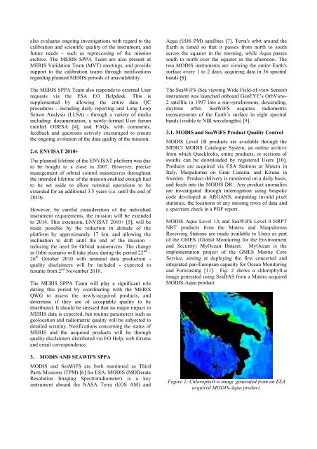
and Forecasting [11]. Fig. 2 shows a chlorophyll-α<br />
image generated using SeaDAS from a Matera acquired<br />
MODIS-Aqua product.<br />
Figure 2: Chlorophyll-α image generated from an ESA<br />
acquired MODIS-Aqua product.