3-DIM Observer
3-DIM Observer
3-DIM Observer

Create successful ePaper yourself
Turn your PDF publications into a flip-book with our unique Google optimized e-Paper software.
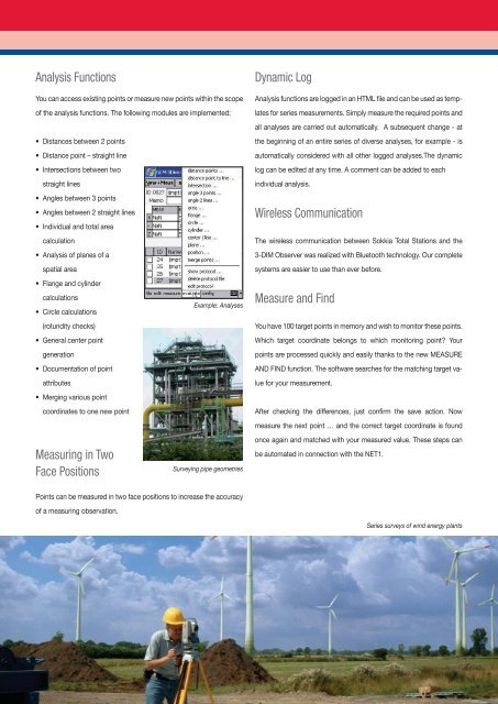
Analysis Functions<br />
You can access existing points or measure new points within the scope<br />
of the analysis functions. The following modules are implemented:<br />
• Distances between 2 points<br />
• Distance point – straight line<br />
• Intersections between two<br />
straight lines<br />
• Angles between 3 points<br />
• Angles between 2 straight lines<br />
• Individual and total area<br />
calculation<br />
• Analysis of planes of a<br />
spatial area<br />
• Flange and cylinder<br />
calculations<br />
• Circle calculations<br />
(rotundity checks)<br />
• General center point<br />
generation<br />
• Documentation of point<br />
attributes<br />
• Merging various point<br />
coordinates to one new point<br />
Measuring in Two<br />
Face Positions<br />
Points can be measured in two face positions to increase the accuracy<br />
of a measuring observation.<br />
Example: Analyses<br />
Surveying pipe geometries<br />
Dynamic Log<br />
Analysis functions are logged in an HTML fi le and can be used as temp-<br />
lates for series measurements. Simply measure the required points and<br />
all analyses are carried out automatically. A subsequent change - at<br />
the beginning of an entire series of diverse analyses, for example - is<br />
automatically considered with all other logged analyses.The dynamic<br />
log can be edited at any time. A comment can be added to each<br />
individual analysis.<br />
Wireless Communication<br />
The wireless communication between Sokkia Total Stations and the<br />
3-<strong>DIM</strong> <strong>Observer</strong> was realized with Bluetooth technology. Our complete<br />
systems are easier to use than ever before.<br />
Measure and Find<br />
You have 100 target points in memory and wish to monitor these points.<br />
Which target coordinate belongs to which monitoring point? Your<br />
points are processed quickly and easily thanks to the new MEASURE<br />
AND FIND function. The software searches for the matching target va-<br />
lue for your measurement.<br />
After checking the differences, just confi rm the save action. Now<br />
measure the next point … and the correct target coordinate is found<br />
once again and matched with your measured value. These steps can<br />
be automated in connection with the NET1.<br />
Series surveys of wind energy plants


![Gyro X II brochure [403KB]](https://img.yumpu.com/44354068/1/184x260/gyro-x-ii-brochure-403kb.jpg?quality=85)


![SHC2500.pdf [1.19 MB] - Sokkia Singapore](https://img.yumpu.com/31654015/1/184x260/shc2500pdf-119-mb-sokkia-singapore.jpg?quality=85)