Descargar - Instituto de Investigaciones de la Amazonía Peruana
Descargar - Instituto de Investigaciones de la Amazonía Peruana
Descargar - Instituto de Investigaciones de la Amazonía Peruana

You also want an ePaper? Increase the reach of your titles
YUMPU automatically turns print PDFs into web optimized ePapers that Google loves.
VEGETACIÓN<br />
[MESOZONIFICACIÓN ECOLÓGICA Y ECONÓMICA PARA EL DESARROLLO<br />
SOSTENIBLE DEL ÁMBITO DEL RÍO APURÍMAC (VRA)]<br />
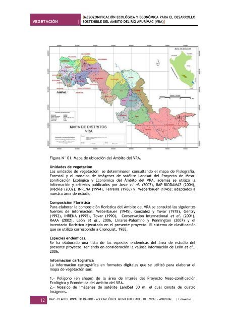
Figura N° 01. Mapa <strong>de</strong> ubicación <strong>de</strong>l Ámbito <strong>de</strong>l VRA.<br />
Unida<strong>de</strong>s <strong>de</strong> vegetación<br />
Las unida<strong>de</strong>s <strong>de</strong> vegetación se <strong>de</strong>terminaron consultando el mapa <strong>de</strong> Fisiografía,<br />
Forestal y el mosaico <strong>de</strong> imágenes <strong>de</strong> satélite Landsat <strong>de</strong>l Proyecto <strong>de</strong> Mesozonificación<br />
Ecológica y Económica <strong>de</strong>l Ámbito <strong>de</strong>l VRA, a<strong>de</strong>más se utilizó <strong>la</strong><br />
información y criterios publicados por Josse et al. (2007), IIAP-BIODAMAZ (2004),<br />
Breckle (2002), INRENA (1994), Ferreira (1986) y Weberbauer (1945); adaptados a<br />
nuestra área <strong>de</strong> estudio.<br />
Composición Florística<br />
Para e<strong>la</strong>borar <strong>la</strong> composición florística <strong>de</strong>l Ámbito <strong>de</strong>l VRA se consultó <strong>la</strong>s siguientes<br />
fuentes <strong>de</strong> información: Weberbauer (1945), Gonzalez y Tovar (1978), Gentry<br />
(1992), INRENA (1995), Tovar (1990), Conservation International et al. (2001),<br />
RAAA (2002), León et al., 2006, Linares-Palomino y Pennington (2007) y el<br />
inventario florístico ejecutado en el presente proyecto. El sistema <strong>de</strong> c<strong>la</strong>sificación<br />
que se utilizó correspon<strong>de</strong> a Cronquist, 1988.<br />
Especies endémicas.<br />
Se ha e<strong>la</strong>borado una lista <strong>de</strong> <strong>la</strong>s especies endémicas <strong>de</strong>l área <strong>de</strong> estudio <strong>de</strong>l<br />
presente proyecto, teniendo en consi<strong>de</strong>ración <strong>la</strong> valiosa información <strong>de</strong> León et al.,<br />
2006.<br />
Información cartográfica<br />
La información cartográfica en formatos digitales que se utilizó para e<strong>la</strong>borar el<br />
mapa <strong>de</strong> vegetación son:<br />
1.- Polígono (en shape) <strong>de</strong> <strong>la</strong> área <strong>de</strong> interés <strong>de</strong>l Proyecto Meso-zonificación<br />
Ecológica y Económica <strong>de</strong>l Ámbito <strong>de</strong>l VRA.<br />
2.- Mosaico <strong>de</strong> imágenes <strong>de</strong> satélite LandSat 30 m, el cual consta <strong>de</strong> cuatro<br />
imágenes.<br />
12 IIAP - PLAN DE IMPACTO RÁPIDO - ASOCIACIÓN DE MUNICIPALIDADES DEL VRAE - AMUVRAE | Convenio