Prólogo - índice - Instituto Oceanográfico de la Armada
Prólogo - índice - Instituto Oceanográfico de la Armada
Prólogo - índice - Instituto Oceanográfico de la Armada
You also want an ePaper? Increase the reach of your titles
YUMPU automatically turns print PDFs into web optimized ePapers that Google loves.
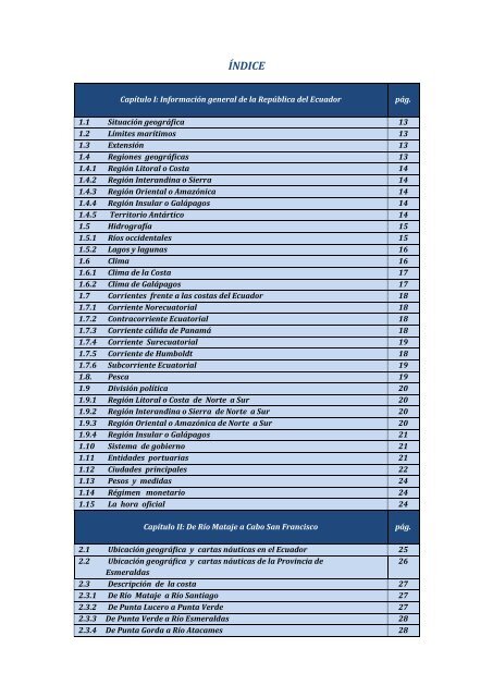
ÍNDICE<br />
Capítulo I: Información general <strong>de</strong> <strong>la</strong> República <strong>de</strong>l Ecuador<br />
1.1 Situación geográfica 13<br />
1.2 Límites marítimos 13<br />
1.3 Extensión 13<br />
1.4 Regiones geográficas 13<br />
1.4.1 Región Litoral o Costa 14<br />
1.4.2 Región Interandina o Sierra 14<br />
1.4.3 Región Oriental o Amazónica 14<br />
1.4.4 Región Insu<strong>la</strong>r o Galápagos 14<br />
1.4.5 Territorio Antártico 14<br />
1.5 Hidrografía 15<br />
1.5.1 Ríos occi<strong>de</strong>ntales 15<br />
1.5.2 Lagos y <strong>la</strong>gunas 16<br />
1.6 Clima 16<br />
1.6.1 Clima <strong>de</strong> <strong>la</strong> Costa 17<br />
1.6.2 Clima <strong>de</strong> Galápagos 17<br />
1.7 Corrientes frente a <strong>la</strong>s costas <strong>de</strong>l Ecuador 18<br />
1.7.1 Corriente Norecuatorial 18<br />
1.7.2 Contracorriente Ecuatorial 18<br />
1.7.3 Corriente cálida <strong>de</strong> Panamá 18<br />
1.7.4 Corriente Surecuatorial 19<br />
1.7.5 Corriente <strong>de</strong> Humboldt 18<br />
1.7.6 Subcorriente Ecuatorial 19<br />
1.8. Pesca 19<br />
1.9 División política 20<br />
1.9.1 Región Litoral o Costa <strong>de</strong> Norte a Sur 20<br />
1.9.2 Región Interandina o Sierra <strong>de</strong> Norte a Sur 20<br />
1.9.3 Región Oriental o Amazónica <strong>de</strong> Norte a Sur 20<br />
1.9.4 Región Insu<strong>la</strong>r o Galápagos 21<br />
1.10 Sistema <strong>de</strong> gobierno 21<br />
1.11 Entida<strong>de</strong>s portuarias 21<br />
1.12 Ciuda<strong>de</strong>s principales 22<br />
1.13 Pesos y medidas 24<br />
1.14 Régimen monetario 24<br />
1.15 La hora oficial 24<br />
Capítulo II: De Río Mataje a Cabo San Francisco<br />
2.1 Ubicación geográfica y cartas náuticas en el Ecuador 25<br />
2.2 Ubicación geográfica y cartas náuticas <strong>de</strong> <strong>la</strong> Provincia <strong>de</strong><br />
26<br />
Esmeraldas<br />
2.3 Descripción <strong>de</strong> <strong>la</strong> costa 27<br />
2.3.1 De Río Mataje a Río Santiago 27<br />
2.3.2 De Punta Lucero a Punta Ver<strong>de</strong> 27<br />
2.3.3 De Punta Ver<strong>de</strong> a Río Esmeraldas 28<br />
2.3.4 De Punta Gorda a Río Atacames 28<br />
pág.<br />
pág.


