Prólogo - índice - Instituto Oceanográfico de la Armada
Prólogo - índice - Instituto Oceanográfico de la Armada
Prólogo - índice - Instituto Oceanográfico de la Armada
Create successful ePaper yourself
Turn your PDF publications into a flip-book with our unique Google optimized e-Paper software.
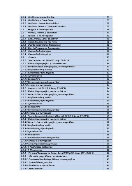
2.3.5 De Río Atacames a Río Súa 28<br />
2.3.6 De Río Súa a Punta Same 29<br />
2.3.7 De Punta Same a Punta Galera 29<br />
2.3.8 De Punta Galera a Cabo San Francisco 29<br />
2.4 Peligros a <strong>la</strong> navegación 29<br />
2.5 Mareas, vientos y corrientes 30<br />
2.6 Ayudas a <strong>la</strong> navegación 30<br />
2.6.1 San Lorenzo, Canal <strong>de</strong> Bolívar 30<br />
2.6.2 Canal <strong>de</strong> Limones y Río Ver<strong>de</strong> 31<br />
2.6.3 Puerto Comercial <strong>de</strong> Esmeraldas 31<br />
2.6.3.1 Puerto Pesquero <strong>de</strong> Esmeraldas 32<br />
2.6.4 Ensenada <strong>de</strong> Atacames 32<br />
2.6.5 Ensenada <strong>de</strong> Monpiche 32<br />
2.7 Puertos 33<br />
2.7.1 San Lorenzo Lat. 01 o 18’N. Long. 78 o 51’ W 33<br />
2.7.1.1 Ubicación geográfica y características 33<br />
2.7.1.2 Características hidrográficas y oceanográficas 33<br />
2.7.1.3 Profundida<strong>de</strong>s y veriles 33<br />
2.7.1.4 Gradientes y tipo <strong>de</strong> fondo 33<br />
2.7.1.5 Aproximación 33<br />
2.7.1.6 Fon<strong>de</strong>a<strong>de</strong>ro 34<br />
2.7.1.7 Recomendaciones <strong>de</strong> seguridad 34<br />
2.7.1.8 Ayudas a <strong>la</strong> navegación 34<br />
2.7.2 Limones Lat. 01 o 15’ N. Long. 79 o 00’ W. 34<br />
2.7.2.1 Ubicación geográfica y características 34<br />
2.7.2.2 Características hidrográficas y oceanográficas 34<br />
2.7.2.3 Profundida<strong>de</strong>s y veriles 35<br />
2.7.2.4 Gradientes y tipo <strong>de</strong> fondo 35<br />
2.7.2.5 Aproximación 35<br />
2.7.2.6 Fon<strong>de</strong>a<strong>de</strong>ro 35<br />
2.7.2.7 Recomendaciones <strong>de</strong> seguridad 35<br />
2.7.2.8 Ayudas a <strong>la</strong> navegación 35<br />
2.7.3 Puerto Comercial <strong>de</strong> Esmeraldas Lat. 01 o 00’ N. Long. 79 o 31’ W. 36<br />
2.7.3.1 Ubicación geográfica y características 36<br />
2.7.3.2 Características hidrográficas y oceanográficas 37<br />
2.7.3.3 Profundida<strong>de</strong>s y veriles 37<br />
2.7.3.4 Gradientes y tipo <strong>de</strong> fondo 38<br />
2.7.3.5 Aproximación 38<br />
2.7.3.6 Fon<strong>de</strong>a<strong>de</strong>ro 38<br />
2.7.3.7 Recomendaciones <strong>de</strong> seguridad 39<br />
2.7.3.8 Ayudas a <strong>la</strong> navegación 39<br />
2.7.3.9 Área <strong>de</strong> propósitos especiales 39<br />
2.7.3.10 Facilida<strong>de</strong>s portuarias 39<br />
2.7.3.11 Misceláneas 41<br />
2.7.4 Terminal Petrolero <strong>de</strong> Ba<strong>la</strong>o Lat. 00°58’.60 N. Long. 079°40’.80 W. 42<br />
2.7.4.1 Ubicación geográfica y características 42<br />
2.7.4.2 Características hidrográficas y oceanográficas 43<br />
2.7.4.3 Profundida<strong>de</strong>s y veriles 43<br />
2.7.4.4 Gradientes y tipo <strong>de</strong> fondo 44<br />
2.7.4.5 Aproximación 44


