MANUAL DEL USUARIO SISTEMA DE INFORMACIÓN ... - Semarnat
MANUAL DEL USUARIO SISTEMA DE INFORMACIÓN ... - Semarnat
MANUAL DEL USUARIO SISTEMA DE INFORMACIÓN ... - Semarnat

Create successful ePaper yourself
Turn your PDF publications into a flip-book with our unique Google optimized e-Paper software.
<strong>MANUAL</strong> <strong><strong>DE</strong>L</strong> <strong>USUARIO</strong><br />
<strong>SISTEMA</strong> <strong>DE</strong> <strong>INFORMACIÓN</strong> GEOGRÁFICA PARA LA EVALUACIÓN <strong><strong>DE</strong>L</strong> IMPACTO AMBIENTAL<br />
Importante: El SIGEIA acepta además de proyección UTM y coordenadas geográficas, la<br />
proyección Cónica Conforme de Lambert oficial de INEGI, que adopta el Gobierno Federal en<br />
diferentes instituciones http://spatialreference.org/ref/sr-org/6700/<br />
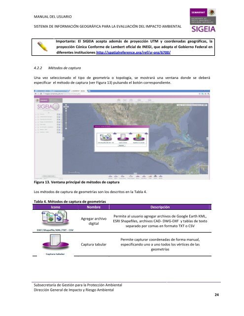
4.2.2 Métodos de captura<br />
Una vez seleccionado el tipo de geometría o topología, se mostrará una ventana donde se deberá<br />
especificar el método de captura (ver Figura 13) pulsando el botón correspondiente.<br />
Figura 13. Ventana principal de métodos de captura<br />
Los métodos de captura de geometrías son los descritos en la Tabla 4.<br />
Tabla 4. Métodos de captura de geometrías<br />
Icono Nombre Descripción<br />
Agregar archivo<br />
digital<br />
Captura tabular<br />
Subsecretaría de Gestión para la Protección Ambiental<br />
Dirección General de Impacto y Riesgo Ambiental<br />
Permite al usuario agregar archivos de Google Earth KML,<br />
ESRI Shapefiles, archivos CAD- DWG-DXF y tablas de texto<br />
separado por comas en formato TXT o CSV<br />
Permite capturar coordenadas de forma manual,<br />
especificando uno a uno todos los vértices de las<br />
geometrías<br />
24