MANUAL DEL USUARIO SISTEMA DE INFORMACIÓN ... - Semarnat
MANUAL DEL USUARIO SISTEMA DE INFORMACIÓN ... - Semarnat
MANUAL DEL USUARIO SISTEMA DE INFORMACIÓN ... - Semarnat

You also want an ePaper? Increase the reach of your titles
YUMPU automatically turns print PDFs into web optimized ePapers that Google loves.
<strong>MANUAL</strong> <strong><strong>DE</strong>L</strong> <strong>USUARIO</strong><br />
<strong>SISTEMA</strong> <strong>DE</strong> <strong>INFORMACIÓN</strong> GEOGRÁFICA PARA LA EVALUACIÓN <strong><strong>DE</strong>L</strong> IMPACTO AMBIENTAL<br />
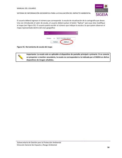
El usuario deberá ingresar el número que corresponda la escala de visualización de la cartografía que desea.<br />
Una vez introducido el valor de escala, el usuario deberá pulsar el botón “Aplicar” para que ésta modifique<br />
al mapa (ver Figura 55). El usuario podrá escribir el número que indique la escala a la que quiere observar el<br />
mapa representado dentro del visor geográfico<br />
Figura 55. Herramienta de escala del mapa<br />
Importante: La escala solo es aplicable al dispositivo de pantalla principal o primario. Si se conecta<br />
un proyector o monitor secundario, la escala no corresponderá a la indicada por el SIGEIA en dichos<br />
dispositivos de imagen añadidos.<br />
Subsecretaría de Gestión para la Protección Ambiental<br />
Dirección General de Impacto y Riesgo Ambiental<br />
50