
You also want an ePaper? Increase the reach of your titles
YUMPU automatically turns print PDFs into web optimized ePapers that Google loves.
<strong>Santa</strong> <strong>Rosa</strong><br />
National Park<br />
<strong>Santa</strong> <strong>Rosa</strong> has the most important<br />
protected Tropical Dry Forest in Central<br />
America, which includes a great variety of<br />
forest species as well as fauna. There are<br />
also 115 mammal species identified here.<br />
The diversity of insects is enormous. With<br />
butterflies alone, there are more than<br />
10000 species found in the park. The<br />
magpie jay is the most predominant bird<br />
found in the park. Among reptiles, the<br />
most common are the Olive Ridley sea<br />
turtle and the rattlesnake.<br />
Main Attractions<br />
1. <strong>Santa</strong> <strong>Rosa</strong> Area<br />
a) The tanquetas:<br />
Vehicles used during the 1955 battle.<br />
b) Tierras Emergidas Lookout:<br />
From here you can see the hills of the<br />
<strong>Santa</strong> Elena Peninsula.<br />
c) The Naked Indian Nature Trail (Sendero<br />
Natural Indio Desnudo):<br />
Here you can witness the tropical dry<br />
forest recovery process.<br />
d) Monument: This is a monument to the<br />
heroes of 1856 and 1955. From here<br />
you can observe a panoramic view that<br />
extends from the coast to the Orosí,<br />
Cacao, and Rincón de la Vieja volcanoes.<br />
e) La Casona History museum: Artifacts<br />
recovered from the battle which took<br />
place on March 20, 1856. There is also<br />
an exhibition room dedicated to the<br />
Guanacaste Conservation Area.<br />
f) Los Patos Trail: In order to arrive to this<br />
trail one must take the trail that leads<br />
to the Naranjo beach, 1.2 miles (2 km)<br />
along the campgrounds. The trail itself is<br />
about a mile (1.5 km) long.<br />
g) Naranjo Valley Lookout Trail: At the end<br />
of the trail is a lookout point from where<br />
you can observe Naranjo beach, as well<br />
as Peña Bruja (a rock formation more<br />
than 80 million years old). The trail is<br />
about one mile (1.5 km) long.<br />
2. Naranjo Area<br />
Naranjo beach is located 7 miles (12 km)<br />
from the administration offices. This beach<br />
is about 4.2 miles (7 km) in length.<br />
Due to the road conditions, one can only<br />
access with double traction vehicles during<br />
the dry months and on foot only during the<br />
rainy season.<br />
a) Carbonal Trail: Its main attractions are<br />
Danta<br />
Cómo llegar / How to arrive<br />
Tomar el bus que va desde Liberia a La Cruz y Peñas Blancas<br />
y solicitar al chofer parar en la entrada del parque. Desde<br />
ese punto hasta la caseta del guarda no hay transporte por<br />
lo que la única forma de llegar es caminando una distancia<br />
de 7 Km.<br />
Take the bus that goes from Liberia to La Cruz & Peñas<br />
Blancas and ask the driver to stop at the park’s entrance.<br />
From that point to the park ranger’s hut there is no<br />
transportation. The only way to get there is walking a<br />
distance of 4.2 miles.<br />
the Tropical Dry Forest, the mangroves,<br />
marine birds, and rock formations.<br />
b) El Limbo Lagoon: Crocodiles can be seen<br />
here.<br />
c) Aceituno Trail: Beginning next to the<br />
area’s house, one can enjoy the vegetation<br />
that runs along the coastal areas.<br />
d) Peña Bruja: An imposing rock formation<br />
that faces the beach.<br />
e) Palo Seco Trail: A trail that runs through<br />
the mangroves and leads to Naranjo<br />
beach and Estero Real.<br />
f) Estero Real: A wetland that brings<br />
together important land and marine<br />
species. Camping is not allowed.<br />
g) Nancite beach: This is the most important<br />
point in the Mesoamerica Pacific for egglaying<br />
among Olive Ridley sea turtles.<br />
Because of its ecological nature, access is<br />
RESTRICTED.<br />
Transporte / Transportation<br />
Liberia-La Cruz y Peñas Blancas:<br />
Liberia. Terminal local.<br />
Salida/Departure: 6:00 am - 6:00 pm<br />
cada hora/every hour.<br />
Duración/Lenght: 40 min.<br />
Todos los días / Everyday.<br />
Playa El Hachal<br />
3. Murciélago Area<br />
To get to this area, go 30 miles (46 km) north<br />
of Liberia until you reach the Cuajiniquil<br />
intersection, then continue some 6 miles (10<br />
km) until you get to the community and from<br />
that point continue along the gravel road<br />
for about 5 miles (9 km) until you reach the<br />
administration office.<br />
Places to see in Murciélago<br />
a) La Poza del General: A spring where you<br />
can swim along the Murciélago River.<br />
b) El Nance Circle Trail: At the high point you<br />
can see the Orosí and Cacao volcanoes.<br />
c) Los Cabros Lookout: From here you have<br />
a wide view of the coast and the nearby<br />
bays.<br />
d) El Hachal, <strong>Santa</strong> Elena and Blanca beaches:<br />
Access to these beaches is by road,<br />
accessible only by double traction vehicles<br />
during the dry season, and during rainy<br />
season just by foot.<br />
4. Murciélago Islands<br />
Here you’ll find a diversity of islands and<br />
islets, beaches, open sea, rocky coasts, and<br />
about 13 miles of nesting beaches for sea<br />
turtles. There are also coral reefs, rocky coral<br />
reefs, sand pits, rocky and deep-water areas,<br />
algae beds, and strong waves. Dolphins are<br />
common and whales can be found in the<br />
area, depending on the season.<br />
This area is one of the most important in<br />
terms of marine diversity in <strong>Costa</strong> <strong>Rica</strong> and<br />
throughout the Western Pacific.<br />
Regulaciones/Regulations<br />
• En Murciélago, <strong>Santa</strong> <strong>Rosa</strong> y Naranjo<br />
existen áreas para acampar, con los<br />
servicios básicos para el visitante tales<br />
como parrillas, agua, duchas, servicio<br />
sanitario, mesas de picnic.<br />
• In Murciélago, <strong>Santa</strong> <strong>Rosa</strong> y Naranjo<br />
you will find camping areas, with basic<br />
services like grills, running water, showers,<br />
sanitation services, and picnic tables.<br />
• Durante la época lluviosa no se permite<br />
el acceso de vehículos a Playa Naranjo<br />
y Murciélago. Durante todo el año es<br />
recomendable usar sólo vehículos de<br />
doble tracción.<br />
• During the rainy season, access by vehicle<br />
to Naranjo beach and Muciélago is not<br />
allowed. During the rest of the year, 4x4<br />
vehicles are recommended.<br />
• Playa Naranjo no posee agua potable,<br />
debe llevarla con usted.<br />
• There is no potable water at Naranjo<br />
beach. You must bring your own.<br />
• No tire colillas de cigarros, ni haga<br />
fogatas.<br />
• Do not discard cigarette butts on the<br />
ground nor light campfires.<br />
• Deposite la basura en su lugar.<br />
• Put trash in its appropriate place.<br />
• Camine únicamente por los senderos<br />
indicados.<br />
• Walk along designated trails only.<br />
Nancite - Naranjo<br />
• Lleve agua, linterna si camina de<br />
noche y zapatos de campo.<br />
• Bring water and a flashlight if you are<br />
walking at night and hiking boots.<br />
• No se permite el ingreso de mascotas<br />
• Pets not allowed.<br />
• Se prohíbe la extracción de animales o<br />
plantas.<br />
• Removal of plants or animals from the<br />
ground is prohibited.<br />
• La pesca no es permitida en todas las<br />
áreas protegidas.<br />
• Fishing is not allowed in any protected<br />
area.<br />
• El oleaje en Naranjo es fuerte y existen<br />
corrientes peligrosas.<br />
• Waves at Naranjo are strong and there<br />
are dangerous currents.<br />
• La velocidad máxima es de 40km/h<br />
• Maximum speed is 25 mph (40 kph).<br />
• Para visitar playa Nancite se requiere<br />
de un permiso especial otorgado por<br />
el Programa de Ecoturismo, en el área<br />
administrativa del Sector <strong>Santa</strong> <strong>Rosa</strong>.<br />
• In order to access Nancite beach, a<br />
special permit from the Ecotourism<br />
Program is required, which can be<br />
obtained at the administration office<br />
in <strong>Santa</strong> <strong>Rosa</strong>.<br />
• Llevar carbón o gas para cocinar en las áreas para<br />
acampar, ya que no se permite el uso de leña.<br />
• Bring coal or gas to cook in the camping areas,<br />
firewood is not allowed.<br />
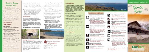
Parque Nacional / National Park<br />
<strong>Santa</strong><br />
<strong>Rosa</strong>
Parque Nacional<br />
<strong>Santa</strong> <strong>Rosa</strong><br />
<strong>Santa</strong> <strong>Rosa</strong> conserva la más importante<br />
muestra de bosque seco protegido de<br />
Centroamérica, el cual incluye gran<br />
variedad de especies forestales así<br />
como de fauna. Aquí se encuentran 115<br />
especies identificadas de mamíferos.<br />
La diversidad de insectos es enorme, sólo<br />
en mariposas, en el parque se encuentran<br />
más de 10.000 especies. Entre las aves<br />
predomina la urraca. Los reptiles más<br />
representativos son la tortuga lora y la<br />
serpiente cascabel.<br />
Principales Atractivos<br />
1. Sector <strong>Santa</strong> <strong>Rosa</strong><br />
Casona <strong>Santa</strong> <strong>Rosa</strong><br />
a) Las Tanquetas: Vehículos utilizados en<br />
la guerra de 1955.<br />
b) Mirador de Tierras Emergidas: Se<br />
observa los cerros de la Península de<br />
<strong>Santa</strong> Elena.<br />
c) Sendero Natural Indio Desnudo: Se<br />
puede observar los procesos de<br />
recuperación del bosque seco.<br />
d))Monumento: El monumento a los<br />
héroes de 1856 y 1955. Desde aquí se<br />
puede observar una vista panorámica<br />
que comprende desde la costa hasta los<br />
volcanes Orosí, Cacao y Rincón de la Vieja.<br />
e) Museo Histórico La Casona: Rescata los<br />
hechos sucedidos en la batalla del 20<br />
de marzo de 1856. Existe además, una<br />
sala de exhibiciones dedicada al Área de<br />
Conservación Guanacaste.<br />
f) Sendero Los Patos: Para llegar a este<br />
sendero se debe tomar el camino hacia<br />
playa Naranjo siguiendo 2 km del área<br />
de acampar. El sendero cuenta con una<br />
extensión de 1.5 km de distancia.<br />
g) Sendero Mirador Valle Naranjo: Al final<br />
del sendero hay un mirador en donde se<br />
puede observar playa Naranjo, así como<br />
Peña Bruja (formación rocosa de más de<br />
80 millones de años). Tiene una extensión<br />
de 1.5 km.<br />
2. Sector Naranjo<br />
A 12 km de la administración se encuentra<br />
Playa Naranjo, con 7 km de largo.<br />
Por las características del camino solo se<br />
puede ingresar con vehículo doble tracción<br />
en época de verano. Durante la estación<br />
lluviosa el acceso es solamente caminando.<br />
Peña Bruja<br />
Playa Nancite<br />
a) Sendero Carbonal: Sus principales<br />
atractivos son el bosque seco, el manglar,<br />
las aves marinas y las formaciones rocosas<br />
que se observan.<br />
b) Laguna El Limbo: Es un lugar donde<br />
pueden observarse cocodrilos.<br />
c) Sendero Aceituno: Inicia junto a la casa del<br />
sector. Se puede apreciar la vegetación de<br />
las zonas costeras.<br />
d) Peña Bruja: Es una estructura rocosa que se<br />
levanta imponente frente a esta playa.<br />
e) Sendero Palo Seco: Es un sendero entre<br />
el manglar que conecta los caminos que<br />
conducen a Playa Naranjo y Estero Real.<br />
f) Estero Real: Es un humedal donde<br />
convergen especies terrestres y marinas de<br />
gran importancia. NO se permite acampar.<br />
g) Playa Nancite: La Playa más importante<br />
del Pacífico Mesoamericano para el desove<br />
de la tortuga lora. Por sus características<br />
ecológicas su acceso es RESTRINGIDO.<br />
3. Sector Murciélago<br />
Para llegar a este sector, hay que seguir 46<br />
km al norte de la ciudad de Liberia, hasta<br />
llegar a la intersección de Cuajiniquil,<br />
luego continúa 10 km hasta llegar a<br />
dicha comunidad y desde este punto<br />
debe continuarse por carretera lastreada<br />
después de un recorrido de 9 km hasta la<br />
administración del sector.<br />
Sitios para visitar en Murciélago<br />
a) La Poza del General: Es un lugar donde<br />
se puede bañar, la poza la forma el río<br />
Murciélago.<br />
b) Sendero Circular El Nance: Llegando a<br />
un punto alto se observa las formaciones<br />
volcánicas del Orosí y Cacao.<br />
c) Mirador Los Cabros: Desde aquí se tiene un<br />
amplio panorama de la costa y las bahías<br />
cercanas.<br />
d) Playas El Hachal, <strong>Santa</strong> Elena y Blanca: Se<br />
puede llegar a estas playas por un camino<br />
accesible para vehículos de doble tracción<br />
durante la época seca y a pie en la lluviosa.<br />
4.Islas Murciélago<br />
Contiene diversas islas e islotes, playas, mar<br />
abierto, costas rocosas, y unos 20 km de<br />
playas de anidación de tortugas marinas.<br />
Incluye hábitat de arrecifes de coral, arrecifes<br />
rocosos, fondos de arena, campos de roca<br />
y de aguas profundas, camas de algas y<br />
corrientes de surgencia. Los delfines son<br />
comunes y las ballenas se encuentran en la<br />
zona, según la época del año.<br />
Este sitio uno de los más importantes en<br />
diversidad marina para <strong>Costa</strong> <strong>Rica</strong> y todo el<br />
Pacífico Oriental.<br />
To Playa<br />
Blanca<br />
To Cuajiniquil<br />
Area de Conservación Guanacaste<br />
Parque Nacional <strong>Santa</strong> <strong>Rosa</strong><br />
Sitio de patriminio Mundial - Sector <strong>Santa</strong> <strong>Rosa</strong> (11,000 ha)<br />
Puesto Murciélago<br />
Sector Murciélago<br />
(13.500)<br />
Playa Nancite<br />
Cerros <strong>Santa</strong> Elena<br />
Estación<br />
Biológico<br />
Nancite<br />
Estero<br />
Naranjo<br />
Peña Bruja<br />
Bahía Naranjo<br />
Playa<br />
Naranjo<br />
OCEANO<br />
PACIFICO<br />
Sector Marino<br />
43,000 ha<br />
Río Calera<br />
Sector <strong>Santa</strong> Elena<br />
(15.000 ha)<br />
Sector <strong>Santa</strong> <strong>Rosa</strong><br />
(11,000 ha)<br />
Road Impassible<br />
in rainy season<br />
Río Nisperal<br />
Puesto Argelia<br />
Sendero Carbonal<br />
Laguna<br />
El Limbo<br />
Cerros Carbonal<br />
O<br />
Islas Murciélago<br />
Sendero<br />
Mirador<br />
Los Patos<br />
Valle<br />
Naranjo<br />
N<br />
S<br />
Dormitorios<br />
Investigación<br />
Comedor<br />
Quebrada <strong>Costa</strong> <strong>Rica</strong><br />
Río Poza Salada<br />
E<br />
Río Cuajiniquil<br />
Casona<br />
Quebrada Guapote<br />
Hacienda Roda María<br />
Tierras Privadas<br />
Nicargua 43 Km<br />
La Cruz 24 Km<br />
Sector Pocosol<br />
(2.000 ha)<br />
Casetilla<br />
Mirador<br />
Tierras Emergidas<br />
Puesto Pocosol<br />
Carretera Interamericana<br />
Sector Horizontes<br />
(7,300 ha)<br />
Simbología<br />
Centeno<br />
Liberia<br />
35 Km<br />
Casetilla<br />
Entrance<br />
Carretera Interamericana<br />
Interamerican Highway<br />
Camino Principal<br />
Pave Road<br />
Camino Doble Tracción<br />
Dirt road (4 wheel drive only)<br />
Senderos<br />
Trails<br />
Parque<br />
Nacional<br />
<strong>Santa</strong> <strong>Rosa</strong><br />
Ríos y Quebradas<br />
Rivers and Streams<br />
Guanacaste<br />
Nicaragua<br />
<strong>Costa</strong> <strong>Rica</strong><br />
Puntarenas<br />
San José<br />
Oceáno Pacífico<br />
Sector <strong>Santa</strong> <strong>Rosa</strong><br />
Sector <strong>Santa</strong> Elena<br />
Sector Murciélago<br />
Sector Pocosol<br />
Sector Horizontes<br />
Área para Acampar<br />
Campround<br />
Mirador<br />
Scenic overlook<br />
Puesto de Guardaparques<br />
Ranger Station<br />
Casona<br />
Mar Caribe<br />
Puerto Limón<br />
Golfito<br />
Panamá<br />
Instituto <strong>Costa</strong>rricense de Turismo<br />
Departamento de Servicio<br />
al turista<br />
<strong>Costa</strong> <strong>Rica</strong>n Tourism Board<br />
Tourist Service Department<br />
Oficinas centrales/Central Offices:<br />
Tel. 2291-5764 • 2299-5800 ext. 408<br />
Fax: 2291-5720 info@visitcostarica.com<br />
www.visitecostarica.com<br />
Tel:(506)2666-5051<br />
Fax: (506)2666-5052<br />
www.acguanacaste.ac.cr<br />
ecoturismo@acguanacaste.ac.cr<br />
Horario de visita / Open hours:<br />
Todos los días / Everyday<br />
8 am - 4pm<br />
MI NAET<br />
Ministerio de Ambiente,<br />
Energía y<br />
Telecomunicaciones<br />
Parque Nacional <strong>Santa</strong> <strong>Rosa</strong>