Carte hydrogéologique de Alleur-Liège 42/1-2 - Portail ...
Carte hydrogéologique de Alleur-Liège 42/1-2 - Portail ...
Carte hydrogéologique de Alleur-Liège 42/1-2 - Portail ...

Create successful ePaper yourself
Turn your PDF publications into a flip-book with our unique Google optimized e-Paper software.
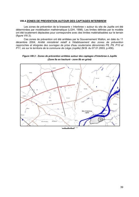
VIII.4 ZONES DE PREVENTION AUTOUR DES CAPTAGES INTERBREW<br />
Les zones <strong>de</strong> prévention <strong>de</strong> la brasserie « Interbrew » autour du site <strong>de</strong> Jupille ont été<br />
déterminées par modélisation mathématique (LGIH, 1998). Les limites définies par le modèle<br />
ont été localement déplacées pour correspondre avec <strong>de</strong>s limites matérialisables sur le terrain<br />
(figure VIII.3).<br />
Ces zones <strong>de</strong> prévention ont été arrêtées par le Gouvernement Wallon, en date du 11<br />
décembre 2004; Arrêté ministériel relatif à l'établissement <strong>de</strong>s zones <strong>de</strong> prévention<br />
rapprochée et éloignée <strong>de</strong>s ouvrages <strong>de</strong> prise d'eau souterraine dénommés P8, P9, P10 et<br />
P11, sis sur le territoire <strong>de</strong> la commune <strong>de</strong> Liège (Jupille) (M.B. du 07.01.2003, p.456).<br />
Figure VIII.3 : Zones <strong>de</strong> prévention arrêtées autour <strong>de</strong>s captages d’Interbrew à Jupille<br />
(Zone IIa en hachuré - zone IIb en grisé)<br />
39