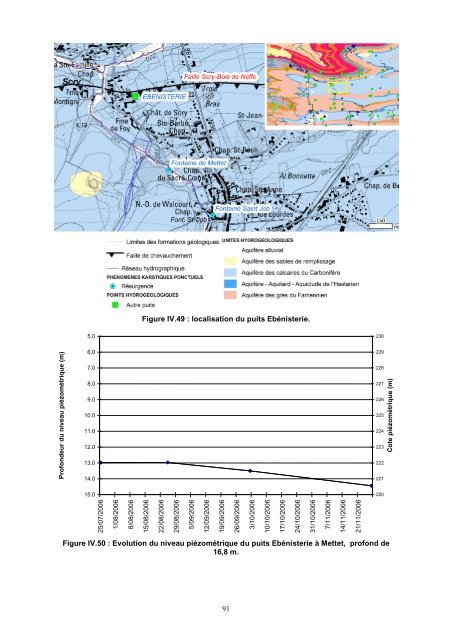
Ouvrage Localisation Z sol (m) Prof. (m) Date Mesure (m) Cote piézométrique (m) BASTIN P1 Oret 236 30 01/01/1989 4,75 231,25 BIESME CHAPELLE ST ADRIEN <strong>Biesme</strong> 222,5 30 10/05/2006 25,75 196,75 21/06/2006 25,77 196,73 ERMETON SUR BIERT GERME- 23/11/2006 21,42 203,58 Ermeton-sur-Biert 225 55 NEAU 09/05/2006 20,86 204,14 23/11/2006 2,08 247,92 GRAUX Graux 250 17 19/05/2006 1,76 248,24 17/08/2006 1,8 248,2 17/08/2006 10,82 241,68 PIEZO 3 ETUDE E-S-M Graux 252,5 40 11/10/2006 11,95 240,55 15/08/1989 9,6 242,9 PIEZO 6 ETUDE E-S-M Maison 237,5 50 10/01/1990 15,1 222,4 18/07/2005 20,31 229,69 10/01/1990 17 223 PIEZO 7 ETUDE E-S-M <strong>Mettet</strong> 248 40 17/08/2006 19,01 220,99 23/11/2006 20,5 219,5 PUITS BOCART STEPHANE Maredret 236 117 23/11/2006 57,32 178,68 19/05/2006 46,99 189,01 PUITS BODSON <strong>Mettet</strong> 235 2 01/11/1997 2 233 PUITS CERVO Oret 235 1 12/05/2006 0,87 234,13 PUITS DENIS BERNARD Ermeton-sur-Biert 222 ,5 55 09/05/2006 21,79 201,21 PUITS DENIS BERNARD Ermeton-sur-Biert 21/06/2006 21,2 201,8 PUITS DES CLOQUETTES - PP <strong>Mettet</strong> 249,3 78,39 02/08/2006 11,42 238,68 PUITS DONEUX II Oret 235 3 17/05/2006 0,71 234,29 PUITS NOTRE-DAME DE GRACE Maredret 205 60 08/10/1997 20,9 184,1 PUITS WUYARD <strong>Biesme</strong> 205 - 12/05/2006 7,9 197,1 SAUVEGARDE P2 Oret 236 25,6 01/01/1989 5 231 S.W.D.E. PR1 LEPOIVRE <strong>Biesme</strong>rée 219,69 35 25/01/1999 2,71 216,98 S.W.D.E. PR1 METTET <strong>Mettet</strong> 238,87 46 18/08/2006 9,59 230,02 17/02/2000 50,69 198,91 S.W.D.E. PR2 LEPOIVRE <strong>Biesme</strong>rée 248,65 85 22/05/2000 51,56 198,04 25/01/1999 50,55 198,1 S.W.D.E. PR2 ORET Oret 239,74 60 18/08/2006 10,48 229,73 19/07/2002 9,4 230,81 23/11/1998 8,16 222,51 S.W.D.E. PR3 LEPOIVRE <strong>Biesme</strong>rée 230,67 80 17/02/2000 28,12 202,55 22/05/2000 28,76 201,91 S.W.D.E. PR3 ORET Oret 238,<strong>53</strong> 46 18/08/2006 8,7 230,77 20/09/2002 7,09 231,44 22/05/2000 8,77 216,79 S.W.D.E. PZ1 <strong>Biesme</strong>rée <strong>Biesme</strong>rée 225,56 40 17/02/2000 7,79 217,77 25/01/1999 8,16 217,4 S.W.D.E. PZ1 ORET Oret 239,45 39 20/09/2002 7,1 232,91 18/08/2006 7,94 232,07 21/06/2006 31,63 220,26 25/01/1999 31 220,89 S.W.D.E. PZ2 <strong>Biesme</strong>rée <strong>Biesme</strong>rée 250,89 80 17/02/2000 29,67 222,22 22/05/2000 29,37 222,52 23/11/2006 32,43 219,46 S.W.D.E. PZ2 ORET Oret 2<strong>53</strong>,15 55 22/10/2003 19,32 234,63 23/11/2006 9,62 227,34 S.W.D.E. PZ3 <strong>Biesme</strong>rée <strong>Biesme</strong>rée 236,55 50 17/02/2000 3,64 233,32 25/01/1999 3,73 233,23 S.W.D.E. PZ3 METTET <strong>Mettet</strong> 255 59 20/09/2002 8,86 247,44 18/08/2006 21,82 234,48 Tableau IV.4 : Mesures piézométriques ponctuelles pour les puits implantés dans les calcaires du Carbonifère. Six puits implantés dans les calcaires du Carbonifère ont fait l’objet d’un suivi mensuel <strong>de</strong> mai à novembre 2006. Il s'agit du puits Ebénisterie à Scry (Figure IV.49), du puits <strong>de</strong> Hardimont-S1 (Figure IV.51) à <strong>Mettet</strong>, du puits Rue Bois l'Évêque II à Corroy (Figure IV.<strong>53</strong>), <strong>de</strong>s puits SWDE PR4 Stavesoul et PZ5 Stavesoul à Stave et du puits Sandow (Figure IV.55). L’évolution <strong>de</strong> leur niveau piézométrique a été reportée sur les Figure IV.50 à Figure IV.58. 90
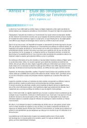
Figure IV.49 : localisation du puits Ebénisterie. 5.0 230 Profon<strong>de</strong>ur du niveau piézométrique (m) 6.0 7.0 8.0 9.0 10.0 11.0 12.0 13.0 14.0 229 228 227 226 225 224 223 222 221 15.0 25/07/2006 1/08/2006 8/08/2006 15/08/2006 22/08/2006 29/08/2006 5/09/2006 12/09/2006 19/09/2006 26/09/2006 3/10/2006 10/10/2006 17/10/2006 24/10/2006 31/10/2006 7/11/2006 14/11/2006 21/11/2006 Cote piézométrique (m) 220 Figure IV.50 : Evolution du niveau piézométrique du puits Ebénisterie à <strong>Mettet</strong>, profond <strong>de</strong> 16,8 m. 91
- Page 1 and 2:
BIESME - METTET 53/1-2 Notice expli
- Page 3 and 4:
BIESME - METTET 53/1-2 Aurélie SOR
- Page 5 and 6:
CARTE HYDROGEOLOGIQUE DE WALLONIE .
- Page 7 and 8:
IX.4. BANQUE DE DONNÉES HYDROGÉOL
- Page 9 and 10:
Les cartes hydrogéologiques de Wal
- Page 11 and 12:
II. CADRES GÉOGRAPHIQUE, GÉOMORPH
- Page 13 and 14:
Figure II.1 : Carte du réseau hydr
- Page 15 and 16:
Figure III.1 : Localisation de la c
- Page 17 and 18:
Tableau III.1 : Tableau lithostrati
- Page 19 and 20:
III.2.1.1.3 Le Dévonien III.2.1.1.
- Page 21 and 22:
le passage progressif de la Formati
- Page 23 and 24:
contiennent des bancs de calcaire g
- Page 25 and 26:
avec une lentille récifale : d’u
- Page 27 and 28:
taines poches de sable ont plusieur
- Page 29 and 30:
accourcissement général de direct
- Page 31 and 32:
IV. CADRE HYDROGÉOLOGIQUE IV.1. MA
- Page 33 and 34:
Figure IV.1 : Masses d'eau souterra
- Page 35 and 36:
Le Socle cambro-silurien affleure e
- Page 37 and 38:
Tableau IV.2 : Tableau de correspon
- Page 39 and 40:
IV.2.1.1.1 L’Aquiclude du socle c
- Page 41 and 42:
IV.2.1.1. Les nappes du Dévonien i
- Page 43 and 44: IV.2.1.2. Les nappes du Dévonien m
- Page 45 and 46: IV.2.1.2.3 L'Aquiclude du Frasnien
- Page 47 and 48: IV.2.1.3. Les nappes du Dévonien s
- Page 49 and 50: IV.2.1.3.3 L’Aquitard du Famennie
- Page 51 and 52: IV.2.1.4.2 L’Aquifère des calcai
- Page 53 and 54: IV.2.2. Le Cénozoïque Le Cénozo
- Page 55 and 56: IV.2.2.1.5 L’Aquifère des sables
- Page 57 and 58: IV.2.2.1.7 L'Aquiclude des argiles
- Page 59 and 60: de dissolution" du Condroz et de la
- Page 61 and 62: IV.3.2.1. Vallée de la Molignée L
- Page 63 and 64: Plus en aval, entre Ermeton-sur-Bie
- Page 65 and 66: IV.3.2.3. Vallée de la Biesme La B
- Page 67 and 68: IV.3.2.4. Vallée du Ruisseau de Fo
- Page 69 and 70: IV.3.2.6. Vallée du Thyria Le Thyr
- Page 71 and 72: IV.4. DESCRIPTION DE L’HYDROGÉOL
- Page 73 and 74: Hauteur d'eau (mm) 200 180 160 140
- Page 75 and 76: Figure IV.31 : localisation du puit
- Page 77 and 78: D’après les figures, le niveau p
- Page 79 and 80: sommets topographiques sont suppos
- Page 81 and 82: Quelques études ont permis une mei
- Page 83 and 84: Dans le lac de Bambois, le captage
- Page 85 and 86: Quelques mesures ponctuelles existe
- Page 87 and 88: Des données historiques existent p
- Page 89 and 90: Ouvrage Localisation Z sol (m) Prof
- Page 91 and 92: En règle générale, dans les grè
- Page 93: l’étude ESM (LGIH-ESM 894, 1989)
- Page 97 and 98: que ceux mesurés au droit du puits
- Page 99 and 100: Figure IV.55 : localisation des ouv
- Page 101 and 102: Figure IV.59 : localisation des cap
- Page 103 and 104: IV.5. COUPES GÉOLOGIQUE ET HYDROG
- Page 105 and 106: La coupe traverse, du sud vers le n
- Page 107 and 108: IV.6. CARACTÈRE LIBRE, SEMI-CAPTIF
- Page 109 and 110: Les niveaux mesurés dans les piéz
- Page 111 and 112: un continuum entre la nappe de mant
- Page 113 and 114: IV.7.1. Carrière de Gougnies Cette
- Page 115 and 116: IV.7.3. Carrière de La Marchauderi
- Page 117 and 118: IV.7.5. Les sablières de Mettet Au
- Page 119 and 120: V. CADRE HYDROCHIMIQUE Ce chapitre
- Page 121 and 122: fer et en manganèse de 2 μg/l et
- Page 123 and 124: Figure V.2 : Localisation de la Fon
- Page 125 and 126: Deux échantillons ont été préle
- Page 127 and 128: Paramètres Unités Norme Grand-Eta
- Page 129 and 130: Figure V.6 : Localisation du puits
- Page 131 and 132: Figure V.7 : Localisation de la Sou
- Page 133 and 134: Paramètres Unités Norme Source Fr
- Page 135 and 136: Figure V.10 : Localisation de la So
- Page 137 and 138: Les autres analyses indiquent une e
- Page 139 and 140: Tableau V.9 : Résultats des analys
- Page 141 and 142: Figure V.12: localisation des ouvra
- Page 143 and 144: Figure V.14 : localisation des puit
- Page 145 and 146:
V.1.8. Commentaires Les analyses ch
- Page 147 and 148:
V.2. PROBLÉMATIQUE DES NITRATES Le
- Page 149 and 150:
Suivant le réseau de surveillance
- Page 151 and 152:
V.2.2. Aquifère des calcaires du F
- Page 153 and 154:
V.2.3. Aquifère des grès du Famen
- Page 155 and 156:
Figure V.26 : Localisation du capta
- Page 157 and 158:
Figure V.28 : Localisation des ouvr
- Page 159 and 160:
Figure V.30 : Localisation de la so
- Page 161 and 162:
Figure V.32 : Localisation de la so
- Page 163 and 164:
40 35 30 25 20 15 10 5 0 sept-85 se
- Page 165 and 166:
70 Mai 2003 60 Teneur en nitrates (
- Page 167 and 168:
35 30 Teneur en nitrates (mg/l) 25
- Page 169 and 170:
V.3. QUALITÉ BACTÉRIOLOGIQUE Les
- Page 171 and 172:
Figure V.46 : Indice de qualité po
- Page 173 and 174:
Tableau V.13 : Profil des pesticide
- Page 175 and 176:
V.5. ETAT DES MASSES D'EAU Le texte
- Page 177 and 178:
Figure V.47 : Etat des masses d'eau
- Page 179 and 180:
pollutions, peuvent limiter les cap
- Page 181 and 182:
. Figure VI.2 : Volumes cumulés pr
- Page 183 and 184:
VI.1. VOLUMES PRÉLEVÉS POUR LA DI
- Page 185 and 186:
Nom de l’ouvrage Coord. Lambert x
- Page 187 and 188:
Figure VI.5 : Localisation des ouvr
- Page 189 and 190:
L’A.I.E.M. exploite trois sources
- Page 191 and 192:
La source Captage de Bonsin (Figure
- Page 193 and 194:
VI.1.8. Aquifère à niveaux aquicl
- Page 195 and 196:
L’I.N.A.S.E.P. exploite 100 000
- Page 197 and 198:
OUVRAGE Aquifère Transmissivité (
- Page 199 and 200:
Figure VII.2 : Localisation des ouv
- Page 201 and 202:
Figure VII.4 : Localisation des pi
- Page 203 and 204:
Figure VII.6 : Localisation du puit
- Page 205 and 206:
Figure VII.7 : Localisation des éc
- Page 207 and 208:
Injection Restitution Lithologie PI
- Page 209 and 210:
1. les milieux fissurés à circula
- Page 211 and 212:
500 m pour les formations aquifère
- Page 213 and 214:
VIII.2. ZONE DE PRÉVENTION AUTOUR
- Page 215 and 216:
Figure VIII.5 : Zones de préventio
- Page 217 and 218:
Figure VIII.7 : Zones de préventio
- Page 219 and 220:
Figure VIII.8 : Zone de prévention
- Page 221 and 222:
Figure VIII.9 : Zones de préventio
- Page 223 and 224:
Figure VIII.12 : Localisation des z
- Page 225 and 226:
IX. MÉTHODOLOGIE D'ÉLABORATION DE
- Page 227 and 228:
tés hydrogéologiques sont défini
- Page 229 and 230:
pompage, traçages, diagraphies, ..
- Page 231 and 232:
RODIER, J., 1996, L'analyse de l'ea
- Page 233 and 234:
XI. TABLE DES ILLUSTRATIONS Figure
- Page 235 and 236:
Figure IV.72 : Localisation de la c
- Page 237 and 238:
Figure VII.2 : Localisation des ouv
- Page 239:
XII. GLOSSAIRE DES ABRÉVIATIONS A.