Fiches nivellement - Sauveterre-de-Guyenne
Fiches nivellement - Sauveterre-de-Guyenne
Fiches nivellement - Sauveterre-de-Guyenne

Create successful ePaper yourself
Turn your PDF publications into a flip-book with our unique Google optimized e-Paper software.
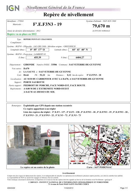
Nivellement Général <strong>de</strong> la France<br />
Repère <strong>de</strong> <strong>nivellement</strong><br />
I<strong>de</strong>ntifiant : 278941<br />
Système d'altitu<strong>de</strong> : NGF-IGN 1969<br />
Matricule : F'.E.F3N3 - 19 79,670 m<br />
Année <strong>de</strong> <strong>de</strong>rnière détermination : 2012<br />
Repère vu en place en 2012<br />
ALTITUDE NORMALE<br />
Complément :<br />
Type : REPERE PONTS ET CHAUSSEES<br />
Système : RGF93 - Ellipsoï<strong>de</strong> : IAG GRS 1980 - Méridien origine : GREENWICH<br />
Longitu<strong>de</strong> (dms) : 0° 05' 17'' O Latitu<strong>de</strong> (dms) : 44° 41' 40'' N<br />
Système : RGF93 - Projection : LAMBERT-93<br />
E (km) : 455.39 N (km) : 6404.27<br />
Département : GIRONDE Numéro INSEE : 33506 Commune : SAUVETERRE-DE-GUYENNE<br />
Voie suivie : D.670<br />
<strong>de</strong> : LA SAUVE à : SAUVETERRE-DE-GUYENNE<br />
Coté : Droit PK : 52,22 km Distance : 0,12 km du repère F'.E.F3N3 - 18<br />
Localisation : AU SUD DU CARREFOUR AVEC LA D.670, A SAUVETERRE-DE-GUYENNE<br />
Support : PORTE SAUBOTTE<br />
Partie support : PIEDROIT DU PORCHE, FACE NORD-EST, FACE ROUTE<br />
Repèrements : A 0.80 M DE L'EXTREMITE NORD-OUEST<br />
A 0.42 M AU-DESSUS DU SOL<br />
Remarques : Exploitable par GPS <strong>de</strong>puis une station excentrée<br />
Ce repère appartient à un triplet<br />
Liste <strong>de</strong>s repères du triplet : F'.E.F3 - 137 , F'.E.F3 - 138 , F'.E.F3N3 - 18 , F'.E.F3N3 - 19 , F'.E.F3N3 - 20 ,<br />
F'.E.F3N3 - 21 , F'.E.F3N3 - 22 , F'.E.N3 - 72 , F'.E.N3 - 73<br />
Le repère est au centre <strong>de</strong> la photo<br />
Carte : 1637 PODENSAC<br />
Avertissement<br />
Compte-tenu <strong>de</strong>s risques <strong>de</strong> déplacement <strong>de</strong>s repères, il est indispensable <strong>de</strong> rattacher vos opérations <strong>de</strong> <strong>nivellement</strong> à plusieurs repères proches, ceci afin <strong>de</strong> contrôler leur stabilité.<br />
La responsabilité <strong>de</strong> l'IGN ne saurait être engagée en l'absence d'un tel contrôle.<br />
Toute remarque concernant la <strong>de</strong>struction, la disparition ou le mauvais état <strong>de</strong>s repères doit être signalée au Service <strong>de</strong> la Géodésie et du Nivellement : sgn@ign.fr<br />
© 2009 IGN - INSTITUT NATIONAL DE L'INFORMATION GÉOGRAPHIQUE ET FORESTIÈRE<br />
73 Avenue <strong>de</strong> Paris 94165 SAINT-MANDE CEDEX<br />
IGN/SGN 11/02/2013 Page 1/1