Studio generale - Provincia di Viterbo
Studio generale - Provincia di Viterbo
Studio generale - Provincia di Viterbo

Create successful ePaper yourself
Turn your PDF publications into a flip-book with our unique Google optimized e-Paper software.
Lynx Natura e Ambiente s.r.l.<br />
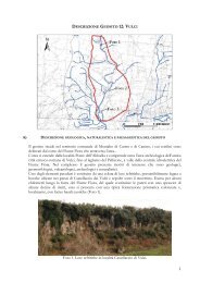
<strong>di</strong>�221�m�s.l.m.�Il�territorio�circostante�è�caratterizzato�dalla�presenza�<strong>di</strong>�forre�legate�alla�<br />
erosione� dei� tufi� del� complesso� vulcanico� Sabatino�Vicano,� nel� bacino� idrografico� del�<br />
Fiume�Treja.��<br />
�<br />
3.2. VINCOLI�NATURALISTICI�ESISTENTI�<br />
Il� pSIC/ZPS� non� è� compreso� in� Parchi� o� Riserve� Naturali� Regionali� o� Statali.� La� sua�<br />
estremità� nord�orientale� confina� con� il� territorio� del� Parco� Regionale� Suburbano� Valle�<br />
del�Treja.�<br />
�<br />
3.3. CLIMA�E�FITOCLIMA�<br />
Il� pSIC/ZPS� si� trova� secondo� Blasi� (1994)� nella� regione� fitoclimatica� xeroterica�<br />
(sottoregione�mesome<strong>di</strong>terranea)�e�presenta�un�termotipo�mesome<strong>di</strong>terraneo�me<strong>di</strong>o,�un�<br />
ombrotipo� subumido� superiore/umido� inferiore.� Le� precipitazioni� sono� abbondanti,�<br />
comprese�tra�822�e�1.110�mm,�con�apporto�estivo�tra�84�e�127�mm.�Ari<strong>di</strong>tà�estiva�poco�<br />
pronunciata.� La� temperatura� me<strong>di</strong>a� è� piuttosto� elevata,� con� freddo� poco� intenso� da�<br />
novembre�ad�aprile�e�temperatura�me<strong>di</strong>a�delle�minime�del�mese�più�freddo�da�3,4�a�4°C.��<br />
Le�con<strong>di</strong>zioni�climatiche�all’interno�della�forre�tufacee�variano�consistentemente�rispetto�<br />
al�mesoclima�<strong>generale</strong>,�in�quanto�vi�è�una�minore�insolazione�e�una�maggiore�umi<strong>di</strong>tà,�<br />
proveniente�dal�corso�d’acqua�che�vi�scorre.�<br />
Questa�maggiore�mesofilia�del�fondo�della�forra�determina�un�inversione�della�normale�<br />
seriazione�altimetrica�della�vegetazione,�con�elementi�floristici�dei�faggeti�che�occupano�<br />
le� fasce� più� basse� e� fitocenosi� <strong>di</strong>� impronta� me<strong>di</strong>terranea� nei� tratti� <strong>di</strong>� versanti� più�<br />
sommitali��(Abbate�et�al.,�1988).�<br />
Piano <strong>di</strong> Gestione pSIC/ZPS Fosso Cerreto – Parte I 13